Walk #316: Lulworth Cove to Wyke Regis
 |
 |
|
General Data
| Date Walked | 04/01/2003 |
| County | Dorset |
| Start Location | Lulworth Cove |
| End Location | Wyke Regis |
| Start time | 08.48 |
| End time | 15.22 |
| Distance | 13.7 miles |
| Description | This was a highly enjoyable walk that was in two halves; a fine and scenic cliff top walk westwards to Overcombe that was followed by a low-level walk southwards through Weymouth. |
| Pack | Today I carried my 30-litre Karrimor HotRock rucksack, which was filled with my packed lunch, waterproof leggings, water bottle and a couple of spare shirts, together with the usual assortment of odds and ends. |
| Condition | I feel absolutely fine after this walk, and have no real problems to report. Is till have the cold, but this is not as intense as it has been over the last couple of days. My ankle has been fine, as it has been over the last few days, which makes me feel as though I diagnosed the problem that I was having with it correctly. |
| Weather | Today was a lovely although cold day, with a bitter northerly wind that blew right through me when I was exposed to it. The day was mostly sunny, although some darker clouds did occasionally come over, out of one of which came a half-hour long snow flurry, my first of the winter. |
| OS map | Landranger number 194 (Dorchester & Weymouth, Cerne Abbas & Bere Regis) |
 |
 |
|
 |
 |
|
Map of the walk
Maps courtesy of Google Maps. Route for indicative purposes only, and may have been plotted after the walk. Please let me have comments on what you think of this new format. For a detailed table of timings for this walk, please see the table file.
 |
 |
|
Notes
The day started off very badly, but like most things it could have been far worse. Before we left the campsite Sam went outside to fill the water tank that resides under the seats in the rear of the van, and after about a minute I heard her tap on the window and ask me to come out. She had switched the water off as she had seen water pouring out from under the van. I went back into the van and removed the cushions from above the water tank to find the floor underneath flooded. I quickly checked the compartment beside it in which I store the computer, and this too was flooded. I moved the computer, which was fortunately raised off the floor level slightly, and set out working what had gone wrong. I soon found out that the water filer pipe, which is a corrugated plastic pipe an inch in diameter, had split halfway around, and had allowed water to leak before it reached the tank. Thanks to Sam paying attention to what was going on not too much water leaked in, and she went off to get it fixed after she dropped me off to start the walk.
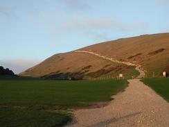
The initial part of this walk involved some fairly stiff climbs, but I managed to power my way up all of these without having to stop for rests. This shows that hopefully my body is getting more attuned to the climbs, and this bodes well for the rest of the walk along the South West Coast Path, which promises to be very hilly. By now I am feeling fitter than I have ever done before, which I suppose is to be expected after spending such a long period walking. I am quite amazed that I have managed to walk this far without any really worrying injuries; although I get little aches and pains I have yet to have anything go wrong in a major way, and hopefully this will continue to be the case for the rest of the walk.
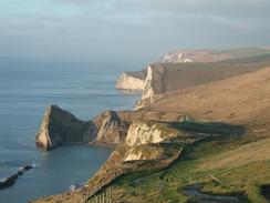
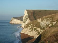
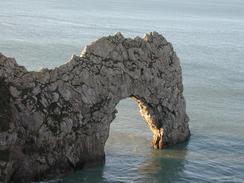
The scenery on this stretch of the walk was fantastic, particularly Durdle Door, which is a fantastic natural arch that I could not help but stand and look at for a few minutes. The sun was just rising, and I could position myself in a location where the sun was shining right through the arch, which was an amazing experience. A little further on at Scratchy Bottom (between Durdle Door and Swyre Head) I saw a tent, and as I approached I found a foreign couple in it. They were spending three days walking from Weymouth to Poole, and had spent the night in Scratchy Bottom - which must be a fantastic place to camp. They had obviously not seen the signs forbidding camping in the area, however, and I would probably not have seen them either if it meant being able to wake up in such a beautiful place.
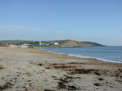
Weymouth is a very pretty little town, and I enjoyed walking through it, despite the fact that my walking boots are progressively falling apart. I met Sam in the town to have a look in the one walking shop in the town to see if they had any suitable boots. Unfortunately the Blacks store, despite having some very helpful staff, did not have any boots that met my specifications and so I will have to try to ensure that these boots hold together for longer. This could be a problem, as the soles are now getting quite thin and the grip has worn off a section of the heel. This wear is so bad that using them on slippy sections may not be wise, and I may move onto my old pair of Salamon boots for these. I am loathe to do this as these old boots are nowhere near as comfortable as my current ones, however.
We parked the van in the car park of the Ferry Bridge Inn in Wyke Regis, and we went into the inn for a pint and to ask permission to stay in the car park. This was duly and kindly granted, and the views over to the Isle of Portland have given me an idea. Tomorrow instead of walking westwards past Abbotsbury I may do a fourteen-mile circuit of the Isle. Although this was not on my original route plan I quite fancy the idea of doing this walk, a route for which is outlined in the South West Coast Path Association guidebook. Doing this has advantages and disadvantages; on one hand it increases the total mileage walked (a good thing) but on the other hand it delays me by a day. Since I am several days ahead of schedule at the current time I believe that I shall probably do the walk and delay my progress westwards by a day.
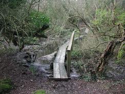
When I reached Ringstead I dropped down from the path onto the wide shingle beach and walked along this. I passed a little boathouse on the right and continued on. The beach became quite rocky as the cliffs rose up to my right, but I was busy scanning the ground for fossils and looking at the brave surfers in the water. As I passed a headland I saw that the cliffs were getting higher and the beach narrower, so I decided that it would be best to go back to the path. I walked back to the hut and took a footpath beside a stream for about twenty yards through the scrubland to the footpath. It always annoys me when I get something wrong like this, especially when it is an unforced error.
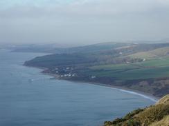
As I walked the next section to Osmington Mills it started to snow, a light, wind blown snow that was absolutely fantastic to walk through. In many places the sky was blue, and the snow really made me feel happy as I walked. There were lots of people out walking the section between Weymouth and Lulworth, and I feel as though I stopped and chatted to most of them. In particular there was one lady whom I met in Osmington Mills who has been walking the South West Coast Path in sections for a few years, and I chatted to her for five minutes about the walk. It is so nice talking to other long distance walkers, as it really makes me feel as if I am part of a crowd, part of a larger group of people with similar ideas to me.
Directions
| During this walk I followed the South West Coast Path, the route of which is detailed in the Ordnance Survey National Trail Guide 11, Exmouth to Poole (ISBN 1-854109-88-X). Unfortunately the route description is written in reverse to the direction that I am walking, but the 1:25,000 maps in the book are clear and the signs on the ground are very good. Also to be recommended is the South West Coast Path Association guidebook (ISBN 0-907055-04-4), which has less concise directions and no maps but does include accommodation details and grades each section of the walk according to difficulty. They also publish reverse directions, which are suitable for walking in the direction that I walked the route. They have a website at www.swcp.org.uk, which is well worth a visit. | 
|
| 
| |
| |
| |
Distances
| From | To | Distance (m) | Ascent (ft) | Descent (ft) |
|---|---|---|---|---|
| Lulworth Cove | Osmington Mills | 6.1 | 1719 | 1706 |
| Osmington Mills | Weymouth | 4.6 | 545 | 617 |
| Weymouth | Wyke Regis | 3.0 | 328 | 322 |
This makes a total distance of 13.7 miles, with 2592 feet of ascent and 2645 feet of descent.
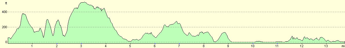
For more information on profiles, ascents and descents, see this page
Accommodation
We parked in the car park at the Ferry Bridge Inn in Wyke Regis, who allowed us to stay in their car park free of charge, which was kind of them.
Disclaimer
Please note that I take no responsibility for anything that may happen when following these directions. If you intend to follow this route, then please use the relevant maps and check the route out before you go out. As always when walking, use common sense and you should be fine.
If you find any information on any of these routes that is inaccurate, or you wish to add anything, then please email me.
All images on this site are © of the author. Any reproduction, retransmissions, or republication of all or part of any document found on this site is expressly prohibited, unless the author has explicitly granted its prior written consent to so reproduce, retransmit, or republish the material. All other rights reserved.
Although this site includes links providing convenient direct access to other Internet sites, I do not endorse, approve, certify or make warranties or representations as to the accuracy of the information on these sites.
And finally, enjoy your walking!
This walk was mentioned in the following routes:
| My walk around the coastline of Britain |
| South West Coast Path |
Nearby walks
| # | Title | Walk length (miles) |
|---|---|---|
| 315 | Worth Matravers to Lulworth Cove | 12.7 |
| 317 | A circular walk around the Isle of Portland | 13.3 |
| 318 | Wyke Regis to West Bexington | 14.3 |
|
|

|