Walk #315: Worth Matravers to Lulworth Cove
 |
 |
|
General Data
| Date Walked | 03/01/2003 |
| County | Dorset |
| Start Location | Worth Matravers |
| End Location | Lulworth Cove |
| Start time | 08.02 |
| End time | 14.04 |
| Distance | 12.7 miles |
| Description | This was a strenuous walk along high cliffs that had allowe me some absolutely superb views. |
| Pack | Today I carried my 30-litre Karrimor HotRock rucksack, which was filled with my packed lunch, waterproof leggings, water bottle and a couple of spare shirts, together with the usual assortment of odds and ends. |
| Condition | I feel better than I did after yesterday's walk, despite this one being more strenuous. I did not run out of energy, and my ankle and legs are fine. I still have a streaming cold, and this was annoying me throughout the walk. |
| Weather | The high winds of yesterday afternoon passed during the night, and left behind it mostly sunny skies with only a few clouds to hamper the views. It got progressively colder through the day, until eventually I was quite chilly. It is definitely nowhere near as mild as it was a few days ago, and the forecast is for it to get colder still. Winter is definitely upon us. |
| OS map | Landranger number 195 (Bournemouth & Purbeck, Wimborne Minster & Ringwood) and Landranger number 194 (Dorchester & Weymouth, Cerne Abbas & Bere Regis) |
 |
 |
|
 |
 |
|
Map of the walk
Maps courtesy of Google Maps. Route for indicative purposes only, and may have been plotted after the walk. Please let me have comments on what you think of this new format. For a detailed table of timings for this walk, please see the table file.
 |
 |
|
 |
 |
|
Notes
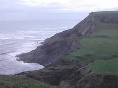
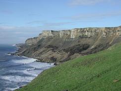
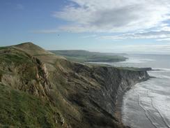
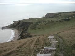
The South West Coast Path Association handbook marks the section from Kimmeridge to Lulworth as severe, and it is easy to see why. The route contains very few, if any, level sections, and it dips up and down as it heads through the army ranges. The whole of today's walk was fairly spectacular, with great view being available over the cliffs and sea when the sun was out. The initial section as far as Kimmeridge was very muddy, the ground having being chewed up by walkers' boots, but the section through the army ranges was far better as the paths are shut for such a long period.
Early on in the walk I saw a couple of deer in the Hill Bottom area. They were both quite near me when I approached, and they then ran away from me, bounding over the scrubland and grass at great speed. It is rare that I get to see deer, and when I do I cannot help but be impressed by the animals, even when they are small deer as these examples were. I took my sighting of them to be a good omen and started singing as I continued walking, to warn any other wildlife in the area of my impending arrival (or scaring them off - I am not known for my vocal talents!)
You cannot get an impression of the steepness of some of today's climbs and descents from photographs. Having got back to the campervan tonight and downloaded all the photographs off my camera, I can see that photographs of steep ascents or descents do not seem as steep as when I was actually taking the photographs. Context is probably something to do with this - with a photo you do not get such a large vision of the world, or do not know where the horizon is. So when looking at some of the ascents and descents on this page, remember that some of them are quite steep and, in some cases, very muddy. Towards the end of the day when standing on the cliffs of Bindon Hill I could see clearly back as far as St Aldhelm's Head, and just about make out the white cottages on that headland. The views really were that fantastic, and Weymouth and the Isle of Portland were also clearly visible.
I had been concerned about whether the army ranges at Lulworth were open, so I had asked Sam if she could ring them up in the morning to find out. When I finally got mobile reception near the top of Hans-tout I received a text message from her that stated that it was open until next Monday, so it was fine to walk through. This really was very handy, as I did not fancy having to make the diversion around the ranges that would have taken me nearly as far as Wareham inland! When I reached the ranges some civilian contractors were digging a trench for a cable immediately inside the security gates. Apparently walkers are ignoring the signs when the range is closed, skirting around the gates and walking through the ranges! To counter this the army are installing cameras so anybody entering the site when the range is closed to the public can be detected. I cannot imagine why anybody would want to try to walk through an army range when it is obviously closed - there are enough warning signs about in the area.
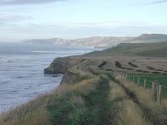
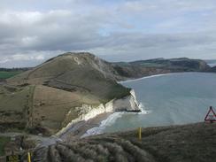
The walk through the army range was well worth the effort. The route was easy to follow a it was marked by bright yellow posts and forbidding signs warning of unexploded shells, and he views were magnificent. It was possible to make out the village of Tyneham below, complete with visitors cars in the large car park. The village was abandoned in 1943 when the army took over the surrounding land to form the ranges, and the village is open to visitors between certain times whenever the range is open. Later on to the north below Bindon Hill I could see the remains of many tanks and armoured personnel carriers lined up - whether these are targets or are being cannibalised for spares I do not know. The whole northern flank of the hill is scared by white tracks cut into the hillside, and the hillside below the footpath was littered with pieces of contorted metal, shrapnel from shells and other scrap. I certainly would not want to be on that hillside when the army are playing!
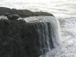
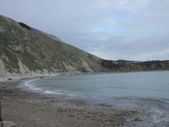
I must admit that I was disappointed by Lulworth Cove. I remembered the cove from countless geography lessons when I was a child, and had been looking forward to seeing it for myself. Unfortunately when I got there I found that you really could not get a good idea of the scale of the place. Most of the photographs I had seen of it were from the air, where the entirety of the cove could be seen, but standing on the cliffs above it or on the shingle beach below the cliffs I could not get the whole thing in view. I had probably been spoilt by all of the magnificent views that I had had all day, but the cove did not impress me as much as I had hoped. Also a disappointment was the fossilised forest, which is to the east of the cove. This is an area where the remains of some trees from the Jurassic - 135 million years ago, are to be found. I stood on top of the cliffs and could see the circular remains of some of the gymnosperms (early coniferous trees), and one longitudinal section through a trunk, but these did not seem at all impressive to me. I was tempted to go down onto the ledge where they reside for a closer look, but the last section of the walk had taken longer than I had expected and I was late to meet Sam in the car park at Lulworth Cove.
Directions
| During this walk I followed the South West Coast Path, the route of which is detailed in the Ordnance Survey National Trail Guide 11, Exmouth to Poole (ISBN 1-854109-88-X). Unfortunately the route description is written in reverse to the direction that I am walking, but the 1:25,000 maps in the book are clear and the signs on the ground are very good. Also to be recommended is the South West Coast Path Association guidebook (ISBN 0-907055-04-4), which has less concise directions and no maps but does include accommodation details and grades each section of the walk according to difficulty. They also publish reverse directions, which are suitable for walking in the direction that I walked the route. They have a website at www.swcp.org.uk, which is well worth a visit. | 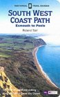
|
| 
| |
| |
| |
At the start of today I walked westwards along a muddy track from the church in Worth Matravers towards the cliff top path at West Cliff, via Weston Farm.
Distances
| From | To | Distance (m) | Ascent (ft) | Descent (ft) |
|---|---|---|---|---|
| Worth Matravers | West Cliff | 1.1 | 75 | 108 |
| West Cliff | Gaulter Gap, Kimmeridge | 4.7 | 1079 | 1411 |
| Gaulter Gap, Kimmeridge | Lulworth Cove | 6.9 | 2123 | 2126 |
This makes a total distance of 12.7 miles, with 3277 feet of ascent and 3645 feet of descent.
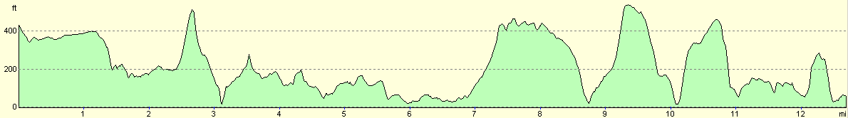
For more information on profiles, ascents and descents, see this page
Accommodation
We stayed at the Warmwell Country Touring Park, Mundays Caravan Park Limited, Warmwell, Dorchester, Dorset, DT2 8JD. They can be contacted via email at warmwell@btopenworld.com. This site was quite a distance away from where we finished the walk, but it was the only one in the area that could take us in over the New Year. We wanted a site as we had visitors staying, so staying at the side of a road was not really applicable. The site cost us eleven pounds for the night, and was reasonably well appointed with a nice bar. The showers were not particularly hot, which annoyed me slightly as my aching muscles were severly in need of a relaxing, warm shower.
Disclaimer
Please note that I take no responsibility for anything that may happen when following these directions. If you intend to follow this route, then please use the relevant maps and check the route out before you go out. As always when walking, use common sense and you should be fine.
If you find any information on any of these routes that is inaccurate, or you wish to add anything, then please email me.
All images on this site are © of the author. Any reproduction, retransmissions, or republication of all or part of any document found on this site is expressly prohibited, unless the author has explicitly granted its prior written consent to so reproduce, retransmit, or republish the material. All other rights reserved.
Although this site includes links providing convenient direct access to other Internet sites, I do not endorse, approve, certify or make warranties or representations as to the accuracy of the information on these sites.
And finally, enjoy your walking!
This walk was mentioned in the following routes:
| My walk around the coastline of Britain |
| South West Coast Path |
Nearby walks
| # | Title | Walk length (miles) |
|---|---|---|
| 313 | Hamworthy Station to South Haven Point | 18.0 |
| 314 | South Haven Point to Worth Matravers | 16.7 |
| 316 | Lulworth Cove to Wyke Regis | 13.7 |
|
|

|