Walk #744: Glyndwr's Way: Llangadfan to Dolanog
 |
 |
|
General Data
| Date Walked | 27/09/2006 |
| County | Powys |
| Start Location | Llangadfan |
| End Location | Dolanog |
| Start time | 08.45 |
| End time | 15.41 |
| Distance | 15.8 miles |
| Description | This was a pleasant walk, although there were not particularly any spectacular views to be had, mainly due to the large patches of coniferous plantations that it passes through. There is a significant amount of ascent and descent during the day, and there are some good views from some of these. |
| Pack | Today I carried my 30-litre Karrimor rucksack filled with my waterproofs, three litres of water, and various other odds and ends. |
| Condition | The biggest problem I have had today is with the area between my toes on my right foot, which started hurting yesterday. I put a Compeed on this overnight, but it was aching significantly at times during todays walk. Aside from this I had no problems - I had put a patch of Moleskin on the chaffing on my back, and this caused me no problems during the day. |
| Weather | The day was dark and overcast for all of the day, with the clouds being swept along by an increasing wind as the day went on. There was no sunshine all day but it was still a warm day for the time of year. There were a few spits and spots of rain throughout the day, but this did not become heavy until after I had finished the walk. |
| OS map | Landranger number 125 (Bala & Lake Vyrnwy, Berwyn) |
 |
 |
|
 |
 |
|
Map of the walk
Maps courtesy of Google Maps. Route for indicative purposes only, and may have been plotted after the walk. Please let me have comments on what you think of this new format. For a detailed table of timings for this walk, please see the table file.
 |
 |
|
 |
 |
|
Notes
I awoke this morning and had a shower first thing; normally I would only have one in the evening when walking, but I wondered if having another one would help prevent the chaffing that I had been suffering from (although it was not too bad today). Breakfast was schedules for 07.30, so fairly soon after the shower I was heading down for what turned out to be a wonderfully large breakfast, and I found myself wondering if I would be able to finish it all. I was in an indecisive mood, and as the weather was going to be wetter further west I was tempted to walk the stretch from Dolanog to Welshpool, where the chances are it would be drier for longer into the afternoon. The landlady got me the phone number for a taxi firm in Welshpool, and I phoned them up to find out that a taxi would cost fourteen pounds, not too much.
After another discussion with the landlady she offered to pick me up from Dolanog this afternoon. This would have the effect of reducing today's walk by four miles, and meant that I should be able to finish it before the rain starts too heavily. This would also have the advantage of meaning that I will be able to finish Glyndwr's Way tomorrow at the official end in Welshpool, rather than doing the days out of sequence. Therefore I accepted the offer, got ready, and with a rather full stomach headed off down the road.
As I had been having trouble with my feet over the last couple of days due to my leaking boots, I decided to try wearing my new pair of Meindl boots today. The last six pairs of boots that I have worn have been Scarpa Trek 2's, but as they are no longer made I have had to choose another pair. This is difficult for me as I have metal in my left ankle, and some boots nearly cripple me. The Scarpa boots had worked very well, and although I bought the Meindl's two months ago I have yet to wear them on a 'proper' walk, as the leather presses against some of the metal. The most I had managed was a seven mile walk around Castleton with Sencan, and at the end of that walk my ankle was hurting. The last four mile walk that I had done in them had been fine, however, so I decided to try them out again today.
It took me a couple of minutes to walk from the hotel (which was apparently built in 1310) to Glyndwr's Way, and with a full stomach I joined the road that headed away from Llangadfan. After a few hundred metres I was expecting the Wya to head off down the driveway leading towards Blowty, but an official-looking sign on the gate stated that the path was temporarily closed, and I had to follow the road instead. This was a little longer than the official route, and there were not particularly any good views to be had over the high hedges. The road rose and fell, but before long I reached the end of the diversion and rejoined Glyndwr's Way at a road junction.
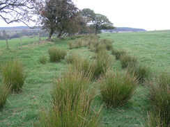
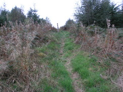
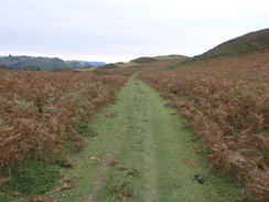
This headed northwards down a sunken green lane, which according to the guide book is probably an old Drover's Road. It descended to a stream, where the ground was boggy, and then climbed up to meet a road. As I tried to cross the boggy area I was quite glad that I was wearing my new boots, as no moisture got in, as would have been inevitable in my old pair. After the road the path entered some woodland, initially following a path that rose through the trees, before joining a track. There were some decent views to the southwest, although the clouds overhead meant that they were not as good as they could have been.
What followed was a long walk through the forest on a good track, heading rouhgly northwards through the forest. Views were minimal, but for most of the way the going was good. A minor track followed, and then a path as the Way left the woods and descended towards a stream. The area around this was dark and surrounded by trees, and the wood of the footbridge that crossed the stream had a green patina. On the other side the way joined a track that rose and fell as it skirted the edge of some woodland, eventually becoming surfaced as it passed a farm. The tarmac enabled me to keep up a good pace even as the road climbed and fell, and as the views were limited to occasional glimpses by the hedge to my right I kept my head down, and before I knew it I was passing a caravan park and crossing the bridge over the Afin Cownwy to reach Ddol Cownwy.
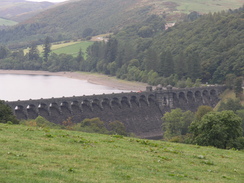
A road led up for a sort distance, before a very steep track led uphill. I ignored a couple of benches situated at the bottom and near the top of the path and instead struggled up, hating the steepness of the climb. It seemed to take me forever to reach the top, and when I did I walked along the shallower gradient with some joy as I used the break to get my breath back. A descent followed, and when the Way left the woodland I got my first glimpse of Lake Vyrnwy and its dam. This was made of stone and had an elegant string of overflow arches along the top, and was of a very different design to the mass concrete dam of Clywedog Dam that I had passed on Saturday. I normally prefer stone to concrete, but for some reason I seemed to prefer Clywedog - perhaps it was the dreary skies overhead, or the fact that I was only getting glimpses of the stonework, but the Clywedog dam seemed to have more character.
A path fell steeply down a field, and I was discovering that the soles on my new boots were far grippier than my old pair had been, which I was thankful for on the descent along wet grass. There were only occasional glimpses of the dam to be seen, and eventually it disappeared totally from sight as the Way joined a road in Llanwddyn by a phone box. There is a visitor's centre just up the road and I was tempted to go and visit it, but I wanted to move on, especially as I was disappointed by the dam itself (I shall have to come back in sunny weather to get a better view of it to see if I am doing it justice).
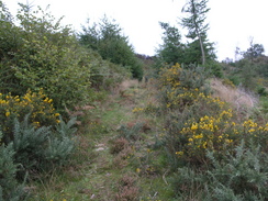
The Way followed a road for a short distance, before skirting trees towards Gwrn-oer. Here the Way seemed to enter a gate into someone's back garden before joining a green lane that headed eastwards, descending slowly towards Abertridwr. This was a fairly intersting walk, at least when compared to the next stretch, which followed the B4393 road as it headed uphill. Although the road was quiet and the views were reasonable, I did not really enjoy the long uphill slog, and I was glad when a hairpin was reached and the Way headed off down another road. This led to a forest track that climbed uphill; at the top there was a lone Forestry Commission van, with a man reading a book sitting inside. The track then descended through the trees before ending at a road.
A short distance further on a footpath headed off uphill through a recently replanted area of woodland. The path was very steep and slightly overgrown, but as the trees were not mature there were some reasonable views. It was a hard climb, but by now my legs were warmed up and I soon reached a track at the top. There then followed a long descent down to Pont Llongel, the church in the village being visible for a long time before I reached it along paths that headed through recently replanted woodland and fields. I found myself wishing that I was at the church, but the wishes did not bring it any nearer.
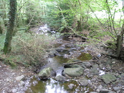
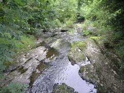
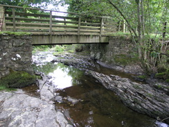
Eventually I passed it and, ignoring the Post Office a few yards away along the road, descended the short distance to the bridge over the Afon Vrynwy. Here there was a car park and some picnic tables, but instead of having a rest here I walked on along the path that runs beside the river. This was a very pleasant walk, but views of the river below were sparse due to the trees that lined the bank - there were not many places where I could get a good photograph. At the end of the path there was a footbridge, and down to the left there were some rocks sloping down to a stream, and I decided to stop for a rest, sitting down on the slippery rocks and watching the waters flow under the bridge to me left.
I took my right boot off as the injury above my toes that I had put a Compeed on was hurting. I was pleased that these new boots appeared to be causing me no discomfort, but when I took my sock down the wound between my toes was weeping and full of puss. It was not very pleasant and sore to the touch, but I decided not to out a plaster on top of the Compeed and to leave that for the morning, when I can do a better job of it. I then ignored my foot and stared at the water, the sound and sight lulling me, and before I knew it fifteen minutes had passed.
Eventually I pulled my boot back on and headed off along the path, which left the river and followed a hedge up hil. At the top if bruised the base of my right hand trying to open a gate, and I flexed my hand repeatedly to try and ease the discomfort as I walked along the path, which led to a road.On the other side the Way passed a farm that had a lovely barn - stone up to first floor level, and above a wooden frame infilled with brick. A green lane led on eastwards, eventually descending to Pentre Farm. As I entered the farmyard I was greeted by a Collie dog and five young puppies, yapping around my heels as I went through the yard The farmer greeted me, and we chatted for a few minutes about farming and the Way - apparently the puppies are only five or six months old, and will bark at anything.
The Way descended along a road to cross a stream before climbing along a green lane, an enjoyable stroll once the gradient had slackened. After about a mile it left the lane and headed southwards, crossing fields before dropping down towards a road. Here I got slightly confused - the Way dropped down to a surfaced track leading to a farm, and I headed the wrong way for a short distance before realising my mistake and climbing back up and following the track to the road.
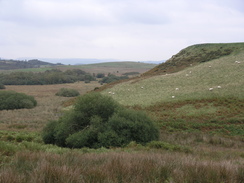
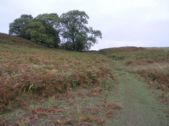
The next stretch of path headed across moorland to the east of the summit of Allt Dolanog, and was by far the bets stretch of the day's walk as it headed across some beautiful moorland, the craggy summit exposing rocks amongst the browning autumnul heather. I was in seventh heaven, and I could have walked through the terrain forever. Unfortunately this was not to be, and the Way descended, joining a green lane that ended by a chapel in Dolanog.
I passed a free car park and descended to another church by the river bridge. Here I phoned up the landlady, and she told me that her husband would be here to pick me up in twenty minutes. I went back up to the car park, where there was a lovely marker for the start of the Ann Griffiths Way, a seven mile trail following the river. The marker was in the form of a metal book, with leaves and other items protruding from the surface. Beside the marker was a wooden bench with a back made of two leaping salmon, and I sat down on this whilst I waited. It started to spit with rain whilst I waited and I out my coat on, but it did not last long and the lift soon arrived. On the way back I discovered that the driver had lived for several years in Derby and we chatted about the differences between the Welsh and Derbyshire landscapes.
This evening I went down to the bar at about six thirty and ordered a delicious Lasagne and a few pints over a couple of hours, whilst I read and chatted to some of the other guests. There are three BT engineers from Newcastle currently staying over, finding faults in the lines. Apparently they are more used to working in the city where the lines are buried and not overhead, and one said that he had to remember how to tie up the ladders that are stored on the top of his van, it is so long since he last used them.
Tomorrow I should have and eighteen or nineteen mile walk to reach the end of the Way in Welshpool, where I will have to get a taxi back to my car. I have little doubt that I will complete it, and it feels good that I will finally have completed the trail after my aborted attempt last year.
Directions
|
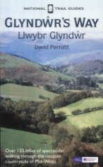
The walk is also covered in detail in the Glyndwr's Way National Trail Guide, by David Perrott, ISBN 1 85410 968 5, published by Aurum Press Ltd. Please click on the link to the right to access the Amazon page for the guidebok. |
|
Distances
| From | To | Distance (m) | Ascent (ft) | Descent (ft) |
|---|---|---|---|---|
| Llangadfan | Llanwddyn | 7.1 | 1486 | 1237 |
| Llanwddyn | Pont Llogel | 4.1 | 692 | 919 |
| Pont Llogel | Dolanog | 4.6 | 807 | 892 |
This makes a total distance of 15.8 miles, with 2985 feet of ascent and 3048 feet of descent.
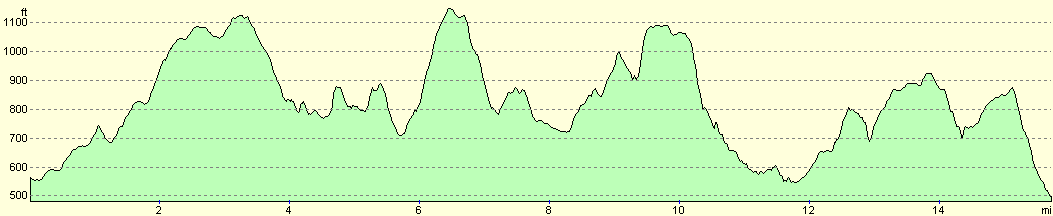
For more information on profiles, ascents and descents, see this page
Accommodation
I spent the night at the Cann Office Hotel, which cost me thirty pounds for the night in a double en-suite room. This was a pleasant place to stay, with several small bars and good food available at the bar in the evening, and a massive breakfast in the mornings. They can be contacted at the Cann Office Hotel, Llangadfan, Welshpool, Powys, SY21 0PL, telephone (01938) 820202, or email cannoffice@tiscali.co.uk.
Transport
The hotel that I am staying in kindly gave me a lift back to the start of the walk, and I do not think that there are any public transport services in that direction (you would have to change in Welshpool using the infrequent bus services). If you wish to walk instead, the start is four miles to the west, and there is what appears to be a good footpath heading in that direction on the map.
Disclaimer
Please note that I take no responsibility for anything that may happen when following these directions. If you intend to follow this route, then please use the relevant maps and check the route out before you go out. As always when walking, use common sense and you should be fine.
If you find any information on any of these routes that is inaccurate, or you wish to add anything, then please email me.
All images on this site are © of the author. Any reproduction, retransmissions, or republication of all or part of any document found on this site is expressly prohibited, unless the author has explicitly granted its prior written consent to so reproduce, retransmit, or republish the material. All other rights reserved.
Although this site includes links providing convenient direct access to other Internet sites, I do not endorse, approve, certify or make warranties or representations as to the accuracy of the information on these sites.
And finally, enjoy your walking!
This walk was mentioned in the following routes:
| Glyndwr's Way |
Nearby walks
| # | Title | Walk length (miles) |
|---|---|---|
| 743 | Glyndwr's Way: A circular walk from Llanbrynmair to Llangadfan | 23.8 |
|
|

|