Walk #743: Glyndwr's Way: A circular walk from Llanbrynmair to Llangadfan
 |
 |
|
General Data
| Date Walked | 26/09/2006 |
| County | Powys |
| Start Location | Llanbrynmair |
| End Location | Llanbrynmair |
| Start time | 07.39 |
| End time | 17.22 |
| Distance | 23.8 miles |
| Description | This walk took me northeastwards along Glyndwr's Way, before returning partially along the same route. It comprised a mixture of hill and road walking, and at times there was some enjoyable moorland walking. |
| Pack | Today I carried my 30-litre Karrimor rucksack filled with my waterproofs, three litres of water, and various other odds and ends. |
| Condition | I have no major problems after this walk, but I do have a number of minor niggles. I have a raw area above the toes on my right foot where the boot has been rubbing,and the chaffing and heat rash around my ankles is also uncomfortable. The worst thing is heat rash at the base of my back where the hip belt goes, which is very uncomfortable. |
| Weather | The day started off cloudy with patchy fog lying in the valleys. The cloud layer was below the tops of the hills, but as the morning went on it slowly lifted to revel a day of a mixture of sunshine and cloud. It was quite a warm day for the time of year, and there was not particularly much wind to chill me. |
| OS map | Landranger number 136 (Newtown, Llanidloes & surrounding area) and Landranger number 125 (Bala & Lake Vyrnwy, Berwyn) |
 |
 |
|
 |
 |
|
Map of the walk
Maps courtesy of Google Maps. Route for indicative purposes only, and may have been plotted after the walk. Please let me have comments on what you think of this new format. For a detailed table of timings for this walk, please see the table file.
 |
 |
|
 |
 |
|
Notes
I had a rather unsettled night, and I awoke at about six raring to go. I had done most of my packing last night, and so it was just a case of preparing my body (mainly a couple of compeeds on sore spots on my feet), before getting dressed and taking my bags out to the car. As the other guests were still asleep I tried not to make any noise, so it took me longer than expected to pack the car up. After the trouble I had starting it last night I put my keys in the ignition and turned them with trepidation, and I was relieved when it started first time. It was just starting to get light, and so I set off quietly and headed down the road to Llanbrynmair and the start of the walk.
I pulled my car up in the car park at about seven fifteen, and ate a pack of small Eccles cakes whilst I slowly arranged my kit. The post office a few yards away from the car park did not open until seven thirty, and so I waited around for it to open, eventually buying a bottle of Ribena to drink on the trip. Eventually I locked my car up and set off, crossing the main road and heading under a railway bridge as I walked down a quiet lane, a trip that I had made in reverse at the end of yesterday's walk. This was soon left behind and a track took me onwards, and I suddenly found myself feeling very tired and sleepy, indeed, I felt absolutely shattered.
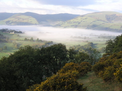
As I walked along the good, even surface of the track I closed my eyes for periods, and this meant that I was not paying attention to the route, and after a few minutes it was obvious that I had walked too far. Turning back, I found the stile beside the track and start heading along a path across fields, the dew-wet grass soon getting my boots wet. The path crossed a footbridge before climbing steeply for a period to join a track that was initially distinct before becoming indistinct as it turned sharply twice to zigzag up the hill. As it rose I got some good views towards the village across the fog-filled valley, with the last vestiges of a red sky hanging overhead.
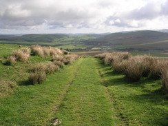
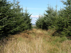
After the top of the hill was reached the path remained more or less level as it headed northwards, dropping slightly to Bwlch Gwyn before continuing on. It was a good walk, although by this time I was in the cloud layer and the views were virtually non-existent, and I found myself wishing that the sun was shining. At times the Way followed a track, and the relative levelness of the walk made it all the more enjoyable, and not in the least strenuous. Eventually the track ended and the Way followed a fence across a field to the start of another track, which headed down towards an area of coniferous woodland. I could not see the trees until virtually the moment that I came across them, the cloud still hanging thickly around me.
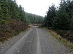
The track through the forest was initially nice and wide, and as it joined another track after a mile there started to be glimpses of the sun overhead. It continued along this track uphill for a while, before turning right down a muddy track that looked like it was being renovated, descending steeply before levelling out. Whereas the main track had been wide and airy, this track was much more enclosed by the trees and gloomy. In parts the track was reasonably rough, and it was with slight relief that it ended and a path emerged out of the trees into an area of rough ground. The path headed straight on, climbing slightly uphill to the southeast to reach the side of a fence. It follows this as it slowly heads downhill, swapping over to the other side of he fence as it heads towards a little hillock. It skirts around the far side of this, to join a track that headed eastwards downhill, initially steeply but the gradient slowly declining until it ends at a T-junction with a road.
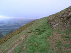
Glyndwr's Way then followed this road northwards for a little over a mile, passing a farm at Neinthirion on what was a pleasant, good stroll as the road gently rose and fell. I put my mind in neutral and walked along, being passed by only one car before the route eventually turned off and headed down towards the farm at Dolwen. In the yard a cow was being introduced to a bull that was caged up, and I had to squeeze past before joining a track that headed uphill, gently at first but fairly soon started to climb more steeply, and the views behind me started to unfold spectacularly. Once the track petered out a path led on, zig zagging up the hillside before entering an area of rough ground, and with joy I followed the frequent waymarkers across the ground, enjoying the views and the wild scenery all around me. Just before the path started going downhill near a rocky outcrop I went slightly wrong, following the incorrect path downhill.
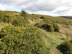
I soon realised that I was heading in the wrong direction, and I decided to stop for a brief rest. Carefully I sat down after finding a patch without sheep droppings, and as I looked at the views and listened to the radio I munched a few chocolate digestives, washed down with the Ribena that I had bought earlier. It was a magnificent place for a stop, and I took my boots off to let them cool down as I got lost in speeches being broadcast from the Labour party conference. Eventually I had to go, and instead of heading back up the short distance to the proper path I decided to head across the trackless moorland, weaving joyfully around clumps of gorse before rejoining the Way as it headed down towards a footbridge over a stream.
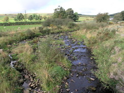
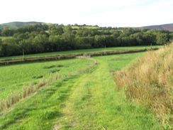
The next stretch to Llangadfan was not very enjoyable, as the path headed across a series of small fields, rising and falling before eventually passing the farm at Bryncyrch and joining a road. The only good point of this stretch was the entrance to the village itself, where the Way left the road and crossed a small footbridge over the Afon Banwy to reach the A458(T). Here I had a choice to make; I could either head back the same way, or find a different route. As I did not fancy doing the first stretch across the fields, I decided to find a different route. This took me up past a permanently closed post office and stores, to the Cann Office Hotel, where I was booked in for the night. Another road then took me downhill, recrossing the Afon Banwy and following roads uphill.
It was an enjoyable walk along the road, but for some reason I found that my mood was quite low, for no apparent reason. I still had plenty of time left in the day and I had no major aches and pains, but for some reason I felt like I was in a stupor. I was thinking about Sencan alot, and I knew that I was missing her terribly, and I wished that she could be there with me. As I had enjoyed the moorland walking I took a track that headed past a cottage, where it became a bridleway that continued onto the moorland.
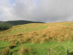
I headed across to where I had had my rest stop, and then back up to rejoin Glyndwr's Way as it skirted the flank of Pen Coed. As I climbed up I could see a pony silhouetted on a rock outcrop, looking magnificent as I approached, and seemingly unconcerned as I walked within a few feet of it. The walk across the rough ground was better than it had been earlier, if only because the best views were now in front of me, whereas they had been behind me when I had been walking in the opposite direction. As I looked behind me the pony had been joined by another one, and they were both standing on the rock outcrop, looking in different directions.
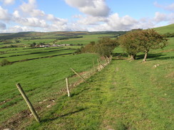
The rough ground ended too soon, and I was soon descending through enclosed land, cutting across the zigzags and joining the track that led back down towards the farm at Dolwen. It was a lovely walk and the views were superb, until eventually the path had descended enough to block out all of the views. I rejoined the road, and started following it back, still following Glyndwr's Way, as Tony Blair came on the radio for his final conference speech as Prime Minister. When I reached the point where Glyndwr's Way headed back uphill I decided to continue along the road, which slowly rose as it wound its way southwestwards, following the course of a burbling stream. The road was very quiet, and only a couple of cars passed me as I continued listening to the speech.
The road climbed slowly uphill towards an area of woodland. My route back to Llanbrynmair was to follow the old route of Glyndwr's Way before it was rerouted when it became a national trail. There were some signs still saying Glyndwr's Way - I found myself wondering if this might be confusing to walkers, and at the junction I stopped for a rest whilst I listened to the end of the Prime Minister's speech to conference. I took my boots off as I waited in the sunshine, enjoying the quietness that surrounded the spot. Eventually I headed on as the Way followed a track into the woods. This soon ended, and moss-covered waymarkers showed me the way through the trees. The last section headed through a dark gap between trees, before emerging out onto the hillside.
I headed west up a slight incline across rough ground, but I could not match the surrounding trees on the ground with the trees on the map, and it seems as though the boundaries of the woodland have moved slightly. Instead of trying to cross the fence and plunge through the trees I followed the edge, and at the top of a slight hill I found a stile across a fence about twenty yards away from the trees. I found a stile at a corner of the woodland, and I followed a series of helpful waymarkers through the trees. Eventually the path emerged from the trees, and the waymarkers disappeared. However I could see the cottage at Hafodowen near the bottom of the hill, and I followed a fence line down towards this.
At the cottage there were many dogs barking, and although they all seemed to be safely shut up I headed downhill along a good track. At a bend a waymarker on a post pointed up another track uphill, and although this looked slightly wrong I headed on. As I neared a bend at the top a four wheel drive car pulled up below and a woman got out. I descended down and she told me that I had gone wrong - a nail had come out of the waymarker and it had therefore tilted to point the wrong way. Thanking the woman I headed off down the correct track as it passed a new cutting and a barn to join a road.
The next stretch of path westwards was not very clear as it crossed some rough ground, but I managed to make my way past a small pond to a half-hidden stile. After this I went slightly wrong and started heading steeply downhill; to my right I could see the path that I had followed earlier up onto Cerrig y Tan, and as I knew the path I was following was supposed to join this, I climbed back uphill along a hedge and found the stile that allowed me to join the path. The walk back downhill was along the path that I had followed earlier and it was a surprise to find that I could not remember much of the walk; I had been so tired earlier that many of the views had not sunk in. Eventually the path reached the road, and I followed this the short distance back to my car in the car park at Llanbrynmair.
It was nice to be back at the car, and after throwing my boots off I got in and started the long drive over the hills towards Llangadfan. This was along the road that I had spent several hours along today, and it was a superb drive despite - or perhaps because of - the narrowness of the road. I pulled up in the car park outside the Cann Office Hotel and went inside - I was instantly made to feel very welcome, and I was soon shown up to my room.
The room is en-suite, and there is a nice, powerful shower situated in the room. I had a pleasant, warming shower and carefully washed all of the aching areas of my body, and then lay in bed, absolutely shattered and tired out. At about half past seven I went down to the bar, and ate a meal of ham, egg and chips with a side order of chips as I drunk two pints of Pedigree. The meal was delicious, with the ham coming in thick slabs, and the conversation with the others in the room was pleasant, as we chatted about walking and fly fishing (not that I know much about the latter topic). Just before I finished the meal a football team came in after practice and the atmosphere in the room became much more boisterous. I was feeling absolutely shattered, so I retired upstairs to my room and almost immediately fell into a deep sleep in the comfortable bed, a sign of how fatigued I was after the walk.
I am now a long way though the walk, and it is feasible to complete Glyndwr's Way with two more days walking; a loop walk tomorrow and a long one to Welshpool the day after (I will have to get a taxi back after that one). The alternative is to split the last day into two circular walks, but that will involve another day's walking, so the taxi option seems tempting at the moment.
 |
 |
|
 |
 |
|
Directions
|
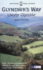
The walk is also covered in detail in the Glyndwr's Way National Trail Guide, by David Perrott, ISBN 1 85410 968 5, published by Aurum Press Ltd. Please click on the link to the right to access the Amazon page for the guidebok. The exception to this is the second half of the walk, from Llangadfan back south to Llanbrynmair. When Glyndwr's Way reaches the A458(T) in Llangadfan turn right, and follow it as it curves southwards for about a hundred yards, until the Cann Office Hotel is reached on the right. Here turn right, and follow a road as it descends to the south, soon crossing a bridge over the Afon Banwy and passing a caravan park on the right. The road curves to the right as it starts to climb uphill, before curving to the left by some houses. This road then climbs slightly, turning right a graveyard and chapel hidden in trees. It then climbs uphill with a white house on the right, and then when a road comes in from the right. The gradient slackens, and at a left-hand curve turn right, and head on, ignoring a road that comes in almost immediately from the right. This road continues to climb, before descending down to cross the Nant Nodwydd, and climbing up southwards on the other side. The road becomes a track as it continues to climb, before eventually ending at a cottage. Here go through a gate, and walk slightly south of west across pathless moorland to rejoin Glyndwr's Way on the flanks of Pen Coed. |
|
|
Continue along Glyndwr's Way as it descends southwestwards to the farm at Dolwen, and then joins the road that passes through Neinthirion and continues on. When Glyndwr's Way turns right to head uphill along a track, continue along the road as it follows the Afon Gam southwestwards. This is the pre-2002 course of the Way, before it was rerouted over the hills to the west. Eventually the road crossed the River Gam and passes a small farmstead at Ffridd Fawr, where it starts ascending southwards, the ascent slowly getting steeper as the road curves to the right. A patch of woodland is reached on the right; continue along the road beside the trees before turning right through a gate and adjacent stile to take a track that heads westwards through the trees. When the track ends follow the waymarkers through a clearing, and then up through a dark, narrow path through conifers before emerging out into a field. Here the waymarkers ended, and the route is uncertain due to forestry replanting. Initially I headed westwards across rough ground, but when the edge of woodland is reached I followed this northwestwards, with the trees on my left. At the top of a little ridge there is a fence; a gate and stile over the fence is a few yards away to the right, away from the trees. Once across the fence walk downhill, angling slightly to the left towards a stile that leads across a fence into the trees, at an angle in the treeline. Waymarkers head southwestwards for a couple of hundred yards across very rough, tummocky ground through a gap in the trees, before leaving the woodland over another stile. Once out of the trees head westwards across more rough ground along the top of a slight ridge. When a fence is reached, turn left and follow it down to a cottage at Hafodowen. Walk around the left-hand side of the house, and then join a track that heads downhill westwards, crossing a stream and rising slightly before turning left to follow a little gully down towards a barn. The track passes the barn and soon after ends at a road. Cross the road, and on the other side a footpath heads on westwards across a rough field, angling to pass immediately to the right of a pond before reaching a stile, hidden in trees at the hedge at the left-hand corner of the field. Cross this stile, and on the other side angle slightly to the right, skirting to the right of a barn and climbing slightly uphill to reach Glyndwr's Way on it's descent from the hills. From here, simply follow the Way as it descends downhill back towards Llanbrynmair. |
|
Distances
| From | To | Distance (m) | Ascent (ft) | Descent (ft) |
|---|---|---|---|---|
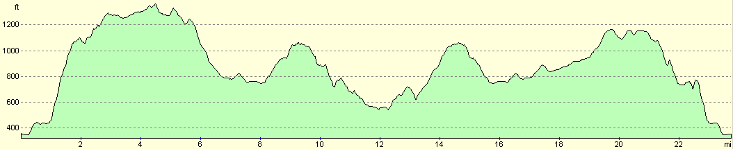
| Llanbrynmair | Neinthirion | 6.9 | 1335 | 899 |
| Neinthirion | Llangadfan | 5.3 | 574 | 804 |
| Llangadfan | Neinthirion | 4.7 | 764 | 535 |
| Neinthirion | Llanbrynmair | 6.9 | 778 | 1213 |
This makes a total distance of 23.8 miles, with 3451 feet of ascent and 3451 feet of descent.
For more information on profiles, ascents and descents, see this page
Accommodation
I spent the night at the Cann Office Hotel, which cost me thirty pounds for the night in a double en-suite room. This was a lovely place to stay, with several small bars and lovely food available at the bar in the evening, and a massive breakfast in the mornings. They can be contacted at the Cann Office Hotel, Llangadfan, Welshpool, Powys, SY21 0PL, telephone (01938) 820202, or email cannoffice@tiscali.co.uk.
Disclaimer
Please note that I take no responsibility for anything that may happen when following these directions. If you intend to follow this route, then please use the relevant maps and check the route out before you go out. As always when walking, use common sense and you should be fine.
If you find any information on any of these routes that is inaccurate, or you wish to add anything, then please email me.
All images on this site are © of the author. Any reproduction, retransmissions, or republication of all or part of any document found on this site is expressly prohibited, unless the author has explicitly granted its prior written consent to so reproduce, retransmit, or republish the material. All other rights reserved.
Although this site includes links providing convenient direct access to other Internet sites, I do not endorse, approve, certify or make warranties or representations as to the accuracy of the information on these sites.
And finally, enjoy your walking!
This walk was mentioned in the following routes:
| Glyndwr's Way |
Nearby walks
| # | Title | Walk length (miles) |
|---|---|---|
| 741 | Glyndwr's Way: Llwynygog to Forge | 18.9 |
| 742 | Glyndwr's Way: Forge to Llanbrynmair | 15.1 |
| 744 | Glyndwr's Way: Llangadfan to Dolanog | 15.8 |
|
|

|