Walk #742: Glyndwr's Way: Forge to Llanbrynmair
 |
 |
|
General Data
| Date Walked | 25/09/2006 |
| County | Powys |
| Start Location | Forge |
| End Location | Llanbrynmair |
| Start time | 09.00 |
| End time | 16.35 |
| Distance | 15.1 miles |
| Description | This was an enjoyable stroll following Glyndwr's Way eastwards, with some superb views available over the hills to the north. |
| Pack | Today I carried my 30-litre Karrimor rucksack filled with my waterproofs, three litres of water, and various other odds and ends. |
| Condition | My chaffing was not as bad as it was yesterday, and although it made itself known it was not too bothersome. I have some significant sweat rash around the tops of my socks, and one patch on my right ankle is particularly bad and sore. The problem with my left Achilles that I had yesterday has been perfectly fixed by the Compeed plaster that I put on it. |
| Weather | The day was generally bright and sunny, with a fair amount of cloud blocking the sun out on occasions. It was a warm day, and there was none of the stiff breeze that there had been over the last couple of days. |
| OS map | Landranger number 135 (Aberystwyth & Machynlleth) and Landranger number 124 (Dolgellau & Porthmadog) |
 |
 |
|
 |
 |
|
Map of the walk
Maps courtesy of Google Maps. Route for indicative purposes only, and may have been plotted after the walk. Please let me have comments on what you think of this new format. For a detailed table of timings for this walk, please see the table file.
 |
 |
|
 |
 |
|
Notes
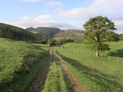
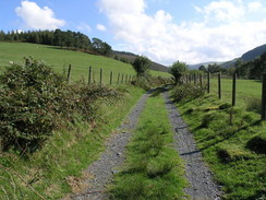
It was nice to be able to start this walk from the B&B, and after another hearty breakfast and friendly conversation I got changed into my walking clothes. I was on the road by nine, and the first stretch of the Way followed a road that led uphill virtually from the front door of the B&B. When this curved to the left a track continued straight on, and this took me over wet, dew-sodden grass towards the farm at Pen-rhos-bach, which it diverted around before descending slowly, passing another farm before joining a road that shortly led to the A489(T) in Penegoes.
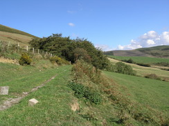
The Way followed the road eastwards through the small village, before heading out along another road. There were some new houses being constructed beside the path, and it looks as though these will increase the size of the village considerably. When the road diverted to the left to visit Maesperthi a concrete path continued up for a couple of hundred yards until another track was reached, and this continued eastwards up a slight gradient near a gully carrying the Nant Seli. The track was a pleasant walk along a slight gradient, but eventually the Way left this and struck straight up the hill to the left, climbing steeply before the gradient slackened.
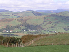
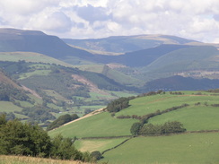
The path changed to the other side of the fence by crossing the corner between four fields on a ladder stile, the fence and stile both looking new. What followed was a very pleasant walk along a bracken-lined path, with some great views to the north and west, and as I walked along the sound of jet fighters flying low assailed my ears. A few passed without my spotting them, but I then saw a Tornado pass by relatively nearby and below me. A few minutes later another Tornado flew by low, and it was followed by two Eurofighters, their distinctive triangular plan forms not following the Tornado through the valley but abruptly changing direction and heading up into the sky.
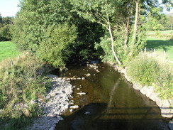
It was a really enjoyable walk along the path and the gradient was relatively flat, but then came three gullies that had to be traversed. On one of these it was difficult to see the exact route, as the path was covered in bracken but I was soon starting the long descent down towards Abercegir. On the way there were apples that had been blown off a tree, and as my feet crunched them I got an absolutely delicious aroma wafting up towards me. The route through the village was slightly convoluted, dropping down to a footbridge over a stream before climbing up past what looked like an old mill to reach another road; seemingly the main road. There were some fairly pretty houses around, but I did not get to see much of these as the path almost immediately headed out of the village along another road.
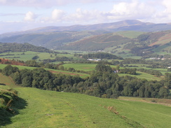
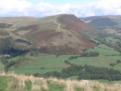
A track headed off this road for a few yards before a footpath led off to the left, skirting the hillside before starting to climb steeply uphill. This was a bit of a puff, and the gradient did not slacken much until a track was reached, which led me around the flanks of the hill of Rhos-y-Silio. Now that the height had been regained there were some more good views to be had over towards Cadair Idris, and yet more jets passed by as the RAF seemed to be out playing in force. What followed was a superb walk eastwards along the top of a ridge, and I found myself really enjoying the trip. Eventually the path reached a road, and the Way turned down this for a few yards before diverting off to the right along a path. The first field that this entered was full of small cabbage plants, and the moisture on these soon had my trousers and boots sodden. This made the last mile of the descent uncomfortable, and it was a relief when the Way joined a track beside three tractors in various states of disintegration.
The track ended at a road, and I headed down this to a roundabout in Cemmaes Road. The Way turned right here to head along the A470(T) eastwards, but instead I turned left and walked down into the village in order to visit the pub and post office marked on the map, although I did not hold out much hope for the former being open. My impressions were wrong, however, and the post office was shut and the pub - in the Dovey Valley Hotel - was open. I ended up chatting ton the landlord (who has had that job for forty years) for a while whilst I drunk a pint of bitter and another of orange and lemonade. I enquired about busses, and like a star he produced a bus timetable for busses from LLanbrynmair to Machynlleth, and I was glad to see that there was one a little after five, which gave me plenty of time for the next part of the journey. I therefore took an extended lunch break, and bade goodbye to the landlord before heading back onto the road.
I rejoined the Way at the roundabout and followed it as it descended to cross the Afon Twymyn on a bridge. Immediately beyond this a driveway led off to the right, skirting the northern side of the river and giving a good view of a railway bridge over it. The driveway soon became a flint track that was relatively level as it headed southeastwards, eventually turning to the left and starting to climb along the western side of a gully. About halfway up this the Way left the track, taking a green lane that rose before descending slightly to skirt the top of the gully, and then climbed upwards once more. As it climbed the views became even better, and after the Way passed a farm it continued to rise at it skirted a great arc around Commins Gwalia. The path entered an area of bracken after it left the enclosed land, and then started to descend down to meet a road.
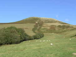
The road headed south before a track led off to the left, heading east as it slowly climbed to meet another road. On the other side of this another track led on, heading east once more as it climbed up the southern flank of Moel Eiddew, the windfarm on the summit now being out of sight. The path ran along a slight ditch between the field boundary and the hillside, and consequently it was damp and boggy in places, and I slowed down as I tried to negotiate the worst patches. Once this stretch ended at a gate beside an old, seemingly abandoned tracked tractor, I joined the track on the other side and sat down. There was plenty of time left before the bus, and the views were so enticing that I stopped for twenty minutes, looking at the clouds blow slowly across the sky and listening to the deep, thudding booms of the RAF playing around in the skies around.
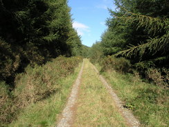
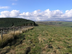
Eventually I set off once again, following the track as it slowly rose to enter some coniferous woodland. Unlike the woods that I had passed through yesterday this was relatively light and airy, with some greenery around the sides of the track. It rose gently and I could walk without stopping, before the Way left the track by turning right to head through a darker area of trees for a few yards until the edge of the trees was reached. The Way then turned to climb uphill along the edge of the trees, soon reaching a cleared area where the stumps and loose branches lay on a near-sterile ground. Once this area ended the path started to descend across some superb moorland, slowly descending as I admired the views all around.
The path left the moorland after a short distance and entered some enclosed land, following the brow of the hill steeply down towards a transmitter. Here a track led on, still descending steeply, the gradient eventually slackening as a farm is reached. The farm was littered with an unsightly pile of car batteries, before another track led to another farm and a road.
The road headed down from the farm, but I started to get confused when it curved to the left to start heading in a more easterly direction. This stretch of road was not marked on the map, but there were signposts for the Way pointing in the direction and so I followed it, curious about the new tarmac under my feet. The road soon reached what looked like a brand new bridge over the Afon Rhiwsaeson, after which it ended at a minor road. As this is not marked on the map I assume that they have closed the old road that passed under the railway line, and it is a shame that the Way now does not visit the village of Llanbrynmair.
The road passed under a large railway bridge before reaching the A470(T) by the Wynnstay Arms. Opposite I could see a bus stop, and beyond that a large car park, which was a relief as it means that there is somewhere convenient to park for tomorrow's walk. The bus turned up on schedule at around six minutes past five, and I boarded a bus that was half full of schoolchildren for the twenty-minute journey. Once in Machynlleth I went into the CO-OP to buy some apples, and then started the mile-long walk back to the B&B.
After I had had a shower I decided to go into town to have a meal, especially as I had decided to leave early in the morning without a breakfast - this will allow me to leave much earlier, and start what promises to be a long walk at a much more convenient time. It is a shame as the breakfasts here have been very good, but the opportunity to start the walk an hour earlier is too good to miss. When I got to my car it would not start, the engine stalling on the first attempt and not much better on the second. On the fifth attempt it stopped stalling, and after I saw that it was running smoothly I reversed out of the driveway and headed down into town. I did not fancy visiting the café for a third night in a row (anyway, it was closed on Monday nights), and so I went to a pub where I had a lovely meal of chicken breasts in a leak and cream sauce - superb.
I can now complete Glyndwr's Way in three days if I want, and so as the weather is forecast to be fairly dismal the day after tomorrow I may take that day off and go sightseeing in the local area. So far this trip has gone quite well, and I can only hope that the rest of the trip will continue in a similar manner.
 |
 |
|
 |
Directions
|
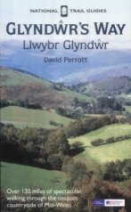
The walk is also covered in detail in the Glyndwr's Way National Trail Guide, by David Perrott, ISBN 1 85410 968 5, published by Aurum Press Ltd. Please click on the link to the right to access the Amazon page for the guidebok. |
|
Distances
| From | To | Distance (m) | Ascent (ft) | Descent (ft) |
|---|---|---|---|---|
| Forge | Penegoes | 1.3 | 180 | 125 |
| Penegoes | Abercegir | 2.5 | 617 | 561 |
| Abercegir | Cemmaes Road | 4.0 | 837 | 899 |
| Cemmaes Road | Llanbrynmair | 7.3 | 1683 | 1476 |
This makes a total distance of 15.1 miles, with 3317 feet of ascent and 3061 feet of descent.
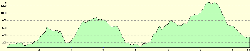
For more information on profiles, ascents and descents, see this page
Accommodation
I spent the night at a B&B called Cwm Dylluan, at Forge near Machynlleth, They can be contacted on (01654) 702684, and they are located at SN 764999, This very smart B&B cost me thirty pounds for the night, for a double non-ensuite room.
Transport
There are about four bus services a day from Llanbrynmair to Machynlleth, at a cost of Ł2.30 for a single journey. An equivalent taxi ride will cost around Ł17.00.
Disclaimer
Please note that I take no responsibility for anything that may happen when following these directions. If you intend to follow this route, then please use the relevant maps and check the route out before you go out. As always when walking, use common sense and you should be fine.
If you find any information on any of these routes that is inaccurate, or you wish to add anything, then please email me.
All images on this site are © of the author. Any reproduction, retransmissions, or republication of all or part of any document found on this site is expressly prohibited, unless the author has explicitly granted its prior written consent to so reproduce, retransmit, or republish the material. All other rights reserved.
Although this site includes links providing convenient direct access to other Internet sites, I do not endorse, approve, certify or make warranties or representations as to the accuracy of the information on these sites.
And finally, enjoy your walking!
This walk was mentioned in the following routes:
| Glyndwr's Way |
Nearby walks
| # | Title | Walk length (miles) |
|---|---|---|
| 396 | Aberystwyth to Cwrt | 19.9 |
| 397 | Cwrt to Fairbourne | 22.3 |
| 741 | Glyndwr's Way: Llwynygog to Forge | 18.9 |
|
|

|