Walk #741: Glyndwr's Way: Llwynygog to Forge
 |
 |
|
General Data
| Date Walked | 24/09/2006 |
| County | Powys |
| Start Location | Llwynygog |
| End Location | Forge |
| Start time | 09.31 |
| End time | 18.20 |
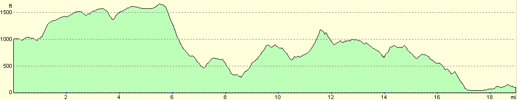
| Distance | 18.9 miles |
| Description | This was very much a walk of two halves, with a spectacular high moorland walk to Foel Fadian being followed by a long walk that rose and fell mainly through enclosed land, with some superb views over towards Snowdonia. |
| Pack | Today I carried my 30-litre Karrimor rucksack filled with my waterproofs, three litres of water, and various other odds and ends. |
| Condition | My left knee ached at times, but it never grew to be pain. I have some significant chaffing, and my left Achilles has been bleeding from rubbing. |
| Weather | The day started off cloudy, but by mid-morning this had lifted and the day was mostly a mixture of sunshine and cloud. It was a warm day, and there was not much of a breeze to help keep me cool. |
| OS map | Landranger number 135 (Aberystwyth & Machynlleth) |
 |
 |
|
 |
 |
|
Map of the walk
Maps courtesy of Google Maps. Route for indicative purposes only, and may have been plotted after the walk. Please let me have comments on what you think of this new format. For a detailed table of timings for this walk, please see the table file.
 |
 |
|
 |
 |
|
Notes
The breakfast this morning was hearty and filling, and I had half an hour to get ready before the landlord of the B&B was to drive me to the start of the walk. We had to shuffle the cars so that he could get his out, but before I knew it we were heading up the mountain road towards Llwynygog, where I had left the Way yesterday. On the way we stopped off near the summit of the drive to visit a memorial to a Welsh writer; the memorial was built here as it was apparently his favourite spot. The drive down past the pub at Dylife went quickly, and I was soon jumping out of the 4x4 and tying my shoelaces ip.
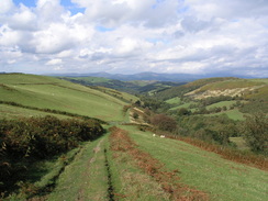
A very short walk took me to the point where I had left Glyndwr's Way by Llwyn-y-gog Farm, and a nice level path took me northwards across a few fields. The path met a track at a bridge over the Afon Clywedog (the river that feed the large reservoir that I walked past yesterday), and the first climb of the day started past the farm at Felin-newydd. A sunken green lane led steeply upwards, and overhead the clouds were low, and it seemed as though I would soon be in them. The climb was making me very hot, so I decided to take my coat off, hoping that I would not have to put it on again anytime soon - a hope that thankfully came true as the base of the clouds lifted before I reached them.
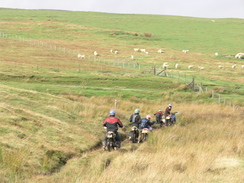
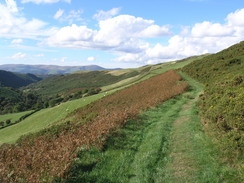
At the top of the green lane a path led on across a field, still climbing, before a drover's track was reached along another green lane, heading northwestwards. In places the track had been literally cut out of the ground to make it level, and the local slate-like rock protruded in large clumps. This was a very pleasant stretch of walk, and the relative levelness across the site of the Roman Fortlet on top of Penycrocbren allowed me to make good time. There was not much to see of the fort aside from a few low mounds, which may not have had anything to do with the Romans. Behind me I could see a light in the distance, and as I approached a TV aerial (a strange sight seemingly in the middle of nowhere) five motorcyclists came past me. They overtook me, but a short distance on I came across them - a couple were standing around, looking at one of them who had appeared to stall his bike right in the middle of a large and seemingly deep puddle in the track.
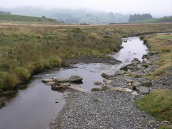
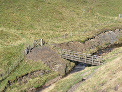
The Way joined a track for a short distance before joining a path and gently climbing once again, and I got some good views over the hills to the north. It was another enjoyable stretch of walk, but as the path started to slowly fall a large gully appeared on the left, and I realised that I would soon have to negotiate it. The path reached a point at the top of the gully where it seemed to disappear; on the other side I could see a barn and the path climbing steeply, but there was no sign of the path down or the footbridge that the guidebook said led over the stream at the bottom (the infant Afon Clywedog). The path down proved easy to find and was easy to descend over bare, fractured rock, and once across the bridge I ascended up towards the barn over a larger expanse of fractured rock.
After the barn the gradient slackened and a track led onwards to the northwest, passing the remains of a mine that was nowhere near as spectacular as the one at Bryntail that I had passed yesterday. A little further on the remains of a dam over the Nant Ddu became visible on the left, the dam having been purposefully breached many years before, leaving just the grassed-over substantial remnants behind. I could not help but wonder what the area would have looked like with the small reservoir behind the dam, and I felt that it may have enhanced the scenery. The Way left the track soon afterwards, and started heading across some boggy moorland of the type that I love. The walk was very enjoyable but the path on the ground was indistinct (in one particularly boggy patch two waymarkers were lying in the mud, seemingly to act like stepping stones).
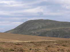
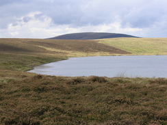
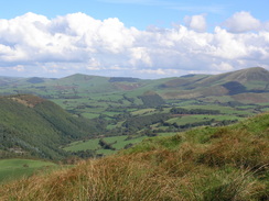
The path reached an unsurfaced track, and the Way then followed this towards the lake at Glaslyn. This looked magnificent when the sun was out, and I stopped to take a panoramic photo before moving on. Ahead of me was the summit of Foel Fadian, and I could make out the trig pillar standing proud on the skyline. I really wanted to climb up and visit this as it did not seem to much of a climb from the path. The Way left the track and headed up a slight incline over rough ground towards the pillar, but when it turned sharply to the left to start the descent I decided against the extra climb - I had a feeling that I would need the energy for later on in the day.
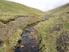
Soon afterwards the descent started, and it proved to be quite hard going. My left knee was aching on every step, and the path underfoot comprised of slippery slate rock. Fortunately for most of the way it was angled upwards, which meant that my feet could get good purchase, but on occasion I had to be very careful not to slip. At a junction in the paths the Way turn to the left, crossing a pretty stream before starting to zigzag downwards steeply, along what was by now more of a track than a path. The gradient started to slacken when the path entered enclosed land, although it was still a steady descent, with the Nant Fadian flowing in a gully to the right. It was an enjoyable descent, the only downside being my aching left knee, which the knee brace that I was wearing did not seem to help.
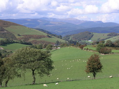
The track passed a caravan site in what has to be a fairly hard to access location, and then passed Nantyfyda Farm at the apex of a hairpin bend. Here it joined a surfaced road that headed downhill around another sharp bend, before turning off to the right along another narrow road that headed steeply uphill. I could not really see the point of this climb as I knew that the path would soon descend once again, but I gritted my teeth and powered my way up, my left knee giving me no problems on the ascent. The Way left the road and a track took me northwestwards, curving around with some superb views to head to the southeast.
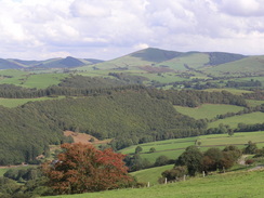
The views petered out as the path started to descend quite steeply, joining a road that allowed me to make good progress as far as the bridge over the stream at Felindulas. The road headed steeply up from the bridge and I was soon puffing for breath, but the road turned to the left for a short distance at a reduced gradient that allowed me to recover before it curved once again and climbed steeply up to the farm at Cleirau-isaf. As soon as I entered the farmyard a collie dog was barking around my heels, and it continued to do so until the very moment that I left the farmyard and continued on uphill. The climb was again steep, but the effort was rewarded by some superb views over the hills to the north, and I was fairly sure that a pyramid-shaped mountain on the skyline was Snowdon.
The path continued to climb as it became a cycleway, and the views continued to be good. Just before it plunged into some trees I stopped for a rest, and ate my remaining apple and half a pack of nuts and raisins. I was getting through my water much faster than I expected, and I was fairly sure I would be running out before the end of the day. I put this to the back of my mind, and after twenty minutes of admiring the views I put my boots back on and continued along the path, which immediately plunged into some woodland before descending to reach the B&B at Talbontdrain.
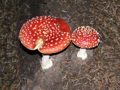
A road led uphill from the B&B towards a farm, and then a path started climbing uphill, the gradient becoming increasingly steep as the rutted track headed to an area of woodland. Reaching the woodland did not mean the end of the exertion, as the path climbed up alongside the tree line before eventually entering. What followed was a steep and dark descent through the woodland down a Mountain Biking route called 'The Chute'; the coniferous woodland was very dark and on the ground there was no greenery, a thick mat of pine needles covering everything. It was dark and gloomy, and there were many mushrooms growing in places.
As I reached the bottom I realised that I had not seen any other walkers all day; the route had been exceptionally quiet. As if on queue, two mountain bikers came past me, their brakes squealing as they tried to stop in time for the gate at the bottom of the woodland. Once out the path climbed once again before starting on a relatively level contouring along the side of the valley. This was another enjoyable stretch, and in the distance I could see a few other walkers making their way along the hillside. To my left on the other side of the valley there was a patch of woodland, and zig zagging through this was a track that was not marked on my map. The track continued high onto the flanks of Foel Fras. In the forest I could see the remains of an older set of zigzag tracks, so I wondered if this could be an access road to a windfarm, although there were no turbines visible.
Near the end of this stretch I came across three ladies sitting on an outcrop of rock eating some food, and it turns out that they were the walkers that I had seen half an hour earlier. They were walking the Way in stretches over the weekend, and had set off from Aberhosan earlier in the day. We chatted for about fifteen minutes, and as they got ready to set off once again I headed off, with them following closely behind. The Way descended into a valley before climbing up once again to head towards a coniferous forestry plantation. The path on the ground was indistinct and I did not gain enough height, so I had to climb steeply up the hillside to find the gate that led into the woodland.
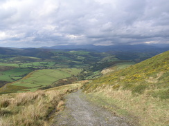
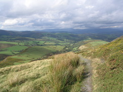
Again this was a dark walk, with little greenery to be seen and a few occasional outcrops of mushrooms scattered around the forest floor. The track headed arrow-straight through the trees, rising and faling gently as it did so. The sunlight that greeted me once the track left the trees was nearly blinding, and the track started heading westwards along the top of a valley side. Occasionally I got glimpses of Machynlleth far below me, but the walk itself was enjoyable, although I was starting to get increasing problems with chaffing and my left heel, which felt as though it was bleeding (an injury I have had on a few occasions recently).
The track curved around a little valley before reaching the farm at Bryn-glas, after which the track started to descend before meeting a surfaced road. The Way followed this steeply downhill for a period before turning off to the right, passing some pretty white cottages before heading steeply downhill. At one point there were some steps cut straight out of the slate; these are apparently called the Roman Steps, but I doubt that they are that old. As I descended the noise of the traffic blow got louder, and this was something that sounded strange to my ears after such a remote and quiet walk.
At the bottom the Way touched a road for a few yards before heading through a set of large and imposing gates into the grounds of Y Plas, a lovely stately home (the ex country seat of the Marquis of Londonderry), pleasantly covered in a creamy yellow paint. Next to it was a large slab of slate that commemorates Owan Glyndwr, and I walked around this before heading on past a slate-roofed leisure centre that contrasted sharply with the stately home behind.
The Way entered Machynlleth via a pair of grand gates, with a pair of stone gatehouses on either side. Opposite was an attractive wooden framed building, and it was a superb way to enter the main area of the town. I was very thirsty by this time, and so instead of turning right to head towards the B&B I turned left to find somewhere to eat.The first pub that I reached, the White Horse Hotel was busy and noisy and outside there was a sign stating that there was no food, so I walked down the street for a few yards to reach the caf� that I had eaten at last night. I order fish and chips and sat down, knowing that if I ate now I would not have to drive into town this evening, and the food soon arrived. I ravenously devoured it, and whilst the chips were not the nest the food was absolutely superb. I had also ordered a glass of orange and a glass of iced water, and these helped wash down the food and quenched my thirst somewhat.
Once I had finished I quickly left and started walking towards Forge along the road; by now the chaffing was starting to get very annoying, and as the road left the town I was greeted with the sight of the hills to the right that I had walked along an hour before, and a footpath leading down from them. The Way makes a little loop into Machynlleth, and although this would be fine if the day's walk ended in the town, it just seemed unnecessary for me, given the endpoint of the day's walk. I soon crossed the bridge over a stream and with relief reached the B&B, and rarely has a place of accommodation seemed so welcome.
This was a very long and tiring walk,and I am surprised that it took me so long to complete - it was about three miles shorter than yesterday's walk and had about 800 feet less ascent (although slightly more descent), but it took me twenty-five minutes longer. When I was on the flat I kept up a good speed, and I do not think that me knee affected me too much, so I wonder if I was just more tired today. Also the terrain was harder today, as the last half of yesterday's walk had been along roads.
Tomorrow I am planning to do a short fourteen mile stroll to Llanbrynmair, and although it is short it will have about as much ascent as today's walk. This will put me a day ahead of schedule (of my planned circular walks), and this will give me some leeway to take a day off before the end of the walk. The only problem is that it will be a one-way walk, and I have yet to organise exactly how I will get back from Llanbrynmair when I have finished in the afternoon - a taxi or hitch hiking may be the best bets.
 |
 |
|
 |
 |
|
Directions
|
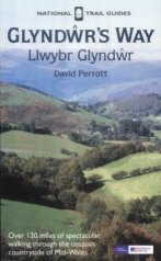
The walk is also covered in detail in the Glyndwr's Way National Trail Guide, by David Perrott, ISBN 1 85410 968 5, published by Aurum Press Ltd. Please click on the link to the right to access the Amazon page for the guidebok. |
|
Distances
| From | To | Distance (m) | Ascent (ft) | Descent (ft) |
|---|---|---|---|---|
| Llwynygog | Glaslyn | 4.8 | 1030 | 453 |
| Glaslyn | Talbontdrain | 5.8 | 1079 | 1985 |
| Talbontdrain | Machynlleth | 7.1 | 1332 | 1962 |
| Machynlleth | Forge | 1.2 | 161 | 102 |
This makes a total distance of 18.9 miles, with 3602 feet of ascent and 4502 feet of descent.
For more information on profiles, ascents and descents, see this page
Accommodation
I spent the night at a B&B called Cwm Dylluan, at Forge near Machynlleth, They can be contacted on (01654) 702684, and they are located at SN 764999, This very smart B&B cost me thirty pounds for the night, for a double non-ensuite room.
Panorama
Click on the image below to get a larger image (warning: size 11.5MB)
Click on the image below to get a larger image (warning: size 20MB)
Disclaimer
Please note that I take no responsibility for anything that may happen when following these directions. If you intend to follow this route, then please use the relevant maps and check the route out before you go out. As always when walking, use common sense and you should be fine.
If you find any information on any of these routes that is inaccurate, or you wish to add anything, then please email me.
All images on this site are © of the author. Any reproduction, retransmissions, or republication of all or part of any document found on this site is expressly prohibited, unless the author has explicitly granted its prior written consent to so reproduce, retransmit, or republish the material. All other rights reserved.
Although this site includes links providing convenient direct access to other Internet sites, I do not endorse, approve, certify or make warranties or representations as to the accuracy of the information on these sites.
And finally, enjoy your walking!
This walk was mentioned in the following routes:
| Glyndwr's Way |
Nearby walks
| # | Title | Walk length (miles) |
|---|---|---|
| 396 | Aberystwyth to Cwrt | 19.9 |
| 397 | Cwrt to Fairbourne | 22.3 |
| 740 | Glyndwr's Way: A circular walk from Llanidloes to Staylittle | 22.2 |
|
|

|