Walk #740: Glyndwr's Way: A circular walk from Llanidloes to Staylittle
 |
 |
|
General Data
| Date Walked | 23/09/2006 |
| County | Powys |
| Start Location | Llanidloes |
| End Location | Llanidloes |
| Start time | 09.31 |
| End time | 17.55 |
| Distance | 22.2 miles |
| Description | This is a walk of two halves; the initial half follows Glyndwr's Way as it winds past the Llyn Clywedog Reservoir, and the second half follows quiet roads back to Llanidloes. |
| Pack | Today I carried my 30-litre Karrimor rucksack filled with my waterproofs, three litres of water, and various other odds and ends. |
| Condition | My left knee started giving me trouble about two-thirds of the way through this walk, and this is quite a worrying development. Aside from this I feel fine; I have no blisters and no chaffing, which is good considering it was a long walk and there was about 4,400 feet of climb during the day. |
| Weather | The day was quite warm for late September, and most of the day was spent in bright sunshine with patchy clouds overhead. It never threatened to rain, although the brisk wind blew the clouds along at a fair pace. |
| OS map | Landranger number 136 (Newtown, Llanidloes & surrounding area) |
 |
 |
|
 |
 |
|
Map of the walk
Maps courtesy of Google Maps. Route for indicative purposes only, and may have been plotted after the walk. Please let me have comments on what you think of this new format. For a detailed table of timings for this walk, please see the table file.
 |
 |
|
 |
Notes
I spent last night at may parents' house in South Derbyshire, which allowed me to break up what would have been over a four hour journey from Cambridge into something a little more manageable. I got up at six and was on the road by seven, the journey taking me slightly longer than I had planned, and it was about nine twenty by the time that I finally pulled up into a car park in Llanidloes. I was unsure where I was in the town, and so after I had paid two pounds to park I put all my kit together and headed off down the road, to find myself after only a couple of minutes at the Mount Inn, where I had finished last year's walk ignominiously.
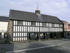
Llanidloes was as beautiful as I remembered it, with what has to be one of the prettiest NatWest banks anywhere, housed in a half-timbered building, and a market hall with an open ground level. It felt nice to be back, and I stopped off at the NatWest to get some money from the cashpoint before continuing down the road. At the time of the morning the town seemed to have not yet fully woken up, and the streets were quite quiet. The road led down to a roundabout and then to the bridge over the River Severn, which seemed to be glowing in the low sunshine. The way headed along a road for a few yards before turning left along the B4518, which in turn headed uphill. At one point there was a row of houses at right angles, the rear alley being covered over between the houses and the adjacent bank.
The Way soon left the road, and started a steep puff up to the woodland at Allt Goch, the path also taking the Severn Way for a short distance. The walk through the woodland was pleasant, but the steepness of the climb took my mind off most of the views. I found myself being very glad that I was not carrying a full camping pack today, a thought that would come back to me increasingly as the day progressed. The path soon levelled off and the woodland made the walk feel quite remote, so it was a surprise when I saw some immaculate golf course greens off to me left. The path left the woods and passed the golf course club house, where it turned down a road before joining a track.
I really did not want to lose the height that had been so hard won, and so I found the next descent to be annoying, heading across enclosed land and crossing many field boundaries and a road before hitting the top of a steep drop of a small disused quarry. The path was unclear on the ground and I thought that the quarry might be one that was further west on the map and that I was out of position, so I followed a hedge east for a couple of hundred yards until I reached a stream. This told me that I had been totally wrong, and so I headed back and found a stile right under the small cliff face.
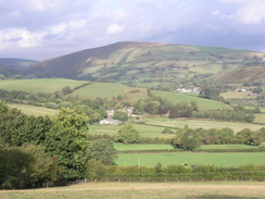
The path headed down to cross a road near the village of Van, and I realised that if I took my planned return route that I would be passing this point again. A track headed up from the road, but the path soon left this and headed uphill, joining a track that climbed up onto Garth Hill. There were some nice views from here over the lake of LLn y Fan immediately to the north, but these did not last long as once again the path started to descend along a wide hedged track, which was left as the path descended downhill to meet the B4518 road.
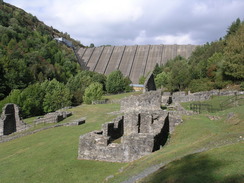
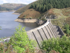
Initially the road descended to a junction, before climbing steeply to a summit where there were some more good views over the lake, which by this time was much lower to the east. Just after the summit the Way left the road and a long track led on to Bryntail Farm, and then on past some spoil heaps from lead ore workings. The track then approached a patch of woodland, and here I got my first views of the massive concrete Clywedog Dam, a spectacular stepped structure that dominated the view. I was so enthralled that after crossing the stile my right foot twisted slightly as it went over the edge of the track. It was not too bad, and I walked on as the path wound steeply down the hillside before approaching the ruins of Bryntail Mine.
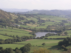
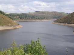
The remains of the stone buildings were all ruinous but seemed to be very well looked after, and I felt that they were quite magnificent, particularly with the sight of the dam visible nearby. I wanted to stop and explore, but I still had a long way to go and so I pressed on along a wide footbridge. Another climb started, initially along a track that became a road at some houses. At the top of this climb I was pleased sot see a sign for a caf�, and so I strolled down to this. After using the toilet I bought a bottle of water, a little carton of orange juice and a lovely sloppy ice cream, which I wolfed down as I approached a bend in the road from where I got some superb views down over the top of the dam and the reservoir. This was quite low, and steep-sided banks had been revealed by the low water levels. The sun was shining through gaps in sparse clouds overhead, and I walked slowly along the raised stone viewing platform beside the single-track road, allowing the views to sink in.
A plaque on the viewing platform stated that it is a round headed mass concrete buttress dam, which at the time of completion in 1967 was the tallest dam in the British Isles. It was built to improve and regulate the flow of water in the River Severn, and to reduce flooding in the upper river valley. It is 235 feet high and 752 feet long, with a maximum depth of 212 feet. 11,000 million gallons of water are impounded, and the reservoir behind it is six miles long, with a catchment area of 18 square miles. Construction started in the 6th April 1964, and the impounding was completed on the 22nd December 1966, which I thought was a surprisingly short period for such a large construction project. The dam is an amazing structure, and certainly imposes itself onto the valley.
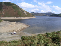
Shortly afterwards a hairpin bend in the road was reached, and here the Way left the road and headed directly uphill, another steep climb that soon had me sweating. At the top it met a road, and there were some good views over the reservoir as it descended. These continued as the path left the road, angling back down towards the reservoir. The Way entered a narrow and overgrown path between a hedge and a fence, bracken blocking visibility of where I was putting my feet. Suddenly my right leg shot down into a hole and I tumbled over into the vegetation. Swearing, I pulled myself up to find that I was unhurt, but I started cursing the way that the path was so overgrown. Fortunately the vegetation soon ended and the path became easier to follow as it angled towards an inlet in the reservoir, which I was surprised to find was essentially dry, aside from a small stream running down the middle. The water levels were so low in the reservoir that this inlet was dry, and there were several boats that had been left and dry on the banks.
The path angled around the inlet and there were some pleasant views to be had, and once on the other side it joined a road that passed a sailing club. As I passed over a cattle grid I saw movement a few yards away in the field to my right, and I looked over to see an otter looking back at me. I stopped dead in my tracks and stared at the otter, and it in turn just stared at me. It was only the second or third time that I have seen a wild otter during a walk, and I was absolutely mesmerised by the sight, and it was truly one of the highlights of the day.
What followed next was a fairly annoying stretch of path that climbed and fell, sometimes being indistinct and at others fairly easy to follow. Although the views over towards the reservoir were pleasant the climbs were starting to annoy me, especially when the final descent back towards the water began. At one point I saw a fish farm at the side of the reservoir, the first time that I have seen a fish farm since I was on the West Coast of Scotland a couple of years ago, and a good sign that this reservoir is not used to provide drinking water.
The path crossed a road before starting to climb once again as it started to head inland along a bridleway, initially zig-zagging before settling down as it approached some woodland, with a stream to the right. The path crossed the stream at a pleasant spot before entering the woodland for a short distance as it climbed once again through the trees, soon entering a clearing and following the edge of the trees and climbing up to meet as track.
On the map this track led through some woodland, but the trees on the left had recently been cut down, the remnants of branches and stumps still littering the hillside, and the ones on the right being only a few years old. Once the path exite the woodland it started to descend across some fairly boggy ground, and the squelchy terrain underfoot made me quite glad when the Way joined a track. This too was soon left, and the path angled towards a stream before ending at a road near to a bridge over a stream. The Way crossed the stream via the bridge, and then immediately on the other side joined a footpath that headed steeply uphill through a woodland. It was a pleasant walk, but I was relieved when it joined a road and the gradient slackened.
The road led on northwards through the woodland, exiting shortly before dropping down to Dolydd. I passed this and started to look for somewhere to potentially park my car before tomorrow's walk, but there was nowhere obvious and so I walked on as the road crossed a bridge over a stream. Shortly afterwards the Way left the road and joined a track that headed up towards the far at Nant-yr-hafod; before this was reached it left the track to make a large loop up the hillside to the left. This was annoying and involved a slight climb, and I was relieved when the path got onto the level once again and started heading northwards towards Llwyn-y-gog Farm.
This was the point where my route for the day left Glyndwr's Way, and I took a track that led the short distance down to a road. This led me northeastwards past the little hamlet of Llwynygog, before reaching the B4518 once again. I carefully followed this southeastwards past a pretty chapel on the right; the road was not too busy but the vehicles did come along fairly fast. At the point where the road to Staylittle left there was a bench, and I gladly used the opportunity to sit down and take my boots off. I was feeling fairly positive about the day; I had no significant aches or pains, and the new socks that I was using seemed to be protecting my feet fairly well.
A road sign opposite me said that Llanidloes was only seven miles away via the main road, and I knew that the route that I had chosen to take was a couple of miles longer. It was tempting to take the shorter route, but although the road seemed to be fairly quiet it did seem to be fairly winding on the map, and so I decided that it was probably best to take my planned route. After ten minutes I put my boots back on and started heading uphill, almost immediately coming across a Pot Office. It was open, and I chatted to the man running it whilst I bought a bottle of Lucozade, a carton of orange and two apples. The shop was fairly well stocked for such a rural area, and I can imagine that it is a lifeline for all of the people who live locally.
Freshly provisioned I walked on as the road climbed steeply uphill to the east. At a road junction I turned off to the left along a narrower road and the gradient soon flattened out, and there were some superb views to be had, with a windfarm visible in the distance to my left and another to my right. I recognised the latter as being the one that had dominated the views on the walk into Llanidloes last year. The turbines were rotating and it was no wonder - the wind was fairly strong, and I was starting to get slightly chilly as I walked along on the exposed location. This changed as soon as the road started to descend, and I was feeling really good - I happily noted that I had no significant problems, and this was obviously tempting fate, as when the road started to wind around as it steeply descended my left knee started to ache in protest.
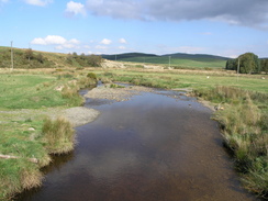
As soon as it started aching I realised that it was significant and not just a temporary ache, and I started testing it as I pressed on, trying to find a stride that relieved the ache. I could not find oner however, and so I just gritted my teeth and continued walking on down the road. It was a relief when the bottom was reached near a bridge over the Afon Trannon, and the road became more level for the next mile or so. At another road junction it was not obvious which way I was supposed to go, and a couple of men outside an adjacent house asked me where I wanted. My Welsh pronunciations are horrible, and they thought that I said that I was walking to Llandundno, which they said was rather a long way away!
A long climb then followed up a narrow road with a stream running in a gully on the right; it was a pleasant walk despite the climb, and I continued to test my left knee, which did not seem to be protesting as much on the climbs.The gradient levelled up at a place where I had some good views over the hills to the north, and immediately ahead was the dominating summit of Bryn y Fan. Another road junction followed at which the point the road climbed once again, before starting a long and increasingly steep descent down towards the small hamlet of Van.
This marked the start of another climb, which took me along the road that I had crossed earlier on in the walk. It was a pleasant climb and the road was not too busy (indeed, since Staylittle there had been virtually no traffic on the roads that I had followed). At the top of this climb there was another road junction, this time with the B4518, and I turned left to start following this downhill back to Llanidloes. There was no pavement at first and there was far more traffic than I had been accustomed to over the last eight miles, but a pavement soon started and this too me down towards the bridge over the River Severn.
I strolled across this and headed back towards the centre of the town, stopping off at the Spar shop on the way to get a couple of apples for tomorrow's walk. I walked back to the Mount Inn, where I switched off my GPS, and walked on to my car, happy at having got this bogey walk out of the way. My left knee felt sore but was not too bad, and so I clambered into my car and set off on the journey to my B&B at Forge, near Machynlleth. This took me on a long trip over a high mountain road, and there were some very good views to be had on the journey, although my car engine started making a worrying noise that I had been hearing recently, but the garage had totally failed to be able to reproduce when I had taken my car in yesterday.
The B&B proved to be easy to find and is very nice; I was instantly made to feel very welcome, and I had a long bath in which I soaked my left knee in order to try and ease the ache. I also arranged for the owner to drive me to Staylittle tomorrow, which is brilliant news as it means that I will be able to walk back to the B&B - an eighteen or nineteen mile walk that will get me half a day ahead of my tight schedule. It will also be nice not to have to do a circular walk, although today's was reasonably pleasant. After my bath I drive down to Machynlleth and sat in a restaurant whilst I texted Sencan, eating a chicken and mushroom pie and chips. It had been a good day, but I am very concerned about the state of me left knee - I shall definitely have to wear a brace on it tomorrow to try and ease the problem.
Directions
|
The walk is also covered in detail in the Glyndwr's Way National Trail Guide, by David Perrott, ISBN 1 85410 968 5, published by Aurum Press Ltd. Please click on the link to the right to access the Amazon page for the guidebok. Just before the farm at Llwn-y-gog is reached, turn right down a track that heads eastwards for a couple of hundred yards to a road. Turn left along this road, and follow it as it heads northeastwards past the hamlet of Llwnygog; after a mile it ends at a T-junction with the B4518. Turn right and follow this road southeastwards fora few hundred yards, passing a chapel down on the right before reaching a road junction with a bench on the left. Turn left and start climbing up the road as it passed through Staylittle, a post office and shop being passed on the left as the road continues to ascend. After a mile a junction is reached as the road bends to the right. Turn left and follow this narrower road as the gradient slackens, and the road heads eastwards below Waen-y-gittin before descending at increasingly steep gradient, the road eventually winding around as it drops before reaching a bridge over the Afon Trannon. Cross this bridge, and at the road junction on the other side turn right to start heading southeastwards for half a mile until another junction is reached. Turn right, and follow a road as it heads westwards before slowly curving to take a more southwesterly course. |
|
|
The road passes Gwernafon before reaching another junction; turn left here and follow the road for about a hundred yards to another junction. Here turn left again, and follow a narrow road that starts to climb uphill to the southeast for about a kilometre before ending at another junction. Turn left at the is junction and follow a road as it climbs up past Bryn y Fan towards Bwlchyfan. When a road junction is reached continue straight on as the road starts to descend, again slowly getting steeper as it starts to wind before eventually reaching a valley floor in the village of Van. Continue straight on as the road starts to climb up to the south for about a mile before ending at a T-junction with the B4518 once again. Turn left and start following the road downhill to the southeast; initially there is no pavement but this soon begins and continues on until the road ends at a t-junction at the bottom of the hill. Turn right and follow the road as it heads over the bridge over the Severn, and then shortly afterwards reaches a roundabout. Here turn right and follow the road as it heads south through Llanidloes. At the market hall continue straight on, with the Natwest bank to the left, for about a hundred yards until the Mount Inn is reached, where this walk ends. |
|
Distances
| From | To | Distance (m) | Ascent (ft) | Descent (ft) |
|---|---|---|---|---|
| Llanidloes | Clywedog dam | 6.3 | 1581 | 1125 |
| Clywedog dam | Llwynygog | 6.1 | 1344 | 1325 |
| Llwynygog | Van | 7.6 | 1146 | 1624 |
| Van | Llanidloes | 2.2 | 331 | 328 |
This makes a total distance of 22.2 miles, with 4402 feet of ascent and 4402 feet of descent.
For more information on profiles, ascents and descents, see this page
Accommodation
I spent the night at a B&B called Cwm Dylluan, at Forge near Machynlleth, They can be contacted on (01654) 702684, and they are located at SN 764999, This very smart B&B cost me thirty pounds for the night, for a double non-ensuite room.
Panorama
Click on the image below to get a larger image (warning: size 8MB)
Disclaimer
Please note that I take no responsibility for anything that may happen when following these directions. If you intend to follow this route, then please use the relevant maps and check the route out before you go out. As always when walking, use common sense and you should be fine.
If you find any information on any of these routes that is inaccurate, or you wish to add anything, then please email me.
All images on this site are © of the author. Any reproduction, retransmissions, or republication of all or part of any document found on this site is expressly prohibited, unless the author has explicitly granted its prior written consent to so reproduce, retransmit, or republish the material. All other rights reserved.
Although this site includes links providing convenient direct access to other Internet sites, I do not endorse, approve, certify or make warranties or representations as to the accuracy of the information on these sites.
And finally, enjoy your walking!
This walk was mentioned in the following routes:
| Glyndwr's Way |
Nearby walks
| # | Title | Walk length (miles) |
|---|---|---|
| 691 | Glyndwr's Way: Abbeycwmhir to Llanidloes | 16.7 |
|
|

|