Walk #739: Thames Path: Cholsey to Shiplake Lock
 |
 |
|
General Data
| Date Walked | 10/09/2006 |
| County | Oxfordshire, Berkshire |
| Start Location | Cholsey station |
| End Location | Shiplake Lock |
| Start time | 08.15 |
| End time | 16.45 |
| Distance | 22.7 miles |
| Description | This was an enjoyable and scenic walk following the Thames as it winds eastwards through Reading. |
| Pack | Today I carried my 30-litre Karrimor rucksack filled with my waterproofs, three litres of water, a book and various other odds and ends. |
| Condition | I had some fairly severe chaffing at the end of the day, and this proved to be the main factor limiting how far I can walk. My feet were also sore, and I think that I have been suffering from the effects of yesterday's marathon walk. |
| Weather | The day was bright and sunny, with only occasional patchy clouds. It was a warm day, but it was not too bad and I did not dehydrate at all. |
| OS map | Landranger number 174 (Newbury & Wantage, Hungerford & Didcot) and Landranger number 175 (Reading & Windsor, Henley-on-Thames & Bracknell) |
 |
 |
|
 |
 |
|
Map of the walk
Maps courtesy of Google Maps. Route for indicative purposes only, and may have been plotted after the walk. Please let me have comments on what you think of this new format. For a detailed table of timings for this walk, please see the table file.
 |
 |
|
 |
 |
|
Notes
I had a good night's sleep in my tent despite it being pitched near to the road, and as I had drunk lots of water after having been to the pub and I did not awake with a hangover. The morning was foggy and the flysheet of the tent and the surrounding grass were soaked with dew. Despite this it looked as if it was going to be a beautiful day, and the morning ablutions saw me in a good and positive mood. As I walked to the toilet block I noticed that I had a painful blister on one of my little toes, and once back at the tent I burst this, dried it out and put a small Compeed plaster over it. The three pints that I had drunk last night had helped me sleep late, and I hurriedly put my tent down and packed everything up into the car before setting off for the short drive over to Cholsey.
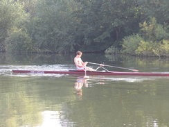
In the village I stopped off at a small newsagents for some snacks for the day before continuing on to park at the station. It was still foggy when I eventually set off, and the first mile along the Papist Way to the river flew by as my legs slowly warmed up, and once at the river I could not see the other bank due to the moisture that hung in the air. Without waiting I turned right to start heading southwestwards along the river along a path that went through a wildly overgrown area, the path seeming wilder than it had at any time during yesterday's long walk. Disembodied voices drifted across the water from early-morning rowers, the fog preventing me from seeing them through gaps in the trees as I walked along. The path passed under a large twin railway viaduct, before leaving the river via a track that led up to the A329 in Moulsford. It followed this southwards for about a kilometre, before turning down a lane that led to an attractive pub beside the river.
The towpath then rejoined the western bank of the river as it headed southwards, before long reaching Runsford Hole, near where there was the jib of a crane protruding from above some large green hoardings. The path squeezed between this and the river along some sheets of plywood, the reason for which soon became obvious the sheets ended and a waterlogged stretch of ground continued. Two men were busy assembling the planks to put down, and as water pouted down a small bank to my right it was obvious that there was a fairly major water leak somewhere. It proved impossible to get across the waterlogged area without getting my left boot soaked, and after I had crossed the area I chatted to one of the men. Apparently they are constructing a water pipeline across the river, and when I looked another set of green hoardings was visible on the other side.
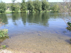
I squelched on along the towpath as it headed southwards towards Streatley, passing Cleeve Lock before heading on along an absolutely beautiful stretch of floodplain that was a joy to walk along. The fog was finally lifting, with only a few wisps of it left in the air as the path left the river to reach Streatley church and the main road. Here the route met the course of the Ridgeway that I had walked back in early June for a short distance as the road crossed a long couple of bridges across the river above Goring Lock. On the other side of the bridge the towpath descended down to the eastern bridge, before heading south along the river. As I looked back at the bridge I could see that the fairly bland concrete structure had been enlivened by large beams of wood angles across from the piers to the deck, which improved the look of the bridge massively and made it fit in much more with the adjacent Goring Lock.
The towpath initially headed southwards before curving to head southeastwards, with a house on the hillside to the right called the Grotto. The path then headed eastwards, passing under a large twin railway viaduct (the older one being by Brunel, and the older one having been constructed to a matching style) and headed on, soon leaving the riverbank and slowly climbing uphill and entering an area of woodland. The river was only about fifty yards away from and slightly below the path and was occasionally visible through the trees, and then climbed uphill and away from the river along a superb stretch of walk. At the top the path emerged from the trees and started to descend steeply down some steps into a dry valley.
By this time I was in need of a rest, so at the bottom of the dry valley I climbed over a gate into the field on the left. The sun was shining down brightly as I took my rucksack off and stretched myself out on the grass to admire the rolling hills and slope that led away from the path. It was a very pleasant place to stop, and a few people passed - including a few cyclists - along the path as I rested a few feet away. Quite how the cyclists were finding the steps into and out of the valley intrigued me, as they were quite steep and challenging. The location was so pleasant that I stayed longer than I had been planning, and it was with some regret that I picked my rucksack off and climbed over the gate before climbing up the steps out of the valley.
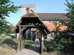
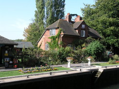
At the top of the climb a long surfaced track took me southeastwards to the B471, which it followed downhill into Whitchurch-on-Thames. In places the road was narrow, but the village itself was quite picturesque and made the stroll enjoyable. For a short period the path diverted away from the road to head past the pretty church, before curving around to pass Whitchurch Mill and some cottages. In the millpond were a bunch of canoeists, and the elegant bridge over the river was reached via a tollbooth, this being one of only two toll bridge over the Thames. Pedestrians can cross for free, and as I crossed there was a superb view across the millpond towards the mill and the church.
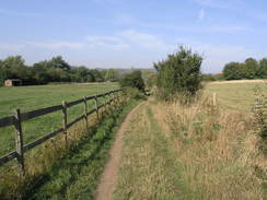
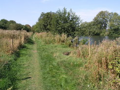
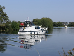
On the other side of the bridge the path passed through the car park of an adventure centre before rejoining the banks of the river. There were lots of canoeists on the river, mainly children learning how to canoe, and there were also many people strolling along another superb stretch of floodplain that led for two miles eastwards towards Mapledurham Lock, yet another beautifully-maintained lock. Here there was a little café in a hut beside the lock, and I went in to buy a 99 ice cream, which I ate as I took the track that led southwestwards into Purley-on-Thames. The next mile climbed and descended through housing estates and was by far the worst stretch of the National Trail so far, and I was glad when the path left the roads via a footbridge that headed high above the railway line near Tilehurst station.
As I walked I listened to the Grand Prix that had just started, and the path descended to run through trees between the river and the base of a large railway retaining wall for a kilometre towards a boatyard, where the river curves away from the railway. This was another pleasant stretch of riverside walking, and as the river curved to head eastwards towards Reading I could see some very posh houses on the other side of the river. In one of these on a chilly Sunday October morning in 2001 I had been to the remnants of a wedding reception, with people sleeping on the floor of a marquee and the shells of three cars that had accidentally burnt out. Sam and I had not gone to the wedding as it had been on out first anniversary, but we had decided to drop in and visit the newlyweds the day after, and it had been the strangest reception that I had ever been to.
The approach to Reading was pleasant, with a good surfaced path underfoot and some temporary fencing to the right, apparently leftovers from the Reading festival which had been held the previous weekend. Caversham Bridge was soon reached, and in the middle of the river there was a posh restaurant and bar situated on an island. I decided to cross to stop in for a drink, but once I got there I was annoyed to find a very long queue for service. As I was feeling slightly out of place in my walking gear anyway, I crossed the river to continue on, only to find a pub called The Riverside on the bank a few yards away from where I had left it!
I ordered a pint of bitter and a pint of orange and lemonade, which is proving to be which I most commonly order during a walk. I also ordered a jacket potato to eat, my first hot meal for two days, and whilst I waited for it to arrive I went to sit at one of the tables outside. A couple and their young grandchild sat down opposite me, and we chatted for a few minute as they drunk their drinks and I ate an absolutely superb potato. After they left I continued sitting as I listened to the end of the grand prix and the announcement that Michael Schumacher was retiring at the end of the season, before putting my rucksack onto my shoulders and heading off along the towpath.
It was tempting to end the walk here by diverting off to Reading station, but as there was plenty of time left I decided to walk on as far as Shiplake or Henley, which would take another couple of hours. Reading bridge was soon reached, and after this was Reading Lock. As I walked along the next kilometre of towpath large office buildings for high-tech companies, including Oracle, were visible on the right across the railway line, being rather visually intrusive on he riverside scene. Next came the footbridge that led over the mouth of the Kennett and Avon canal at its junction with the Thames. The last time I had walked along here in early 2000 the bridge had been closed, and a small boat had taken me across the canal, an unusual experience. This also led me to realise that as I crossed the bridge I had completed the very last link of my sectional Land's End to John O'Groats walk, the few yards of the bridge not actually having been walked.
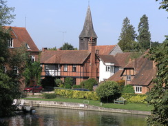
Many people were about on the riverbanks, and a few were even sunbathing, which I though of as being rather brave in September. It was a pleasant stroll along the rather busy the path as the river wound northeastwards towards Sonning Lock. Again this lock was picturesque, and the little island in the middle was particularly attractive and well-kept. A little further on I reached Sonning Bridge, and it came as a shock to me how little I remember of the path from when I had walked it six and a half years earlier. It was like I was walking it for the first time, but this was no problem as it was a superb walk. Sonning Bridge itself was a nice architecture, and once across this the towpath headed northwards along the western bank of the river.
By this time I was starting to suffer from chaffing, and this made the walk increasingly uncomfortable as I headed onwards. The views across the river were pleasant, but my increasing fatigue after the long walk yesterday was also taking its toll, and I was feeling increasingly tired and footsore. As I approached Shiplake Lock I passed a gentleman and we started chatting. He was doing his regular walk from Shiplake to Sonning, and as we talked he offered me a lift from Shiplake back to Reading. As I had not bothered to note down the times of the train from Shiplake station to Reading (which involved a change of trains) I gladly accepted the lift, and before I knew it we were at Shiplake Lock.
His car was parked a hundred yards up the road, and although this means that on the next stage of the walk I would have to walk the mile from the station to the lock to start the walk, I was relieved to be sitting down. The man was called Mr Lightfoot, and he had used to freelance for Private Eye, amongst many other jobs that he had had over the years. He was a fascinating gentleman, and before I knew it he had dropped me off outside the station. The lift took me up to the footbridge over the platforms, and after buying my ticket I had about half an hour to wait for the train back to Cholsey. The train was punctual, and when I reached my car I set off on the long journey back to Cambridge and home.
Directions
| The walk is also covered in detail in the Thames Path National Trail Guide, by David Sharp, ISBN 1-84513-062-6 published by Aurum Press Ltd. Click on the image to the right to go to the Amazon page for the book. The exceptions to this are at the start and end of the walk. At the start, leave the station and turn left to head up Station Road for a few yards until a crossroads is reached. Here turn right to head eastwards along Papist Way for half a mile to a crossroads with the A329. Cross this road and continue southeastwards along the Papist Way, which meets the river and Thames Path at about SU601855. The walk ends at Shiplake Lock, to get to Shiplake railway station turn left and head up a track and then a road for a kilometre to the station. | 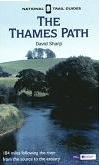 |
Distances
| From | To | Distance (m) | Ascent (ft) | Descent (ft) |
|---|---|---|---|---|
| Cholsey station | Papist Way | 1.1 | 56 | 39 |
| Papist Way | Goring | 4.3 | 128 | 131 |
| Goring | Pangbourne | 4.3 | 312 | 315 |
| Pangbourne | Reading Bridge | 7.2 | 243 | 266 |
| Reading Bridge | Shiplake Lock | 5.8 | 118 | 121 |
This makes a total distance of 22.7 miles, with 857 feet of ascent and 872 feet of descent.
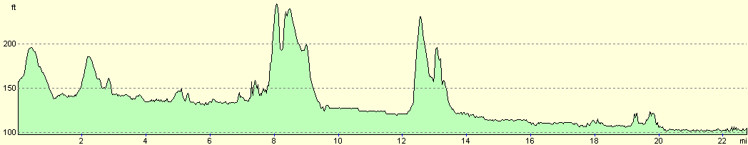
For more information on profiles, ascents and descents, see this page
Transport
There are regular train services from Shiplake station to Cholsey, changing at Twyford on the way. If you want a shorter walk, there are also stations at Goring, Pangbourne, Tilehurst, and Reading, all of which do not require a change of trains to get back to Cholsey.
Disclaimer
Please note that I take no responsibility for anything that may happen when following these directions. If you intend to follow this route, then please use the relevant maps and check the route out before you go out. As always when walking, use common sense and you should be fine.
If you find any information on any of these routes that is inaccurate, or you wish to add anything, then please email me.
All images on this site are © of the author. Any reproduction, retransmissions, or republication of all or part of any document found on this site is expressly prohibited, unless the author has explicitly granted its prior written consent to so reproduce, retransmit, or republish the material. All other rights reserved.
Although this site includes links providing convenient direct access to other Internet sites, I do not endorse, approve, certify or make warranties or representations as to the accuracy of the information on these sites.
And finally, enjoy your walking!
Nearby walks
| # | Title | Walk length (miles) |
|---|---|---|
| 61 | Reading to Marlow | 18.5 |
| 99 | Newbury to Reading | 19.6 |
| 731 | Wayland Smithy to Goring | 23.0 |
|
|

|