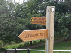
Walk #961: Cleveland Way: Kildale to Boulby Cliffs
 |
 |
|
General Data
| Date Walked | 07/09/2012 |
| County | North Yorkshire, Cleveland |
| Start Location | Kildale |
| End Location | Boulby Cliffs |
| Start time | 07.40 |
| End time | 19.18 |
| Distance | 22.9 miles |
| Description | This walk has three varied segments. A brilliantly scenic section climbs up to Captain Cook's Monument on Easby Moor, and then continues across Great Ayton Moor. A strenuous diversion then takes in the outlying peak of Roseberry Topping. The middle section of the walk takes the trail through Guisborough Forest and through Skelton to reach the seaside town of Saltburn-by-the-Sea. A final wonderful leg takes the trail east over the high cliffs, descending down into Skinningrove before reaching Boulby Cliffs, the highest cliffs on the eastern coast of England. |
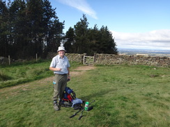
| Pack | Today I carried my Macpac Glissade rucksack containing my North Face Westwind tent, spare clothes, waterproofs, water, and enough food for two days. In total it weighed about thirty-five pounds. |
| Condition | I feel tired after this walk, but otherwise have no problems. One of my little toes has a non-painful shalow blister, but I do not known on which day of the trip that occured. |
| Weather | The day was sunny with patchy cloud; it was not overly warm, and was an ideal for walking. There was a fairly hefty breeze at times on the high coastal cliffs towards the end of hte day. |
| OS map | Landranger number 94 (Whitby & Esk Dale, Robin Hood's Bay) and Landranger number 93 (Middlesbrough, Darlington & Hartlepool) |
 |
 |
|
Map of the walk
Maps courtesy of Google Maps. Route for indicative purposes only, and may have been plotted after the walk. Please let me have comments on what you think of this new format. For a detailed table of timings for this walk, please see the table file.
 |
 |
|
Notes
I awoke early and lay in my sleeping bag listening to the radio at low volume, not wanting to disturb the other walker, Colin, who was still asleep nearby. By the time I returned from my morning ablutions he was awake and we chatted as I cooked myself breakfast. I felt a little stiff after what had been a very difficult day's walk yesterday, but I was looking forward to what promised to be a great day amongst beautiful scenery. Most of all, I was looking forward to reaching Saltburn and the coast before the end of the day.
Colin soon disappeared, but I took my time getting ready and picking up the sandwiches which the farmer had made for me. I left about twenty minutes after Colin, climbing away from the farm to join the road where I had left the trail yesterday. An easy descent down a quiet road led to a larger one. A couple of cars passed me on this road; parents taking their children to school.
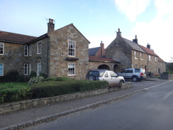
Kildale was the largest place I had seen since Osmotherley, but it was so small that I passed through it within a few minutes and was soon passing under a railway line. A steep climb then followed along a road; I was not looking forward to this after yesterday's travails, but it turned out to be easier than I expected and I did not need to stop during the ascent. It helped that the climb was along a road which is always easier.
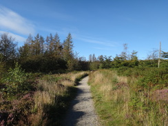
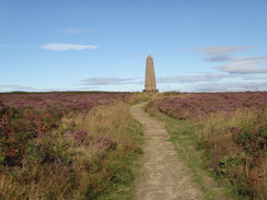
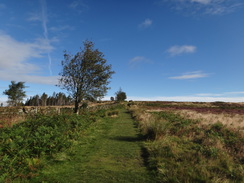
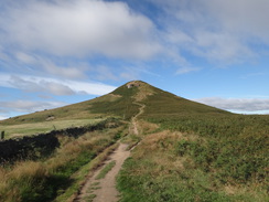
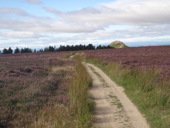
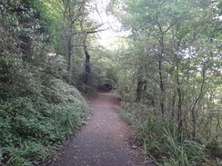
A path then headed through woodland, slowly and easily climbing as it did so. A short but steep section led to Captain Cook's Monument at the top of Easby Moor, a memorial to one of Yorkshire's most famous sons. The views from the monument were suitably grand; I could see almost all the hills that I traversed yesterday, their peaks standing proud in the sunshine.
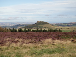
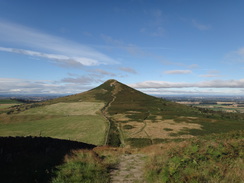
The descent was easy along a good path that obviously provides the main route up to the monument, and I soon reached the road at the bottom. Another climb followed, although this was short and hardly onerous. Soon I was striding along a good path across moorland, my next target of Roseberry Topping occasionally visible through the trees on my left. Soon I reached the point where the trail makes another diversion to the hill. Colin was standing at the junction eating a sandwich; we said a quick hello before he disappeared off towards the sea.
Since I did not want to carry my pack to the summit only to return the same way, I dropped it into a deep patch of heather where I hoped it would remain unmolested. As usual when I take my pack off I felt as light as a feather, and I nearly jogged down the hillside to the plain of Roseberry Common, a flat area of ground that lies between the main bulk of the moor and the separate summit of Roseberry Topping. The next ascent was steep, and on the way I met an elderly man who was slowly but steadily climbing the slope. He was collecting for an air ambulance, and was walking the trail in eight days. We exchanged pleasantries and I sped on up the hill.
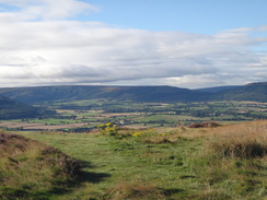
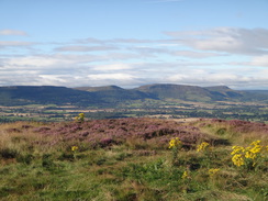
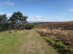
About ten people were enjoying the spectacular views from the summit. A couple had binoculars and were staring to the north over Middlesborough. If the summit is this busy on a Friday morning, I can only imagine how crowded it gets on a weekend afternoon. I was more concerned with the view to the east, where the sea shimmered in clear view. The line of hills I had crossed yesterday lay in the opposite direction, and the terrain between me and the sea seemed much flatter and easier.
I was slightly concerned about the security of my pack and did not linger on the summit. It took me twenty minutes to descend from Roseberry Topping and ascend back onto the moor, where I was glad to see that my pack was safely where I had left it. I pulled it onto an area of shorter grass and munched on my sandwiches whilst the sun dried my sweaty socks. It was a glorious day, and I knew that the worst of my journey to the sea was over.
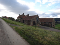
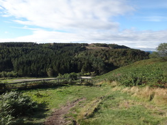
The elderly walker approached as I was getting ready to go, and we chatted for a while. He had taken up walking after an angina attack, and had already completed Hadrian's Wall twice and the Pennine Way once. Sadly I could not talk for long, and soon I was striding off across the moorland. A gentle descent down to a boggy area of ground was followed by a climb past a farmhouse to reach Guisborough Woods.
Shortly after entering the woods I made a mistake; I asked advice from a passer-by about the correct route and followed his advice against my better judgement. I headed down a track only to realise that the correct route lay at the top of Highcliff Nab. Rather than turn back I continued along tracks that regained the height unnecessarily lost before I rejoined the trail about half a mile further on.
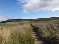
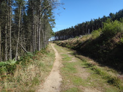
The route through the woodland was not particularly enjoyable, although gaps in the trees granted me some grand views over Guisborough and beyond. The paths and tracks rose and fell annoyingly and there were many junctions to negotiate, although fortunately these were well waymarked. I passed a group of Duke of Edinburgh award scheme students toiling their way uphill before starting a long descent past a motorcycle scrambling track to reach the main road in Slapewath.
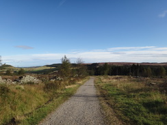
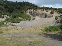
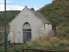
I was ahead of schedule, so I decided to nip into the pub in the village, which was situated just off the main road. I half-expected the elderly gent to enter as I supped my pint, but there was no sign of him by the time I left. A long climb led uphill past an old quarry, after which another ascent led to a long track called Airy Hill Lane. The sea was visible at times as the track slowly fell. The trail passed another couple of pubs in Skelton Green before starting a steep descent into Skelton.
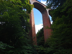
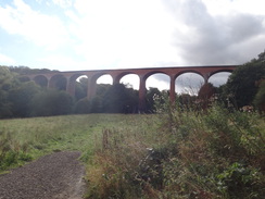
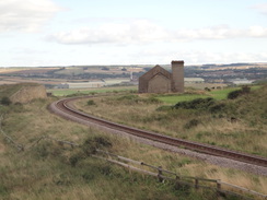
Given the grandeur of the scenery earlier in the day, the approach to Saltburn was rather a let-down. The trail crossed a new road and headed through a housing estate before descending through woodland to cross the Skelton Burn. One highlight of the day was a magnificent brick viaduct that seemed to fly over the valley, its arches so tall that it was hard to see the top. The railway line across the viaduct is still in use by mineral trains to the Boulby Mine, although it nce went as far as Whitby.
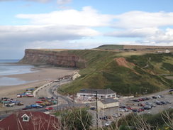
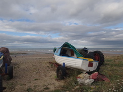
The trail annoyingly rose and fell along the valley before eventually climbing up to join a road in Saltburn. I had never seen this side of the town before and I was impressed by the quality of the architecture - it certainly did not appear to have suffered the same fate as so many seaside resorts. A long, zigzagging road took me down to the seafront, where I joined the route I had followed on my coastal walk.
Here I was faced with a decision. It had been my intention to stop at Saltburn for the night, but there was no campsite and I really did not feel like paying for a bed and breakfast. There was enough daylight for me to walk a few more miles, and I was feeling fit. I stopped on a seafront bench to buy an ice cream and then made my way across the outfall of the Skelton Burn towards a pub. Sadly this was not serving food until six, far longer than I wanted to wait, so I had a quick pint of shandy whilst the barmaid kindly filled up my water bottles.
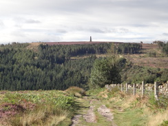
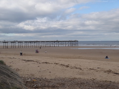
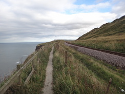
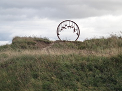
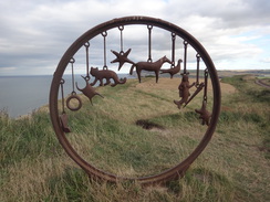
Despite being heavily loaded with water, the ascent up the cliffs to the south of Saltburn proved easy, and the views back towards the pier and onto Merske and Redcar rewarded the effort. Once at the top the going was easy; the cliffs rose slowly enough that it hardly felt like a climb, and the good views out to sea occupied my mind. Soon a railway line came in from the right, and the path squeezed between it and the cliff edge. Nearby there was a strange monument I remembered from my previous walk, a circular steel sculpture with a series of objects hanging down from it.
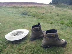
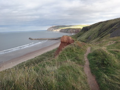
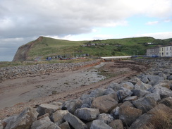
A nearby spot seemed ideal for camping, but I was still feeling fit and there was still plenty of daylight left. The railway line curved away inland as the cliffs began to fall, and eventually a series of steps led down onto the beach. I trudged through the sand before climbing up to pass between the abutments of an old railway bridge on Skinningrove jetty. The village of Skinningrove itself is not the prettiest on this stretch of coast, the steel works having dominated the area for a number of years. But the people were friendly as I sat down once more to empty sand out of my boots and contemplate my next move.
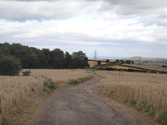
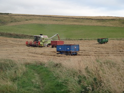
I was tempted to put my tent up above the tideline on the beach, but instead I decided to continue on. A steep but mercifully short ascent took me back up onto the cliffs, and the next mile was pleasant and relatively level walking. A combine harvester was just completing a field of barley as the trail turned to head inland, joining a track that passed a farm. A path then climbed steeply through gorse, and soon I was at the top of the cliffs.
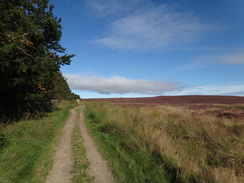
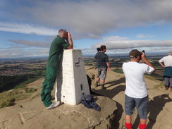
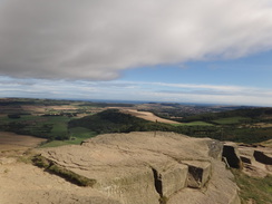
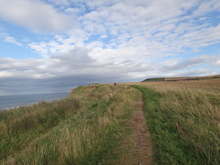
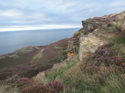
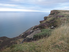
Several reasonable camping spots came into view; each was relatively secluded whilst offering a flat area of shortish grass and grand views. But by this point I had settled my mind on one target: the highest cliffs on the east coast of England at Rock Cliff lay only a mile away, and it seemed like a promising place to wild camp. I pressed on; the gradient was not too steep but the path was narrow in places, with a fence protecting fields to the right. Good views kept me going, and soon a trig pillar marking the highest point on the cliffs came into view in a field to my right.
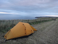
There was no really suitable place to camp on the path, but the field that housed the trig pillar had been harvested. I nipped over a stile and quickly erected my tent in the corner of the field next to the fence. The hefty breeze on the 210-metre cliffs were keeping the insects away, and I lay outside my tent as I watched the sun go down. It was not a bad place to spend the night; the brow of the hill kept me out of sight of the nearby farm, and I was not damaging any crops. Once it got dark I settled into my sleeping bad and fell quickly asleep.
 |
 |
|
Directions
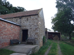
This walk starts at Park Farm at NZ602084, about a mile to the southwest of Kildale. Walk past the farmhouse and then turn right through a gateway to enter a field to the east of the farm. Once through the gate, angle right to join a fence that heads uphill on the right. After a quarter of a mile a stile is reached beside a field gate; cross this to join the Cleveland Way on a road at NZ605085. Turn left and go through a clapper gate beside a cattle grid and continue along the road.
Follow the road as it heads north. After a sixth of a mile it curves to the left to head north-northwestwards for another quarter of a mile until it ends at a T-junction with another road. Turn right along this road and follow it as it enters the hamlet of Kildale. Take the first road off to the left, Station Road, and after passing some cottages on the right, turn right down another road. This descends downhill, curving to the left to pass under a railway bridge at NZ606096, and then cross a bridge over a stream.
Follow the road to a cattle grid, after which it starts climbing uphill in a rough northerly direction. it passes Bankside Farm on the right and some barns on the left to reach a clapper gate beside a cattle grid. The ascent starts to slacken three-quarters of a mile after the railway bridge. On a right-hand bend at the crest of the hill, turn left to join a gravel track that goes through a gate to enter woodland.
Follow the track westwards; when the track curves to the right after a fifth of a mile, turn left to follow a footpath through the trees. The path passes a stile and continues on as the tip of Captain Cook's Monument becomes visible ahead. After leaving the trees the path climbs steeply up stone steps. Go through a gap in a stone wall and continue uphill across moorland to reach the monument at NZ590101.
At the monument turn right to follow a flagstone path northwards. It descends across the moors and becomes a gravel path that heads downhill through trees. After half a mile it goes through a pedestrian gate beside a field gate to reach Dikes Lane at NZ591110. Turn right for a few yards to pass a car park on the right, and then turn left. Ignore a larger track angling off to the right, and instead take a footpath that heads up steps to the north. When the steps end a more gradual ascent continues, following a fence and then a wall on the left. Continue along this path until a pedestrian gate is reached at NZ587127, 0.9 miles after the road.
Here the trail makes another official diversion to visit the outlying summit of Roseberry Topping which lies half a mile to the west. Go through the pedestrian gate and turn left down some steps. Eventually the gradient slackens; continue on with a wall on the left to reach the base of Roseberry Topping. More steps and a steep zigzagging path lead up to reach the craggy summit at NZ579125. Once there, descend off the hill by the same route and climb the steps back up to reach the pedestrian gate and the main Cleveland Way route.
Three paths radiate out from the gate across the moorland; take the middle path that heads eastwards; do not take the path that runs along the wall on the left or the one beside the trees on the right. This path climbs a slight summit before falling to reach a bridleway gate. Go through this gate to join a track and then turn right along this track. It immediately curves to the left and continues falling with forestry on the left. Go through a vehicle barrier and then turn right along another track to reach a bridleway gate beside a field gate.
Go through this, pass another vehicle barrier and continue uphill. After a couple of hundred yards turn left to join a narrow footpath that heads across the moorland. The path curves to the left and the right as it descends, joining a fence on the left. It crosses a rough, reedy area with flagstones across boggy sections before starting to climb alongside a wall, passing Highcliffe Farm on the left. Go through a bridleway gate through a fence near the farm and continue climbing. The wall and path both curve to the left, aiming for trees ahead. Ignore a gate off to the left, and shortly afterwards turn left through a clapper gate to enter the woodland at NZ611135.
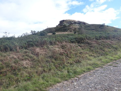
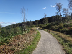
Follow the path as it skirts just inside the western edge of the woodland. The path curves to the right away from the wall for a short distance to meet a track. Turn left along the track for a few yards, and then right along another path that climbs up to reach the summit of Highcliff Nab. Follow the path as it curves to the right at the top and climbs slightly for a couple of hundred yards to join a track. Turn left to follow this track eastwards as it slowly falls. Ignore a track leading off to the right, and instead follow the main track as it curves down to the left to join another track at NZ619141.
Continue northeastwards along this track; when it curves to the right, turn left to continue straight on along a path through the forest. This path climbs uphill and then curves to the right; do not continue straight on downhill. It then curves to the left, still climbing to join another track. Continue along this track; as it soon curves to the right continue straight on along another path that curves to the right. As the path forks, take the lesser left-hand branch.
When it forks again, take the lesser right-hand branch that climbs uphill to join a bigger path. Turn left down this and follow it as it descends. When it meets another track, turn left and follow it alongside a fence on the right and trees on the left. After a while the path curves to the right up a few steps to reach a pedestrian gate. Go through this and follow it as it immediately curves to the left. The path descends to cross a stream and climbs up the other side. Follow a fence on the right to reach a clapper gate that leads out onto a track at NZ639154.
Turn left to follow this track as it plunges steeply downhill. Just before a tarmac track is joined at the bottom, turn right through a clapper gate to enter woodland. The path runs between fences; when the fence on the left ends, continue following the fence on the right as it curves to the right. The path climbs uphill; go through a squeeze-stile as the path continues climbing. Go through a second field stile, following a fence on the left to reach a track. Turn right up this track for about five yards and then left through a third squeeze stile, after which the path continues between fences.
Go through a fourth squeeze stile and follow the path as it curves half-left across an area of tracks to reach a fifth squeeze stile. On the other side the path continues between fences. A sixth and seventh squeeze stile guard a track coming down the hillside, and the path continues beyond these without fences. When another path is reached, turn left downhill to reach a clapper gate beside a field gate and then turn left along a track that parallels the A171 main road. It passes a little picnic area on the right and then joins the A171 at NZ642157.
Carefully cross the A171 to reach the pavement on the northern side of the road, and start following the road westwards, passing the Fox and Hounds pub away to the right (this is the first pub on the trail since Osmotherley, about 30 miles away). Take the first road to the right and then immediately turn left along an access road. When the road soon ends next to a house, go through a squeeze stile to join a path with a fence on the right; this leads to a second squeeze stile. Immediately afterwards the path curves to the right to join another path, passing a disused quarry on the left.
The path climbs steps uphill and curves to the left to reach a third squeeze stile. The path continues up more steps that take it above the quarry to reach a fourth squeeze stile. More steps lead to a fifth squeeze stile and some benches. Here the path curves to the right to follow a fence on the right; the gradient slackens as the path heads north with woodland to the left. The path goes through another squeeze stile and turns right to head uphill with a hedge on the right. It goes through a gap in a stone wall and continues on with a wall on the right to join the end of a track in the corner of a field at NZ642164.
Turn left and follow this track as it heads northeast, passing Airy Hill Farm on the right. The track slowly becomes better quality as it heads on, passing under some power lines and then houses on the left. The track ends at a road junction in Skelton Green after 1.4 miles at NZ656181. Turn right to follow a road north through the village; it passes the Green Inn on the right before ending at a T-junction with Boosbeck Road at NZ656183.
Cross the road and go through a clapper gate to join a surfaced path that runs between fences. The path crosses another path and continues on to another clapper gate. The path squeezes past the end of a hedge and runs downhill between hedges before curving to the right and descending to reach Swilly Lane in Skelton. Turn right down Swilly Lane for a few yards before taking a path that leads off to the left, heading steeply down steps. The path joins a road on the left and follows this for a few yards to reach the High Street at NZ658188.
Carefully cross the road, and on the other side head down Coniston Road. Pass the library on the right and then turn right down Derwent Road. This soon curves to the left and continues downhill. When it ends at a T-junction with Windermere Drive, cross the road and continue on, still following Derwent Road. This curves to the left and then the right; when it ends squeeze through a gap in a hedge to enter some scrubland. The path curves to the left to head north across the scrubland; it passes through a gap in a hedge to enter another field. Cross this to reach Bowland Road.
Cross Bowland Road and head straight on along a gravel path between houses. The path curves to the right to enter woods, following a fence on the right. It passes under a large road bridge carrying the A174 road overhead. On the other side the path opens out into a field on the left; at the end of the field it curves to the left and then the right past a fence to enter woodland. The path heads downhill, initially along a slope and then steps. It curves to the right and follows a river on the left to reach a footbridge over the river at NZ660201, with a railway viaduct high overhead.
Cross the footbridge and follow the path on the other side as it heads under the arches of the viaduct. The path then curves to the left up a track, and then right to enter Saltburn Valley Gardens. When the track forks, take the right-hand branch which heads downhill. When this meets a surfaced road continue straight on up a slight slope. At a little picnic area, turn left up a surfaced path. When this curves to the right, turn left up steps to reach Albion Terrace in Saltburn. Turn right to follow this road north; it soon swings to the right and becomes Glenside. Continue along this road until it ends at a T-junction; here turn right to head straight on. When the road forks, take the right-hand branch that heads down a zigzag to reach the sea at NZ667216. Care needs taking on the zigzag as the pavements are narrow.
At the bottom, turn right to follow the road southeastwards. It immediately crosses the Skelton Beck on a bridge and then curves to the left to head towards The Ship pub. The road curves to the right just before the pub; follow it for a few yards past the pub car park and then turn left up a path. When this forks after a few yards, head up a series of steps on the left that head uphill to reach the top of the cliffs. The steps end and a path slopes uphill along the edge of the cliffs. Go through a gap in a fence and continue along the edge of the cliffs.
1.3 miles after The Ship, the path goes through a fence at NZ688218 and becomes increasingly squeezed by the cliff edge on the left and a railway line on the right. The latter eventually curves away and the path continues on along the cliff edge. It passes a large metal sculpture and heads on; after a while it curves to the right away from the sea, then left through a hedge, and left once more to rejoin the cliff edge.
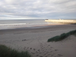
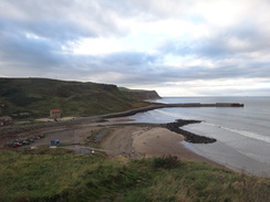
At NZ707204 the path turns to the left and heads down a series of steps that lead down towards the beach. Join the beach and turn right to start following it eastwards as it approaches Skinningrove Jetty. Climb up onto the jetty using a ramp, and then pass between the abutments of an old bridge and then turn right to follow a track alongside the shore. This passes a car park on the right and then joins a road called Marine Terrace. Turn left along this, passing houses on the right, and when the road ends squeeze past the end of the houses to reach another road. Turn left to reach a bridge over the river in Skinningrove at NZ714200.
Cross the bridge and follow the road as it curves to the right. On the bend, turn left up some steps that lead up the hillside to the east, soon joining the clifftop. The path squeezes between the cliffs on the left and a fence on the right. A mile after Skinningrove at NZ729197, the path turns right to head inland. The path climbs as it follows a hedge on the left and ends at a junction with a track. Turn left to follow this track as it heads eastwards; it goes through a clapper gate beside a farm gate and after 150 yards enters a farmyard.
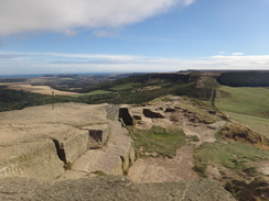
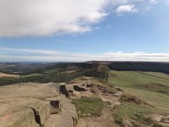
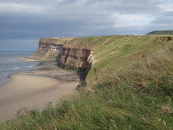
When the track ends in the farmyard, head diagonally across some grass to reach a stile. Cross the stile and head up a path to reach a second stile. The path climbs through bracken; a couple of stretches of boardwalk are crossed before the path follows a stone wall on the right. The wall becomes a fence; follow the cliffs as the path generally climbs, although there are some minor descents. Go through a clapper gate and continue on. This particular walk ended on the highest cliffs in England at NZ750195.
 |
 |
|
Distances
| From | To | Distance (m) | Ascent (ft) | Descent (ft) |
|---|---|---|---|---|
| Park Farm, Kildale | Captain Cook's Monument | 3.0 | 764 | 243 |
| Captain Cook's Monument | Roseberry Topping | 2.6 | 587 | 699 |
| Roseberry Topping | Slapewath | 6.1 | 928 | 1480 |
| Slapewath | Saltburn seafront | 4.9 | 627 | 1007 |
| Saltburn seafront | Skinningrove | 3.8 | 735 | 732 |
| Skinningrove | Rock Cliff, Boulby | 2.5 | 778 | 131 |
This makes a total distance of 22.9 miles, with 4419 feet of ascent and 4292 feet of descent.
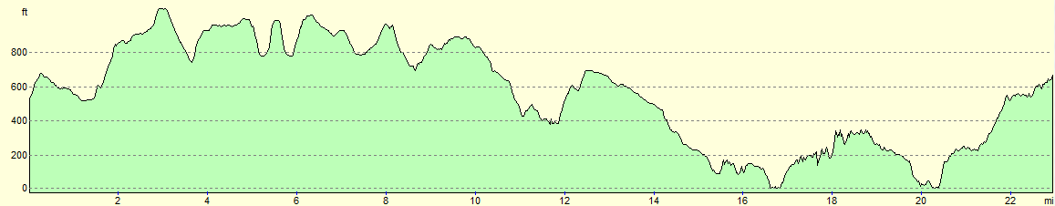
For more information on profiles, ascents and descents, see this page
Accommodation
I spent the night camping beside the trail at Bulby Cliffs, the highest cliffs in England. Although there was no pottable water, it was a perfectly pleasant wild-camp.
 |
 |
|
 |
 |
|
 |
 |
|
 |
 |
|
 |
 |
|
 |
 |
|
 |
 |
|
 |
 |
|
 |
 |
|
 |
 |
|
 |
 |
|
 |
 |
|
 |
 |
|
 |
 |
|
 |
 |
|
 |
 |
|
 |
 |
|
 |
 |
|
 |
 |
|
 |
 |
|
 |
 |
|
 |
 |
|
 |
 |
|
 |
Disclaimer
Please note that I take no responsibility for anything that may happen when following these directions. If you intend to follow this route, then please use the relevant maps and check the route out before you go out. As always when walking, use common sense and you should be fine.
If you find any information on any of these routes that is inaccurate, or you wish to add anything, then please email me.
All images on this site are © of the author. Any reproduction, retransmissions, or republication of all or part of any document found on this site is expressly prohibited, unless the author has explicitly granted its prior written consent to so reproduce, retransmit, or republish the material. All other rights reserved.
Although this site includes links providing convenient direct access to other Internet sites, I do not endorse, approve, certify or make warranties or representations as to the accuracy of the information on these sites.
And finally, enjoy your walking!
Nearby walks
| # | Title | Walk length (miles) |
|---|---|---|
| 235 | Billingham to Redcar | 12.3 |
| 236 | Redcar to Runswick Bay | 17.2 |
| 237 | Runswick Bay to Robin Hoods Bay | 14.9 |
|
|

|