Walk #962: Cleveland Way: Boulby Cliffs to Robin Hood's Bay
 |
 |
|
General Data
| Date Walked | 08/09/2012 |
| County | North Yorkshire |
| Start Location | Boulby Cliffs |
| End Location | Robin Hood's Bay |
| Start time | 06.47 |
| End time | 17.37 |
| Distance | 21.2 miles |
| Description | This walk follows the Cleveland Way as it follows the coast southeastwards, passing through Staithes, Runswick Bay, Sandsend and Whitby before reaching the picturesque village of Robin Hood's Bay. |
| Pack | Today I carried my Macpac Glissade rucksack containing my North Face Westwind tent, spare clothes, waterproofs, water, and enough food for one day. In total it weighed about thirty-five pounds. |
| Condition | I am very tired after this walk, but otherwise feel fine. |
| Weather | The day was a mixture of sunhsine and cloud, with long periods of sunshine. There was a breeze on the high cliffs, but not enough to alleviate the temperature, which rose very high later on in the afternoon. |
| OS map | Landranger number 94 (Whitby & Esk Dale, Robin Hood's Bay) |
 |
 |
|
Map of the walk
Maps courtesy of Google Maps. Route for indicative purposes only, and may have been plotted after the walk. Please let me have comments on what you think of this new format. For a detailed table of timings for this walk, please see the table file.
 |
 |
|
Notes
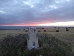
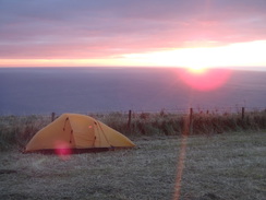
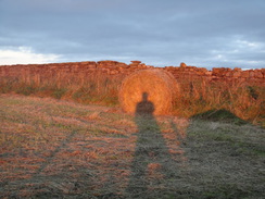
I awoke before dawn and emerged to take some photos of the sun rising from the trig pillar at the top of the field. The low sun cast ethereal shadows across the stubble as I slowly pulled down my tent and packed my rucksack. I had had a reasonable night's sleep despite the wind, and was looking forward to an easy walk into Whitby. Best of all, my exertions of the previous evening meant that the first couple of miles of the day into Staithes were all going to be downhill.
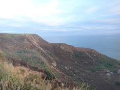
As had been the case for the entire trip so far, the morning was sunny and promised to be very warm by mid-afternoon. It seemed wise to get as much distance under my belt as possible during the morning and so I headed off along the trail. Initially the path was very much as it had been the previous evening; it ran along a narrow gap between the cliff edge and the fence protecting the fields. However it soon changed; the path headed straight downhill as the cliffs dramatically lowered in height past some quarries, and before I knew it I was following a road in Boulby.
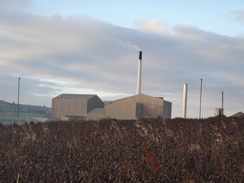
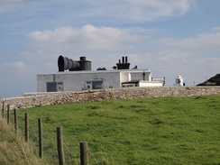
Off to the right was Boulby Mine, which at 1,400 metres in depth is Europe's second-deepest mine. The mine produces two main products - potash for use as a fertiliser, and rock-salt. It is also home to a scientific experiment in the form of a large dark-matter detector. The buildings were clearly visible, and a steam of steam was steadily streaming from a smokestack. It employs 850 people and is a major employer in this remote area; the railway line from Saltburn that I passed yesterday was kept open to take some of the 1 million tonnes of material mined to market.
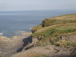
A path led between fields before joining another road that I would follow all the way into Staithes. Soon a track led off to the right and the reason became obvious: a small section of the road had fallen over the edge of the cliff. A little further on a berm blocked most of the width of the road, obviously to prevent traffic from approaching the dangerous section. It was the first real indication of erosion I had seen on this stretch of coast, which seems remarkably stable.
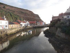
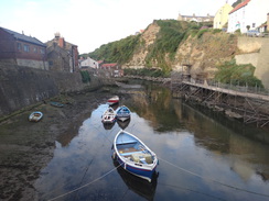
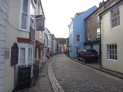
The road that looped down into the village had a long string of water pipes running down the side, and a sign stated that it would be closed in a few days time for works. Soon I was crossing the bridge over Staithes Beck and staring over the water, with the little boats called 'cobbles' stranded on mud by the ebbing tide. Staithes is rightfully famed for its beauty, and it is truly an unspoilt gem. I paused on the bridge for a while and chatted to a visitor before heading along the road through the village. The pub was not open at this early hour, and a solitary car could be heard rumbling along the cobbles (stones, not boats) long before it came into view.
A steep ascent led out of the village and onto the cliffs to the south, and a little hut by a farm at the top contained a number of drinks for sale. Sadly it did not have the Ribena that I really craved, and so I reluctantly closed the door and strolled on. My water supply was fine, and I figured that it would see me through to Sandsend. There were more good views from the path out to sea, and before I knew it I reached Port Mulgrave.
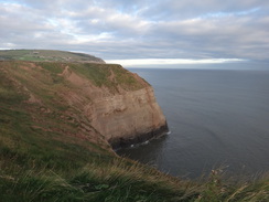
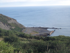
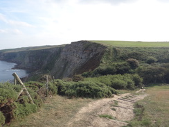
This is a rather strange name for the village as no port can be seen below. The ironstone mines that led to the village's development were inland, and a long tunnel led down to a harbour at the base of the cliffs. The industry closed and erosion damaged the harbour; the remainder was mostly destroyed during the Second World War to prevent its use by any German invasion force. Although it does not seem a very good place for an invasion: there is hardly any beach and the cliffs above are 90 metres high.
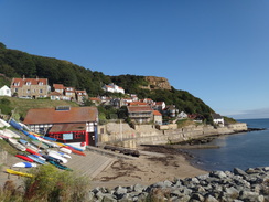
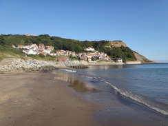
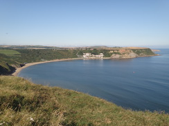
My mobile finally got a signal as I followed the cliffs towards Runswick Bay and so I chatted to Sencan, who was getting ready to go out to a party. The going was easy, and soon the path turned inland away from the cliffs to reach a road above Runswick Bay. The trail followed a road steeply downhill; there were steps on the right, but I found the road to be less jarring on my legs. Soon I reached a road junction just above the beach and I shrugged my pack off onto a bench.
A nearby cafe was not due to open for another half-hour, but I nipped in and asked if the lady could fill up my water bladder. She kindly did so, and I went back to the bench and took my boots off to allow my feet to cool down. A couple in full walking kit stopped nearby and it turned out they were also doing the trail, but as they were concerned about the tide on the next stretch they wanted to press on. I watched as they strode along the beach before they disappeared inland at Hob Holes.
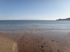
Once my feet were cooled off I shouldered my rucksack and headed down onto the beach. A fair few people were about despite the early hour, and I can only imagine that it would get much busier in the afternoon as people made the most of the autumnal sunshine. It felt good to be walking on sand rather than cliffs for a change, and the tide was out far enough for me to get past a little headland to reach Hob Holes. 'Hob' is a local term for a household spirit, and the holes are caves that lead into the cliffs were presumably said to be their homes.
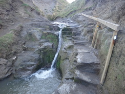
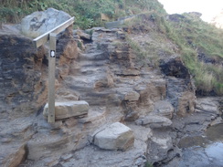
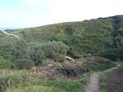
Nearby a steep-sided valley carries a stream towards the beach and sea. This is perhaps my favourite spot on the entire trail; the stream trickles down the cliff and the path follows it inland before climbing some steps cut from the living rock. It is a wonderful spot and I wonder how many of the holidaymakers who visit the beach ever make their way to see it.
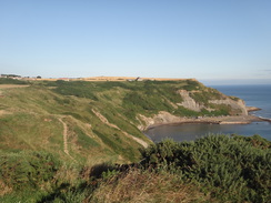
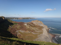
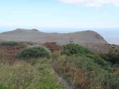
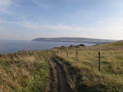
Many pleasures have downsides, and Hob Holes immediately demanded compensation in the form of a steep climb up the cliffs. The climb never seemed to end, but eventually I found myself at the top and staring over the sea once more. Fortunately the going was easier as the path headed east towards Kettleness. This was once a village, but most of the houses were lost in a cliff slump one night. The nearby headland has also disappeared, although that is due to quarrying.
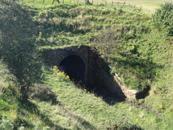
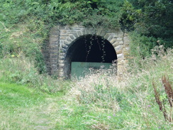
The trail passed Kettleness Farm and then continued along the cliffs as it curved to take a southerly course. Soon a tunnel portal could be seen below, part of the old line between Saltburn and Whitby. It was becoming warmer as I walked along the cliffs, and it was a relief when the path dropped steeply down to reach the old railway trackbed near another tunnel portal. The going for the next mile was easy as the trail followed the trackbed as it wound around the coast, passing several quarries on the way. It was a wonderfully easy stroll, and soon I reached the main road in the little village of Sandsend. The old platform on the railway line at Sandsend was visible through the vegetation, and large cracks showed that the land was slowly slipping towards the sea.
I was tempted to stop at a little beachside cafe, but there was nowhere shaded for me to sit. Instead I walked on to reach a pub on the other side of the East Row Beck. The pub was busy, but it was still early enough for me to get a table. I rested my rucksack against a chair and went to the bar to order some food and a couple of pints of shandy. Before the food came a couple came down with their two young children; since I was sitting alone on a four-seat table I moved over to the smaller adjacent table and waited for my food.
We chatted amiably, and their son even tried to lift my pack, which was nearly as tall as him. The couple had walked the Cleveland way before, and we talked about some of the places I had just visited. Some photos on the wall showed the railway line spanning the beck on a large girder bridge, long since removed.
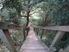
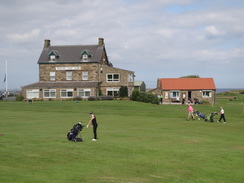
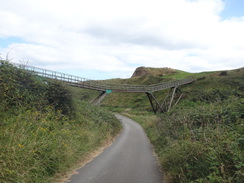
My original plans had been to get as far as Whitby, which was now less than three miles away. As I was feeling fit it seemed sensible to walk further and to find somewhere to camp on the way. I said goodbye to the family and set off down the road. It was even hotter than before, and I was soon sweating as the trail followed the main road uphill past a golf course. Eventually a path diverted off the road and passed under an elegant wooden bridge before meeting the coast. An easy path then followed the cliffs east into Whitby.
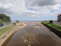
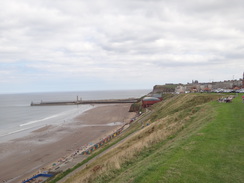
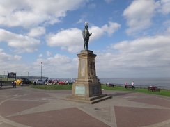
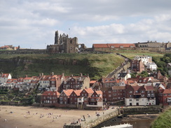
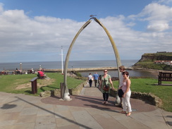
Soon I reached one of Whitby's most photographed features, the Whalebone Arch. This is two massive whale bones arranged into an arch. People were waiting to be photographed under it, and it was all a vast difference to my October visit ten years before, when the area had been very quiet. Nearby was a statue of Captain Cook, Whitby's most famous son. I stared over the water for a few minutes before starting the descent into the centre of the town. Instead of following the official route, which I had walked before, I decided to take another route down the narrow streets to reach the bridge over the River Esk.
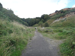
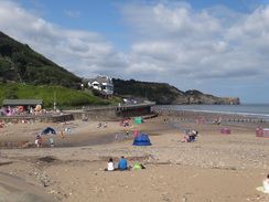
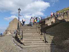
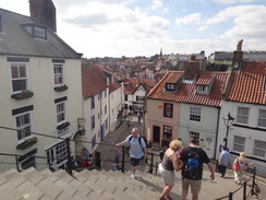
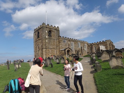
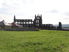
The centre of the town was absolutely bustling, with most of the shops and streets filled with people. Indeed it was so crowded that progress was slightly difficult and the pubs were overflowing. I did not want to try and push my way in, but realised that I needed some water. Soon I reached the base of the 199 steps that lead up the cliffs to the famous ruins of Whitby Abbey. Every fifty steps I stopped to admire the view (otherwise known as taking a breather), but the climb was hardly difficult and soon I was pushing past the crowds outside a church to reach the ruins.
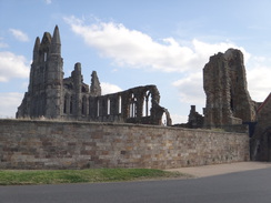
I was hoping that there was a cafe at the ruins that would allow me to fill my water bottle, but in the car park was the next best thing: an ice cream van with chilled bottles of water. I bought an ice cream and three bottles and went to sit at the edge of the car park, using a coach's shadow to keep the sun off me. I filled up my bladder from the smaller bottles as my bootless feet cooled off. People were walking around the abbey's dark and brooding ruins; try as I might, I could see no sign of Dracula amongst them.
I was still feeling rather fit, so I decided to make Robin Hood's Bay my target. I had my accommodation list in the top of my pack, and it turned out that the campsite on the hill above the village was full. However the owner told me that as I was a walker and had a small tent, they could find me a pitch for the night. Thanking her profusely, I lifted my pack and set off.
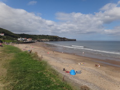
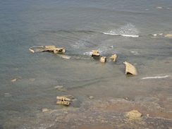
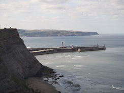
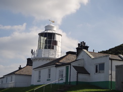
The path followed the coast eastwards, passing through a caravan park and above what appeared to be a ship's broken hull. I could clearly see the stern and what looked like part of one side, whilst what may have been the bow was under water. It was incredibly hot for the time of year and I was soon perspiring as the footpath rose and fell. On the map the path looks level, but the going on the ground proved much harder than I expected, possibly due to the heat. The path squeezed past a large fog signal to reach Whitby lighthouse. This was a squat affair and not the tall cylinder that usually springs to mind, the lighthouse relying on its position high on the cliffs to provide a far-reaching signal.
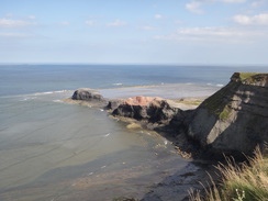
By now I was utterly knackered and had run out of energy. A series of steep-sided valleys punctured the route; none of these were deep, but all proved hateful in the heat. The views out to sea did not compensate me for the effort, and I started to think that I had made the wrong decision in not stopping in Whitby. The only upside was that there was plenty of daylight left, but I did not want to stop. A fantasy developed in my mind of going to the campsite and washing some clothes, using the sunshine to dry them. This kept me going on even when a short break would have been wise.
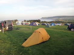
The Scarborough to Whitby railway line - now a cycle path - came into view on the right, and eventually and deliciously the path reached the main road in Robin Hood's Bay. That was not the end of the day's walking, as the campsite was about a quarter of a mile up the hill. I toiled along the road until Hook's House Farm eventually came into sight. A man checked me in and found me a patch of grass. There was a slight slope, but nothing that would prove problematic. I thanked the man, dropped my rucksack to the ground and collapsed.
I had been lying down for a few minutes when a man from a nearby VW Campervan came over and asked me if I wanted a cup of tea. Not wanting to look a gift horse in the mouth I said yes, and a few minutes later a steaming hot cup of tea was placed on the grass beside me. Another man then came out of a caravan and offered me a quarter of apple pie; both offers were extremely kind and gratefully received.
After another ten minutes I slowly put up my tent and went for a wash to try to make myself look more civilised. I changed into some clean clothes, put all my electronics into a clothes sack and headed off to the nearest pub. Sadly this was near where I joined the main road, so I had to head all the way back down the hill. The meal was filling, and the sky was darkening as I made my way back up the hill feeling remarkably refreshed.
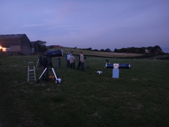
It was nearly dark by the time I got back to the campsite, and I went over to a Star Party that was taking place in a field beside the campsite. Several telescopes were set up on the grass and a man was giving a talk about deep-space objects. The telescope automatically focussed on various galaxies and we took it in turn to look through the viewfinder. It was absolutely fascinating and I had to tear myself away at ten thirty to go to bed, far later than I really wanted. It had been a superb evening, with kindness, alcohol, food and a great stellar display. Camping rarely gets better.
 |
 |
|
Directions
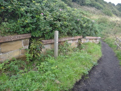
This walk starts off on the Cleveland Way on Boulby Cliffs at NZ750195. Initially follow the cliff edge southeastwards as it slowly falls past a series of fields on the right. After nearly half a mile it curves sharply to the left to start descending down a steep slope. After a short distance it curves to the right to continue along the (now lower) cliff edge. Go through a clapper gate at NZ759191 and continue on to reach the end of a road in Boulby beside a house on the right.
Follow this road as it heads downhill; it passes Boulby Lodge on the right and then immediately curves to the right; as it does so continue straight on along a grassy path, sometimes between fences. This path continues across a field to rejoin the cliff edge. Here turn right and then left to join a surfaced road that was once called Cowbar Lane. Follow the lane as it skirts the cliff edge eastwards for half a mile; at one point a diversionary unsurfaced track has been created on the right to avoid a cliff fall on the original road. A totally new road has been built further inland to avoid this road, which is now closed to traffic.
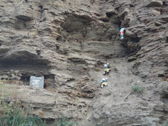
After half a mile the track ends at a T-junction with the new road. Turn left along another road that skirts the cliffs on the left. This road passed houses on the right and then curves sharply to the right as it plunges downhill past Cowbar Nab. Keep an eye-out for a gnomish mountain rescue team on a rockface on the left as the road descends a hairpin to the reach the bottom of the valley. At the bottom, immediately turn right to cross a footbridge over Staithes Beck at NZ781188.
Cross the footbridge over the beck and then follow a narrow house-lined road for a few yards until it ends at a T-junction with the High Street. Head straight on down the cobbled High Street; it soon curves to the left to reach a slipway. At the top of the slipway turn right to head past a pub on the left. Shortly afterwards turn right to head up Church Street; do not continue along High Street into a car park. Church Street climbs steeply uphill; when the road ends continue straight on along a stepped path. The path forks when the steps end; take the left-hand branch that slopes uphill towards a farm.
Pass a barn on the right and follow a path between fences. The fence on the right ends and the trail continues along a track for about a hundred yards to a field gate. The path skirts to the right of the gate and follows a fence on the left. At the end of the field, go through a pedestrian gate and turn slightly to the right to continue steeply uphill to reach a pedestrian gate in the top corner of the field. The cliffs are met on the other side; continue on with the cliffs on the left. After half a mile the path curves to the right to reach a field gate that leads onto a road beside houses in Port Mulgrave. Join the road and follow it south, initially passing houses on the right. After a couple of hundred yards the road curves to the right at NZ795174.
On the bend, turn left down another footpath. Take the footpath that continues along the top of the cliffs with a fence on the right, and not the one that plunges downhill towards the beach on the left. Go through a clapper gate and follow the path as it runs between fences, with houses away to the right. The fences end and the path continues between hedges. It curves to the left and starts falling downhill to enter a field, then descends down steps into a little dry valley and climbs up steps on the other side.
Follow the cliff edge around; 1.2 miles after the road in Port Mulgrave, the path curves to the right to head southwestwards inland, following a hedge on the left. Go through a clapper gate and continue along the path until it emerges into the car park of the Runswick Bay Hotel. Walk through the car park and pass the hotel on the right to reach a road at NZ806161. Carefully cross the road, turn left for a few yards and then right to follow another road signposted for Runswick Bay Beach. This road plunges downhill for a quarter of a mile until a roundabout is reached at NZ809159, just above the beach at Runswick Bay.
At the roundabout head straight on down a sloping road that curves to the right towards the beach. At the top of the slipway, turn right along a path that passes above some sea-defence rocks and descends to join the beach. The next stretch of the trail cannot be walked at high tides and care is needed. Follow the beach southeastwards for nearly half a mile until Hob Holes is reached on the right at NZ815154.
Turn right to head inland along a little streambed that squeezes between the cliffs at Hob Holes; the path heads up some steps with the stream on the left to reach a rock-cut platform. Ford the stream to reach some steps on the eastern side. A series of steps and slopes lead steeply up the cliffs. When the steps end, the path continues east along the cliff edge with a fence on the right. An old railway line approaches on the right; the path does not join this and instead angles away. The path reaches a pedestrian gate; go through this and follow a fence on the left.
At the corner of the field go through a second pedestrian gate and follow the edge of a field to a third pedestrian gate. The path slopes into a dip and climbs up steps on the other side. After a while, turn left across a stile beside a field gate to join a track that immediately curves to the left. As the track approaches Kettleness Farm, turn left along another track. Leave the track and keep a fence on the right. This path curves around the northern side of the farm before joining a track at the eastern side at NZ830156.
Turn left and follow the track past some cottages on the right; almost immediately turn left along another footpath. It goes through a gateway and follows a fence on the left. Cross a stile beside a field gate and continue following a fence on the left along the cliff edge. The old railway trackbed approaches from the right; cross a stile and climbs some steps, then continue climbing past a railway portal down to the right at NZ838154.
The path continues to climb as it follows the cliff edge. Cross a stile and continue uphill; eventually the path goes through a gap in a stone wall and continues with a stone wall on the right as it heads southeastwards inland. At the end of the field it drops down some steep steps (including step-ladders) through a wooded area to reach the old railway line near an old tunnel mouth at NZ854141, Turn left to follow the railway trackbed southeastwards and then south; the going is relatively level.
After 0.9 miles Sandsend is approached; when the end of the old station platform is visible on the right, and just before a fence blocks the trackbed ahead, turn left to follow a path that heads downhill along steps to reach a car park. Turn right through the car park, passing some sheds on the right to reach the A174 road. Turn left to follow the main road as it crosses a bridge over Sandsend Beck and heads southeastwards along the coast; the road soon curves to the right once more to reach a bridge over East Row Beck at NZ862125.
Cross the bridge and follow the road as it curves to the right to parallel the shore. It slowly starts to rise and head inland past a golf course on the left. After 1.2 miles at NZ878116 turn left down a surfaced path. This curves to the right and then the left, passing under an elegant wooden bridge that links two parts of the golf course. Immediately after the bridge, turn right up a surfaced path. This curves to the right and climbs uphill to reach the cliff top. From here continue straight on along the top of the cliffs, taking care not to take any paths leading down to the promenade below. Sometimes the surfaced path ends and you need to cut across grass; simply follow the cliff edge. A mile after joining the clifftop, the whale bone arch and statue of Captain Cook are reached at NZ897114.
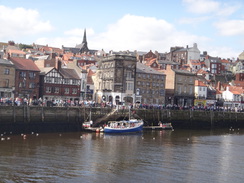
From the whalebone arch, turn right to follow a path that runs alongside East Terrace on the right. As the road curves to the right, the official route carries straight on, soon curves sharply to the left and then right in two big hairpins, descending down to reach the harbourside. Continue south along this road; buildings on the left mostly hide the water. The road curves to the left and then right to run alongside the riverbank before a lift bridge over the river is reached in the centre of Whitby at NZ899110.
Turn left to cross the bridge and continue on the other side. As the road curves to the right, turn left down Church Street. At the Board Inn, turn right to head up Church Lane; after a few yards a series of 199 steps lead up onto the clifftop to the east of the town. At the top follow the path as it passes St Mary's church on the left and go through a gate to reach a car park beside the ruins of Whitby Abbey on the right.
Turn half-left to head diagonally across the car park to join the access road. Immediately after the road curves to the right, turn left down a footpath. This slowly curves to the right and passes seaward of a series of buildings. When the surfaced path ends at a gate, turn left down a path that skirts a fence on the right. It squeezes past a wall into another field and follows a fence on the right. The path passes a caravan park on the right and descends some steps to reach a track that climbs up to run through the middle of the caravan site.
Follow the track as it heads through the caravan park. When it rejoins the clifftop once more, turn left to join a footpath. Go through a clapper gate and follow a fence on the left. At the end of the field go through a second clapper gate and continue following a fence on the left to reach the corner of the field. Here go through a third clapper gate down a little dip and up the other side to reach a fourth clapper gate. The path descends some wooden steps before climbing once more along the edge of the field. It climbs to reach a stile, and then runs between two fences to another stile. Some steps lead down to cross a boggy area, after which the path rises once more to pass seaward of a foghorn. The path continues on to reach the wall protecting Whitby Lighthouse at NZ928101.
At the wall, turn right to head uphill with the wall and lighthouse to the left. Cross a stone stile that leads to the access road to the lighthouse. Cross the road and climb steps that lead to a squeeze stile. The path curves to the left to follow a wall on the left eastwards. The wall ends and the path continues on; it drops downhill and climbs up steps to reach a small summit. The path then descends, following a fence on the right. Go through a pedestrian gate through a stone wall and follow a fence on the left downhill to reach a short but steep ascent. Cross a stile at the top and follow a fence on the right. Soon there is another stile; cross this and follow a hedge on the left to another stile. Go down some steps to another stile, and then down some stone steps to reach a stream at NZ933090.
Cross the stream and climb up stone steps on the other side. A flat level stretch heads on along the edge of the cliff before more steps lead down into trees. Cross a footbridge over a stream and then climb up wooden steps before climbing to enter another field. Follow a fence on the right along another relatively level section, before the path curves to the right and heads down steps into another wooded gully. Go through a pedestrian gate and cross a footbridge over Oakham Beck at NZ940082.
A path slopes up out of the gully into a field. It shortly descends into another gully at Limekiln Slack via steps and crosses a stream on a stone bridge, before more steps lead back up into a field. The path follows a fence on the right, climbing steadily. It crosses a shallow gully; the path curves to the right and continues climbing, and then curves to the left. As the path starts to fall a clapper gate is reached; this leads to steps and a slope that leads to a stream in Rain Dale. Cross the stream on a footbridge and climb out of the gully. Continue following the cliffs on the left as they curves around to take a more southwesterly heading.
Descend to cross another gully at Ness Ruck, and then another at Bay Ness, with an old railway trackbed off to the right. Soon a pedestrian gate leads through the fence on the right; this is a diversionary path due to coastal erosion. On the other side turn left to follow a fence on the left to reach another clapper gate that rejoins the original path. Follow the fence on the right to a pedestrian gate; the path passes hedges on the right belonging to houses. It emerges through a pedestrian gate onto a road called Mount Pleasant North. Follow this road westwards for a short distance until it ends at a T-junction with the B1447 road in Robin Hood's Bay at NZ950054.
Here the Cleveland Way is left behind; turn left to start following the B1447 road as it climbs steeply out of the village. After a third of a mile the road curves to the left; the Hook's House campsite is on the left immediately after the bend.
 |
 |
|
Distances
| From | To | Distance (m) | Ascent (ft) | Descent (ft) |
|---|---|---|---|---|
| Rock Cliff, Boulby | Staithes | 2.2 | 62 | 702 |
| Staithes | Runswick Bay | 3.4 | 479 | 492 |
| Runswick Bay | Sandsend | 5.1 | 712 | 725 |
| Sandsend | Whitby | 3.2 | 404 | 417 |
| Whitby | Hook's House Farm | 7.3 | 1207 | 833 |
This makes a total distance of 21.2 miles, with 2864 feet of ascent and 3169 feet of descent.
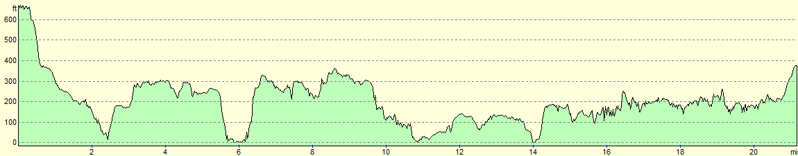
For more information on profiles, ascents and descents, see this page
Accommodation
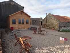
I spent the night at Hook's House Farmcampsite and caravan site, situated on the hillside above Robin Hood's Bay at NZ946057. The site cost between £7 and £9 per person per night; it was well worth the money as it was one of the friendliest campsite I have stayed at for years.
They can be contacted on 01947 880283.
 |
 |
|
 |
 |
|
 |
 |
|
 |
 |
|
 |
 |
|
 |
 |
|
 |
 |
|
 |
 |
|
 |
 |
|
 |
 |
|
 |
 |
|
 |
 |
|
 |
 |
|
 |
 |
|
 |
 |
|
 |
 |
|
 |
 |
|
 |
 |
|
 |
 |
|
 |
 |
|
 |
 |
|
 |
 |
|
 |
 |
|
Disclaimer
Please note that I take no responsibility for anything that may happen when following these directions. If you intend to follow this route, then please use the relevant maps and check the route out before you go out. As always when walking, use common sense and you should be fine.
If you find any information on any of these routes that is inaccurate, or you wish to add anything, then please email me.
All images on this site are © of the author. Any reproduction, retransmissions, or republication of all or part of any document found on this site is expressly prohibited, unless the author has explicitly granted its prior written consent to so reproduce, retransmit, or republish the material. All other rights reserved.
Although this site includes links providing convenient direct access to other Internet sites, I do not endorse, approve, certify or make warranties or representations as to the accuracy of the information on these sites.
And finally, enjoy your walking!
Nearby walks
| # | Title | Walk length (miles) |
|---|---|---|
| 236 | Redcar to Runswick Bay | 17.2 |
| 237 | Runswick Bay to Robin Hoods Bay | 14.9 |
| 238 | Robin Hood's Bay to Cayton Bay via Scarborough | 18.7 |
|
|

|