Walk #963: Cleveland Way: Robin Hood's Bay to Filey Brigg
 |
 |
|
General Data
| Date Walked | 09/09/2012 |
| County | North Yorkshire |
| Start Location | Robin Hood's Bay |
| End Location | Filey Brigg |
| Start time | 06.35 |
| End time | 19.15 |
| Distance | 25.3 miles |
| Description | This was a long but rewarding walk following the Cleveland Way to its southern terminus on Filey Brigg, passing through Scarborough on the way. The route is nearly all coastal walking, with grand and varied views available for much of the time. |
| Pack | Today I carried my Macpac Glissade rucksack containing my North Face Westwind tent, spare clothes, waterproofs, water, and some food. In total it weighed about thirty-five pounds. |
| Condition | I feel very tired after this walk, and had walked perhaps as far as I could during the day. I have np physical problems, including no blisters. |
| Weather | Today was generally sunny and very hot, and only a few welcome clouds helped keep the sun away for all-too brief periods. There was not much breeze to help cool me down. |
| OS map | Landranger number 94 (Whitby & Esk Dale, Robin Hood's Bay) and Landranger number 101 (Scarborough, Bridlington & Filey) |
 |
 |
|
Map of the walk
Maps courtesy of Google Maps. Route for indicative purposes only, and may have been plotted after the walk. Please let me have comments on what you think of this new format. For a detailed table of timings for this walk, please see the table file.
 |
 |
|
Notes
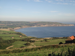
I awoke early and quickly started to pack up all my kit ready to go. The campsite was slowly waking up around me and the guttural noise of an early-morning car engine seemed particularly rude. I tried to make as little noise as possible as I pulled down my tent, shouldered my rucksack and headed off down the road. It was about a mile down to the shoreline in Robin Hood's Bay, and soon I had a choice to make.
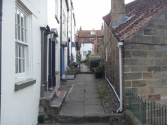
It is possible to miss the first two minor climbs of the day by following the beach south to Boggle Hole or Stoupe Beck, but this can only be done at high tide. Although the tide was rising I felt there was enough time to take the beach route, but I really wanted to do the trail's official route over the cliffs. I explored the picturesque village for a couple of minutes before starting the first climb.
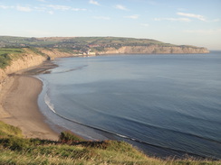
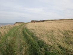
The path remained high for only half a mile before descending down steps to reach the Mill Beck and Boggle Hole. This is more famous for the YHA that nestles in the valley behind the beach, but the area was deserted as I crossed a footbridge over the beck and started another climb. Thankfully it soon levelled out, but all too soon it descended once more to reach Stoupe Beck. Another footbridge led over the beck before a track led uphill to reach a road. A path rejoined the cliffs, from where there were great views back towards Robin Hood's Bay.
A long ascent followed inland; at times this was steep and followed a track made of old bricks that were presumably from the brickworks that once existed nearby. Eventually Ravenscar came into view, and I sat down on a bench outside the National Trust shop for my first rest of the day. I used this opportunity to phone Sencan, who had spent most of the previous evening on the phone to a mutual friend.
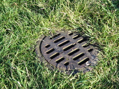
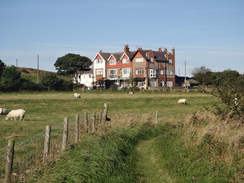
Ravenscar is an odd place; the majority was built in Victorian times as part of a new planned resort, similar in concept to Saltburn further up the coast. Sadly the concept of a resort at the top of 200-metre high cliffs with no beach below did not really catch on, and many of the house plots sold were never built upon and the scheme folded just before the Great War. A few houses were built near the pres-existing large hotel that is still extant; all that remains of the other plots are scattered lines of kerbstones and Victorian manhole covers that covered the sewers. Some of the houses that were built seem rather large and out-of-place in such a remote location.
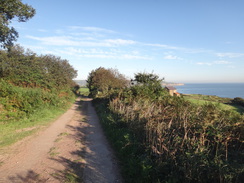
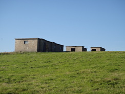
One of the unbuilt-on roads lead to a very pleasant stretch of clifftop walking. The houses of Ravenscar soon disappeared behind me, and some concrete buildings appeared on the right. These are the remains of an old Second World War radar site that had long been out of use. No masts interrupted the skyline, and only the information board gave me a clue about the buildings' original purpose.
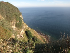
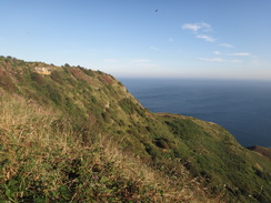
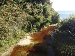
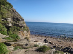
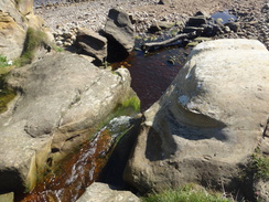
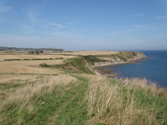
What followed was a very pleasant and easy stroll along a cliff top path, with some grand views out to sea. The cliffs slowly fell in height, and soon the most feared climb of the day came into view. A set of steep steps led down towards Hayburn Wyke. I stopped at a footbridge over a stream, thinking that this was the bottom. However a very short climb was followed by a descent to another footbridge over the Hayburn Beck. Three men were talking nearby, and I diverted off the path to say hello. It was quite a magical little spot: the beck runs over a little ledge onto the pebble beach, but I did not want to take my pack off to take some photos. Instead I chatted to the men for a few minutes. They all knew the area well, and were on different walks.
The feared ascent up the other side of the valley was not as bad as I feared, partially because the trees kept the worst of the sun off me, and partially because I set myself a target of keeping up with some other walkers in front of me. I eventually caught up with them and we exchanged some puns at the gate that led into the field at the top.
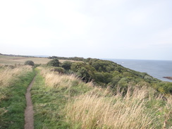
A gentle climb along the cliff edge was followed by an equally gently descent. A couple of little valleys had to be negotiated near Cloughton Wyke, and I stopped at a bench near the top of the first of these and took my boots off to allow me feet to cool. It was a pretty spot to stop and I watched walkers stroll past. Only when a couple disappeared up the other side of the valley did I realise I had taken the wrong path, having climbed up towards a little car park rather than sticking to the cliff edge. The problem was easily fixed by following the edge of a field for fifty yards back to the cliff edge where I could rejoin the proper trail.
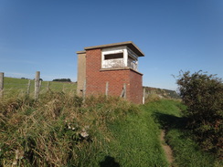
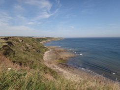
Several other minor valleys had to be negotiated along the edge of the cliffs. An old coastguard building at Long Nab was now in use as a bird hide, and from there the path continued south. I was feeling pretty tired by now and I wanted to stop, and the best place seemed to be at Scalby Ness, where there is a pub. A farm on the right showed that I was nearing the headland, but something seemed wrong; the ness was still not in view. The reason soon became obvious: the buildings I had passed were new and not marked on the map, whilst the proper farm was another half-mile south. People joined me as I struggled along in the heat, some carrying inflatables or surfboards down towards a small patch of beach.
The path climbed up and cut across the headland of Scalby Ness. Down to my right was Scalby Beck, which seemed to be almost cutting the headland off from the sea. More people were out now, and I had to stop on the descent to allow people to clamber past. Eventually I reached the footbridge across the beck and made my way towards the pub. The area outside it was packed and the queue of people awaiting drinks was well out of the door. Since there was nowhere to sit outside anyway, I decided to press on to see if I could find anywhere to stop in Scarborough itself.
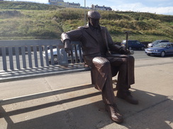
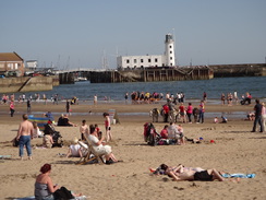
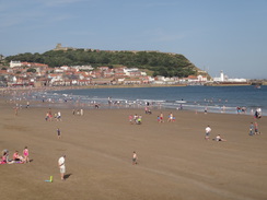
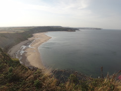
The beach was heaving in the autumnal heat and progress along the promenade was difficult at times due to the volume of people. A kiosk outside the Sea Life Centre did not have a great choice of ice creams, but I was soon munching on a Cornetto as I continued along, passing the supports of an old chairlift up the cliffs that was now sadly sans wires. A small-scale steam engine was pulling carriages packed with people across the hillside to the right, the sound of its whistle puncturing the air.
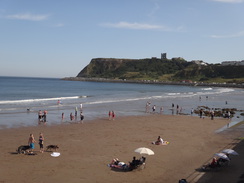
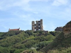
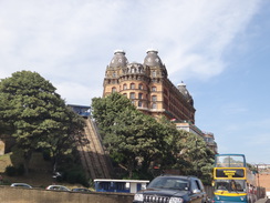
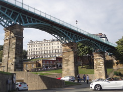
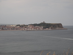
I had run out of water by this stage, so I nipped into a convenience store to buy a couple of bottles of water. It was stifling inside the store, and a long queue of people were waiting to buy water and ice creams. I nearly fainted from the heat and it was a relief to get outside, where there was at least a slight breeze to cool me. A promenade follows the Marine Drive around the castle headland in Scarborough; on my coastal walk I did not follow this and instead climbed up to visit the castle before dropping down to the harbour. There was no way I was going to be doing the extra climb with my heavy pack, so instead I followed Marine Drive around.
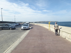
The road was bustling with traffic, most of which appeared to be looking for parking spaces. Information boards provided me with the story of the road's construction; it was very late and over overran on cost by the time it was completed. Signs warned that the road ahead was closed for traffic heading in my direction, and eventually I came across a compound where a large underground chamber was being constructed to store sewage overflow during heavy rainfall. A more recent renovation of the road and sea defences was also over time and over budget, showing that some things never change.
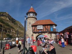
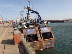
The promenade alongside the road was busting with people, but the situation got even worse as I approached the old harbour. Boats offering trips out of the harbour seemed to be doing a roaring trade, and the beach was heaving with people. Already I was planning what to do for the rest of the day. Before I set out on this trip I had planned to stop the night in the town, but as I was six or seven miles ahead of schedule it seemed sensible to walk on. What is more, I did not fancy trying to find accommodation in the town when it was so busy.
All the pubs were heaving, and I passed the magnificent Grand Hotel without finding anywhere to stop. Eventually I gave in and sat down on a quiet area slightly beyond the Spa complex. The reason it was so quiet was because it was beside some bins, but these were not smelly and the adjacent cliffs offered me shade. I took my boots off and lay back, thinking. I was only ten miles or so from the end of the trail at Filey Brigg, but that seemed too far to stroll today.
Fortunately there was a campsite about five or six miles further on, and that would leave only three or four to reach the end of the trail the next day, hardly with bothering about. I phoned the campsite who told me that they would have a pitch, but that the office closed at six. This left me two and a half hours to walk five miles; ordinarily this would not be a problem, but after an already-long day, and over hilly terrain, it was going to be tight. Reluctantly I shrugged my rucksack back onto my back and headed off.
The trail crossed an area of grassland that was once the site of the Holbeck Hall Hotel, a hotel that collapsed in 1993 when the slope underneath it failed due to soil creep. The resultant flow of a million tonnes of glacial till extended the land out to sea by 100 metres. There is a slight link with my family: my parents were due to stay in the hotel a week after the collapse. Needless to say, their booking was cancelled.
At the top of the cliffs I diverted off to see if I could find somewhere to fill my water bottles. There was no pub, but in the little car park there was a food van. I joined a queue, but the woman in front of me ordered several rounds of sandwiches which seemed to take an age to make. When my turn eventually came, I bought three bottles of water out of the chiller and a bottle of Ribena. It did not take me long to swig down the Ribena and fill my bottle from the smaller bottles before heading off.
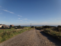
The trail remained high on the top of the cliffs as it passed a golf course. Sadly it did not remain that way, and soon steps led down to a track that sloped down to the foreshore. It followed the track back up to the top of the cliffs before continuing on. Sadly I knew that it would not remain high for long, as the map showed the path heading downhill through woodland. However a sign by a static caravan park stated the coastal path was closed and that a diversion headed uphill towards the road in Osgoodby.
I met a couple of the road who were keen walkers, and we chatted for a few minutes about the trail before I set off once more. The trail did not remain high, and soon a path led away from the road, descending through trees down Cayton Cliff. It was a pleasant walk but I was too tired to take in the scenery and was more concerned about the rest of the walk. The beach became visible far below and many people were still enjoying the sun's rays; I envied them their carefree day.
A steep climb led out of the woodland back onto the cliffs near a little caravan park. People were walking up from the beach carrying a cornucopia of beach objects: sunshades, buckets, spades, various inflatables and even small surfboards. An easy climb followed along the edge of the coast, with some grand views back up the coast towards Scarborough. I found it an easy and enjoyable stroll despite my fatigue, and soon I was gently descending alongside fields to reach Red Cliff Point.
The path followed the cliff edge towards a couple of caravan parks before climbing uphill towards them. It was not a bad climb, and soon I was faced with yet another decision. It was a few minutes before six and hopefully the site office would still be open. However I did not know where it was or how to get to it. Besides, from here on it was a pleasant and relatively level clifftop walk as far as the end of the trail at Filey Brigg, and there was still more than enough daylight in which to complete it.
Instead of ending the walk at the campsite, I decided to continue on to Filey Brigg. I knew there was a campsite right beside the Brigg, but my phone call was not answered. Two ladies were lying down at the edge of cliff and peering intently out to sea; one called out to me as I passed, and asked if I had any binoculars. Some seals were frolicking about on the rocks slightly out to sea, and the ladies had been watching them for a couple of hours. I had not taken my ocular with me on this trip, and I regretted that decision now.
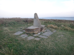
My feet were overheating once again, and as the cliffs started to curve around I looked for a place to stop for a few minutes. I tried the campsite again but there was still no reply; I started to resign myself to wild camping on Filey Brigg. This is quite a busy and scenic area, so it was hardly going to be the most unobtrusive wild camp. My feet soon cooled down, so I put my boots back on and continued along the cliffs, which were slowly lowering in height. The buildings of Filey were visible off to the right, as was the campsite; soon afterwards I came to the stone seat that marked the end of the Cleveland Way and start of the Wolds Way.
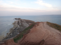
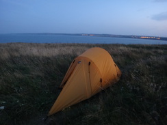
There was still about half an hour of daylight left, so I strolled down to the tip of the headland and looked out over the Brigg itself - the low-lying tidal land that stretches out into the sea. There was no way I was going to clamber down the steep cliffs to reach the Brigg, and so I walked slightly back along a side path to try to find somewhere decent to camp. About fifty yards away there was a concrete pad that was surrounded by metal rings, obviously some tie-down points for whatever was originally on the pad. There was a level section a few yards away, and I placed my pack down on the pad as I awaited dusk.
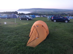
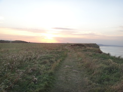
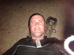
A few people were still wandering about, and I chatted to a couple about the area and wild camping. Neither seemed to mind me being there, and a lady watched as I erected my tent, commenting that I seemed to have done it a few times before! It was very windy as the headland is more than a little exposed, but I lay down on the pad and used my boots as a pillow as I stared up at a perfect star display in the clear skies. A shaft of light from Flamborough Head lighthouse occasionally swept across the sea and the ground surrounding me, and a buoy flashed intermittently out to sea. It was a superb end to an enjoyable, if strenuous trip along the trail.
 |
 |
|
Directions
This walk starts off at Hook's House campsite at NZ945057. Leave the campsite and join the B1447 road. Turn right along the road and follow it as it immediately curves to the right to head downhill. Carefully follow the road as it enters Robin Hood's Bay. After 0.4 miles the road curves to the right and then left to pass the Grosvenor Hotel on the left, where the Cleveland Way is joined. Follow the road as it heads south downhill; 0.4 miles after the hotel it reaches the Bay Hotel at the bottom of the village.
Just before the Bay Hotel, turn right up the narrow Albion Street that heads between houses. When it ends, turn left up Flagstaff Steps and then up boardwalk steps. This leads out onto a flagstone path that runs along the clifftop. The path passes the end of a hedge on the right and then curves to the right; a few yards further on it turns left through a field gate. It runs between fences to another field gate and continues on before descending down steps to reach Boggle Hole at NZ954040.
Cross a track to reach a footbridge over Mill Beck near the YHA. On the other side, climb up the hill for a short distance to reach a road. Turn right along the road for about five yards and then turn left up some steps. These lead steeply up; the path follows a fence on the right and continues east-southeastwards along the cliffs. It passes several fields and becomes enclosed between fences before starting to descend once more, including a flight of steps to reach a footbridge over Stoupe Beck at NZ957035.
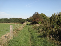
Cross the footbridge and follow steps that lead uphill, with a rocky track to one side. The path ends at a road beside Stoupe Bank Farm. Follow the road southwards for a couple of hundred yards; just after a right-hand bend turn left through a stone squeeze stile to join a path that runs between fences. The path soon meets the edge of the cliffs, and then turns right to parallel the cliffs with a fence on the right. Go through a pedestrian gate and follow the path, still with a fence on the right. It passes a bunker complex on the left, part of which is hanging over the cliff edge and presumably will not last much longer.
The path is quite easy to follow and not strenuous as it follows a fence on the right. It passes a pedestrian gate at NZ966026 to enter the Ravenscar property and then crosses a footbridge over a stream. The path curves to the right inland alongside the fence, then to the left to a second footbridge, then right once more to continue inland. The path then joins a track at NZ970021 beside a field gate.
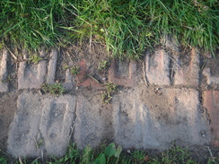
Turn left to join the track and follow it as it climbs uphill for a third of a mile. At NZ974018 turn right to join a gravel path that climbs steeply uphill through a gorse-laden hillside. The gorse ends and the path continues through trees before curving slightly to the left to meet a track. Turn left down this track and follow it as it continues to climb eastwards. Some of this track is made of bricks, presumably from the local brickworks. The track curves to the left and the gradient slackens as it gains a north-easterly heading; it becomes an access track to a house on the left, passes a National Trust shop and then ends at a road junction of Raven Hall Road and Station Road in Ravenscar at NZ980016.
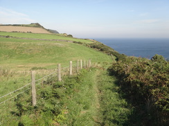
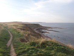
Turn right to head southeastwards along Station Road to pass a cottage on the right, and then turn left along a rough track called Hammond Road. Follow this as it heads towards the cliffs; it becomes grassy for the last few yards to the cliff edge, where a path leads off to the right along the edge of the cliff. This winds around as it generally parallels Station Road across the field to the right. When the field ends the path continues on, following a fence on the right. It passes an old radar station in the field to the right at NZ991008.
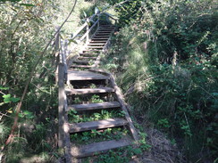
The path continues to gently fall; it goes through an area covered with ferns before opening up once more and reaching a short but steep descent down steps. At TA009978 the path passes through a pedestrian gate and then falls and rises across a dry gully. It continues to gradually fall as it passes Red House Farm in a field to the right. At TA009973 cross a stile and start heading down steps and wooden stepladders downhill.
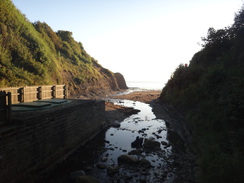
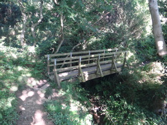
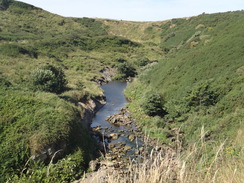
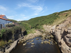
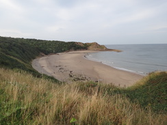
This leads to a causey path after which the path climbs slightly before falling down more steps to reach a footbridge. On the other side steps lead up for a short distance before descending to reach a second footbridge, this one over the Hayburn Beck at TA009970. Just off to the left is the small beach at Hayburn Wyke, where the stream trickles down a little waterfall onto the beach.
Cross the footbridge and start climbing uphill. After a short distance turn left up another path; this soon hairpins past a viewpoint on the left and continues through the trees. Shortly afterwards it curves to the right and heads up more steps. At a junction with another path it curves to the left to continue uphill before emerging out onto the clifftop at TA009968. Turn left to follow the path as it runs along the cliff edge; it slowly climbs for half a mile to a summit before starting a long descent.
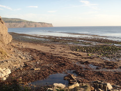
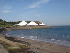
The path descends steeply down stone steps into Sycarham Wood and then climbs up stone steps on the other side of the valley. It levels off for a few hundred yards before descending down steps into another gully, crossing a stream and continuing on. At the end of the next field the path descends into a valley by Salt Pans at TA019952. Do not take the obvious path that curves away to the right inland, and instead climb uphill along a narrow path that follows the cliff edge before emerging out into a field.
At the end of this field go through a gap in a hedge to enter a second field. At the end of the next field the path descends steps into a gully and then ascends once more up steps. At the top the path curves to the left past Cloughton Wyke to head eastwards. Before long it descends a few steps to a footbridge over a stream in Hun Dale before climbing up the other side. After 150 yards steps lead down into another dry valley and out the other side.
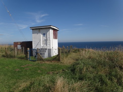
The going is easier as the path and cliffs head in a rough southerly direction for 0.6 miles from Hundale Point to Long Nab at TA092940, where the path passes landward of a white hut that was once the Long Nab Coastguard Station and Mine Shelter. After a third of a mile at Crook Ness the path curves to the right to head inland towards the end of a road; before it reaches the road the path turns left through a gap in a hedge and descends down stone steps to reach a concrete track in the gully bottom. Turn right along the track for about three yards, then left up more steps that leads out onto the cliff edge once more.
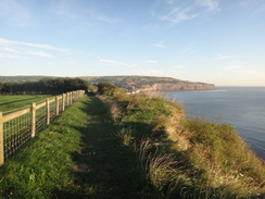
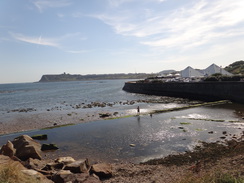
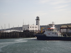
Follow the cliff edge in a rough southerly direction as it continues to gently climb, with occasional diversions for a few yards inland past the end of gullies. It passes seaward of some buildings on the right - perhaps a sewage farm - and then continues on towards Scalby Lodge on the right. Near the farm the path curves to the right past a little inlet before curving left to rejoin the cliff edge. It passes a footpath heading inland at TA031913 and starts climbing uphill. It reaches a headland with Scalby Beck down to the right; when the path forks at the top take the right-hand branch that cuts across the headland's neck. This leads to another path; turn right along this path and follow it as it starts descending down steps. At the bottom turn right to cross a footbridge over Scalby Beck to reach a road beside the Old Scalby Mills pub at TA035908.
On the other side of the bridge turn left to join the promenade and start following it as it heads southwards. It curves to the right to pass the Sea Life Centre and then gently curves to the left. After 0.8 miles it reaches a little roundabout and bus stop on the right; after this the promenade continues past the North Sands with the road on the right at TA037897. Initially the road heads southeastwards, but it slowly curves to the left as it follows Marine Drive under Scarborough Castle. The promenade and road then curves to the right past Castle Cliff to reach Scarborough Harbour, 1.5 miles after the roundabout.
The promenade starts heading along the east harbour wall; as soon as possible drop down some steps on the right and turn right past a cafe on the right to reach a road. Turn left down this road for a few yards to reach a roundabout at TA050887. Continue along the pavement beside the road as it heads westwards with the harbour to the left. The road and pavement curve to the left and pass the RNLI lifeboat station on the left, where the pavement becomes a promenade. The promenade takes a more southerly direction as it passes beneath the Grand Hotel, after which the road diverts inland whilst the promenade continues on past the Spa Complex. Shortly after the spa complex, descend down onto a lower promenade on the left. 1.3 miles after the lifeboat station, the promenade reaches a large arc of grassy land that is the remains of the Holbeck Hall landslip at TA049870.
Walk halfway across the grass and then turn right to head uphill along a wide path towards the top of the cliffs. At the top ignore paths leading up to the right towards a hidden car park, and instead turn to the left to continue along the path that follows the top of the cliffs. It passes between bushes which open out onto a golf course on the right. It descends down steps to reach a track; turn right to start following the track steeply uphill. When it reaches a car park at the top next to a water compound at TA057860, turn left to follow the path as it continues south along the cliff top.
It passes some woodland and then crosses a boardwalk to enter a field. Follow the edge of the field; the going is more or less level until it reaches some houses. Here the trail is diverted away from the route on the map; turn right to head up a path with the houses on the left and a fence on the right. After 250 yards the path reaches a clapper gate that leads out onto Filey Road in Osgoodby at TA058852. Turn left to start following the road uphill to the southeast; there is a pavement on the left. The road crests a slight hill and starts falling; keep on the pavement on the left. After a quarter of a mile a path leads down to the left through a gap in a fence at TA060848 to enter some woodland.
A series of steps lead downhill into a wooden valley, crossing a boardwalk and falling some more before undulating and curving to the right through the trees. The path is easy to follow as it heads southeastwards, with a beach below to the left. It descends down more steps to reach a pedestrian gate at TA065845; go through this and turn left. The path then curves to the right and climbs uphill to reach a second pedestrian gate, after which steps lead steeply uphill to the top of the cliffs. At the top turn left through another pedestrian gate and follow a fence on the left. The fence soon curves away to the left and the path continues straight on down to a track at TA066843.
Cross the track and then head up steps and cross some grassland to pass to the left of a white cottage. The path passes a field before curving to the right away from cliffs. It turns left to follow a track on the right for a few yards to reach a path leading up from the beach. Cross the path and continue on along the clifftop, passing some houses on the right. A steady ascent follows up the cliffs; near the top it joins a fence on the right and follows this uphill, with the cliffs to the left.
It reaches a little summit and starts descending, including a flight of steps, to reach Red Cliff Point. Here the path curves to the right and starts climbing gently once more, heading towards a caravan park on the higher cliffs ahead. As it approaches the caravan park the path carries on through a fence and then curves up to the right, following a fence on the right. It joins a track in the caravan park and passes seaward of the caravans; as the track curves to the right continue straight on along a path. The caravans on the right soon end and the path continues out of the caravan park.
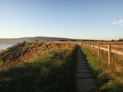
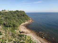
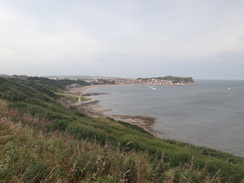
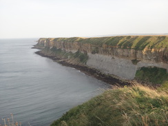
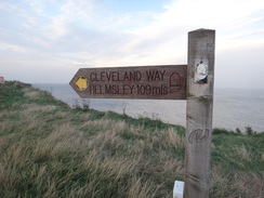
At the end of the caravan park the path curves to the right up five steps and then to the left to continue along the cliff edge. It crosses a little bank and curves to the right; go past the end of a fence and continue along the edge of Newbiggin Cliff. The going is relatively level and the path is of good quality. A couple of miles after the caravan park, the path curves to the right slightly away from the cliffs to reach a stone bench on the left at TA124816. This bench marks the end of the Cleveland Way.
I passed the bench and then turned left along another path that headed east along the top of the headland for a third of a mile; I camped near the eastern end at TA129815.
 |
 |
|
Distances
| From | To | Distance (m) | Ascent (ft) | Descent (ft) |
|---|---|---|---|---|
| Hook's House Farm | Ravenscar | 4.3 | 919 | 659 |
| Ravenscar | Scalby Mills | 9.6 | 833 | 1463 |
| Scalby Mills | Filey Brigg | 11.4 | 1132 | 1020 |
This makes a total distance of 25.3 miles, with 2884 feet of ascent and 3142 feet of descent.
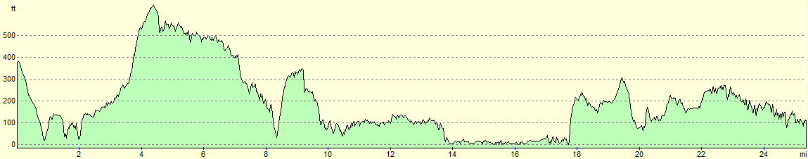
For more information on profiles, ascents and descents, see this page
Accommodation
I spent the night camping on the hadland just before Filey Brigg. This was hardly a remote and quiet wild camp, but no-one objected and the views as the sun rose in the monring were superb. There is a campsite about half a mile inland that will prove of use to most campers.
 |
 |
|
 |
 |
|
 |
 |
|
 |
 |
|
 |
 |
|
 |
 |
|
 |
 |
|
 |
 |
|
 |
 |
|
 |
 |
|
 |
 |
|
 |
 |
|
 |
 |
|
 |
 |
|
 |
 |
|
 |
 |
|
 |
 |
|
 |
 |
|
 |
 |
|
 |
 |
|
 |
 |
|
 |
 |
|
 |
 |
|
 |
 |
|
 |
 |
|
 |
 |
|
 |
 |
|
 |
Disclaimer
Please note that I take no responsibility for anything that may happen when following these directions. If you intend to follow this route, then please use the relevant maps and check the route out before you go out. As always when walking, use common sense and you should be fine.
If you find any information on any of these routes that is inaccurate, or you wish to add anything, then please email me.
All images on this site are © of the author. Any reproduction, retransmissions, or republication of all or part of any document found on this site is expressly prohibited, unless the author has explicitly granted its prior written consent to so reproduce, retransmit, or republish the material. All other rights reserved.
Although this site includes links providing convenient direct access to other Internet sites, I do not endorse, approve, certify or make warranties or representations as to the accuracy of the information on these sites.
And finally, enjoy your walking!
Nearby walks
| # | Title | Walk length (miles) |
|---|---|---|
| 237 | Runswick Bay to Robin Hoods Bay | 14.9 |
| 238 | Robin Hood's Bay to Cayton Bay via Scarborough | 18.7 |
| 239 | Cayton Bay to Flamborough North Landing via Filey | 16.9 |
|
|

|