Walk #960: Cleveland Way: Oakdale Upper Reservoir to Kildale
 |
 |
|
General Data
| Date Walked | 06/09/2012 |
| County | North Yorkshire |
| Start Location | Oakdale Upper Reservoir |
| End Location | Kildale |
| Start time | 06.55 |
| End time | 17.34 |
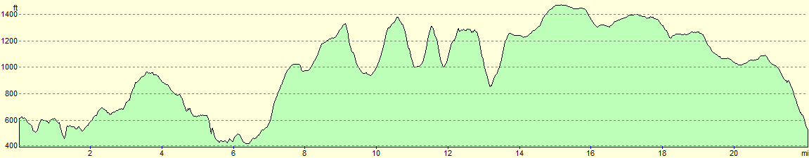
| Distance | 22.1 miles |
| Description | This strenuous walk follows the Cleveland Way as it heads eastwards along the northern edge of the North Yorkshire Moors. There are a number of very steep climbs and descents to be made before the trail turns to head north from Bloworth Crossing, slowly descending off the moors towards Kildale. |
| Pack | Today I carried my Macpac Glissade rucksack containing my North Face Westwind tent, spare clothes, waterproofs, water, and enough food for three days. In total it weighed about thirty-five pounds. |
| Condition | I am very fatigued after this walk, but otherwise feel fine. |
| Weather | The day started cloudy, and although some of this blew away during the day, the sunny periods were not thankfuly not too frequent. It was quite a warm day, and there was little breeze to help cool me down. |
| OS map | Landranger number 100 (Malton & Pickering, Helmsley & Easingwold), Landranger number 99 (Northallerton & Ripon, Pateley Bridge & Leyburn), Landranger number 93 (Middlesbrough, Darlington & Hartlepool) and Landranger number 94 (Whitby & Esk Dale, Robin Hood's Bay) |
 |
 |
|
Map of the walk
Maps courtesy of Google Maps. Route for indicative purposes only, and may have been plotted after the walk. Please let me have comments on what you think of this new format. For a detailed table of timings for this walk, please see the table file.
 |
 |
|
Notes
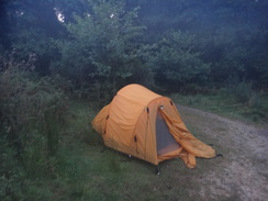
I woke up after a good night's sleep and lay in my sleeping bag for a while before getting up and striking camp. I always find wild camping slightly nerve-wracking, especially when I camp so near to a track, but as usual no-one had said anything and my concerns had been unnecessary. Some grouse were strutting around nearby as I sat on the ground with my pack, and they ran off as I stood and shouldered my load. I felt more than a little nervous as I set off: I had not eaten enough last night and was well aware that there was not going to be anywhere to stop for a bite to eat all day. However my rucksack was still packed with food, so there was always the option of stopping somewhere and cooking some food if time allowed.
A farmer was just setting off on his quadbike from Oak Dale Farm, showing that I had set off just in time. I caught a quick glimpse of Oak Dale Lower Reservoir for a couple of seconds before the track climbed steeply uphill through trees to meet a road; the ascent proved rather hard on my cold legs.
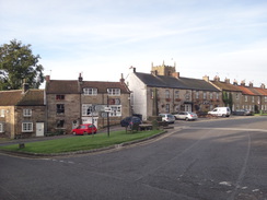
Another descent along paths took me into a steep-sided valley before steps climbed out once more. The rough terrain was not problematic but would have proved difficult at the end of yesterday's walk in the gloomy dusk light, proving I had made the correct decision in not trying to reach Osmotherley. The trail suddenly burst into the village with pleasant stone cottages arrayed around the village green. This was the last village of any size I would pass today, so I shrugged off my rucksack onto a bench whilst I took stock of my situation.
Annoyingly the public toilets were not yet open, and the shop was not due to open for another hour. Fortunately I had plenty of provisions, but my biggest problem was water. I would pass little if any habitation during the day, and the handily-situated cafe near Carlton Moor was closed all year. Children were gathering to await a bus to school as I pondered the problem. A man came out of a nearby pub, and he kindly agreed to let me use the garden tap. It proved difficult to fill the narrow-necked bladders using the hose, but eventually I had two full bottles, hopefully enough to last me the day.
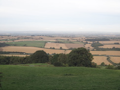
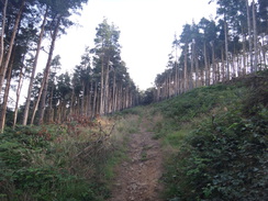
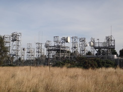
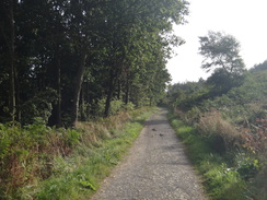
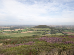
Back at my rucksack, I had a decision to make. There seemed little point in waiting for the shop to open, and instead I headed off up the road. A good track led away from the road towards a farm, after which a path headed north towards a forest. Here a sign indicated that the next few miles also followed the route of the Coast-to-Coast walk, a trail that I have never really felt like walking. A steep climb through the woodland led to a large microwave relay station, with large dishes pointing in various directions. The views ahead were starting to open out, and the solitary summit of Roseberry Topping, still more than a day away, was clearly visible in the distance. An arc of hill summits lay between, all of which would have to be negotiated over the next day.
This marked the summit of the day's first climb, and many were to follow. A good path led out of the forest and across Scarth Wood Moor, and this was a very enjoyable stroll until the descent steepened and steps led down to a road. On the map, the trail headed uphill for a short distance before heading through another area of woodland. The fingerpost marking the path from the road had no acorn symbol denoting the trail, and the driver of a conveniently-placed digger told me that the trail was now routed further down the road. I was rather sceptical about this, not the least because it meant that the short climb uphill had been unnecessary.
I headed back to the road and descended to a cattle grid, where an acorn symbol told me that the digger driver was correct. The new path was broad and easy to follow as it headed through the trees on what was a rather gloomy if relatively level stroll. It ended at a road that in turn crossed a stream to reach a road junction that marked the start of the second climb. This started easily as a gently path led along the edge of some woodland. Sadly this was soon to end as the path cut steeply uphill through the trees. I was soon gasping for air and it was a relief when the path burst out of the trees and the gradient slackened slightly.
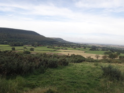
A slight descent from the top of the hill led to a long and steady climb up Faceby Bank to reach the 408-metre summit on Carlton Moor. I was quite tired by the time I reached this point, and the steep descent down to the road did not improve matters. Fortunately a short and level stretch followed, and this gave my legs a chance to recover slightly. A building site off to the right marked the site of the cafe which appeared to be in the middle of reconstruction. This was expected but a great shame - it would have been an ideal place to take a break on this long day's walk.
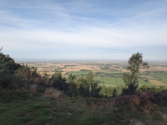
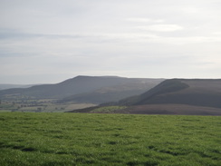
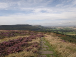
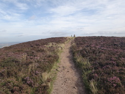
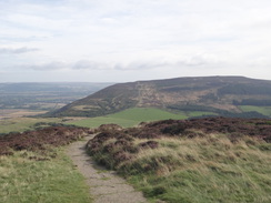
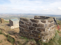
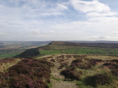
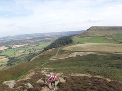
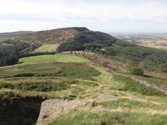
Another steep climb took me up to the summit of Cringle Moor. On a shorter walk and with a lighter pack this would have been a delightful stroll; however with my heavy pack it was unenjoyable and the spectacular views were hardly compensation for the effort. A mountain biker was struggling up behind me, and he stopped at the viewpoint and little stone wind-shelter as I toiled on to the highest point of the hill. Given the steepness of the terrain I wondered why he had taken this route whilst an easier path was clearly visible on the flank of the hill below.
The cyclists overtook me as I headed down a steep section, his bike hoisted high on his shoulder. We met at the bottom of the hill where he was intently studying his map. He had misread it and climbed the hill by mistake having ignored the 'no bikes' sign! After chatting for a few minutes we parted company and I started yet another climb. This took me up a steep hillside that had little rewards, before it dropped me back down to a gap.
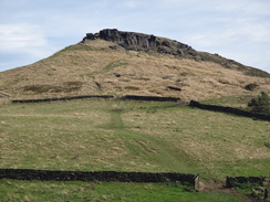
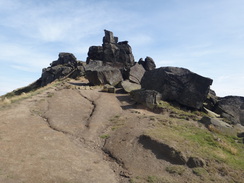
Large piles of rocks loomed overhead, the rocky outcrop of the Wain Stones. As I toiled up the slope towards the stones I watched people climbing up the rock faces, and I wondered what they thought of the idiot clambering uphill with heavy pack. The path became indistinct as it passed the stones, with many different tracks leading off in different directions. I chose what appeared to be the most prominent path that took me over the northern flank of the hillside.
It soon petered out, and instead of turning around and heading back the short distance to find the proper path I decided to head straight up the steep slope, a climb of perhaps thirty feet. This proved an unwise decision with my heavy pack and I could only stop myself from falling backwards by grasping onto the vegetation. It was an indication of my fatigue that my natural caution had disappeared. More by luck than judgement I reached the summit and joined the proper path.
By this time my calves were burning, a rarely-felt indication that I had not eaten enough today and that I was running out of energy. A flat stretch of trail at the top of the hill gave me a chance to munch a chocolate bar in a vain hope that my legs would respond quickly. Sadly it did not help and my calves screamed throughout the steep descent to meet a main road in a gap. Once by the road, I took my pack off and sat down on the ground as I stared at the next steep climb.
My poor decision-making by the Wain Stones had shaken me, and I wondered if I was in a fit state to continue on. The only other option was to walk the two and a half miles down to the village of Great Broughton, which would make the next day's route rather troublesome. I munched another chocolate bar whilst I contemplated both unattractive options. I transferred water from the spare bottle into my drinking bladder whilst staring at the ominously steep hillside that rose up in front of me.
However I tried I could not make the diversion off to Great Broughton work. I walked around for a couple of minutes to test my legs, which felt far less rubbery after the short rest. What had seemed impossible just twenty minutes before now seemed the best option: to continue on. I was soon panting up the first part of the steep ascent; this was only a 400 feet climb but it felt much worse, and I was relieved when the gradient slackened at the top. The path was easy to follow and proved good to walk along, and soon all my troubles evaporated away. Sadly the views were not as grand as they had been earlier on in the day, but I generally enjoy high moorland walks and this was no exception.
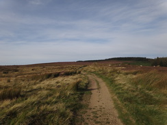
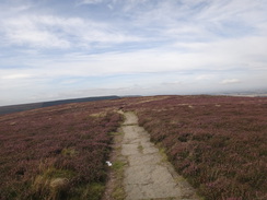
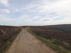
A gentle climb led across the moorland. A trig pillar was visible about a hundred yards away from the track on Round Hill, but I was too tired to risk the diversion. This marked the highest point of this stretch of the walk and ahead lay many miles of descent. Eventually the main track curved around and the path descended to cross a stream before climbing to meet another rough track.
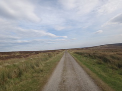
Regular indentations in the track's surface belied its original use - it was constructed as part of an old railway line that climbed up from Battersby Junction onto the moors. It is hard to believe it nowadays, but this high and wild moorland had several railway lines running across it, providing access to the mines that were scattered around the moors. The trackbed was followed for only a couple of hundred yards to Bloworth Crossing, where the line crossed a track across the moor. This marked the point where the Coast to Coast path heads across the moors, whilst the Cleveland Way continued north along the track.
An initial gentle climb was followed by an equally gentle descent. I was feeling very happy by this point and I knew I would have no problem completing the day's walk. The small hamlet of Kildale was easily within reach and I started thinking of what to do. One option was to walk a couple of miles past Kildale and wild camp somewhere near Easby Moor. That would mean another climb and wild camp, and I felt in need of a little luxury. Fortunately there is a camping barn just off the trail before Kildale, so I settled down into the heather and phoned them up. The farmer running the barn told me that there was only one other person was booked in for the night and that there was plenty of space.
Just as I hung up, another walker approached. His name was Colin and he was also walking the trail; what is more, he was the man who was also booked into the camping barn. We chatted for a few minutes before he set off; I wanted to talk to Sencan, so I settled back into the heather and phoned her up.
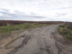
An RAF trainer prop-driven aircraft flew directly overhead as I set off, and it made a second pass as the track joined a road. The road was in terrible condition as it climbed slightly to a summit, with the tarmac badly broken and subsided in places. It reminded me a little of the closed road over Mam Tor, and although the damage was nowhere near as bad, I would not have wanted to drive a car over it.
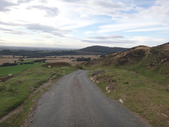
A steep descent took me downhill, the road condition slowly improving as it did so. Soon a footpath led off down to Park Farm and the camping barn. I knocked on the door and the lady showed me around; it was a basic but clean place, with cooker and even, luxury of luxuries, a TV. Colin was already lying on a mattress, and we chatted for a while before I got another mattress off a pile to use as my bed. With only two of us there was plenty of space, but we spent much of the evening chatting as we cooked and ate. It was a perfect ending to what had been a very hard day's walk, and one that had not been as enjoyable as the glorious scenery deserved.
 |
 |
|
Directions
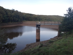
This walk starts on a track at the eastern end of Oak Dale Upper Reservoir at SE474961. Follow the track west, keeping the reservoir away to the left. It passes the dam and then rises up to a field gate through a stone wall; go through this and follow the track past Oak Dale Farm on the right. The track then descends to reach a pedestrian gate beside a cattle grid, with another reservoir just off to the left. It crosses a little bridge and then curves to the right and climbs steeply uphill through trees. It emerges from the trees and continues climbing, before levelling out as it continues northwestwards between fences to reach a bridleway gate beside a field gate. Go through this to reach a road at SE464968.
Turn left down the road for a few yards, and then right to join a gravel track that heads north. Ignore a couple of gates off to the left; shortly after the second turn left through a stone squeeze-stile to enter a field. A path leads downhill for a short distance to join a track that heads towards Whitehouse Farm; when the hedge on the right ends before the farm, turn right to head diagonally across a field, aiming for a corner of a hedge ahead. The path curves to the left past the hedge and descends past a stone wall on the right to reach a field gate. Go through this and continue downhill to a pedestrian gate. Pass a bench on the right and continue descending to reach a track.
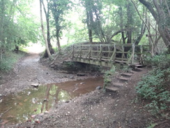
Cross the track and continue downhill to a footbridge over a stream. On the other side the path steeply ascends (sometimes on steps), and at the top goes through a squeeze stile. A few yards further on it goes through a clapper gate and follows a flagstone path between fences. Go through another squeeze stile and clapper gate combination, and then several more squeeze stiles before the path descends some steps to reach a road in Osmotherley. Cross the road and head straight on along a path that curves to the right and then left, before heading under a building to reach a road near Helmsley church at SE456972.
Turn right and start following the road uphill to the north. After a quarter of a mile turn left up Rueberry Lane. This heads uphill; ignore a track leading up to the right towards Lady's Chapel at the top of the climb and instead continue along the main track as it curves to the right to reach Chapel Wood Farm. It passes to the right of the farm to reach a clapper gate beside a field gate. Go through this and follow a hedge on the left northwards. At the end of the first field go through a clapper gate beside a field gate and continue on towards some trees ahead. A second clapper gate beside a field gate leads into the woods.
The path forks once through the clapper gate; take the right-hand branch. At this point it joins the Coast-to-coast path, which will be followed as far as Bloworth Crossing. The path climbs steeply through the trees; eventually the gradient slackens and the path climbs gradually, with a wall a short way away to the right. It goes through a pedestrian gate to reach a track that leads into a BT microwave relay station on the left. On the other side the path continues between the wall to the right and a fence guarding the dishes on the left; at the end of the complex the path goes through another pedestrian gate to emerge back into the woodland.
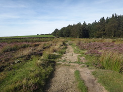
Continue following the wall on the right as the path heads through the trees and descends slightly to reach a pedestrian gate. Go through this and then turn left for a few yards to reach a second gate. On the other side of this follow an obvious path that heads east-northeastwards across Scarth Wood Moor. As the track curves to the right after two-thirds of a mile, turn left down a footpath that soon joins a wall on the left. The path and wall heads steeply downhill before levelling out and plunging downhill once more. It soon reaches a road at NZ473003.
Turn left to follow this road downhill for a short distance until it reaches a cattle grid. Go through a clapper gate beside the grid and then immediately turn right up a good path that enters some woodland. This path leads through the trees; after about a hundred yards it meets a track; turn left to follow this track through the trees. Under half a mile after leaving the road, a path leaves the track to the left; join this and follow it as it heads downhill to reach some steps. Eventually the gradient slackens out and it meets a track coming in from the right at NZ481008.
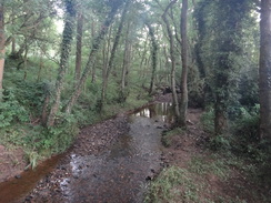
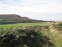
Turn left down this track for a few yards towards a field gate; just before the gate turn right down another path. This soon curves to the left and becomes slightly better quality as it enters the trees. It undulates as it head southwestwards through the trees; when it forks after two-thirds of a mile take the left-hand branch that heads down for five yards to reach a clapper gate. Go through this to enter a field. Head on across the field to reach a pedestrian gate beside a field gate. On the other side of the gate, descend down a stony track to reach a ford over the Sugdale Beck; there is a footbridge on the right. On the other side of the stream head up to join a minor road. Turn left along this road and follow it as it climbs, curving to the left to pass a farm at Hollin Hill and then right to end at a T-junction in Huthwaite Green at NZ492007.
Cross the road and turn right for a few yards, before turning left to go through a bridleway gate next to a field gate. This leads to a good path that runs between trees. It soon goes through another bridleway gate to enter a field, and curves to the left to head in a more northerly direction, with a tree-covered slope off to the right and a field on the left. The gradient steepens until the path curves to the right to reach a third bridleway gate that leads into the trees.
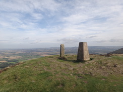
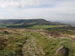
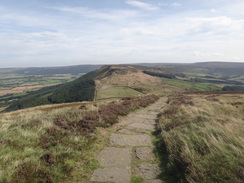
The path heads steeply uphill to the east through the trees, zigzagging along steps. It crosses a track and continues uphill for a short distance to reach a bridleway gate that leads out of the woodland. On the other side the path curves slightly to the left and continues to climb steeply. It reaches a summit on Round Hill before dropping slightly, then climbing up Faceby Bank. The path slowly curves to the left to take a more north-northeasterly heading, sometimes running along flagstones. The gradient slackens as it approaches the trig pillar on Carlton Bank; from here it descends steeply along a gravel path and stone steps over the steepest sections. Go through a clapper gate to reach a track; cross the track and continue straight on along flagstones to reach Raisdale Road at NZ523029.
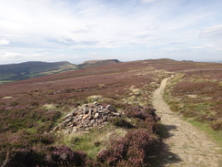
Cross the road and go through a pedestrian gate in a fence to reach a grassy path. This heads northeastwards; it joins a grassy track that skirts a car park and Lord Stone's Cafe on the right. When the path forks three ways, take the right-most branch and follow a fence on the right. Soon another fork is reached; take the right-hand branch to follow a stone wall on the left uphill. Go through a bridleway gate and follow stone flags uphill. It passes a little stone wind-shelter and viewpoint and curves sharply to the right to continue climbing towards the top of the hill. The path descends steeply down the eastern side of the hill, and at the bottom reaches a little bealach at NZ545033.
The path crosses a boggy area before starting to climb once more. When the path forks, take the right-hand branch; this curves to the right to reach a field gate. On the other side the path joins a stone wall on the left that soon curves sharply to the left. Follow the wall uphill to reach a clapper gate beside a field gate. The path climbs steeply uphill to reach a summit, and then drops equally steeply down the other side. It passes through a pedestrian gate and continues falling to reach Garfit Gap at NZ555034.
Go through a field gate at the bottom and climb up to a clapper gate. Steps then lead up towards a rocky outcrop called the Wain Stones ahead. Care needs to be taken at the top; climbers have created several paths around the flanks of the hill that can cause confusion. The path passes the first outcrop on the right and then curves to the left towards the main mass of rocks. Turn slightly to the right to head through the rocks to reach the top, where a good path continues climbing gently to the east. This path reaches the summit and then curves to the right to head southeastwards. Initially it gently falls, before turning to the left to zigzag steeply down the hillside eastwards. Squeeze beside a fence to reach a clapper gate, and then follow a wall downhill. A series of steps then leads to the B1257 Clay Bank Road at NZ572032.
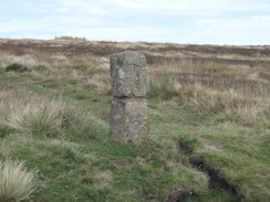
Carefully cross the road and take a stone path that leads through a gap in a low stone wall. The path follows a fence on the left for about ten yards to a bridleway gate. On the other side follow a stone wall on the left to a second bridleway gate. Go through this and continue uphill as the path slowly curves to take a more southeasterly course to reach pedestrian gate beside a bench. On the other side of the gate continue uphill; the gradient slackens until it reaches a small summit on the Carr Ridge. One and a half miles after the road at NZ586018, the path joins a track and curves slightly to the left to take a east-southeasterly course.
The track continues climbing for a third of a mile as it passes close to the trig pillar on Round Hill on the left; shortly afterwards it curves to the left to take a more easterly course and starts gently falling. At NZ609016 the track curves sharply to the left; here head straight on along a path that descends eastwards to reach some boggy ground and then a small stream. Cross the stream and climb up the other side for about a hundred yards until it reaches a track. Turn right to follow this track east-southeastwards for a quarter of a mile, passing a vehicle barrier to reach Bloworth Crossing at NZ615014.
Here turn left to take a track that heads north-northwestwards. This climbs slightly to reach a little summit before falling and climbing once more to pass the summit of Tidy Brown Hill. Shortly after this at NZ601049 turn right to go past a field gate and join a smaller track. Follow this track as it heads northwards. The track slowly falls and curving slightly to the right to take a more north-northeasterly course. 1.4 miles after the track junction the track climbs slightly to reach a pedestrian gate before a field gate, and then a few yards later a field gate guards a road at NZ610069.
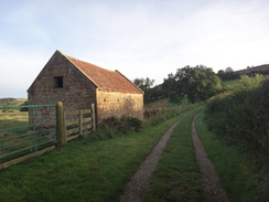
Head straight on along this road; initially it climbs northeastwards before curving to the left and falling steeply. 1.4 miles after joining the road the gradient slackens; here this route leaves the trail to reach the night's accommodation. On a right-hand bend at NZ605085 turn left across a stile to enter a field. Follow a fence on the left that heads downhill; at the bottom of the field follow a vague track to the right for about twenty yards and then turn left to reach a field gate that leads to Park Farm at NZ602084, where this walk ends.
 |
 |
|
Distances
| From | To | Distance (m) | Ascent (ft) | Descent (ft) |
|---|---|---|---|---|
| Oakdale Upper Reservoir | Osmotherley | 1.8 | 315 | 407 |
| Osmotherley | Huthwaite Green | 4.9 | 814 | 863 |
| Huthwaite Green | Clay Bank | 6.5 | 2188 | 1798 |
| Clay Bank | Bloworth Crossing | 3.3 | 689 | 240 |
| Bloworth Crossing | Park Farm, Kildale | 5.6 | 328 | 1102 |
This makes a total distance of 22.1 miles, with 4334 feet of ascent and 4410 feet of descent.
For more information on profiles, ascents and descents, see this page
Accommodation
I spent the night in the KIldae Camping Barn, which is situated at Park Farm, about a mile to the southwest of the hamlet of Kildale at NZ602084. This basic but perfectly functional campng barn cost £7.50 for the night; they also allow camping in the grounds for £4.50 a night. There are showers, and the family running it can provide sandwiches made ready for the next morning.
They can be phoned at 01642 722847 or emailed at parkfarm_2000@yahoo.co.uk.
 |
 |
|
 |
 |
|
 |
 |
|
 |
 |
|
 |
 |
|
 |
 |
|
 |
 |
|
 |
 |
|
 |
 |
|
 |
 |
|
 |
 |
|
 |
 |
|
 |
 |
|
 |
 |
|
 |
 |
|
Disclaimer
Please note that I take no responsibility for anything that may happen when following these directions. If you intend to follow this route, then please use the relevant maps and check the route out before you go out. As always when walking, use common sense and you should be fine.
If you find any information on any of these routes that is inaccurate, or you wish to add anything, then please email me.
All images on this site are © of the author. Any reproduction, retransmissions, or republication of all or part of any document found on this site is expressly prohibited, unless the author has explicitly granted its prior written consent to so reproduce, retransmit, or republish the material. All other rights reserved.
Although this site includes links providing convenient direct access to other Internet sites, I do not endorse, approve, certify or make warranties or representations as to the accuracy of the information on these sites.
And finally, enjoy your walking!
Nearby walks
| # | Title | Walk length (miles) |
|---|---|---|
| 715 | A circular walk from Rosedale to Hutton-le-Hole | 20.8 |
| 959 | Cleveland Way: Helmsley to Oakdale Upper Reservoir | 21.0 |
|
|

|