Walk #112: Melrose to Carfraemill
 |
 |
|
General Data
| Date Walked | 17/09/2000 |
| County | Borders |
| Start Location | Melrose |
| End Location | Carfraemill |
| Start time | 08.40 |
| End time | 15.35 |
| Distance | 14.7 miles |
| Description | This walk involved a climb over the hills following the Southern Upland Way, followed by five miles of track and road walking northwards. |
| Pack | Today I carried full Pennine Way kit. |
| Condition | I feel okay after this walk. My left calf is fine, indeed better than it has been for the last few days. I have no new blisters, and the Compeed plaster that I placed over the toe on my left foot that I was having trouble with yesterday has worked a treat. The biggest problem today was a general lack of stamina in my feet - after lunch in lauder my feet just started aching, and it got more and more painful as time passed after that. As soon as I got to me B&B everything was fine. |
| Weather | Today's weather was very good, and nearly ideal for walking. There was not much sun about, but the cloud cover was generally thin and was being blown away quickly by the wind. In the brief sunny periods it was quite hot but the wind kept me cool. When I was looking along the A68 at the end of the day there were a few brief spots of rain, and a beautiful rainbow formed nearby. Thankfully this was the only precipitation that fell all day. |
| OS map | Landranger number 73 (Peebles, Galashiels & Selkirk, Tweed Valley) |
 |
Map of the walk
Maps courtesy of Google Maps. Route for indicative purposes only, and may have been plotted after the walk. Please let me have comments on what you think of this new format. For a detailed table of timings for this walk, please see the table file.
Notes
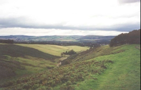
This was in the most part a lovely day's walk from Melrose into Laudaerdale. The first part consisted of a steady climb northwards out of Melrose which was highly enjoyable, with the Eildon Hills growing smaller behind me.
The initial section of today's walk, which followed the Southern Upland Way north of Melrose was not the most spectacular section of the trip, as even the highest sections were cultivated. However despite this it was still a lovely walk over the hills. It would have been nicer if there had not been so many power lines spoiling the views though!
I stopped for an hour in Lauder so that I could have a rest and a meal, and I had a nice chat with the barmaid of the Eagle Hotel and a customer, mainly about the fuel crisis that was causing many of the people in the are big problems.
When I left Lauder I walked along the old railway line for a few miles before it became very hard going (mainly because of crops that were growing over the line) so I cut across to the A68 at Blackburn Farm. Fortunately the A68 was very quiet, probably due to the fact that it was a Sunday and the fuel crisis was not yet over.
The B&B that I am staying in in Carfraemill is very nice - I had a lovely meal tonight with a home-made vegetable soup, a lovely steak braised in whisky and cream, and cheese and biscuits for afters. All in all this was a very nice meal that left me feeling very full.
Tomorrow I have the Lammermuir Hills to traverse, including the climb up to Crib Law and Lammer Law. The latter hill is at 527 metres the highest point of the walk so far. Fortunately the ascent onto the Lammermuir Hills is mostly a gradual slope along what was the old Herring Road (where the used to bring the Herring inland from the ports), although there appear to be some relatively steep sections onto Crib Law.
I still have not organised any accommodation for tomorrow night. It is apparently eleven miles to Gifford over the Lammermuir Hills, so I shall have some choice about whether I stay in Gifford or even try to struggle on to Pencaitland. Which of these options I do depends on how I feel when I have descended from Lammer Law.
The hills were very quiet today, and I only saw one other walker in the hills - a lady who was checking a route ready for a sponsored walk next weekend. I thought that this it was quite unusual for a section of a long distance path to be so quiet on a Sunday, especially when the weather was reasonable. It was nice to compare this solitude with the multitudinous hordes who descend on Kinder every weekend!
Directions
This route follows the Southern Upland Way between Melrose and Lauder, and then heads north to Carfraemill. For more details of this route, see 'Walking the Central Scottish Way', by Erl B. Wilkes.
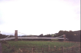
From the centre of Melrose head down the B6361 past Melrose Cathedral towards the river. At a ninety degree right-hand bend in the road take a minor road that leads off to the left. Follow this road to a suspension bridge that crosses over to the northern bank of the River Tweed.
Cross the bridge and take the minor road that heads north into Gattonside. The Southern Upland Way heads left here, but I walked right along the B6360 before taking the first left along a minor road that heads steeply uphill. After a short distance a triangular junction is reached, and turn left to contour along the hillside to the west past Gattonside Mains farm.
Shortly after Gattonside Mains Farm a T road leads off uphill to the right, and this is where the Southern Upland Way is rejoined. Head up this road as it becomes a track, and finally a footpath leading across fields past Easter Housebyres until it meets a wood. At the wood turn left and skirt it's edge. When the wood ends continue on until you meet a track. Follow the track to the north until a minor road is reached.
Continue across the road and head north past the wood on Kedslie Hill. Pass the farm at Bluecairn and head uphill to meet another minor road. Cross this road and join another road that leads to Fordswell Farm.
Just past Fordswell Farm a track leads off to the left across a field, skirting a Trig point at 274 metres. This track leads downhill and skirts to the left of some woodland before heading uphill again for about two kilometres. Shortly after you meet some woodland on the right another minor road is crossed at Woodheads Hill.
Cross the road and head slightly down the valley of Lauder Burn. The path then rises to the top of the valley, and then heads north-eastwards following the course of the burn past a golf course before descending to a road. Turn left down this road for a short distance to reach the A68(T) in Lauder.
Turn left along the A68(T) and follow it through Lauder. This small town has several pubs and shops, so is an ideal place for picking up provisions. Shortly after the B6362 road leads off to the left a minor road leads off to an industrial estate. The road curves round and, shortly past a fire station, the old railway trackbed which used to lead northwards from Lauder can be reached.
The book by Erl B. Wilkes which describes this route states that the old railway can be followed for the entire five miles to Oxton. Unfortunately I found the going very hard in places, with crops over the trackbed, so it might well be a seasonal route. The initial section of the route north of the industrial estate was very muddy with farm waste, and later on sections were either overgrown or stony. Eventually by the time I got to the point where the track that leads from the fort at Blackchester on the hillside to the left and Blackburn Farm to the right the trackbed was covered with crops, so I decided that the best policy was to head off to the right through the grounds of Blackburn Farm and join the A68(T).
Turn left along the A68(T) and follow it northwards for about two miles along the valley of Leader Water. Just before you reach the junction with the A697 an old road descends to the valley floor and meets the A697. The old road then crosses the A697 and the Carfraemill Hotel. The B&B that I stayed at is just up the road from the hotel on the left.
Distances
| From | To | Distance (m) | Ascent (ft) | Descent (ft) |
|---|---|---|---|---|
| Melrose YHA | 274 metre Trig | 7.1 | 948 | 394 |
| 274 metre Trig | Lauder | 3.1 | 302 | 600 |
| Lauder | Carfraemill | 4.5 | 279 | 187 |
This makes a total distance of 14.7 miles, with 1529 feet of ascent and 1181 feet of descent.
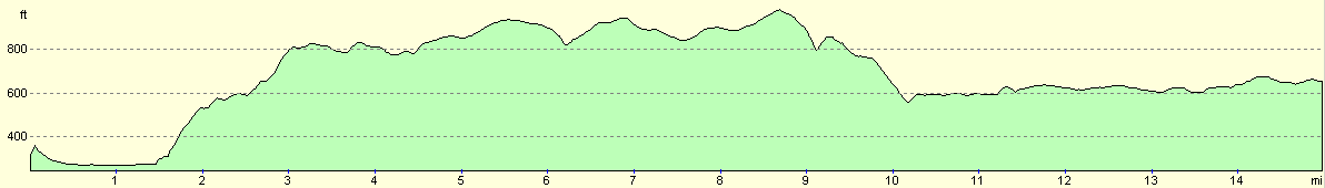
For more information on profiles, ascents and descents, see this page
Accommodation
I stayed at a very nice B&B just up the road from the Carfraemill Hotel. There is a campsite right outside the B&B as well, but the B&B was very nice and served some absolutely marvellous meals. The landlady was a bit dour at first, nut I ended up having some really lovely and interesting conversations with her. The landlady of the B&B was a Mrs Harrison, and I believe that the phone number of the B&B was (01578) 750643.
Disclaimer
Please note that I take no responsibility for anything that may happen when following these directions. If you intend to follow this route, then please use the relevant maps and check the route out before you go out. As always when walking, use common sense and you should be fine.
If you find any information on any of these routes that is inaccurate, or you wish to add anything, then please email me.
All images on this site are © of the author. Any reproduction, retransmissions, or republication of all or part of any document found on this site is expressly prohibited, unless the author has explicitly granted its prior written consent to so reproduce, retransmit, or republish the material. All other rights reserved.
Although this site includes links providing convenient direct access to other Internet sites, I do not endorse, approve, certify or make warranties or representations as to the accuracy of the information on these sites.
And finally, enjoy your walking!
This walk was mentioned in the following routes:
| My sectional Land's End to John O'Groats walk |
Nearby walks
| # | Title | Walk length (miles) |
|---|---|---|
| 111 | Ancrum to Melrose | 13.8 |
|
|

|