Walk #147: Crieff to the Head of Loch Lednock
 |
 |
|
General Data
| Date Walked | 18/08/2001 |
| County | Tayside |
| Start Location | Crieff |
| End Location | Head of Loch Lednock |
| Start time | 08.30 |
| End time | 15.26 |
| Distance | 15.4 miles |
| Description | This was a nice walk to position myself ready for getting to the highlands. |
| Pack | Today I carried full Pennine Way-specification kit. |
| Condition | When I reached camp my feet were aching, which is to be expected considering the distance that I have done today on tarmac. I have no blisters and my legs, shoulders and back are fine. All in all I feel okay considering the distance that I have come and the weight of my pack. |
| Weather | The weather today started off sunny with some scattered sparse and light cloud. By midday it was quite hot but the clouds started to gather as I slowly gained altitude. There were still some glimpses of the sun as I set up my tent, but at 18.00 it started to rain. There was a slight breeze all day which helped me keep cool. |
| OS map | Landranger number 51 (Loch Tay & Glen Dochart), Landranger number 52 (Pitlochry to Crieff) and Landranger number 58 (Perth to Alloa, Auchterarder) |
 |
 |
|
Map of the walk
Maps courtesy of Google Maps. Route for indicative purposes only, and may have been plotted after the walk. Please let me have comments on what you think of this new format. For a detailed table of timings for this walk, please see the table file.
Notes
This was a long day with which to start my campaign. It started badly at the B&B in Crieff when I realised that I had lost the bite valve off my Platypus hydration system; it had probably come off on the train or on the bus on the journey up to Scotland. I considered going into Crieff to buy another but rejected the idea because I did not think that there was much chance of getting one.
The initial part of the walk to Comrie was an uneventful one except for when a man in a car stopped and asked me if I wanted a lift, which I politely declined. When I got to Comrie I posted the two maps that I had needed for this section of the walk back home, and bought a 1.5 litre bottle of water. I then spent forty minutes on a bench opposite the post office in Comrie chatting to a biker and a lady and gentleman who turned out to be 95 and 92 years old respectively, yet still were very agile. They were a very nice couple, and they both told me tales of the hills that were fascinating.
The walk up Glen Lednock was okay, with very few steep bits to trouble me. I often stopped to chat to people - many seemed impressed when they heard about the walk that I am doing. Whist this may sound like a big-headed statement, it is actually something that I am incredibly proud of - to have got this far would have been beyond me wildest dreams back in early 1998, and therefore my sense of achievement is immense.
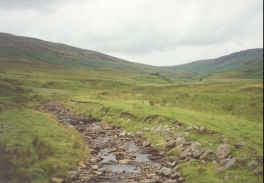
The climb from Invergeldie up to Loch Lednock was fairly gradual with some great views available along the Glen and up towards Ben Chonzie. There were a few cars parked at the end of the road up the glen, and just before the end of the road at the bridge over the River Lednock there was a family building a fire. They invited me down for a coffee but I declined as I wanted to get on, but their kindness warmed me.
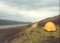
On the surfaced track that ran along the side of Loch Lednock I met four teenagers who were doing their Duke of Edinburgh Silver award expedition. They were on their last day of three and were all very tired, and one of the lads was complaining of having a very large blister. After I left them I decided to have a rest at a pipeline marked on the map at the head of Loch Lednock. When I reached the spot I found there was a handy-sized flat area of land and since I was tired and did not fancy doing the 150-metre climb to where I had been hoping to camp in the pass between Ruadh Mheall and Mealll Daimh I decided to camp early. There were some lovely views from this campsite to the southeast along the Loch, which was another factor in making up my mind to camp there.
Setting up camp early means that I will have walked about sixteen miles today, and this means that I have got about nine miles to go to get to Killin tomorrow. It also means that I could easily walk past Killin tomorrow and thus shorten the next day's walk, but I quite fancy using this opportunity to get a shower whilst I can, and therefore the YHA in Killin would be very handy.
This campsite is okay, but it is a bit noisy as the building at the end of the pipeline which I am camping next to is making a roaring sound, which I guess is water running inside the pipeline. Fortunately the sound of the rain falling onto the tent canvas is drowning out the noise from the pipeline. Beside the pipeline is the remains of an old concrete building, and I wonder what it was. It has been almost totally demolished apart from a few feet, and the rubbles has been spread evenly. I spent some time before I cooked my meal exploring this area, and I still came no closer to any answers.
When I had finished putting my tent up I went inside it for a little while to listen to the football results. I then went up the track for a little distance to fill up a spare water bottle with water from a stream. Amazingly right by the first stream was a better place to have camped, which is fairly typical.
Whilst I was cooking at 18.00 it started to spit with rain and soon afterwards this became a steady rain. If it is still raining in the morning then I may not set off until later in the day since I only have nine miles to do - it is better to delay a start and be dry than to walk unnecessarily in the wet.
Directions
This walk starts off in the center of Crieff, by the cross. Head westwards down the A85 until it reaches a junction with the A822. Turn left down the A822 and follow it for about a kilometre as it descends down a hill and to the bridge over the River Earn. Cross the bridge to the southern side of the river where the A822 road takes a sharp turn to the left. At the bend a road leaves to the right beside a campsite. Take this road and follow it for about six miles as it heads westwards on the southern side of the River Earn to the outskirts of Comrie. Although this section of the walk is on a public road, it was fairly quiet and was fairly picturesque.
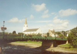
A road junction is reached on the outskirts of Comrie with a road that leads off to the north-northwest with houses on the left. Follow this road for about 750 metres until it ends round to the left past the fire station and meets the B827. Turn right down the B827 and crossover the River Earn by a very attractive bridge and meet the junction with the A85.
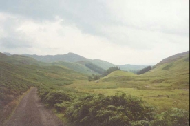
Turn left down the A95 and follow it as it almost immediately turns sharply to the right to head northwestwards. As it bends to the left continue straight on along a minor road. Head up the hill following this road as it goes past Twenty Shilling Wood before turning to meet the River Lednock near the Devil's Caldron Waterfall. The road then passes the farm at Kingarth before climbing slightly and descending to a bridge over the river. The road continues northwestwards past the farms at Funtulich and Ballindalloch until you reach a car park at Invergeldie.
At the car park the road turns to the left to take a more westerly heading. About a kilometre further on a junction is the road is reached; do not take the one that heads straight on uphill but the one that descends downhill for a short distance to a bridge over the River Lednock, followed closely by a gate across the road. Continue along this surfaced track as it starts to climb uphill beside the Allt Mathaig.
About two and a half kilometres from the bridge a junction is reached in the tracks at NN 709 288; take the track that heads uphill sharply to the right to the east of Creag nan Eun. The track, which is still surfaced, reaches a summit from where some lovely views can be seen to the north of Loch Lednock, before descending down for a short distance towards the side of the Loch. Continue alongside the track as it follows the southern side of the Loch. Near the head of the loch a junction is reached, with the surfaced track heading downhill to a building at the bottom of a pipeline, and a rough track heading uphill to the left. Take the track to the left and go uphill to a short distance until a building is reached by a hairpin in the track at NN 6953 3024. There is a level area between the hairpin in the track and the building where I put up my tent.
This walk is based on one that can be found in the book 'The Famous Highland Drove Walk', by Irvine Butterfield, ISBN 0 9515996 5 8, and published by Grey Stone Books. It is almost identical to the one described in pages 99 to 108, except the book describes a route that goes to the north side of Loch Lednock, whilst I took an easier route along the track to the south.
Distances
| From | To | Distance (m) | Ascent (ft) | Descent (ft) |
|---|---|---|---|---|
| Crieff | Comrie | 6.6 | 436 | 482 |
| Comrie | Invergeldie | 4.5 | 922 | 407 |
| Invergeldie | Head of Loch Lednock | 4.3 | 958 | 479 |
This makes a total distance of 15.4 miles, with 2316 feet of ascent and 1368 feet of descent.
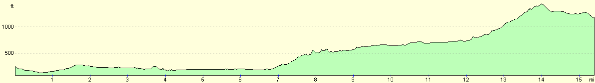
For more information on profiles, ascents and descents, see this page
Accommodation
I spent the night in a lovely tent near a pipeline at the head of Loch Lednock.
Disclaimer
Please note that I take no responsibility for anything that may happen when following these directions. If you intend to follow this route, then please use the relevant maps and check the route out before you go out. As always when walking, use common sense and you should be fine.
If you find any information on any of these routes that is inaccurate, or you wish to add anything, then please email me.
All images on this site are © of the author. Any reproduction, retransmissions, or republication of all or part of any document found on this site is expressly prohibited, unless the author has explicitly granted its prior written consent to so reproduce, retransmit, or republish the material. All other rights reserved.
Although this site includes links providing convenient direct access to other Internet sites, I do not endorse, approve, certify or make warranties or representations as to the accuracy of the information on these sites.
And finally, enjoy your walking!
This walk was mentioned in the following routes:
| My sectional Land's End to John O'Groats walk |
Nearby walks
| # | Title | Walk length (miles) |
|---|---|---|
| 118 | Auchterarder to Crieff | 9.7 |
|
|

|