Walk #221: Acle Station to Norwich via Wroxham
 |
 |
|
General Data
| Date Walked | 18/09/2002 |
| County | Norfolk |
| Start Location | Acle Station |
| End Location | Norwich Station |
| Start time | 08.45 |
| End time | 16.52 |
| Distance | 21.2 miles |
| Description | This walk was a combination of two walks that I had planned; each was about ten miles long so it made sense to combine them into one rather than do them as two short, separate ones. The majority of the walk was long roads which was a shame, but this was more than made up for by the lovely churches that I was able to visit en route. |
| Pack | Today I carried my 30-litre Karrimor Hotrock rucksack, which contained a fleece and waterproof coat. It also contained the usual assortment of odds and ends including a book and two litres of water in it, carried in a 2-litre Platypus container. |
| Condition | I feel fine after this walk. I have no major problems; no blisters and no aches. I am slightly fatigued, but apart form this I am okay, which is a good sign for the forthcoming long walk. |
| Weather | The weather today was mainly cloudy, with some heavy grey clouds overhead. These occasionally broke and were replaced with a few short sunny periods that were welcome. A mild wind helped keep me cool when the sun was out, and fortunately it was not accompanied by any rain, aside from a slight shower just as I was going in for my lunch break. |
| OS map | Landranger number 134 (Norwich & The Broads, Great Yarmouth) |
 |
 |
|
 |
 |
|
Map of the walk
Maps courtesy of Google Maps. Route for indicative purposes only, and may have been plotted after the walk. Please let me have comments on what you think of this new format. For a detailed table of timings for this walk, please see the table file.
 |
Notes
The main aim of this walk was to close the gap in my previous walks which existed between Norwich and Wroxham, which I wanted to complete before I set off on my big walk in a couple of weeks time. This walk was only going to be about ten miles long, and although I could have extended it by making the route between the two towns less direct I decided to extend the walk by combining it with another walk that I had on my list of planned walks, that being the walk from Wroxham to Acle.
The highlight of today was definitely the churches, which were all very nice and, unusually, most of them were open so that I could have a cursory look around inside them. I am starting to get very interested in church architecture, and therefore
All the villages that I passed today were quite nice, and Woodbastwick and Ranworth were little pearls. Many people do not like road walking and prefer to stick to walking along footpaths or in the hills, but sometimes road walking gives you pleasures that are not available on either of those. Footpaths - particularly long distance ones - tend to avoid small villages, whilst roads tend to cling to them. If I had tried to do these walks whilst keeping to footpaths I would have had a much longer walk and would not have visited these lovely villages.
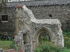
South Walsham is fairly unusual for a village of its size because it had two medieval churches in the same churchyard. The first I saw was the remains of St Lawrence Church, which only has the nave remaining. The remains of the rest of the church are now a garden, which fits inside the tumbledown walls of the rest of the church. Beside St Lawrence church is St Mary's Church, which dates mainly from the mid-fourteenth century and is still fully extant.
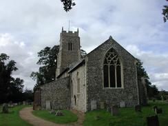
Ranworth church was very nice, the best bit for me being the elaborate detailed painted screen separating the nave from the chancel. The church also has a visitor's centre and coffee shop in a converted coach house on the grounds. You can also arrange to go up the tower to admire what are apparently spectacular views of the surrounding area, but I decided not to do this, as I wanted to press on with the walk. The screen in this church was an absolute gem - it is painted and portrays the apostles and popular saints of the 15th century. There is also a late 15th century Antiphoner, or illuminated service book, which was given to the church by a Wiliam Cobbe. The book was absolutely superb, but it was hard to get a good photograph of it as it is behind glass and reflections spoiled the shots.
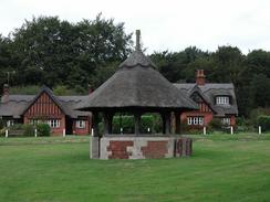
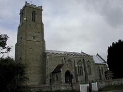
St Fabian and St Sebastian Church, Woodbastwick was very nice, with a 13th century rood screen, which was similar in design to that of Ranworth Church, but with the rood still in place. The screen is unpainted unlike that of Ranworth Church, but is a nice example nonetheless. The church was also the first that I recall seeing which was thatched; not in straw which is usual in most of the country but in reeds, which were historically much more available in the immediate area. The church tower also has a new clock face that was donated to the church to commemorate the millennium. The village green, which is immediately adjacent to the church, has a thatched pump house on it, which still has a hand-powered pump in it. Behind the pump house are some Alms houses that were also thatched, and the buildings made the centre of the village very nice indeed.
On the way west from Woodbastwick I passed the Woodfordes brewery, which is a brewery that makes some fairly nice beers that I have been known to drink in the past. I nipped into the shop to have a look around, but I did not fancy having to carry beer for the rest of the walk so I did not buy anything. There is a pub attached to the brewery that was about to open, but I still had a fairly long way to walk and I decided to have a drink so early might be more of a hindrance than a help.
The church of St Mary the Virgin in Wroxham was quite nice, with a lovely painted and engraved doorway within the porch leading into the interior of the church. The interior was dominated by a modern western screen which I must admit I did not really like as the wood was light coloured and did not look as though it fitted in with the rest of the church in my eyes. I stopped off for a rest at the Kings Head Hotel in Wroxham, which is right in the centre of the town. I had a pint of Directors beer and a packet of quavers whilst I measured the map to see exactly how far I had come and how far I had to go. Satisfied that I was doing well and that I had enough time to finish the walk, I set off once more.
The area around the cathedral in Norwich was very pretty, with the tall spire of the Cathedral dominating the views. The building that intrigued me most, however, was the low arch at the end of Ferry Lane beside the river. This archway was named Pool's Ferry after John Paul, who was a ferryman. It was built in the reign of Elizabeth 1st. Originally it had been named Sandlings Ferry after the first ferryman, but was renamed later. The Watergate itself is medieval.
Directions
This walk starts off in the car park at Acle Station, which is on the Norwich to Great Yarmouth railway line. Leave the car park by means of a tarmac footpath that leads down between the A47(T) to the left and the railway line to the right. When this path ends after a short distance at a road, turn left and follow the road as it immediately passes under the A47(T).
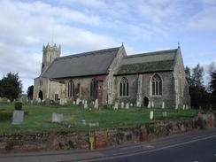
At a T-junction continue straight on along the road until the Parish Church of St Edmund, Acle is reached on the left. From the church continue straight on until a complex junction is reached in the centre of the town. Pass Mill Lane on the left and take the road a short road that leads off to the northwest, signposted for Upton and South Walsham.
When this road ends at a T-junction turn left down South Walsham Road and follow the road out of the village, passing Acle High School on the way. The road continues on, passing the Mannings Hotel on the right, shortly after which the road becomes Acle Road. Follow the road for another couple of miles as it winds around until it reaches the church in South Walsham.
Leave the church and follow the road as it passes to the right of the Ship pub. Take the first road to the right, which leaves the village on northwesterly heading and descends to cross over South Walsham Broad. On the other side it climb uphill once more and passes a series of brick houses with thatched roofs, which are quite unusual. The road descends downhill to meet the edge of Ranworth Broad at a car park beside the Maltsters pub.
From the car park a boardwalk leads off westwards beside the road. Follow this boardwalk until it dumps you unceremoniously on the road at a junction. Continue straight on and after a few yards a tarmac path starts on the left, running immediately beside the road. This path ends right beside Ranworth Church.
From the church continue onwards for a couple of miles westwards towards Woodbastwick, crossing Cockshoot Broad on the way. Once Woodbastwick church is reached continue on past the village green and pump house and leave the small village. The road passes an old forge before getting to the Woodforde's brewery, which has an adjacent pub.
Continue on along the road until you reach a road junction in Salhouse. At this junction turn right along a road that is signposted for light traffic only. Continue on along this minor road for about a kilometre until you reach Vicarage Farm. Just beyond the farm turn right along a track that is not marked as a footpath on the map but has a Norfolk county council circular walk way marker, so I assume that it is a public right of way. The track starts off as a nice green lane with hedges on both sides, but the hedge on the right soon ends and the track becomes a path across a field with a hedge to the left. On the far side of the field the hedge on the right restarted and the path became a green lane once more before ending at a tarmac lane beside Hospital Farm.
Continue straight on along the lane until it ends at a T-junction with the B1140 Salhouse Road. Turn right and follow the road as it heads northwards for a mile into Wroxham. On the outskirts of the town it turns sharply to the left and continues onwards for about thirty yards before ending at a roundabout with the A1151 road. If you do not wish to enter Wroxham and want to continue on to Norwich then skip the next few paragraphs; the route I took comes back to this roundabout later.
Turn right along the A1151 road and follow it northwards for a short distance until the first road on the left, Castle Street, is met. Turn left down Castle Street and follow it as it passes over a railway line. On the other side of the bridge turn right down Church Lane. This heads northwards for a short distance before curving sharply to the right to climb over the railway line once more. The Church of St Mary the Virgin, Wroxham, is just to the left at this bend.
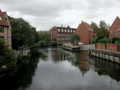
Follow the road as it climbs over the railway line and shortly ends at a T-junction with the A1151 road. Turn left down the A1151 road and follow it as it curves around to the bridge over the River Bure. Cross over the bridge using the pedestrian bridge on the right of the road bridge and take the first road to the left. This is Station Road and passes the Kings Head Hotel and a short-stay car park before ending at a T-junction, at which the station is immediately to the left.
From the station head back down Station Road to meet the A1151 road in the centre of Wroxham. Turn right down the A1151 and follow it as it goes over the bridge over the River Bure and heads southwards for a little over a kilometre to the roundabout with the B1140 road that was visited earlier.
From the roundabout continue on southwards along the A1151. This road rises up to a bridge over the railway line; this road was fairly busy and great care had to be taken on the blind bends leading to and from the bridge. Continue on down off the bridge and then take the first track to the right, which is surfaced. Follow the track westwards until it bends sharply to the right beside an attractive brick and wood cottage. As the track bends continue straight on along a wide dirt track that veers slightly to the left.
This track has a very good dirt surface and good progress can be made until it ends at a bend in a tarmac road called Dobbs Lane. Turn right along this road and follow it westwards for a mile as it becomes Rackhheath Lane and until it reaches the B1150 on the eastern outskirts of Spixworth. Carefully cross the B1150 and continue straight on along Crostwick Lane which heads through the village before ending at a T-junction with Buxton Road on the western outskirts of the village beside the Longe Arms.
Turn to the left and follow Buxton Road as it heads southwards out of the village. As it leaves the village the pavement becomes a wide cycle path that can be followed all the way into Norwich. Cross over the junction with Beeston Lane and continue on into the northern outskirts of Norwich. Cross over White Woman Lane and follow the road as it becomes Spixworth Road. Continue on southwards, passing the junction with Church Lane on the right, and passing the new-looking war memorial.
When the road meets the A1042 continue straight on across the road which heads downhill down St Clement's Hill before ending at a T-junction with the B1150 road. Turn right down the B1150 and follow it for a short distance until it too ends at a T-junction with the A1151 road. Turn right and follow the A1151 road for a short distance until it curves sharply to the left.
At the bend continue straight on down Magdalen Street. This passes under a large bridge that carries part of the dual carriageway overhead. Pass the St Clement Colegate Church on the right before crossing a bridge over the River Wensum. Pass another church before the road ends at a roundabout. Turn right and immediately cross over the road using a pedestrian crossing that leads to the statue of Edith Cavell. Beside the statue is a large stone gateway that leads into the grounds of Norwich Cathedral. Go through the gate and follow the road as it heads straight to the western door of the cathedral.
At the western door turn right along another road which skirts some ruins until it ends at a T-junction, with another gateway about fifty yards away to the right. Turn left down this road, which is called Ferry Lane, and follow it downhill to a large gatehouse beside the river. At the gatehouse turn right through a gate along the riverside walk. This soon through another gate and runs alongside the river until it ends at a pub beside a bridge. Use the stairway provided to climb up onto the first-floor terrace of the pub and then leave the pub onto the northern approach of the bridge. Cross the bridge and use the pedestrian crossing on the other side to cross the road. Norwich Station is on the left across another road.
Distances
| From | To | Distance (m) | Ascent (ft) | Descent (ft) |
|---|---|---|---|---|
| Acle Station | Ranworth Church | 4.9 | 213 | 200 |
| Ranworth Church | Wroxham Station | 6.4 | 187 | 203 |
| Wroxham Station | Spixworth | 5.1 | 164 | 115 |
| Spixworth | Norwich Station | 4.8 | 148 | 200 |
This makes a total distance of 21.2 miles, with 712 feet of ascent and 718 feet of descent.
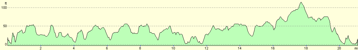
For more information on profiles, ascents and descents, see this page
Transport
There are regular train services running from Norwich Station to Acle Station, which take about 25 minutes. The cost of a single ticket is £2.90. There are also regular train services from Wroxham and Hoveton Station to Norwich Station if you want to split this walk into two separate walks.
Disclaimer
Please note that I take no responsibility for anything that may happen when following these directions. If you intend to follow this route, then please use the relevant maps and check the route out before you go out. As always when walking, use common sense and you should be fine.
If you find any information on any of these routes that is inaccurate, or you wish to add anything, then please email me.
All images on this site are © of the author. Any reproduction, retransmissions, or republication of all or part of any document found on this site is expressly prohibited, unless the author has explicitly granted its prior written consent to so reproduce, retransmit, or republish the material. All other rights reserved.
Although this site includes links providing convenient direct access to other Internet sites, I do not endorse, approve, certify or make warranties or representations as to the accuracy of the information on these sites.
And finally, enjoy your walking!
Nearby walks
| # | Title | Walk length (miles) |
|---|---|---|
| 211 | Attleborough to Norwich | 17.0 |
| 215 | Wroxham to North Walsham via Aylsham | 16.2 |
| 720 | Diss to Norwich | 24.2 |
|
|

|