Walk #215: Wroxham to North Walsham via Aylsham
 |
 |
|
General Data
| Date Walked | 25/08/2002 |
| County | Norfolk |
| Start Location | Wroxham Station |
| End Location | North Walsham Station |
| Start time | 08.53 |
| End time | 14.13 |
| Distance | 16.2 miles |
| Description | This was a highly enjoyable walk, initially following the Bure Valley Way beside the narrow-gauge railway, and latterly along the Weavers' Way, this section of which is another old railway line. |
| Pack | Today I carried my 30-litre Karrimor Hotrock rucksack, which contained a fleece, waterproof coat, trousers and a pair of trainers in it. It also contained the usual assortment of odds and ends. It also had two litres of water in it, carried in a 2-litre Platypus container. |
| Condition | I feel generally okay after this walk. My legs are slightly stiff, but this is to be expected considering I did not have a stop during the walk. I have a slight hotspot on the heel of my right foot, but have no blisters on my toes. This is very good considering this was the first time that I had worn my Scarpa boots. |
| Weather | As the day went on the initial sunshine faded and was replaced with some dark, ominous clouds forming overhead. There were a couple of short periods of rain, one of which promised to be quite heavy, but these only lasted for a couple of minutes. The wind built up later on in the day, and at one stage I felt cold enough that I considered putting my fleece on. |
| OS map | Landranger number 133 (North East Norfolk, Cromer & Wroxham) |
 |
 |
|
 |
 |
|
Map of the walk
Maps courtesy of Google Maps. Route for indicative purposes only, and may have been plotted after the walk. Please let me have comments on what you think of this new format. For a detailed table of timings for this walk, please see the table file.
 |
Notes
On previous walks I had left a gap between Norwich and North Walsham that needed to be walked. Whilst this distance was small enough that it could be done in a day, there are two old railway paths from Wroxham to Aylsham and Aylsham to North Walsham that were crying out to be walked. This meant that walking the extra distance from Wroxham to Norwich as well would be too much for a day, and so I decided to split the walk into two separate days.
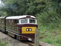
The Bure Valley railway is a 15" narrow gauge railway that was constructed in about 1990 It follows the course of an old Great Eastern Railway line which opened in 1880 and closed to passengers in 1952, although freight traffic did not cease for another thirty years. As I walked along the Bure Valley Way I caw a few trains come past me at speed, and despite the fact that it is a narrow gauge railway the locos seemed to be gong quite fast, although that may just be a feature of the fact that they are quite small.
I forgot a thicker pair of socks and was only wearing my 1000-mile socks, so I was expecting to get blisters on my feet, especially as I was trying out my new Scarpa boots for the first time. After about three miles my feet were okay with no signs of any hotspots developing, but my right ankle was giving me periodical moments of pain when I thrust off on the right foot, which luckily vanished after a couple more miles.
Later on in the day I realised that I may just be able to catch the 14.24 service from North Walsham, which would prevent me from having to wait for two hours for the 16.24 service. Having decided I was gong to catch that train I started to walk quite fast and decided not to have any rest stops. Fortunately this policy worked, and I managed to get to North Walsham Station eleven minutes before the train was due.
The Bure Valley Railway terminus at Aylsham was quite nice, with a train shed over the tracks, a turntable and a water tower dominating the view. The station building seemed to be fairly new, but looked quite traditional and nice. In the car park there is a business hiring out cycles to people wanting to ride along the trail.
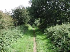
The second half of the walk was along the Weavers' Way, which runs for about sixty miles from Cromer to Great Yarmouth. The section that I walked along followed the course of the old Melton Constable to North Walsham railway line, which was part of the Midland and Great Northern railway and was opened in 1883 and closed in 1959. This section of walk was fairly scenic and was more enjoyable than the first part of the walk along the Bure Valley Way.
Felmingham Cutting on the Weavers' Way is a Butterfly Nature Reserve, which has become populated with a wide variety of butterflies since the line closed, sixteen different species having been found here. The whole cutting is managed to keep a series of different breeding areas for different species, and is very scenic.
Yesterday I went out and bought myself a new pair of cross-trainers and a new pair of boots. I decided that this walk would be a good time to try out my new boots, and because I was expecting that they may cause me problems I took my existing trainers in my rucksack just in case I needed them.
I now only have a short walk to do to complete the entire walk from Ely to Cromer via Norwich, that being the section from Norwich northwards to Wroxham. I shall hopefully do this walk soon, and because it is so short I will probably extend it. The only problem with extending it is that the River Bure (which runs from west to east) cannot be crossed without a ferry downstream of Wroxham, and so any extensions may well have to be fairly convoluted to get around this problem.
Directions
This walk start off at the long-stay car park, which is adjacent to the Wroxham and Hoveton railway station and the Bure Valley Railway. Leave the car park towards the underpass under the railway station but before the underpass is reached turn left up a ramp beside the station platform. This ramp leads up to a footbridge over a road before descending down towards the railway signal box and Bure Valley Railway station. Pass to the left of the station building and turn right to join a cycle- and footpath that follows the course of the Bure Valley Railway. The Bure Valley Way is only a concessionary path, and the public are allowed to use it at their own risk.
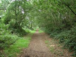
The path consisted of firm gravel or grass underfoot and made for fairly good going, the presence of the adjacent railway meaning that the path was kept clear and was not overgrown. Initially the path climbs up slightly, leaving both the Bure Valley and the main line railways in a cutting to the right, before descending as the narrow gauge railway turns to the left to leave the main line. The path then joins the narrow gauge line and continues on at the same level.
The railway and path cross a road at a level crossing before curving to the left to pass uder a road bridge, after which they enter a shallow cutting. It then passes over a narrow single-track road before progressing on to pass under another road, the bridge for which has quite a nice triple arch, the outermost arches being firmly embedded in the side of the cutting. The path and track then curve around to the right before passing under another bridge, which again is a three arch structure. About a hundred yards further on it passes under another bridge that carries the B1150 overhead and has a green pedestrian footbridge beside it. On the other side of the bridge the platform for Coltishall Station is reached.
The path continues on, passing under another bridge which this time has brick abutments and a metal deck overhead as it curves to the right and then passes over a road which leads to Grove Farm to the right. On this stretch of line the path passes immediately to the left of RAF Coltishall, the radar for which can be seen to the right, with landing lights on either side of the path. This RAF base was built at the start of World War II, and during the war Coltishall served first as the home of 242 Squadron RAF, commanded by famous pilot, Squadron Leader Douglas Bader, and later of a division of the United States Army Air Force. The path then continues under another bridge with a metal deck, the abutments of this one being made of blue engineering brick for a change. This bridge leads off to Little Hoitbois on the right.
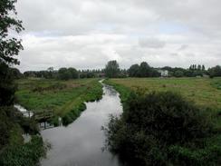
At a level crossing over a single-track concrete road which leads to a farm to the left cross over to the other, right-hand side, of the railway line and continues on to the northwest. The path emerges onto a long straight stretch of embankment and passes a passing loop on the railway, with the River Bure being visible on the left. A bridge that carries the path and railway over the River Bure is then reached, before crossing over another road and reaching Buxton Station.
The path continues on to the northwest, passing over a bridge and a passing loop on the railway that is followed by another under bridge before Brampton Station is reached. The path continues on, still on the right-hand side of the bridge, and passes under two bridges before passing over the small The Mermaid stream. It then passes over a level crossing and under another bridge before rising up to meet the A140 road, whilst the railway line continues on through a tunnel underneath the road. Carefully cross the A140 road and pass through a gate to continue along the grass path on the other side as it slowly descends to meet the railway once more on the other side. It then passes between some houses on the right and the railway on the left before getting to the car park of the Aylsham terminus of the Bure Valley Railway.
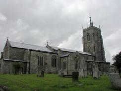
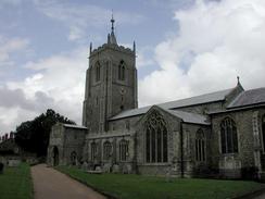
Leave the car park by following Station Road past the station building up to meet the B1354 Norwich Road. Turn right sown this road into the city centre, passing a Budgens superstore on the way. When this road turns sharply to the left continue straight on down Red Lion Street and follow it as it turns to the left and then the right and becomes Cromer Road. On the right-hand bend a path leads up to the lych gate that leads into the churchyard of St Michael and All Saints Church, Aylsham.
Continue up Cromer Road and continue past the sixty-mile an hour signs. Shortly after the signs the road starts to climb up to go over a bridge over an old railway line. Before the road starts to rise go through a gate to the right and enter a field. Turn left along the hedge bordering the road until a stile that leads onto the old railway line is reached. Later on by reading the guide book I have at home I realised that the path acutally turns to the left as the road rises up to meet the bridge and then passes under the bridge.
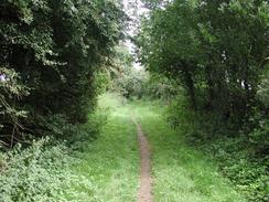
Turn right along the old railway line and follow it as it passes over a couple of bridge that lead to the bridge over the River Bure. The path is less clear than the previous one alongside the Bure Valley Railway but the going was not bad nonetheless. On the other side of the river bridge the path ends at a car park, to the left of which is a road. Turn right along this road for a short distance until it ends at a T-junction with Banningham Road. Turn left down Banningham Road following the Weavers' Way signs. A short distance further on turn right down a road which is guarded by dead-end signs. This is not part of the Weavers' Way, but is a slightly shorter route that I decided to take.
At the end of the road there is a barn beside a field. A footpath leads off along the side of the field beside the barn, with a hedge on the right. At the end of this field there is a stile in the hedge ahead beside the hedge on the right; this was very overgrown so I went through a gap in the hedge about twenty yards away to the left. The path continues on across another field; in reality it angles away slightly to the left but the way was indistinct so I chose to follow the right-hand edge of the field, with the hedge and a road beyond it on the right rather than trample across the crops.
When the fields end at a hedge beside the A140 road turn left and walk for a hundred yards to a gate to the right. Go through this gate onto the A140. Turn left and walk along the A140 along a wide verge for fifty yards until a track way to the left and right on either side of the road is reached. Carefully cross the busy A140 and follow the track to the right, which is signposted with a Weavers' Way sign.
The path follows a green lane between two fields that wind slightly, but heads in a roughly easterly direction. The track soon ends at a larger, concrete track that runs from north to south. Turn right to walk south along this track past a house until it ends at the old railway line at the site of the old Green Lane Level Crossing. Turn left to follow the old line eastwards.
The path goes into a cutting, which ends before an over bridge is reached, before it continues on along a low embankment through the trees. The path then passes over a bridge over Blackwater Beck before crossing a road on the level and continues along a short embankment before entering Felmingham Cutting. On the eastern side of the cutting the path passes the site of the old Felmingham Station, which had a complete but very overgrown platform, before passing over a road.
Almost immediately after this bridge the path passes over another minor road on a high bridge before entering North Walsham Wood in a cutting, which was a nice, scenic stretch, with conifers to the right and a delicious pine smell in the air. At the end of the woodland the path passes over another minor road by means of a bridge and starts to curve in a more north-easterly direction.
The path passes to the left of a lorry park before crossing a road on the level. Cross the road and continue on along the path on the other side, heading towards North Walsham. Houses start to encroach on either side of the path, and it becomes bordered by hedges. When a small and dark area of woodland is reached with a bench in the middle the path ends at a road. Cross over this road and continue along with houses on the right and a road on the left, although the path itself is a nice green corridor without many views of either.
When the path ends at a T-junction with a tarmac path turn left down the new path for about ten yards until it ends at Skeyton New Road. Turn right down this road until it ends at a T-junction. Turn right at this junction and immediately pass under a large bridge under the railway, and then under a bridge that carries the A149 high above.
On the other side of the road bridge turn right down Park Lane and follow this road until it splits at a Y-Junction. AT this junction turn right down Norwich Road, which continues for a short distance until it reaches a crossroads with the A149. Cross over the A149 using a pedestrian crossing and the station is a few yards ahead on the left hand side of the road. The platform for trains back to Wroxham and Norwich is on the near side of the station, and trains for all stations to Cromer are on the other side of the bridge.
For more details on the Weavers' Way, see "Langton's Guide to the Weavers' Way and Angles Way", by Langton's Guides, ISBN 1-899242-01-5.
Distances
| From | To | Distance (m) | Ascent (ft) | Descent (ft) |
|---|---|---|---|---|
| Wroxham Station | Aylsham Station | 9.0 | 335 | 253 |
| Aylsham Station | North Walsham Station | 7.2 | 249 | 220 |
This makes a total distance of 16.2 miles, with 584 feet of ascent and 473 feet of descent.
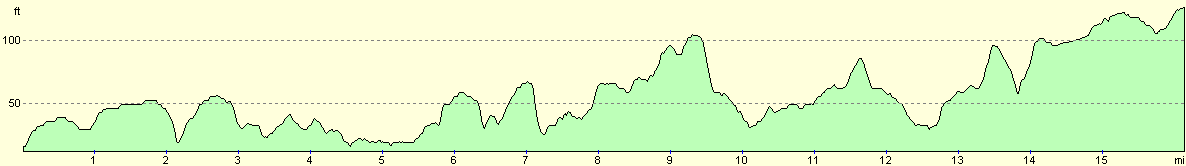
For more information on profiles, ascents and descents, see this page
Transport
There are regular railway services running between North Walsham and Wroxham and Hoveton stations. On Sundays these trains run every two hours, but are more frequent during the week. A single ticket costs two pounds. The Bure Valey railway also runs train services daily during the tourist season (between April and October) from Ayslsham to Wroxham if you wanted to do a shorter walk. They can be contacted at: Bure Valley Railway, Norwich Road, Aylsham, Norfolk NR11 6BW; tel: 01263 733858. or at their website.
Disclaimer
Please note that I take no responsibility for anything that may happen when following these directions. If you intend to follow this route, then please use the relevant maps and check the route out before you go out. As always when walking, use common sense and you should be fine.
If you find any information on any of these routes that is inaccurate, or you wish to add anything, then please email me.
All images on this site are © of the author. Any reproduction, retransmissions, or republication of all or part of any document found on this site is expressly prohibited, unless the author has explicitly granted its prior written consent to so reproduce, retransmit, or republish the material. All other rights reserved.
Although this site includes links providing convenient direct access to other Internet sites, I do not endorse, approve, certify or make warranties or representations as to the accuracy of the information on these sites.
And finally, enjoy your walking!
Nearby walks
| # | Title | Walk length (miles) |
|---|---|---|
| 163 | Sea Palling to Mundesley | 9.4 |
| 168 | Cromer to North Walsham via Mundesley | 12.8 |
| 221 | Acle Station to Norwich via Wroxham | 21.2 |
|
|

|