Walk #214: Sandy to Bedford
 |
 |
|
General Data
| Date Walked | 22/08/2002 |
| County | Bedfordshire |
| Start Location | Sandy Station |
| End Location | Bedford Bus Station |
| Start time | 09.18 |
| End time | 13.57 |
| Distance | 12.0 miles |
| Description | This was an enjoyable walk which visits some nice, interesting places en route. It also follows a cycle path for some of the distance that means that it is very quick going for the most part. |
| Pack | Today I carried my 30-litre Karrimor Hotrock rucksack, which contained a fleece, waterproof coat and trousers along with the usual assortment of odds and ends. It also had three litres of water in it, carried in 1-litre and 2-litre Platypus containers. |
| Condition | I feel fine after this walk. I had a slight hotspot on my left foot from yesterday's walk but this did not trouble me much even though I was wearing my X-Adventure 7's once more. |
| Weather | The weather today was very much like yesterday, with sunshine and cloud and not much of a breeze. It did not get too hot though, which meant that I did not overheat at all. |
| OS map | Landranger number 153 (Bedford & Huntingdon, St Neots & Biggleswade) |
 |
 |
|
 |
 |
|
Map of the walk
Maps courtesy of Google Maps. Route for indicative purposes only, and may have been plotted after the walk. Please let me have comments on what you think of this new format. For a detailed table of timings for this walk, please see the table file.
Notes
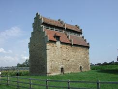
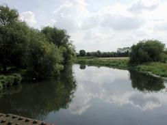
The highlight of the day was definitely the dovecote and stables at Willington, which were some quite spectacular buildings and are the only National Trust properties in Bedfordshire. These two buildings were near to the village church, which made the whole setting very nice indeed and well worth exploring. Sir John Gostwick, the Earl of Gostwick, commissioned the stables and dovecote and they were completed in around 1541, at about the time that Henry VIII visited Willington. The stone for the buildings was obtained from the dissolution of Newnham Priory. The dovecote has 1,500 nesting boxes within it and as I walked around it the sound of the birds inside it was fairly loud. A field of sunflowers, which made the whole scene quite picturesque, surrounded the dovecote and matched the colour of the stone well. A stone above the fireplace in the stables is signed 'John Bunyan', but it is not known if this is a genuine signature. The Earl of Gostwick is buried in the Church of St Lawrence in Willington, and above his tomb is hung the tabard that he wore at the field of the cloth of gold. The stables and dovecote can be opened for groups by prior arrangement, and are opened to the public occasionally. Danish Camp, which is next to the Haven, is a scheduled English Heritage ancient monument that is believed to be a harbour where the Danes kept long ships in the times of Edward the Eldar.
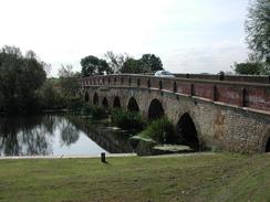
Great Barford Bridge was quite a pleasant surprise, as it is a very nice bridge. It looks very old, and is narrow and long (indeed, much of it is more of a causeway than a bridge). Underneath it are a series of narrow arches, and it is hard to believe that boats can pass through these, but one did just that as I was passing back over it.
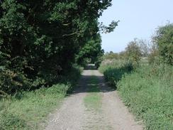
Some of the old Bedford to Sandy railway line has been converted into a cycle path which made this walk much more direct than it would otherwise have been. The sections that had been converted were very nice to walk along, with good, firm surfaces underfoot allowing fast progress to be made if necessary. This line was part of the Oxford to Cambridge railway line, and there are serious plans to reopen it as an east to west rail link across the country. Although this means that the cycle path would not be able to use the same route, the line is such an important missing link in the rail network that a diversion of the cycle path would probably be worthwhile. There are already two opposing groups campaigning about ht line; a group wanting it built and another group who do not want it built. If the cycle path extended all the way to Sandy (and there is not much stopping it from doing so then it would be much more handy; as it is it ends at a road bridge essentially in the middle of nowhere which makes it less useful as a through route.
Along the course of the old railway line there were plenty of Blackberry bushes, and since it was coming into season I would stop every so often to pick a few blackberries an eat them. This gave me a slight thirst so I stopped off at the Priory Marina, which is by the entrance to the Priory Country Park and marina so that I could have a pack of crisps and a pint of orange and lemonade.
I had decided to visit both railway stations in Bedford, as well as the bus station which I needed to get to get the bus back to Sandy. The first station I visited was St Johns Station, which I found hard to find, as it is small and hidden away at the end of a car park. This station serves the Bedford to Bletchley line, and is very much a minor station. The main station is Bedford Midland, and this was much larger and is the northern end of the Thameslink system and the northern extremity of the Midland Main Line electrification.
This walk has set me up well to do two other walks; from Bedford northwestwards to Rushden and from Bedford south-westwards towards Fenny Bentley and Milton Keynes. I am not in much of a hurry to do either of these, however, and they may never get done.
Directions
This walk starts off at Sandy Station, which is to the southeast of the town. The station has a car park which costs £2.20 to park in for a day before 10 a.m. and £1.00 after 10 a.m. during the week. Leave the station and turn right down Station Road for a short distance past the Bell pub until it ends at a T-junction with High Street. At the junction turn left and follow High Street northwestwards into the centre of Sandy. Pass the church of St Swithun, Sandy and continue on until a roundabout is met.
At the roundabout take the second exit to the right which is called St Neots Road. This heads northwestwards out of the town to a mini roundabout. At this roundabout continue straight on until the A1 is met beside the New Inn pub. Do not attempt to cross the A1 on the level but turn right to cross St Neot's Road and follow the A1 northwards for a short distance along a pavement. The A1 rises up to the left and the pavement ends at a road. Turn left down this single-track road which heads under the A1 before ending at a roundabout.
At the roundabout a track leads off straight ahead; this is the course of the old railway line from Bedford to Sandy. I believe that the next section of the walk can be shortened slightly be heading straight ahead along this track which meets up with the footpath that I took a little further on; however I did not walk this so cannot prove it one way or another. At the roundabout turn right down Georgetown and follow it past a row of houses. At the end of the houses and just before Georgetown meets the A1 a footpath leads off to the left along a narrow track. The track crosses a field and ends at a concrete track which I believe leads directly to the roundabout on Georgetown.
At the track turn right and then after a short distance when the track turns to the right continue straight on along another footpath. As soon as the footpath starts the tower of Blunham Church can be seen ahead in the distance. The track then turns to the left slightly and becomes narrower and more overgrown before crossing a tributary of the River Ivel and reaching a gate. It then crosses some fields between two wire fences, which end at a bridge over the River Ivel itself. Cross the bridge and follow the tarmac path on the other side until it meets a road. Turn right down the road for a short distance until it ends and then right down Park Lane towards St Edmund or St James Church, Blunham.
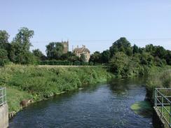
When Park Lane ends beside the church turn left up High Street that climbs uphill and heads westwards. When the junction with Station Road is met on the left the road continues on as Barford Road. Follow this road westwards for about a mile until some traffic lights are met just before the narrow Barford Bridge, which carries the road over the River Great Ouse. Carefully cross the bridge onto the other side, and continue straight on past the Anchor Inn to All Saint's Church, Great Barford, which has a nice tower that is topped by pinnacles, which are nearly as tall as the very short spire.
Leave the church and head back over Barford Bridge to the traffic lights. At the lights turn right and head south south westwards along this road. The road passes under some power lines and then climbs up to cross over the old railway line on a bridge. On the other side of the line the road curves sharply to the right as it descends to the left of the old line. Once the descent has finished a path leads right through the hedge and leads back on itself to end at the tarmac cycle path, which runs along the course of the old railway line. There was a sign at the start of the cycle path stating that the intention was to extend it under the bridge to make a better exit.
Follow the cycle path as it heads westwards. Initially there is a little lake to the right but this soon ends and is replaced by an area of floodplain. The river soon approaches the line from the right until a bridge over the river becomes visible on the right. When the bridge is reached the path turns off the old railway line to the right and heads to meet the bridge. It then turns left along the southern bank of the Great Ouse until it reaches Willington Lock. Beyond the lock the path turns to the left to leave the river and passes between two hedges and then turns to the right.
The path continues on westwards, passing a place on the right called the Haven that has a cycle hire shop and what looks like a very nice cafe. Next to the Haven is the remains of the old platform of Willington Station, which is now very overgrown and has been the first signs so far that this was an old railway line. The path continues on past an old brick railway hut until it ends at a track, where there is an information board giving information about the village of Willington. If you wish to visit the dovecote, stables and church then they are down the track to the left.
Turn right down the track and cross a little bridge over a stream and enter an area of woodland. When a gate is reached turn left off the track and follow the path through the trees. The path slowly angles back to the course of the old railway line before the trees end at a tarmac haul road, which leads of to a sand pit on the right. Cross over this track and continue straight on down a tarmac path which after a while starts to turn to the right to angle towards the A421(T) road. The path climbs up to go over the main road on a bridge, from where the two large aircraft hangars at Cardington can be seen in the distance to the left. On the other side of the bridge the path turns to the left and descends to the surrounding fields before turning right to join the old railway trackbed once more.
The path passes under an old railway bridge and continues on to cross over the Great Ouse using a bridge. On the other side of the river bridge there is a tarmac single-track road on the left and a sandy path on the right. These end at a car park, at the end of which is a road leading into the Priory Country Park and the marina. The Priory Marina pub is just up the road to the left. The path continues on across the road and after a while crosses a bridge over a tributary of the river and then over the river itself, with a road bridge to the right.
On the other side of the bridge the path ends at a T-junction with a track which leads to a large glass pyramid to the left. Turn right down the track and then immediately to the left, to walk between the road coming down off a bridge to the right and the railway embankment on the left. The embankment on the left slowly gets lower until eventually the path ends at the A603 main road. Cross the road using a pedestrian crossing and continue on along Fenlake Road.
When Fenlake Road ends at London Road turn right and follow London Road over a junction where it becomes St Johns Street and climbs up onto a bridge over the old railway line. The road descends on the other side to end at a roundabout. Take the second junction to the left to head down Kingsway until you get to the first road on the left, Melbourne Street, which leads down to St John's Station, which is can be found on the far corner of a car park.
Continue on along Kingsway and follow it as it curves around to the left and becomes Cauldwell Street as it passes the County Hall and until it reaches a roundabout. At a pedestrian crossing cross the road to the other side before you get to the roundabout.
At the roundabout turn right down Prebend Street and follow it as it crosses over the river using County Bridge which was built in October 1884 and was rebuilt in August 1992. Continue on down Prebend Street until it ends at a roundabout and take the second road to the left, which is called Midland Road. Midland Road soon curves to the right and the Midland Railway Station is a short distance along on the left-hand side.
Leave the Midland Station and cross Midland Road using a pedestrian crossing. Once on the other side of the road turn left and then right down Woburn Road, with Ashburnham Court on the right. The road passes an ugly Italian Church until it ends at a T-junction with Alexandra Road. Turn right down Alexandra Road and then immediately left down Alexandra Place. At the end of Alexandra Place turn right down Greyfriars for a short distance to a roundabout. The Bus Station is immediately ahead on the other side of the roundabout.
Distances
| From | To | Distance (m) | Ascent (ft) | Descent (ft) |
|---|---|---|---|---|
| Sandy | Willington | 6.5 | 98 | 128 |
| Willington | Bedford Bus Station | 5.5 | 69 | 49 |
This makes a total distance of 12.0 miles, with 167 feet of ascent and 177 feet of descent.
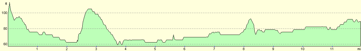
For more information on profiles, ascents and descents, see this page
Transport
There are busses about every half hour on route 172 from Bedford to Sandy during the week, and the trip costs £2.10 for a single ticket.
Disclaimer
Please note that I take no responsibility for anything that may happen when following these directions. If you intend to follow this route, then please use the relevant maps and check the route out before you go out. As always when walking, use common sense and you should be fine.
If you find any information on any of these routes that is inaccurate, or you wish to add anything, then please email me.
All images on this site are © of the author. Any reproduction, retransmissions, or republication of all or part of any document found on this site is expressly prohibited, unless the author has explicitly granted its prior written consent to so reproduce, retransmit, or republish the material. All other rights reserved.
Although this site includes links providing convenient direct access to other Internet sites, I do not endorse, approve, certify or make warranties or representations as to the accuracy of the information on these sites.
And finally, enjoy your walking!
Nearby walks
| # | Title | Walk length (miles) |
|---|---|---|
| 119 | Huntingdon to St Neots | 11.8 |
| 120 | St Neots to Biggleswade | 13.0 |
| 122 | Biggleswade to Hitchin | 11.6 |
|
|

|