Walk #213: Rushden to Northampton
 |
 |
|
General Data
| Date Walked | 21/08/2002 |
| County | Northamptonshire |
| Start Location | Rushden long-stay car park |
| End Location | Greyfriars Bus Station, Northampton |
| Start time | 09.14 |
| End time | 15.53 |
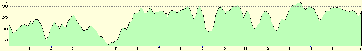
| Distance | 16.4 miles |
| Description | This was a nice walk westwards from Rushden to Northampton, following in part the Nene Way. |
| Pack | Today I carried my 30-litre Karrimor Hotrock rucksack, which contained a fleece, waterproof coat and trousers along with the usual assortment of odds and ends, including three litres of water. |
| Condition | I feel relatively fine after this walk. I feel slightly fatigued and I have a slight hotspot on the ball of my left foot, but aside from these I am fine. I could easily have walked further after a little rest, which is always a good sign after a walk of this length. |
| Weather | The weather today was fine, and started off with very few clouds in the sky. As the day went on it got hotter and hotter until it reached the early twenties. There was a little breeze, but this did very little to help me cool down. As the day went on the amount of cloud cover slowly increased. |
| OS map | Landranger number 153 (Bedford & Huntingdon, St Neots & Biggleswade) and Landranger number 152 (Northampton & Milton Keynes) |
 |
 |
|
 |
 |
|
Map of the walk
Maps courtesy of Google Maps. Route for indicative purposes only, and may have been plotted after the walk. Please let me have comments on what you think of this new format. For a detailed table of timings for this walk, please see the table file.
Notes
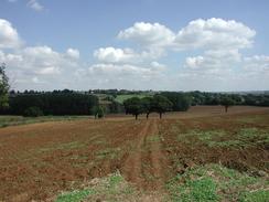
The aim of this walk was to do the last section of a walk from Huntingdon to Northampton. The gap remaining could have been done in two legs, but I chose to do it in one so that I could walk elsewhere another day.
The main church in Wellingborough, St Mary's, is a very nice church, but unfortunately I could not really get a nice photograph of it as the tower and spire were covered in scaffolding. The war memorial opposite it is also quite nice, and was very worthy of a photograph. Whilst heading out of Rushden along Wellingborough Road I stopped off at a sandwich shop and had a bacon and egg bap, which helped keep the pangs of hunger away for a short period.
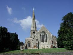
The Church of St Katharine's in Irchester apparently has one of the tallest and most elegant spires in Northamptonshire, and I stopped to study it for a few minutes.
I had recently had my X-Adventure 7 boots fixed where a seam had gone, but unfortunately I discovered when walking through a pasture with long grass that the repair was far from waterproof. The long grass was heavy with dew, and my socks soon got damp through the repair. Fortunately they did not get too wet and I did not find them uncomfortable during the rest of the walk.
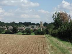
The Irchester Country Park was very nice, and the paths through it were generally well made and very wide. The whole area looked very sculpted, with many different levels that made it look as though it had been an old quarry of some form or another - since it is in Northamptonshire I would hazard a guess that it had been an ironstone quarry. Past the visitor's centre in the park is a little narrow-gauge railway museum, which is open on Sundays from 10 a.m. to 4 or 5 in the afternoon. Although it was shut I could see that this had quite a nice little collection of railway memorabilia, including a steam locomotive and an old Simplex platelayers wagon.
I had a quick stop on a bench outside the Cottage pub in Little Irchester so that I could change the batteries on my digital camera, which had unfortunately run out. Near the bench was a lovely little village sign of Little Irchester.
It had been my intention to follow the Nene Way south-westwards from Little Irchester, and so I started walking along the towpath. After about a quarter of a mile I reached a lock on the river and could see that the towpath ahead looked very overgrown. As I approached the overgrown section I found a sign stating that the path ahead was shut due to a bridge that was in a dangerous state. There was not a sign stating a diversion, or when the closure was meant to end. Due to the overgrown state of the path ahead I assumed that the closure was still in place, so I decided to plan another route. Unfortunately due to the lack of footpaths in the area it became clear that I had no choice but to walk back into Little Irchester and continue along roads from there. Quite why a notice could not have been put by the road stating that the path was closed I do not know; it would certainly have saved me a bit of a walk.
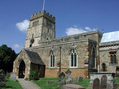
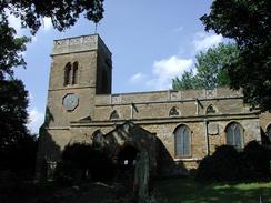
All Saints Parish Church in Earls Barton was quite nice, and it had a quite unusual tower, which had an exterior door about halfway up it. Where this once led to I cannot imagine, but it fitted in well with the rest of the architecture of the tower. After I had spent a couple of minutes looking at the church I descended down to a pub that is by the church where I had a pack of crisps and a pint of orange and lemonade. Unusually for me I failed to record the name of the pub, but I can remember that it was quite nice inside and played lots of good eighties music which I enjoyed listening to.
The village of Ecton was filled with buildings made of a sandstone that had a lovely yellowish colour to it, and this made the whole village look lovely, especially in the sunshine. The church in Ecton is the Parish Church of Saint Mary Magdalene and is near the imposing hall.
I have always liked Northampton, as I have a friend who used to visit when he lived in the city. I found it quite refreshing to recognise streets and areas I had not visited for over five years, as if I had just rediscovered a long-lost friend. I liked the market and Abington Street in particular; I remember hanging around there on several occasions whilst waiting for people.
The next walk in this area looks likely to be one from Northampton down to Blisworth on the Grand Union Canal and then onto Towcester or beyond. This will mean that I have connected up this walk and points further eastwards such as Huntingdon directly with the Grand Union Canal.
Directions
This walk starts off in the long-stay car park in Rushden, which is free to park in and is next door to the Rushden recycling centre. Leave the car park and turn right down the road heading towards the St Mary's Church. At a crossroads continue straight on, passing to the right of a council building and the Canargie public library and past the church until you get to the war memorial on the right.
At the war memorial turn right down Skinners Hill and head down towards a large roundabout. At a pedestrian crossing cross over to the left-hand side of the road and continue to the roundabout. Once there cross over St Mary's Avenue and continue straight on up Wellingborough Road.
The road climbs up a slight hill past a gospel church and Rushden Mission Church before it flattens out and reaches the junction with the B569 road. At the junction turn left down the B569, which is called Irchester Road. The road climbs up a little hill and past a concrete water tower before descending through Knuston to cross a little stream before climbing uphill once more to a bridge over a railway line. The road then turns to the left and becomes Station Road as it enters Irchester.
When the road turns sharply to the left opposite some thatched cottages turn right down High Street and walk past the library until you get to St Katharine's Parish Church. Continue past the church and than take the first road to the left, St Katharine's Way, which has a signpost for the Nene Way which will be followed for a couple of miles. When the road curves to the right a path continues onwards down a track between two graveyards.
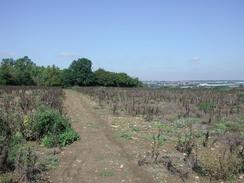
The Nene Way then continues straight on between two metal fences as a footpath, which then curves around to the right around the end of one of the graveyards before entering a field. At the field turn half-left across the field to head towards the right-hand corner of an area of woodland. When the woodland is reached descend some steps down into the Irchester Country Park. At the bottom of the steps turn to the right and follow a path, which is still part of the Nene Way. The path is quite broad initially and has a very good walking surface. The path continues downhill for a short distance and when it turns to the left continue straight on to emerge out of the trees into a field.
Once in the field angle half-left towards where the trees meet the A45 road. On the other side of the field the path enters the woodland once more via a clapper gate and turns to the right to head towards the A45 road. It then emerges onto a lay-by on the A45 where there is a handy truck stop and little cafe. Turn left down the lay-by and then just before it rejoins the A45 turn left down a path into the woodland once more.
The path joins a wide track that continues on through the woodland. It eventually emerges at a car park for the visitor's centre for the country park. Continue through the car park and along a surfaced road before passing under some high-tension power lines and to the left of the toilets for the visitor centre. From the visitors centre continue straight on following a sign for a railway museum along a very firm and wide track.
Just before the railway museum is reached turn right down another slightly narrower track, which heads through bushes and continue until you reach some steps to the left. Climb up these steps and continue down a narrow path with a fence on the left and a hedge on the right. This path twists and turns slightly past some allotments until it reaches Milton Road.
Turn left down Milton Road and follow it for a short distance until it meets the A509 London Road beside a corner shop and post office. Turn right down the A509 towards a bridge under the A45 road, passing the Cottage pub and Daniel's road on the way. Continue along the road as it passes under the A45 and then immediately afterwards crosses over the River Nene on a bridge.
On the far side of the bridge the Nene Way heads off to the left which would be a far more scenic route than the one I chose to do, but this section of the Nene Way was closed when I walked this route so I had to continue onwards for a short distance to the roundabout with the A5193 road. At the roundabout turn left past a Tescos store along a short section of dual carriageway called Turnells Mill Lane. There is a pavement on the northern side of the road, beside the Tescos store. Continue along to a roundabout which has slip roads leading off up onto the A45 and take the first exit to the right, which is still called Turnells Mill Lane.
Pass under some high tension power lines and climb up a alight hill until it climbs higher than the A45, which is in a cutting to the left. When the road ends at a T-junction turn left up Doddington Road and cross over the bridge over the A45 road. Pass the slip roads that lead down onto the A45 and continue along the road as it turns to the right and the road becomes the Ridge.
Enter Great Dodddington past the Stag's Head which was a riot of pinks and purples with a lovely display of flowers in the window and floor boxes. Past the pub the road curves to the right and becomes High Street and passes the village green. When Church Lane is met on the right turn up it and head a short distance uphill to St Nicholas Church. Turn left to enter the churchyard and continue on to a little cross commemorating a Bishop in the churchyard. At the cross turn left and leave the churchyard before passing down a tarmac path between two walls that leads back to the High Street.
At the High Street turn right and follow it south-westwards out of the village. When Lower Street comes in from the left High Street becomes Earls Barton Road. The road continues with the pavement on the left as it goes over a crossroads and onwards to meet a bridge over the A45. Just after the bridge the pavement changes from being on the southern to the northern side of the road, so cross over and sontnue on to enter trhe village of Earls Barton.
As the road enters Earls Barton it becomes Doddington Road. Continue on along the road until you get to the centre of the village, with the church on a hill to the right. At a T-junction follow the road as it heads up to the left of the church, and with a nice pub on the left. The road curves around to the left and becomes West Street as it heads westwards to end at a T-junction with the B573 Northampton Road.
At the junction turn left down the B573 road for about fifty yards and then turn right through a little gate into a field. Descend through the field towards the right-hand edge of an area of woodland. About a hundred yards away to the right is an old ramshackle farm that should be avoided. When the trees are met climb over a stile and follow the edge of the trees until they end at a stream. Cross the stream using a small footbridge and then start climbing up through another field straight on between three trees until you get to the driveway, which leads to South Lodge. On the other side of the driveway continue straight on across another field towards the top of the hill, where the Northampton lift Tower can be seen in the distance ahead. The path continues across several fields before ending at the surfaced Barton Fields Road. This road is followed for fifty yards before it ends at a T-junction with the High Street.
At this road turn right and head northwards through the little village of Ecton. Continue on past the Three Horseshoes pub and the church is up Church Lane to the right if you want to visit it., and if not continue on up the road. A little further on the High Street becomes Northampton Road next to the war memorial and passes to the right of a school. Just after the school turn left down Franklin's Close. At the end of the close turn left and pass to the right of a concrete garage before climbing over a stile into a field.
Head down towards the bottom of the field and then climb up the other side, crossing two stiles in the process. In the corner of the second field the stile leads out to another field, with a hedge on the left. Follow this hedge as it climbs uphill westwards and then descends down to a narrow band of woodland.
Enter the woodland and cross a small stream by a wooden bridge before meeting a lake. Turn left and then right to skirt the end of the lake until the path meets a fence. At the fence turn left and follow the fence until there is a gap in the fence to the right that leads onto a cul-de-sac. Turn left down the road and then right down another one for fifteen yards and then left down Vantage Meadow. At the end of Vantage Meadow turn right and follow a road past a stop, where a path leads off to the right. Descend down this path and then turn left to join a tarmac path, which leads under the road using a bridge.
Follow the path westwards as it passes a small children's play area and then tunnels under the A5076 Great billing Way before ending at a large clapper gate. The path continues on the other side of the gate until it ends at a white gate. Go through the gate and cross the road, which is called High Street, and continue on down Church Walk, which is straight ahead. Continue on past a combined gate and stile along a road that leads on towards St Andrew's Church, Great Billing.
As the road curves around to the right continue straight on and descend down a field, aiming to skirt the right-hand edge of a housing estate. This path descends down the hill across a field and ends at Fishponds Road. At the road turn right and follow it as it bends around to the left and starts to climb uphill once more. When the road ends at a T-junction turn right down Little Billing Way for a few hundred yards before it too ends at a junction with the A4500 Wellingborough Road.
Turn left and follow Wellingborough Road westwards to the roundabout with Billing Brook Road and then head on past the large junction with the A43 Lumbertubs Way. Continue on along Wellingborough Road until a pedestrian crossing is reached. Use the crossing to get to the southern side of the road and then continue on to the left down High Street past the Bold Dragoon pub towards St Peter's Church, Weston Favell.
Pass the church and then turn right up Churchway until some no-entry signs are reached. Here turn left along Weston Way and follow it until it ends at a T-junction. At the junction continue straight on and enter Abington Park down a path. The path heads downhill and enters a narrow band of woodland before reaching a boating lake. At the lake turn left and skirt the southern end of the lake before leaving it and climbing uphill along a tree-lined avenue that ends at the western end of the park at Park Avenue. The Parish Church of SS Peter and Paul, Abington is a little way up the road to the right.
At Park Avenue continue straight on down Christchurch Road ahead until it ends at the A4500 Wellingborough Road. Join Wellingborough Road and follow it westwards. It passes a junction with the A5123 Kettering Road to the right and becomes Abington Square and then soon ends at a T-junction with Lower Mounts Street.
At this junction continue straight on down the pedestrianised Abington Street until the Market Square becomes visible on the right. Turn right and pass through the market and enter the Grosvenor Shopping Centre, which is on the northern side of the market. The bus station is on accessible from the second floor of the shopping centre.
Distances
| From | To | Distance (m) | Ascent (ft) | Descent (ft) |
|---|---|---|---|---|
| Rushden | Irchester | 2.7 | 187 | 97 |
| Irchester | Earls Barton | 6.0 | 384 | 331 |
| Earls Barton | Northampton | 7.7 | 551 | 531 |
This makes a total distance of 16.4 miles, with 1122 feet of ascent and 959 feet of descent.
For more information on profiles, ascents and descents, see this page
Transport
Regular busses run from Northampton to Rushden, usually at hourly intervals. The main bus service is service 46, which is operated by First Northampton and which leaves from Bay 8 of the station. In my case the bus was due to leave at 15.50, but it was few minutes late so I managed to catch it and therefore thankfully I did not have to wait for an hour.
Disclaimer
Please note that I take no responsibility for anything that may happen when following these directions. If you intend to follow this route, then please use the relevant maps and check the route out before you go out. As always when walking, use common sense and you should be fine.
If you find any information on any of these routes that is inaccurate, or you wish to add anything, then please email me.
All images on this site are © of the author. Any reproduction, retransmissions, or republication of all or part of any document found on this site is expressly prohibited, unless the author has explicitly granted its prior written consent to so reproduce, retransmit, or republish the material. All other rights reserved.
Although this site includes links providing convenient direct access to other Internet sites, I do not endorse, approve, certify or make warranties or representations as to the accuracy of the information on these sites.
And finally, enjoy your walking!
Nearby walks
| # | Title | Walk length (miles) |
|---|---|---|
| 137 | Market Harborough to Northampton | 18.3 |
| 142 | Huntingdon Station to Hargrave | 17.3 |
| 157 | Wolverton to Bugbrooke | 16.6 |
|
|

|