Walk #119: Huntingdon to St Neots
 |
 |
|
General Data
| Date Walked | 30/09/2000 |
| County | Cambridgeshire |
| Start Location | Huntingdon |
| End Location | St Neots |
| Start time | 10.10 |
| End time | 14.50 |
| Distance | 11.8 miles |
| Description | This was a very nice walk following the River Great Ouse south to St Neots. |
| Pack | Today I carried a minimal pack, with no tent or spare clothes. |
| Condition | I feel fine after this walk. I am slightly tired, but that is mainly due to a lack of sleep last night than any exertions on this walk. I wore my X-Adventure 7 boots, and my feet have not suffered at all, and my legs, shoulders and back are okay, probably due to the fact that I did not carry a heavy pack. |
| Weather | The weather today was very nice, with a mixture of sunshine and cloud. There was no rain until I had caught the train back to Huntingdon, when it started to rain heavily whilst I was trying to find my car in the car park. All in all this was a very nice day for a walk. |
| OS map | Landranger number 153 (Bedford & Huntingdon, St Neots & Biggleswade) |
 |
Map of the walk
Maps courtesy of Google Maps. Route for indicative purposes only, and may have been plotted after the walk. Please let me have comments on what you think of this new format. For a detailed table of timings for this walk, please see the table file.
Notes
This was a very nice walk following the River Ouse upstream as it meanders south towards it's source. There are some nice views of the River Ouse available, but you are always aware that you are not too far away from the main London to Edinburgh East Coast Main Line, or indeed in places the A1 can be heard. Nonetheless it was a very pleasant walk on a nice day.
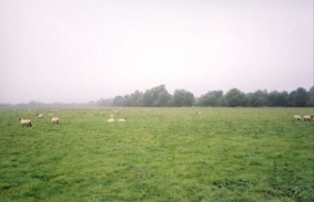
Water dominates this walk, with the River Great Ouse to your left as you head south and to the right are frequent lakes, the flooded remains of gravel pits (apparently the gravel from the pits went to make parts of the M1 and A1 roads, amongst other things). There were also frequent boats along the river which were a nice and pleasant sight.
During my short rest break opposite Great Paxton four ramblers passed me, and as I was getting up another couple of people approached. I started to chat to them as we walked southwards and they were part of a group of about sixty ramblers (all members of a caravan club) who were walking the 27 miles of the Ouse Valley Way in three stages, this being their last one. it was nice to have some company for a bit, so we chatted about trivialities for a while before I went ahead of them on the outskirts of Little Paxton.
When I reached the B1041 on the northern edge of St Neots I could have turned left down a minor road which would have led me for just over a mile to the railway station. Since I was feeling fairly fit and wanted to see the town, however, I continued following the Ouse Valley Way for a while across Islands Common to the town centre and the B1248, which I then turned down to lead me east towards the station. This section of the walk included the only mud that had been seen all day, where the Ouse Valley Way went through a gate and the cows had churned up the ground. As always, sod's law came into play and the mud had to be at the end of the walk, leaving me with muddy boots for the train journey home! It also made me slightly wary about visiting a pub (The Falcon) in the centre of the town, but when I saw the state of some of the other inhabitants of the pub I decided to enter anyway.
According to the lady at the Tourist Information office in St Neots there are plans to extend the Ouse Valley Way from St Neots to Bedford, but the route is not yet finalised. This should be a very nice (and handy route), but it looks as though I shall have to invent my own route as I doubt that the official one will be ready before I am ready to walk that section.
Directions
I parked my car at the railway station in Huntingdon, which has a free car park at weekends. Since my previous walk from Waterbeach had ended at the bus station, I left the railway station and turned right up the B1514 into the center of Huntingdon, passing an old cannon (a relic of the Crimean war) on the right. When the road ended at a T-junction with the ring road, I turned right and followed the ring road eastwards past the bus station. Immediately opposite the bus station a road led off under the A1 to the right, and after passing under the A1 it crossed over a small brook and then onto the Port Holme meadows, which are apparently Britain's largest remaining intact water meadows, and which in time gone by have been used as an Aerodrome and racecourse. These meadows still regularly flood most winters.
At the southern end of the bridge two footpaths depart. Take the path to the right that skirts along the brook for a short time before heading southwestwards across the meadows, heading slowly towards the East Coast Main Railway Line. Just before the railway line is reached the path joins the Ouse Valley Way, and this continues under the railway via a bridge.
As the path passes under the railway it becomes a track, and this track continues westwards for a short while before turning to the left to head south and deposits you in a caravan park. Pass through the park and join the river again. (Note, it is easy to go wrong in the park and take a more obvious footpath that leads across a golf course. if you reach the golf course you have gone wrong; turn around and head back to the caravan park; turn right and follow a path that leads through the park to a gate. Go through the gate and turn right along the track, and the Ouse Valley Way markers should now be visible).
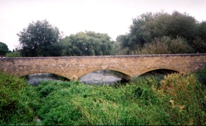
The Ouse Valley Way slowly meanders in a generally southwards direction, and it is very hard to get lost on this section due to the very high quality of the way markers. Just north of Offord Cluny the path leaves the river and goes though a very nice marina with chalets raised up on stilts. The path through the marina deposits you on the Buckden to Offord Cluny road, which you turn left down and, shortly after going round a sharp-right hand bend, a path leads off across fields to the right. Follow this path past some weirs and then beside a broad stream before reaching a bridge that takes you over the stream. Turn left at the other end of the bridge and follow the path to meet the River Great Ouse again. This then bends around to head south.
The next three miles are quite simple to follow as the path heads southwards between the river and occasional lakes. For a short section opposite the village of Great Paxton the river is left, but again this is well way marked and it would be hard to go wrong. Shortly after this the river starts heading to the southwest and eventually leads to the village of Little Paxton. The path follows the river still across the front of some houses before depositing you on the B1041 road.
Turn left along the B1041 and cross the river by the bridge, and then walk along a raised section of path which passes over some weirs. At the other end of this raised path a road junction is met. If you want to get to St Neots station quickly, then turn left along this road. If you want to walk into the centre of the town, take a path to the right opposite the road junction that heads across fields on Islands Common. This path soon meets the river again, which is skirted for a short period before the southern end of the Common is reached and the path is forced away from the river.
Follow the Ouse Valley Way for a short distance through St Neots until the B1428 road is reached. Turn left down this road and follow it for just under a mile eastwards to a roundabout just before a bridge under the railway line. Take a road leading off tote left that leads straight to St Neots railway station.
Distances
| From | To | Distance (m) | Ascent (ft) | Descent (ft) |
|---|---|---|---|---|
| Huntingdon railway station | Offord Cluny | 4.4 | 62 | 85 |
| Offord Cluny | Little Paxton | 4.5 | 49 | 29 |
| Little Paxton | St Neots railway station | 2.9 | 56 | 13 |
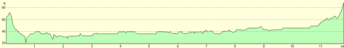
This makes a total distance of 11.8 miles, with 167 feet of ascent and 127 feet of descent.
For more information on profiles, ascents and descents, see this page
Transport
There are regular train services on the East Coast Main Line between St Neots and Huntingdon stations. There are also bus services linking the two towns.
Disclaimer
Please note that I take no responsibility for anything that may happen when following these directions. If you intend to follow this route, then please use the relevant maps and check the route out before you go out. As always when walking, use common sense and you should be fine.
If you find any information on any of these routes that is inaccurate, or you wish to add anything, then please email me.
All images on this site are © of the author. Any reproduction, retransmissions, or republication of all or part of any document found on this site is expressly prohibited, unless the author has explicitly granted its prior written consent to so reproduce, retransmit, or republish the material. All other rights reserved.
Although this site includes links providing convenient direct access to other Internet sites, I do not endorse, approve, certify or make warranties or representations as to the accuracy of the information on these sites.
And finally, enjoy your walking!
Nearby walks
| # | Title | Walk length (miles) |
|---|---|---|
| 108 | Waterbeach to Huntingdon | 21.6 |
| 120 | St Neots to Biggleswade | 13.0 |
| 142 | Huntingdon Station to Hargrave | 17.3 |
|
|

|