Walk #487: Ferlochan to Duror
 |
 |
|
General Data
| Date Walked | 01/07/2003 |
| County | Strathclyde, Highlands |
| Start Location | Ferlochan |
| End Location | Duror |
| Start time | 09.00 |
| End time | 17.03 |
| Distance | 21.3 miles |
| Description | This was a fairly entertaining walk, but it included too much road walking for my liking. |
| Pack | Today I carried my 30-litre Karrimor HotRock rucksack, which was filled with my packed lunch, waterproof leggings, water bottle and a couple of spare shirts, together with the usual assortment of odds and ends. |
| Condition | I feel absolutely fine after this walk, and I have no significant problems to report. My left ankle ached slightly at times, although I doubt that this was due to using my new trainers. |
| Weather | Today was a day of sunshine and cloud, with the occasional short and sharp shower. These were few and far between, and were never heavy enough to force me to put my coat on. There was quite a fierce wind at times, and this was quite chilly when clouds obscured the sun. |
| OS map | Landranger number 49 (Oban & East Mull) |
 |
 |
|
 |
 |
|
Map of the walk
Maps courtesy of Google Maps. Route for indicative purposes only, and may have been plotted after the walk. Please let me have comments on what you think of this new format. For a detailed table of timings for this walk, please see the table file.
 |
 |
|
 |
Notes
Sam had to travel back to Kilmartin this morning to pick up some post that had been sent to us using the poste restante service, and on the way back she called in to the Oban Sealife Centre for a few hours. Sam loves the sea and sealife, and apparently she enjoyed watching the seals and otters being fed, and actually got to feed the sharks (fortunately they had shark food and did not need to use the visitors as bait!)
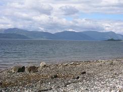
The initial part of the walk along the road was not too bad, even though it was along a main road. The traffic was not too busy, and the views made the walk more bearable. A highlight was the bridge over Loch Creran at Creagan; he bridge itself was not of any aesthetic value, but the views from it up and down the loch were superb, and it made that little stretch of walk worthwhile. Having said that, I was glad enough to get off the main road and onto a quiet minor road that lead around to Port Appin; unfortunately views were sparse, however, as the road ran slightly inland.
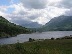
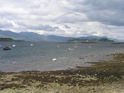
Port Appin was a beautiful place, and the short walk down to the hotel by the pier passed quickly. I was in need of a rest and a pint, and so I slunk into the lovely hotel and asked if they allowed non-residents in. The place we busy with people eating lunch, and after an affirmative answer I sat down in the bar area. The view from the hotel over Loch Linnhe was absolutely superb, and the view of the high mountains was awe-inspiring. I could easily have sat there all day, but some grey clouds were starting to move over and so I decided that it would be best to move on and miss any rain. On the way out of the village I passed the village store, which appeared to be a thriving business in a relatively remote area - something that I always like to see.
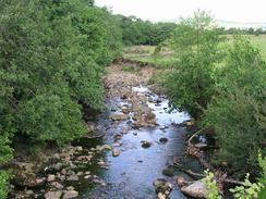
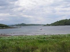
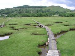
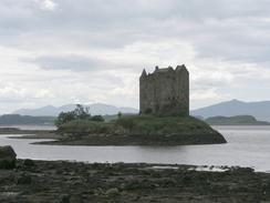
There were a couple of showers, but these were not prolonged and I just kept on walking along the road. Across Loch Laich I could see the impressive sixteenth-century Castle Stalker clearly, built on a small island in the loch. Instead of walking along the road back to the A828(T) I decided to use a path marked on the Ordnance Survey map which led northeastwards across the loch. The path was relatively good, and led to a long wooden bridge over the loch. The view from the bridge was fantastic, and although it was a bit rickety it was good enough. On the northern side there was a boarded causey across some marshes, and despite the fact that this was showing signs of age with boards missing it was easy to walk along without getting my feet wet.
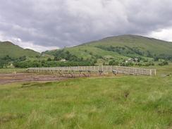
All the road walking that I have been doing recently is slightly boring, so instead of joining the A828(T) I chose to walk along the trackbed of an old railway line instead. This kept me away from the road for a couple of miles and made for a much more interesting walk, but in places the path was quite boggy and wet.
I wore my new trainers today, the fist complete day that I have used them. They were fairly comfortable, even when I got the right one muddy and wet when walking along the old railway line. This has made me realise exactly how worn the old pair were - I am literally bouncing along the road with all the extra cushioning that they give me.
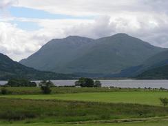
Towards the end of the walk I crossed the border between Argyll and Bute and Highlands, and this was a border of some significance; I am going to be in Highlands for some time (until I get near to Inverness), and it is the last county of any significant size that I will be passing through. As I passed the sign the entry into the Highlands became obvious, with the mountains across Loch Linnhe looking stunning (I will have to walk past them in a few days time).
I finished the walk at a lay-by on the A828(T), and as this was not really a sensible place to spend the night we drove north along the road, hoping to find somewhere that we could park. Thankfully the owner of the MacDonald Arms Hotel in Duror allowed us to park in their car park, and we had a drink in the hotel later on. They also allowed us to top up our water tank, which allowed us both to have some (in my case much-needed) showers
Directions
This walk starts off on the A828(T) road at Ferlochan.Head northeastwards along the road, passing through Barcaldine before reaching the bridge over Loch Creran at Creagan. Continues along the road westwards for a mile and a half until a road junction is met on the left. Turn down this road and follow it southwestwards for a couple of miles. Just after Rudha Garbh it turns to the right to head in a rough northwesterly direction for another couple of miles until the road ends at a junction. At the junction continue on along the new road past the village hall and the shop until the Pier House Hotel is reached by the pier.
Retrace your steps back to the road junction, and follow the road northeastwards out of Port Appin and past the southern end of Loch Laich. When the road turns to the right turn left down a path that heads along the foreshore for a short distance to a wooden bridge, which takes you northeastwards across the loch. On the other side of the bridge the path continues on along a short wooden causey to an embankment of an old railway line. A path, which is sometimes muddy and boggy, runs along the top op the embankment, so turn left and follow the path northwestwards. After a kilometre this turns to the right to head in a more northerly direction, and eventually becomes a good track before ending at a car par beside the A828(T). Continue northeastwards along the A828(T) until the primary school in Duror is reached, where this walk ends.
Distances
| From | To | Distance (m) | Ascent (ft) | Descent (ft) |
|---|---|---|---|---|
| Ferlochan | Port Appin | 12.4 | 1063 | 1089 |
| Port Appin | Duror | 8.9 | 656 | 646 |
This makes a total distance of 21.3 miles, with 1719 feet of ascent and 1735 feet of descent.
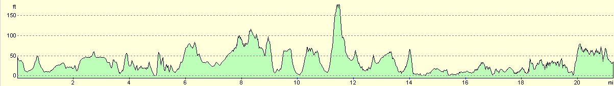
For more information on profiles, ascents and descents, see this page
Accommodation
We spent the night in the car park of the MacDonald Arms Hotel in Duror, who were kind enough to let us stay there and fill our water tank.
Disclaimer
Please note that I take no responsibility for anything that may happen when following these directions. If you intend to follow this route, then please use the relevant maps and check the route out before you go out. As always when walking, use common sense and you should be fine.
If you find any information on any of these routes that is inaccurate, or you wish to add anything, then please email me.
All images on this site are © of the author. Any reproduction, retransmissions, or republication of all or part of any document found on this site is expressly prohibited, unless the author has explicitly granted its prior written consent to so reproduce, retransmit, or republish the material. All other rights reserved.
Although this site includes links providing convenient direct access to other Internet sites, I do not endorse, approve, certify or make warranties or representations as to the accuracy of the information on these sites.
And finally, enjoy your walking!
This walk was mentioned in the following routes:
| My walk around the coastline of Britain |
Nearby walks
| # | Title | Walk length (miles) |
|---|---|---|
| 486 | Kilmore to Ferlochan | 16.4 |
| 488 | Duror to Fort William | 22.7 |
| 491 | Camusnagaul to Inversanda | 17.0 |
|
|

|