Walk #168: Cromer to North Walsham via Mundesley
 |
 |
|
General Data
| Date Walked | 25/11/2001 |
| County | Norfolk |
| Start Location | Cromer bus station |
| End Location | North Walsham Station |
| Start time | 09.30 |
| End time | 14.05 |
| Distance | 12.8 miles |
| Description | This was a nice combination of coastal, road and footpath walking which led to a high;y enjoyable varied walk. |
| Pack | I carried a 30-litre daysack containing coat, trainers, digital camera and a spare top. |
| Condition | I am generally okay after this walk and am slightly less fatigued than I was after yesterdays walk which is a good sign. The biggest problem that I have is that I have soreness on the inside of my thighs where my boxer shorts have been rubbing, which is slightly painful. |
| Weather | The day started off fairly nice as I walked along the beach, with about 25% clear sky and the rest being broken, high cloud. As I walked on the cloud started to thicken, and just before I reached Mundesley it started to lightly rain. When I reached the town it started to rain more heavily, and it continued on and off until I got to North Walsham. A digital temperature gauge on the wall of a garage showed the temperature to be 12 degrees Celsius, but it felt colder due to my being damp after the rain and the slight wind. |
| OS map | Landranger number 133 (North East Norfolk, Cromer & Wroxham) |
 |
 |
|
Map of the walk
Maps courtesy of Google Maps. Route for indicative purposes only, and may have been plotted after the walk. Please let me have comments on what you think of this new format. For a detailed table of timings for this walk, please see the table file.
Notes
This walk included the last section of the Norfolk coast that I had left to do, that being the seven mile stretch between Cromer and Mundesley. Because this was a fairly short walk, I decided to extend the walk by walking inland along roads and footpaths to the little town of North Walsham.
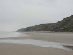
The initial stretch of the walk along the beach was highly enjoyable, and fortunately for the majority of the time it was not raining. The cliffs along this part of the coast are quite high, and so I had been slightly concerned that the beach would be impassable if it was a high tide or stormy weather. As I walked along this proved not to be the case, with a wide expanse of mostly sandy beach providing some good walking terrain.
In places (particularly just to the north of Mundesley) the groynes were quite difficult to get past, with one end in the sea and the other end embedded into the cliff. One in particular required a climb of seven or eight feet to get over, which I manages to do after a few seconds though about where the best foot- and hand- holds were. I then helped a few members of a family over, in particular one lady who seemed to think that she could not make it over.
Yet again I have managed to do a decent-sized walk with no stops, which shows that I am thankfully fairly fit. Over this winter I will start to push this number up by increasing my average mileage per walk, so that I am ready for some of the harder walks that I have scheduled for next year.
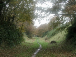
The map showed a footpath leading along the old Mundesley to North Walsham railway line from just south of Knapton into North Walsham itself. Since this looked like being a much better alternative than walking along the road, I decided to follow this line instead. What followed was a pleasant tree-lined route, initially in a cutting but later on on an embankment, with little mud to hinder progress.
Near the end of this section the map showed the path crossing over a little river (which a sign said was the Dilham Canal). As I approached the site of this bridge I could see that it was blocked off by a large back fence, which worried me. It was only when I got to the site that I realised that some steps lad down to the embankment to a simple bridge over the canal, and then up again on the south side of the bridge. This was a relief as I had started to think that I may have to go back and find another route to get over the canal.
When I got to North Walsham I had a little over an hour to wait for the train back to Cromer. Since I was damp and there was a cold wind blowing I decided to visit the taxi office at the station and enquire about a taxi. It turned out that a taxi would have been about ten pounds (instead of about two for the train), and would not be able to get here for an hour anyway, so I decided it was far more sensible to wait for the train. This gave me time to sit in the waiting shelter on the platform and write up my notes on my Psion 5.
I now only have one walk, from Ely to Littleport, to do before I have finished my walk around East Anglia. This is a slight untruth as I walked that part of the route back in late 1998 as part of a walk from Waterbeach to Littleport. However as this was before I routinely logged my walks I am going to have to do it again so that I can get some photographs and some notes of the walk.
Directions
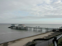
This walk starts at the bus station in Cromer. From the bus station head down the main road towards the Esplanande that runs along the top of the cliffs above the sea. When the Esplanade is reached turn left to descend down to the beach via some steps.
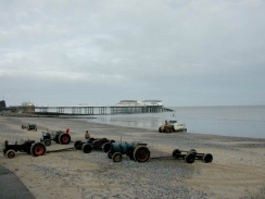
Turn right and head east along the beach or the front, passing by or under the pier. Continue along until the end of the seawall is reached, and from here it is simply a case of following the beach southeastwards for a couple of miles until Overstrand is reached.
Continue along the beach southeastwards from Overstrand, passing past the cliffs below Sidestrand and then Trimmingham. Eventually after about five miles the little town of Mundesley is reached. Continue on past the first few slipways up the beach until you reach one at TG 315 366, which leads up the cliffs (which are not very high at this point) to a narrow road beside the Ship Inn.
Continue up this road until it ends at a T-junction with the B1159 Beach Road. Turn right down this road, passing some shops on the right, until you reach the junction with the B1145 High Street.
Turn left down the B1145 and follow it southwards for a little under a kilometre until a bridge over a stream is reached. Immediately after this bridge there is a road junction. Turn left and then immediately right, to head south down the B1145 Knapton Road towards the village of Knapton. This road was not to busy, so I did not feel too endangered. After about a kilometre Pond Lane leads off to the left. Take this narrow road and follow it southwards to a T-junction in the village beside the church.
Turn right at the crossroads and head down The Street past the church. When another crossroads is reached turn left and head south for a kilometre down Hall Lane through the hamlet of Old Hall Street until a car park is reached on the right.
Here some steps lead down to an old disused railway cutting on the right. Go down these steps to the bottom of the cutting. Follow the cutting as it heads to the southwest. The path soon passes under another road bridge before it goes from a cutting to an embankment. It continues on for another kilometre until a black fence bars the way at the bridge over the old Dilham Canal.
At the canal some steps lead down to the left off the embankment. At the bottom of the steps a simple bridge takes you over the canal, from where some more steps lead up to the top of the embankment. At the top of the embankment turn left and after a short distance another road is reached. Drop down off the embankment and cross the road, climbing up to the top of the embankment again. Shortly after this the footpath goes into a cutting and ends at another bridge. Here some steps lead up to the left to the top of the cutting.
At the road at the top turn left and follow Mundesley Roads southwards. Pass the first junction on the left (Crow Road) and take the second a little further on (North Street). Follow North Street as it turns to the left and then turn right down Church Street. At the end of this short street continue almost directly straight on southwards down Yarmouth Road. Take the road to the first right (Grammar School Road) and follow it to the traffic lights at it's junction with the A149. Cross over the A149 and the railway station is a short distance ahead on the left. Trains back to Cromer depart from platform 2 on the other side of the railway bridge.
Distances
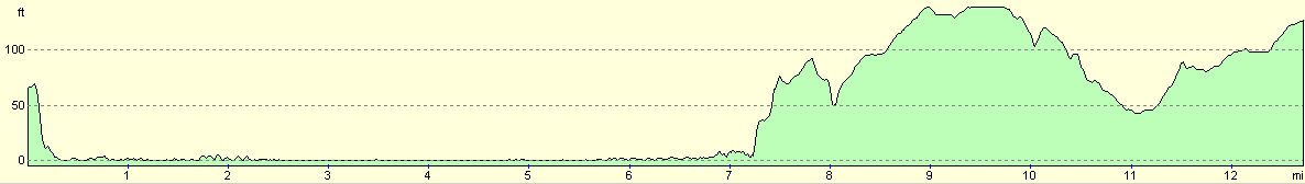
| From | To | Distance (m) | Ascent (ft) | Descent (ft) |
|---|---|---|---|---|
| Cromer | Mundesley | 7.3 | 230 | 282 |
| Mundesley | North Walsham | 5.5 | 308 | 194 |
This makes a total distance of 12.8 miles, with 538 feet of ascent and 476 feet of descent.
For more information on profiles, ascents and descents, see this page
Transport
Railway trains run between Cromer and North Walsham, running at two-hourly intervals on a Sunday. Mundesley does not have a Sunday bus service in Autumn or Winter, so the only alternative to get back to Cromer was to walk on to North Walsham and catch the train.
Disclaimer
Please note that I take no responsibility for anything that may happen when following these directions. If you intend to follow this route, then please use the relevant maps and check the route out before you go out. As always when walking, use common sense and you should be fine.
If you find any information on any of these routes that is inaccurate, or you wish to add anything, then please email me.
All images on this site are © of the author. Any reproduction, retransmissions, or republication of all or part of any document found on this site is expressly prohibited, unless the author has explicitly granted its prior written consent to so reproduce, retransmit, or republish the material. All other rights reserved.
Although this site includes links providing convenient direct access to other Internet sites, I do not endorse, approve, certify or make warranties or representations as to the accuracy of the information on these sites.
And finally, enjoy your walking!
This walk was mentioned in the following routes:
| A walk around East Anglia |
Nearby walks
| # | Title | Walk length (miles) |
|---|---|---|
| 163 | Sea Palling to Mundesley | 9.4 |
| 165 | Cley-next-the-Sea to Cromer | 13.1 |
| 215 | Wroxham to North Walsham via Aylsham | 16.2 |
|
|

|