Walk #163: Sea Palling to Mundesley
 |
 |
|
General Data
| Date Walked | 03/11/2001 |
| County | Norfolk |
| Start Location | Sea Palling lifeboat station |
| End Location | Mundesley |
| Start time | 10.00 |
| End time | 13.18 |
| Distance | 9.4 miles |
| Description | This was a lovely coastal walk, following the North Norfolk coastline as it heads towards Cromer. |
| Pack | I carried a 30-litre daysack containing coat, trainers, digital camera and a spare top. |
| Condition | I feel fine after this walk. I could easily have walked on for another three miles, as the early finish shows. Sam was not feeling too well however, so I thought that it was wise to stop at my objective and not continue on. I am also expecting to do a long walk tomorrow, possibly seventeen miles, so I decided to conserve my strength for that. |
| Weather | The weather today was quite warm for the time of year, and was only offset by wind-chill in the most exposed of places. I worse a long-sleeved base layer shirt and an short-sleeved one above it, and this was enough to keep my trunk warm even in the wind. The sun shone amongst scattered cloud for the first half of the journey, but after Ostend there were some ominous grey clouds overhead. Despite this it did not rain, and indeed the clouds started to part near the end of the journey. |
| OS map | Landranger number 133 (North East Norfolk, Cromer & Wroxham) and Landranger number 134 (Norwich & The Broads, Great Yarmouth) |
 |
Map of the walk
Maps courtesy of Google Maps. Route for indicative purposes only, and may have been plotted after the walk. Please let me have comments on what you think of this new format. For a detailed table of timings for this walk, please see the table file.
Notes
This was a very nice coastal walk along the north-east Norfolk coast. It was a combination of beach and clifftop walking, with a short section of road walking mixed in. In the end it turned out I could have walked along the beach for the entire distance, but just to the south of Happisburgh a headland jutting into the sea meant it was unclear whether I could continue along the beach - the sea in the distance was breaking very close to the headland. for this reason I scrambled up some very rough steps up to the clifftop and approached Happisburgh for the last few hundred yards by the clifftop path.
The coast near Happisburgh (pronounced Hayes-Borough) was very eroded, and the path diverted into a field where the previous well-worn path disappeared into the void off the edge of the cliff. On the southern edge of Happisburgh I reached a stretch of tarmac that went literally over the cliff, with only some portable fencing acting as a barrier to prevent people from walking over the edge. By the fence were a middle-aged couple on their bikes, and they told me that the road originally used to go southeastwards along the coast for a couple of miles as far as Eccles, but the road was long-gone. To illustrate this he pointed to the two old War World II pill-boxes which were visible on the clifftop. These were now only standing a couple of hundred feet from the clifftop, whereas a few decades ago they were hundreds of yards away. The sea defences end a few hundreds of yards from the south of the village and restart about a mile north, and so the village is currently undefended by and modern sea defences and may houses on top of the cliff are in danger of collapse into the sea. This is now a famous case on the viability of defending the coastline versus the obvious costs of such defences. The situation at Happisburgh is obviously not helped by the cliffs, which are quite high and appear to consist of quite loose sand. Indeed two villages, Shipden and Whimpwell, have totally disappeared into the sea over the years.
I had a lucky escape on the approach to Happisburgh. Whilst I was making my way to climb up the rough steps to the clifftop I felt that something was wrong and looked down. To my horror I saw the battery case cover of my GPS hanging from the cord around my neck, with no sign of the GPS unit itself. The cord attaches to the back of the battery cover, and when I had swapped batteries earlier and had obviously not tightened it up properly. I started walking back down the beach looking for it, and fortunately I found it lying face up about a hundred feet away.
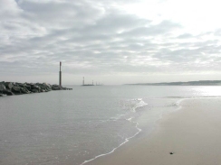
I also discovered that the pretty red-and-white lighthouse at Happisburgh had been painted in the television series "Challenge Anneka" many years previously. Apparently despite the fact that they were meant to be doing the painting in two days, they were on site for two weeks which corresponds with other stories that I have heard. It is a very nice lighthouse, looking very symmetrical from a certain angle with the two nice white houses alongside it. It was originally built in 1791 and had a companion low light 400 yards to the north (which was demolished in 1883), and has a range of 17.8 miles and is 94 feet tall.
Whilst in Happisburgh I nipped into the lifeboat station there and bought a small diary for 2002 - so that I can plan when I can afford time off in 2002. I also bought a history of the Happisburgh and Mundesley lifeboats. Two things come to mind when I skimmed through this booklet - firstly how much coastal erosion was shown in the maps within the booklet, and the other being the history of the lifeboats. I found it amazing that in the 1860's (when much of the population would never even have seen the sea) the Grocers of England paid for a lifeboat to be stationed at Mundesley, and the Great Eastern Railway company carried her to Mundelsey from Shadwell in London.
At Bacton there is a large natural gas terminal. Pipelines from several gas field in the North Sea reach land here, and the gas is distributed into other pipelines inland. I walked along the beach at this point, and the only obvious signs of the center were two large radio ariels and a security fence on the clifftop, and a pipeline coming inland sandwiched between two groynes. There was a slight smell of gas around this area, but this was hardly surprising as gs is naturally odourless and the smell is added one the gas reaches land.
Sam was a real trooper today. I was concerned about the situation with the bus services today, with the bus from Sea Palling due to get in at 14.00 I would not have much time to get from Mundesley to catch that bus at Stalham. I was aware of the problem, and Sam kindly agreed to come with me and drive the car up to Mundesley so that I could be picked up. This was very handy and also meant that I finished the trip earlier than would otherwise have been the case.
Directions
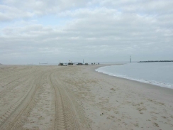
This walk started off at the beach at Sea Palling. The initial stretch of the walk heads northwestwards along the beach, following the coast. The sand is reasonably firm and therefore the going is not too hard. Continue for about five miles along the beach past Eccles on Sea until you reach the southern outskirts of Happisburgh. If you do not like walking on sand then much of this section has sea wall on which you can walk.
When the concrete sea defences end just to the south of Happisburgh you can choose to either follow the beach along or make your way up via some very rough steps up to the top of the cliffs. The beach route has to make its way past a couple of headlands that just out towards the sea, so only attempt this if the sea is far out. If you climb up to the top of the cliff then you are faced with the lighthouse. Turn to the right and follow the top of the cliff, being careful not to stray too close to the crumbling edge. When you reach a road that leads up to the edge of the cliff continue past a white house and skirt the cliff's edge to the lifeboat station. Continue on past here along a footpath that heads northwestwards across fields. This path passes a coastguard watch hut before meeting a new housing estate to the southeast of Ostend.
Here you have to leave the coast and you progress along the road through Ostend until the B1159 is reached. Turn right down the road and continue for a short distance until you reach the seafront at Walcott Gap. The road then turns to the left to head past a shop and a pub to skirt the seawall northwestwards. Leave the road and descend down steps to the beach.
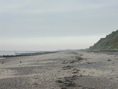
Turn left and head northwestwards along the beach. At the end of the sea wall past Bacton Green cliffs rise up, with a fence and poles with lights on visible at the top. This is the Bacton Natural Gas Terminal, and this is all that can be seen of it from beach level. The smell of gas, however, is present but is nothing to be concerned about. Continue on northwestwards until the cliffs get lower and buildings appear at the top. When you reach the Ship Inn turn left and climb up the ramp to the top of the low cliffs, where the main road through Mundesley is reached. A car park is a small distance away to the left.
Distances
| From | To | Distance (m) | Ascent (ft) | Descent (ft) |
|---|---|---|---|---|
| Sea Palling | Happisburgh | 3.6 | 138 | 98 |
| Happisburgh | Mundesley | 5.8 | 243 | 259 |
This makes a total distance of 9.4 miles, with 381 feet of ascent and 257 feet of descent.
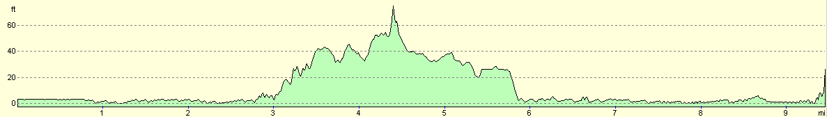
For more information on profiles, ascents and descents, see this page
Transport
There are bus services between Mundesley and Stalham, and other busses between Stalham and Sea Palling. Unfortunately the last bus to Sea Palling leaves before two in the afternoon, and the fact that I had to get to Stalham before that meant that it was difficult to get a connection. Therefore despite the fact that a connection was available I preferred to essentially to ask Sam to pick me up from the end of the walk.
Disclaimer
Please note that I take no responsibility for anything that may happen when following these directions. If you intend to follow this route, then please use the relevant maps and check the route out before you go out. As always when walking, use common sense and you should be fine.
If you find any information on any of these routes that is inaccurate, or you wish to add anything, then please email me.
All images on this site are © of the author. Any reproduction, retransmissions, or republication of all or part of any document found on this site is expressly prohibited, unless the author has explicitly granted its prior written consent to so reproduce, retransmit, or republish the material. All other rights reserved.
Although this site includes links providing convenient direct access to other Internet sites, I do not endorse, approve, certify or make warranties or representations as to the accuracy of the information on these sites.
And finally, enjoy your walking!
This walk was mentioned in the following routes:
| A walk around East Anglia |
Nearby walks
| # | Title | Walk length (miles) |
|---|---|---|
| 155 | Caister-on-Sea to Sea Palling | 12.5 |
| 168 | Cromer to North Walsham via Mundesley | 12.8 |
| 215 | Wroxham to North Walsham via Aylsham | 16.2 |
|
|

|