Walk #164: Royal Leamington Spa to Solihull
 |
 |
|
General Data
| Date Walked | 04/11/2001 |
| County | Warwickshire, West Midlands |
| Start Location | Leamington Spa |
| End Location | Solihull Station |
| Start time | 08.25 |
| End time | 15.53 |
| Distance | 20.9 miles |
| Description | This was a lovely walk along the canal, made even better by the fact that it was the longest walk that I have done for over a year. |
| Pack | I carried a 30-litre daysack containing coat, trainers, digital camera and a spare top. |
| Condition | I actually felt worse before I stopped for lunch than I did at the end of the walk. My feet are generally okay, and the only thing that gave me any trouble are the hotspots on my feet which developed during yesterdays walk. Fortunately I put a Compeed on each of these before I set off, so although they ached at times they have not developed further into blisters. Aside from this my legs are fine but fatigued (as is to be expected after a walk of this length). |
| Weather | Todays weather was a mixture of sunshine and cloud, fortunately with more of the former than the latter. It was quite warm in the sun, but a cold wind made it chilly when the sun was out and I was in an exposed location. There was no sign of any rain all day, for which I am very thankful. |
| OS map | Landranger number 139 (Birmingham & Wolverhampton) and Landranger number 151 (Stratford-upon-Avon, Warwick & Banbury) |
 |
 |
|
Map of the walk
Maps courtesy of Google Maps. Route for indicative purposes only, and may have been plotted after the walk. Please let me have comments on what you think of this new format. For a detailed table of timings for this walk, please see the table file.
 |
Notes
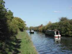
Whilst I was heading eastwards out of Leamington I approached a bridge to see smoke emerging from the other side. When I got to the other side I saw a young lady holding a rope on the towpath, keeping a boat into the side. Coming out of the boat at both ends was a plume of acrid smoke. A man emerged from the boat to proclaim that the engine was smoking and he could not switch it off - he had turned the switch and removed the key but still the engine was smoking away. I am mechanically dyslexic so after enquiring if they wanted any other help I bid them a good day and continued on.
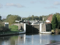
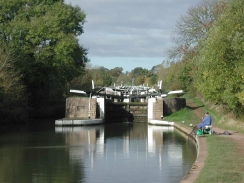
The Hatton Flight was as spectacular as I remembered it from the time I walked along here in 1995, and I enjoyed seeing it once again. One of the pounds between two of the locks was drained, showing the muddy bottom and even a rotting old boat hulk buried in the mud in the entrance to the narrow lock. Apparently it should not have been empty and had been full the previous night, so it appears that someone left both of the sluice gates open on the lower lock. Unfortunately I believe that it would take quite a while to fill up the lock and pound from the locks above it, as there is a large volume of water held in them.
I had to leave the canal at Shrewley as the towpath rose up to avoid the tunnel. Eventually the towpath meets a road in the village, and I used this opportunity to nip into a shop a few yards to the left and bought myself a bottle of water, a sausage roll and two chocolate bars which came in handy. After I left the shop I rejoined the towpath which descends down to the canal by means of the remarkable horse tunnel - the only one of these that I have ever seen.
I was starting to feel a bit tired after about thirteen miles, so I stopped off at the canal-side Black Boy pub near Heronfield for a quick drink. I had a nice pint of Tiger bitter followed by a pint of iced water, and it happened to be just what the doctor ordered. I also took off my left boot so that I could remove a stone that had been annoying me and I turned my sock around so the seams were sitting in a different place and would not rub. This stop really worked, and I felt better after the stop that I did before it.
I had not done much research prior to setting off on this walk as to where I could catch public transport back to Leamington Spa. When I parked at Leamington Spa I phoned up the National Rail Enquiries line and asked for train times back from Olton to Leamington Spa. I spelt out O-L-T-O-N, and she said there was one leaving at 15.30 which would take three hours to get there, changing at Aldershot and Guildford. I knew that Aldershot was down south (Hampshire, actually), and so I queried this. The lady on the phone repeated this so I decided to ignore the advice. Since I still did not know train times back to Leamington, I decided to nip into the station at Hatton (which is right by the canal) to look at the train times there. This told me that regular trains stopped on Sundays at Solihull station, so I decided to end my walk there.
There were literally scores of fishermen along he stretch of canal from Rowington to Kingswood. I reckon that there must have been at least one hundred, and I was fairly amazed when I saw a woman fishing - the only one that I an recall having seen on the whole way from London.
I now only have nine miles to walk along the Grand Union canal to reach the centre of Birmingham. With the journey from Solihull Station to the canal this increases to about eleven. For this reason I may actually walk past Gas Street Basin (the end of the canal) and walk for a few miles out towards Wolverhampton along another canal from the Basin.
Directions
This walk starts at the railway station in Leamington Spa. Leave the station and head through the car park until the A425 Old Warwick Road is reached. Turn left down the A425 for a short distance to the junction with the B4087 road. Turn right down this road and the canal is a few yards to the south, with the steps down being on the left-hand side of the road. The towpath follows the northern side of the canal for the first stretch of this walk.
Descend the steps and join the canal. Turn right to head westwards through Leaminton Spa, skirting to the southern side of the A425 road at a slightly lower level. The canal passes under a couple of road bridges before passing over a railway line and then the River Leam by an aqueduct.
The canal then passes from Leamington Spa to Warwick. It passes westwards through Warwick for a couple of miles past the Cape bottom and top locks to Budbrooke Junction, where an arm of the canal that went into Warwick left the canal. Shortly after this the first (lower) of the hatton flight of locks is reached. Over the next few miles the canal rises up the hill. At Hatton Lock No. 35 the towpath uses a bridge to swap over to the other, southern, side of the canal.
The canal continues rising to the top of the flight of locks. From here the towpath continues for about a mile to Hatton Station Bridge, where Hatton Station is a few yards to the south adjacent to the canal. From the station the canal continues northwestwards for a mile, to the south-eastern portal of Shrewley Tunnel.
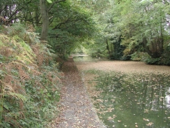
The towpath leaves the canal at the tunnel and rises up via a track to meet a minor road in the village. The towpath crosses straight across the road and starts to descend back down to the canal. Halfway down it enters the interesting (but dark) horse tunnel before emerging above the canal tunnel's northwestern portal. It then descends down to meet the canal in a leafy cutting.
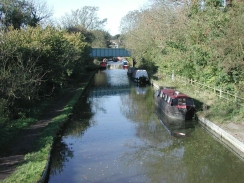
A pretty stretch of the canal then follows as it winds around northwestwards to Rowington and then Turner's Green. About a mile north of here Kingswood Junction is reached with a short spur canal that leads to the Stratford-upon-Avon canal. It then starts to head northwards, passing under Kingswood Bridge before coming to a long one and a half kilometre long straight.
At the end of the straight the canal makes a slight turn before passing Chessetts Wood and Heronfield House. At Heronfield there is a nice canal-side pub, the Black Boy, where it is possible to sit out and watch boats pass.
A kilometre on from the pub the bottom of the Knowle flight of locks is reached. After the top of the four locks is reached the canal passes under the B4101 and continues northwards for two kilometres to the bridge that carries the canal under the M42 motorway. The noise of the motorway dominates this whole area, but it is only visible for a short distance. The canal continues northwards for about a kilometre and a half to the Catherine de Barnes bridge before it turns around to head westwards for another kilometre and a half to Elmdon bridge.
Leave the canal at Elmdon Bridge and turn left down Damson Parkway road. When the A4141 Solihull Bypass is reached cross over and head south down the B1042 Hampton Lane for a short distance. At the end of this road turn half-right to head southwestwards along New Road to St Elphege Church. At the church (by a place called 'The Square') turn right and head through the pedestrianised High Street, which has many shops along it. When the High Street ends at a T-junction turn left down Station Road and follow it to a roundabout. Take the second-left exit from the roundabout and head down the B4102 for about fifty yards, and the station can be found along Station Approach to the right.
Further information
|
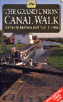
The walk is also covered in detail in the Grand Union Canal Walk, by Anthony Burton and Neil Curtis, ISBN 1 85410 244 3, published by Aurum Press Ltd. Click on the image to the right to go the Amazon page for this book.
For more details on the Grand Union Canal see Jim Shead's canal pages. |
|
Distances
| From | To | Distance (m) | Ascent (ft) | Descent (ft) |
|---|---|---|---|---|
| Leamington Spa Station | Hatton Top Lock | 5.8 | 266 | 121 |
| Hatton Top Lock | Knowle Top Lock | 8.8 | 404 | 348 |
| Knowle Top Lock | Elmdon Heath | 4.3 | 197 | 174 |
| Elmdon Heath | Solihull Station | 2.0 | 56 | 43 |
This makes a total distance of 20.9 miles, with 923 feet of ascent and 686 feet of descent.
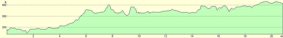
For more information on profiles, ascents and descents, see this page
Transport
There are regular train services from Solihull to Leamington Spa, although these are slightly less regular on Sundays. These trains are them service between Birmingham and London Marylebone.
Disclaimer
Please note that I take no responsibility for anything that may happen when following these directions. If you intend to follow this route, then please use the relevant maps and check the route out before you go out. As always when walking, use common sense and you should be fine.
If you find any information on any of these routes that is inaccurate, or you wish to add anything, then please email me.
All images on this site are © of the author. Any reproduction, retransmissions, or republication of all or part of any document found on this site is expressly prohibited, unless the author has explicitly granted its prior written consent to so reproduce, retransmit, or republish the material. All other rights reserved.
Although this site includes links providing convenient direct access to other Internet sites, I do not endorse, approve, certify or make warranties or representations as to the accuracy of the information on these sites.
And finally, enjoy your walking!
This walk was mentioned in the following routes:
| Grand Union Canal Walk |
Nearby walks
| # | Title | Walk length (miles) |
|---|---|---|
| 162 | Braunston to Leamington Spa | 16.6 |
| 166 | Solihull to Birmingham | 12.1 |
| 622 | Lower Quinton to Buckley Green | 22.2 |
|
|

|