Walk #165: Cley-next-the-Sea to Cromer
 |
 |
|
General Data
| Date Walked | 10/11/2001 |
| County | Norfolk |
| Start Location | Cley-next-the-Sea bus stop |
| End Location | Cromer bus station |
| Start time | 10.15 |
| End time | 15.14 |
| Distance | 13.1 miles |
| Description | This was a nice and varied walk, taking in shingle beaches, airy cliff tops and dark woodland complete with Roman camps. It also took in the county top of Norfolk, which is another one crossed off my list. |
| Pack | Today I carried a 30-litre daysack containing coat, trainers, digital camera and a spare top. |
| Condition | I feel fine after this walk, with no major trouble to report. My feet are absolutely fine despite getting a pebble in them. I was getting slightly tired towards then end, but with a little rest I could easily have walked on further if daylight had allowed. My legs and back are also okay with ni signs of any stiffness or aching. |
| Weather | The weather today was quite nice, with mostly sunny skies with a little cloud cover and no sign of any rain. It was fairly cold at times, particularly early on when I had to walk with my balaclava and gloves on, and the wind could be biting at times. |
| OS map | Landranger number 133 (North East Norfolk, Cromer & Wroxham) |
 |
 |
|
Map of the walk
Maps courtesy of Google Maps. Route for indicative purposes only, and may have been plotted after the walk. Please let me have comments on what you think of this new format. For a detailed table of timings for this walk, please see the table file.
 |
Notes
This was a lovely and varied walk, taking in coastal, cliff top and woodland walking. The weather was also very nice for such a walk, with the relatively cold temperature meaning that I did not need to drink any of the water that I was carrying.
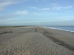
The minor road that runs north from Cley-next-the-Sea to Cley Eye was very muddy, and was flooded near the end. A sign at the start said "road liable to flooding", and someone had added one saying "last in 1997",which I thought was quite amusing. Once I had climbed up onto the shingle bank at Cley Eye I was faced with a gaggle of bird watchers, all with expensive cameras and / or telescopes looking out to sea.
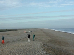
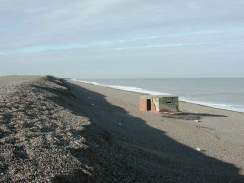
The shingle beach was quite enjoyable to walk along, although it was fairly tough in places (indeed it was worse in some ways than walking on sand). After Kelling I dropped down off the bank and onto the shingle beach, where I could see literally thousands of starfish littering the tide line. I had not seen many starfish before, and so seeing so many was quite something. Two days earlier there had been some large storms that had lashed the coast and the starfish were obvious casualties of these. Another casualty was the shingle bank itself, which had been eroded quite severely near Salthouse and the top was only a couple of feet wide.
For the second Saturday in a row I came near to losing my GPS. When I got off the bus at Cley-next-the-Sea I started my GPS so that I could write down my position. When I looked down for it it was far lower down my body than usual as the cord that loops around my neck had come undone at one end. I was very fortunate that this happened before the walk rather than during it, but I still have no idea how it happened when the knots had been trouble-free for two years.
I stopped for a break in Sheringham, choosing to have a quick pint of Abbott Ale in The Crown pub. Because I was slightly muddy and the pub was fairly full I decided to sit outside in the sunshine. Whilst I was drinking the pint an elderly couple came out of the pub, supported by another couple. While they were waiting for their car to be bought round to the front of the pub the elderly lady started talking to me, and she made my day when she said "You'll be a real terror when you leave school". I tried to explain to her that this whiskered person sitting in front of her was actually twenty-eight, but she would have none of it.
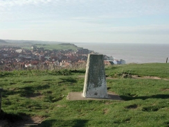
An unexpected highlight of today was going past a trig point on a hill just to the east of Sheringham. This trig point was quite nicely situated on the cliffs above the town, so there were nice views available over the town, over the sea, and towards Beacon Hill. The Trig Point was marked BM S5279 and provided another couple of photos for my collection.
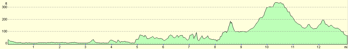
One of the aims for today was to reach Norfolk's highest point, which is at Beacon Hill, a couple of kilometres inland from the sea between Sheringham and Cromer. This is the second-lowest county top in Britain, reaching only 102 metres (336 feet) above sea level. The only other county top that is lower than this is the old county of Huntingdonshire, which only reached 80 metres above sea level. The actual top was marked by a large transmission mast that made it a very prominent landmark. The whole area around is heavily wooded with broadleaved trees giving it a lovely atmosphere. Beacon Hill was the site of a Roman Camp, and as I descended I could almost sense the spirits of people past.
When I got to Cromer I initially passed the railway station, so I nipped in to check the times of trains heading back to Sheringham. Unfortunately the next train was not due for eighty-five minutes, so I walked to the bus station where fortunately one was due in half-an-hour. Instead of waiting outside at the bus station (which for some reason had no seats which seems slightly ludicrous) I went across the road to a caf� and had a bacon and sausage sandwich and watched the antics of an old lady repeatedly losing her bus ticket.
I parked my car at the railway station car park in Sheringham, which is conveniently adjacent to the main bus stops in the town (calling it a bus station gives it a grandeur that it does not really deserve). This station is beside the North Norfolk Railway's station, which is situated in the original Sheringham railway station (the BR station being across the adjacent road). The station looked quite nice and I will have to visit again to have a ride on the railway sometime.
Directions
This walk starts at the bus stop just to the east of Cley-next-the-Sea on the A149 at TG048442, where the Beach Road comes south from Cley Eye. Leave the A149 and head north up the narrow road for about a mile to the car park at Cley Eye. From here, it follows the Peddars Way and Norfolk Coast Path for the rest of the day.
At the car park at Cley Eye climb up to the top of the shingle bank and turn right. Progress in a north-southeasterly direction along the shingle beach which runs between the sea to the left and a nature reserve on the right.
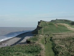
After a few miles the car park at Weybourne Hope becomes visible. Here the walk along the shingle beach ends and the path starts to climb up to the top of the cliffs. Follow the cliffs as they head eastwards from Weybourne Hope, passing just to the southern (inland) side of an old customs house. The path then continues on for another couple of miles, passing a golf course as it ascends to a little hut that is a coastguard lookout post. The path then meets the Esplanade before descending down onto the Promenade in Sheringham.
Follow the North Norfolk Coast Path National Trail signs along the roads of Sheringham until the eastern side of the town is reached. Ascend some steps and then turn left to climb up a hill to a Trig point, from where lovely views can be seen over the sea to the north and Sheringham to the west. In the distance to the southeast can be seen a large mast, which is situated on Beacon Hill, the highest point in Norfolk.
Descend from the Trig point to the southeast, heading across a field for where a track (known as Nelson Road) and the railway line cross. Cross the railway line and then follow the track to where it meets the A149 road. Cross over the A149 and take a lane opposite which heads eastwards for a short distance before turning south to pass a school. The path then starts to climb a slight hill towards a tree line.
When the tree line is reached turn left to head east along a track for a short distance. After about a hundred yards take a path that heads off to the right, to climb up through the trees. This then becomes a track, which passes a car park before ending at a T-junction with a minor road.
Cross over this road and follow a track on the opposite side for about fifty yards. To the right can clearly be seen the base of the mast at the top of Beacon Hill, which is Norfolk's highest point. Just before the mast is a rough track that descends to the north. Follow this track as it starts to swing around to the east. When it starts to turn around to head north again continue straight on along an obvious footpath. When this ends at another track turn left down the track and then almost immediately right again to join an elegant tree-lined footpath.
When this footpath ends at another track continue straight on and follow it as it crosses a minor road. Head under a quite elegant brick railway bridge and continue on up to the top of Stone Hill along Newstead's Lane. From here the track descends to the northeast to meet a minor road. Cross over this road and almost immediately is Sandy Lane. To the left is a bridge over the railway, but this route follows the Sandy Lane to the right, which heads east to the south of the railway. After a few hundred yards this road ends at the A148. Turn left down the A148 and follow it for a short distance until you see the railway station on the left.
To get to the bus station continue on past the station and the supermarket to the next road junction. Turn left and head up this road for a short distance. Take the first road to the right, which heads along the northern side of a car park as it descends to the bus station and tourist information point.
Distances
| From | To | Distance (m) | Ascent (ft) | Descent (ft) |
|---|---|---|---|---|
| Cley-next-the-Sea | Sheringham | 8.0 | 525 | 522 |
| Sheringham | Cromer | 5.1 | 597 | 564 |
This makes a total distance of 13.1 miles, with 1122 feet of ascent and 1086 feet of descent.
For more information on profiles, ascents and descents, see this page
Transport
Cley-next-the-See is served by the Norfolk Coast Coasthopper Service 36, which is run by Norfolk Green Coaches and runs from Sheringham to Hunstanton. This service runs roughly every two hours during winter and more frequently during summer.
There is a choice of transport between Cromer and Sheringham; trains run between the two towns, calling at West Runton on the way, and First East Counties Number 50 bus service also runs between the two.
Disclaimer
Please note that I take no responsibility for anything that may happen when following these directions. If you intend to follow this route, then please use the relevant maps and check the route out before you go out. As always when walking, use common sense and you should be fine.
If you find any information on any of these routes that is inaccurate, or you wish to add anything, then please email me.
All images on this site are © of the author. Any reproduction, retransmissions, or republication of all or part of any document found on this site is expressly prohibited, unless the author has explicitly granted its prior written consent to so reproduce, retransmit, or republish the material. All other rights reserved.
Although this site includes links providing convenient direct access to other Internet sites, I do not endorse, approve, certify or make warranties or representations as to the accuracy of the information on these sites.
And finally, enjoy your walking!
This walk was mentioned in the following routes:
| A walk around East Anglia |
| Peddars Way and Norfolk Coast Path |
Nearby walks
| # | Title | Walk length (miles) |
|---|---|---|
| 160 | Wells-Next-The-Sea to Cley-next-the-Sea | 11.1 |
| 168 | Cromer to North Walsham via Mundesley | 12.8 |
| 255 | Wells-next-the-Sea to Sheringham | 19.8 |
|
|

|