Walk #166: Solihull to Birmingham
 |
 |
|
General Data
| Date Walked | 11/11/2001 |
| County | West Midlands |
| Start Location | Solihull Station |
| End Location | Birmingham (New Street) |
| Start time | 08.58 |
| End time | 13.45 |
| Distance | 12.1 miles |
| Description | This was a fairly boring walk into the centre of Birmingham from Solihull. It was mainly a walk along he towpath of the Grand Union Canal, but there was also some road walking from the railway station in Solihull to the canal and from Gas Street Basin in the centre of Birmingham to New Street Station. |
| Pack | I carried a 30-litre daysack containing coat, trainers, digital camera and a spare top. |
| Condition | I feel okay after this walk, although slightly fatigued. I have no new blisters on my feet, and my legs feel fine, as do my back and shoulders. I had a slight twinge from my ankle whilst walking on the gravel surface on the ascent of the Farers Bridge Lock flight. |
| Weather | The weather today was changeable, with periods of sunshine being spoiled by periods of heavy cloud. For about an hour there was a bit of drizzle in the air which caused my fleece to get damp, but fortunately there was nothing heavy enough for me to require putting my coat on. |
| OS map | Landranger number 139 (Birmingham & Wolverhampton) |
 |
 |
|
 |
 |
|
Map of the walk
Maps courtesy of Google Maps. Route for indicative purposes only, and may have been plotted after the walk. Please let me have comments on what you think of this new format. For a detailed table of timings for this walk, please see the table file.
Notes
This was an excellent day, if only because I have now walked the entire way from London to Birmingham along the Grand Union Canal, which was one of my targets for this year. It has also set me up well to be able to head northwards from here to Doveridge and westwards to Wolverhampton and then Bridgnorth, the latter of which means that the Welsh border is within striking distance.
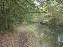
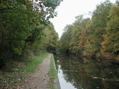
I saw no boats moving along the canal until I got to the very centre of Birmingham. This was a dramatic difference to the last few days walking along the canal, where there had been many boats moving about. Indeed in places the surface of the canal was covered in a layer of thin green slime and fallen leaves, showing that the surface had not been disturbed for some time and making the canal look slightly uncared for.
The approach to the centre of the city was very dinghy, and seemed a marked contrast to the canal in the centre of London. Perhaps it was the slightly dismal weather and the windblown leaves strewn everywhere which made a difference, for when I walked in the opposite direction in the summer of 1995 I cannot remember having had that impression.
All the locks on today's walk were narrow locks, whereas all the others on the canal from London has been broad locks. The thirteen locks of the Farmers Bridge flight were quite close together and would have made some good photographs if it was not for the slightly dreary setting. Indeed a large concrete building is built directly over one of the locks, which looked quite incongruous and totally spoiled the flight.
The towpath for a few miles south of Solihull was very muddy, with a layer of leaves disguising the thick oozing mud that lay underneath. Fortunately the towpath soon changed to a much firmer surface of loose gravel and then brick. For much of the distance the canal runs in a shallow cutting with trees growing above, which explained all the leaves everywhere and made the towpath slightly dark and forbidding on a dark cloudy day. Once the cutting ended the canal entered the inudstrialised outskirts of the city, and hence swapped one kind of gloom for a totally different kind.
Navigation through Birmingham was slightly difficult because there are many canal junctions arranged in a slightly confusing order. Fortunately there were cast iron signs at the junctions showing directions, and although they did not always mention Gas Street Basin they helped me orientate myself so that I could head in the right direction.
Directions
This walk starts at Solihull Station, the first part of the walk involves getting from the station to the canal at the place that I stopped the last walk along the canal.
Leave the station and turn right to head down Station Approach to meet the B40142. Cross the road and then turn left and continue for about fifty yards to a roundabout. Take the second-right exit and head down Station Road for a short distance. When the pedestrianised High Street comes in from the right turn right and had east down it. When St Elphege Church is met at The Square turn left and head up New Road. WHen this road ends at a T-junction turn right and then almost immediately left to had up the B1042 Hampton Lane for a short distance. When this road ends at the A4141 Solihull Bypass cross over and head up Damson Parkway. The bridge carrying the road over the canal is just under a kilometre to the north along this road. Cross over to the north side of the bridge and take a little path that leads down to the left to meet the canal towpath.
The canal starts to head northwestwards through the outskirts of the city, passing beneath a motor works before getting near to the station at Olton.
The flight of locks at Camp Hill are unusual on the canal - they are narrow instead of the broad locks used on the rest of the canal. Just above the locks is a large basin that must have been used for transhipment of goods from broad to narrow boas if they were to go into the centre of Birmingham.
At Bordersley Junction do not turn right but cross over the bridge that carries the towpath over the canal and head down the canal which leads slightly off to the left. The canal to the right is the Birmingham and Warwick Canal; the one that we are following to the left is the Digbeth Branch.
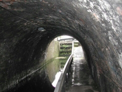
The six Ashteed Locks are then reached; halfway up the flight there is the low Ashted Tunnel which was quite intriguing as towpaths through tunnels are quite rare. After the locks Aston Junction is reached. Turn left at this junction and pass under the long set of railway arches on the approaches to Snow Hill Station. These bridges were so wide it reopened an old argument in my head - when is a bridge a bridge and not a tunnel?
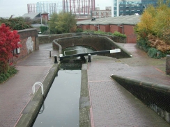
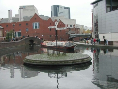
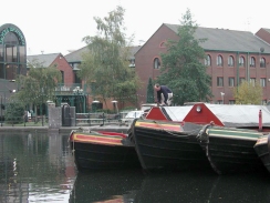
After the bridge the canal starts to rise by means of the thirteen locks of the Farmers Bridge flight. At one stage there is a lock directly underneath a large concrete building - an ugly setting for a canal. At the top of the flight Cambrian Wharf is reached, and the National Indoor Arena dominates the view. At the next junction, Farmers Bridge Junction, turn left over one of the iron bridges and head down either side of the canal for a short distance until Gas Street Basin appears on the left. Walk around the basin and have a look at the boats that are arrayed there.
From Gas Street Basin follow the towpath on the right-hand (eastern) side of the canal north halfway towards Farmers Bridge Junction. On the right is a large building, the International Convention Centre (the ICC), which is part of the NEC group of companies and is one of Europe's leading conference facilities, with eleven main halls and ten executive meeting rooms. During the day the public are allowed to use this building as a through route, so turn right and walk straight through the building.
When you emerge from the other side of the ICC, head straight on to the east across Centenary Square until you reach the A4400 Suffolk Street. Cross over this and follow the obvious route across to the Town Hall and Victoria Square. In Victoria Square turn half-right to reach New Street. Follow New Street eastwards and then follow the obvious signs pointing towards New Street Station.
Further information
|
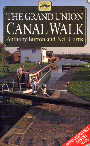
The walk is also covered in detail in the Grand Union Canal Walk, by Anthony Burton and Neil Curtis, ISBN 1 85410 244 3, published by Aurum Press Ltd. Click on the image to the right to go the Amazon page for this book.
For more details on the Grand Union Canal see Jim Shead's canal pages. |
|
Distances
| From | To | Distance (m) | Ascent (ft) | Descent (ft) |
|---|---|---|---|---|
| Solihull Station | Elmdon Heath | 2.0 | 43 | 56 |
| Elmdon Heath | Bordersley Junction | 6.6 | 226 | 282 |
| Bordersley Junction | Birmingham New Street | 3.5 | 174 | 131 |
This makes a total distance of 12.1 miles, with 443 feet of ascent and 469 feet of descent.
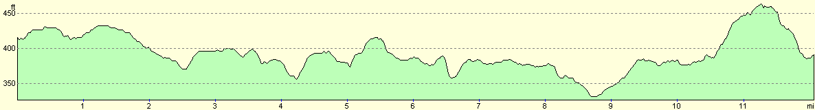
For more information on profiles, ascents and descents, see this page
Transport
There are regular trains sverices running from Birmungham New Street and Moor Street stations back to Solihull. On Sundays Solihull is the first stop, but on other days the trains also call at intermediate stations such as Olton which is next to the canal.
Disclaimer
Please note that I take no responsibility for anything that may happen when following these directions. If you intend to follow this route, then please use the relevant maps and check the route out before you go out. As always when walking, use common sense and you should be fine.
If you find any information on any of these routes that is inaccurate, or you wish to add anything, then please email me.
All images on this site are © of the author. Any reproduction, retransmissions, or republication of all or part of any document found on this site is expressly prohibited, unless the author has explicitly granted its prior written consent to so reproduce, retransmit, or republish the material. All other rights reserved.
Although this site includes links providing convenient direct access to other Internet sites, I do not endorse, approve, certify or make warranties or representations as to the accuracy of the information on these sites.
And finally, enjoy your walking!
This walk was mentioned in the following routes:
| Grand Union Canal Walk |
Nearby walks
| # | Title | Walk length (miles) |
|---|---|---|
| 164 | Royal Leamington Spa to Solihull | 20.9 |
| 170 | Birmingham to Wolverhampton | 14.7 |
|
|

|