Walk #170: Birmingham to Wolverhampton
 |
 |
|
General Data
| Date Walked | 15/12/2001 |
| County | West Midlands |
| Start Location | Birmingham (New Street) |
| End Location | Wolverhampton (St Georges) |
| Start time | 09.40 |
| End time | 15.50 |
| Distance | 14.7 miles |
| Description | This was a nice walk along the canal |
| Pack | I carried a 30-litre daysack containing coat, trainers, digital camera and a spare top. |
| Condition | I am relatively okay after this walk, although I am slightly more fatigued than I would normally be after a walk of this distance. The ball of my left foot has a hot spot on it, which was probably due to using an old (and worn) pair of outer socks instead of my newer, thicker ones. Aside from that everything else is fine. |
| Weather | It was a nice day today, with a small enough amount of cloud in the sky to make any serious threat of rain unlikely. It was also fairly cold, with the thin layer of ice on the canal not being melted by the sun which hung low in the sky all day. Fortunately there was not any wind to chill me, so it was an ideal winter's day for walking. |
| OS map | Landranger number 139 (Birmingham & Wolverhampton) |
 |
 |
|
Map of the walk
Maps courtesy of Google Maps. Route for indicative purposes only, and may have been plotted after the walk. Please let me have comments on what you think of this new format. For a detailed table of timings for this walk, please see the table file.
 |
 |
|
Notes
The main aim of this walk was to act as a positioning walk, so that next year I can progress westwards from Birmingham towards Aberwyswyth on the west coast of Wales. Because this walk was right through the middle of the West Midlands conurbation it was not a particularly scenic journey, but the fact that it was a canal walk offset much of this, and there were plenty of interesting things to be seen throughout the trip.
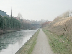
The early part of the walk was along the New Main Line, which is in a 22-metre deep cutting and avoids the locks which were a feature of the Old Main Line. The New Main Line was constructed by Telford between 1827 and 1829, and bypassed Brindley's (1768-69) and Smeaton's (1790) summit levels. The New Main Line was 26 kilometres long, which is far shorter then the original 37 kilometre length of Brindley's canal. The main reason why this massive amount of work had to be undertaken was that the canal was extremely busy; apparently the over-usage of the canal was causing severe congestion. On the walk up from Gas Street Basin there were many signs stating that the Old Main Line was shut for motorway maintenance works, so I took the New Main Line, which was a much more direct route anyway.
The New Main Line had some lovely bridges crossing it whilst it was in the cutting, including Galton Bridge, a beautiful iron aqueduct designed by Telford that gracefully spanned the 150-foot wide cutting. The previous journey along the canal from Solihull to Birmingham had been a much less enjoyable walk than this one, with a much greater sense of desolation and urban decay. Perhaps it was because I we heading away from the conurbation rater than towards it, but the canal seemed much more attractive on this walk.
In the middle of the journey some ariels on a hillside to my left were visible. These ariels mark the highest point of the West Midlands, Turner's Hill, which I will have to visit soon so that I can mark off that county top as part of my county top walk. Having got this near them will make that task so much easier.
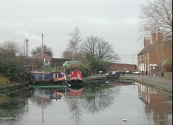
I stopped for a quick pint of Banks's Bitter at the "Barge and Barrel", a pub at Tipton Factory Junction. Unfortunately they did not sell any crisps, so I had to make do with a Kit-kat to soak up the beer.
The network of canals near Birmingham is very complex, and the early part of the walk had branches going off it very regularly. It is an old saying that Birmingham has more miles of canals than Venice, and I can believe it after this walk. The Birmingham Canal Navigations was once a network of 160 miles of canals, of which about 100 are still navigable today. The number and variety of branches and loops off the canal had to be seen to be believed - it is hard to believe that all these cuts were dug with nothing more than manpower.
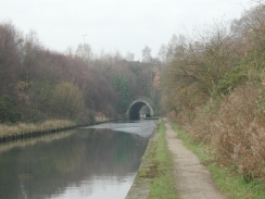
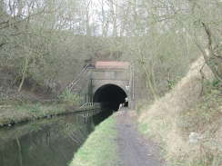
The 330-metre long Coseley Tunnel was very impressive - it was the first canal tunnel of any substance that I have walked through as it has towpaths through it on both sides! It was very dark and wet inside, and some of the stones on the towpath were a bit slippy, particularly in the wet stretches.
When I got to Wolverhampton I went into town to do some christmas shopping. Although the walk finished near the railway station, I decided to get the West Midlands Metro back to Birmingham, which took longer but gave me a journey on this tram system.
For more details of the history of the Birmingham Canal Navigations, see the roots and routes site, which has some excellent background detail on the (slightly confusing) way the canals evolved.
Now that I have reached Wolverhampton there are two walks that can be done; one northwards to Cannock (to eventually meet up with my Land's End to John O'Groats walk at Doveridge in southern Derbyshire), and one westwards to Bridgnorth (as part of my walk to Aberwyswyth).
Directions
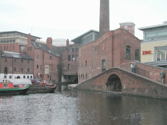
This walk starts off at Birmingham New Street Station, right in the centre of the city. Leave the station and head westwards along New Street through the city. Follow signs west towards the International Conference Centre (ICC), crossing the A4400 Suffolk Street in the process by means of a wide path. Just before the ICC is reached turn slightly left and follow signs to Gas Street Basin.
When you reach Gas Street Basin walk down the left-hand (southern) side of the basin and cross over a bridge at the far side of the basin. Turn right and head north up a canal past the International Conference Centre to another bridge over another canal below the National Indoor Arena. Cross over this bridge to reach the northern towpath of the Birmingham Canal Network New Main Line.
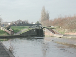
Turn left and follow the Main Line as it heads northwestwards through the city. There are many branch canals off the main line of the canal; the route follows the very wide main line all the way to Wolverhampton. In the process it passes through Smethwick, Sandwell and Tipton before reaching the only locks on the canal, the flight of three Tipton Factory locks. There then follows more canal junctions and the long Coseley Tunnel, which has a towpath through it and therefore can be walked through.
At this point the canal turns to head north-northwestwards through the outskirts of the city into the suburbs of Wolverhampton. Continue onwards until the top lock of the long Wolverhampton flight is reached; here turn right to leave the canal and join the A4124 Wednesfield Road. Turn right and follow the A4124 as it heads across a bridge over the canal to meet the A4150 Ring Road. Cross the ring road and then follow signs towards St Georges Metro Station in the centre of the city.
For more details on this walk see the British Waterways website and Jim Shead's canal pages.
Distances
| From | To | Distance (m) | Ascent (ft) | Descent (ft) |
|---|---|---|---|---|
| Birmingham New Street | Tipton Factory Junction | 9.1 | 456 | 381 |
| Tipton Factory Junction | Wolverhampton | 5.6 | 213 | 177 |
This makes a total distance of 14.7 miles, with 669 feet of ascent and 558 feet of descent.
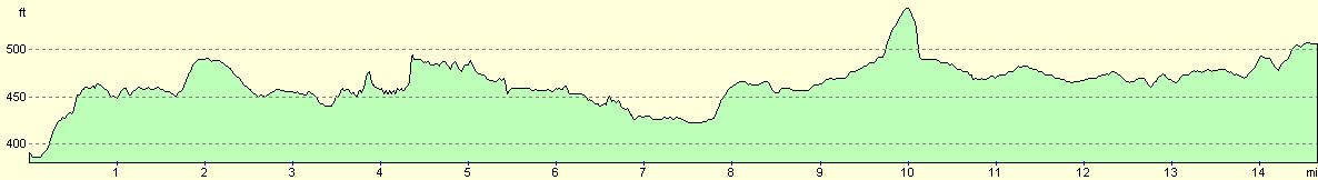
For more information on profiles, ascents and descents, see this page
Transport
I parked at Solihull station and caught a train into Birmingham Moor Street Station, from where I walked to New Street. On the way back I used the West Midlands Metro that runs from Wolverhampton to Birmingham Snow Hill, but there are also regular (and quicker) train services between the two stations.
Disclaimer
Please note that I take no responsibility for anything that may happen when following these directions. If you intend to follow this route, then please use the relevant maps and check the route out before you go out. As always when walking, use common sense and you should be fine.
If you find any information on any of these routes that is inaccurate, or you wish to add anything, then please email me.
All images on this site are © of the author. Any reproduction, retransmissions, or republication of all or part of any document found on this site is expressly prohibited, unless the author has explicitly granted its prior written consent to so reproduce, retransmit, or republish the material. All other rights reserved.
Although this site includes links providing convenient direct access to other Internet sites, I do not endorse, approve, certify or make warranties or representations as to the accuracy of the information on these sites.
And finally, enjoy your walking!
Nearby walks
| # | Title | Walk length (miles) |
|---|---|---|
| 166 | Solihull to Birmingham | 12.1 |
|
|

|