Walk #171: Doveridge to Abbots Bromley
 |
 |
|
General Data
| Date Walked | 26/12/2001 |
| County | Derbyshire, Staffordshire |
| Start Location | Doveridge |
| End Location | Abbots Bromley |
| Start time | 10.10 |
| End time | 14.08 |
| Distance | 9.7 miles |
| Description | This was a lovely walk, mainly following the Staffordshire Way, westwards from Doveridge to Uttoxeter and then southwards to Abbots Bromley. |
| Pack | I carried a 30-litre daysack containing spare clothing, books and a few books. |
| Condition | I feel fine after this walk, and I have had no trouble with any part of my body. My chest, which has been giving mr pain for over a month, gave me a little gip but nothing too serious. I have no blisters either, which is a relief as I am planning to do some more walking over the next few days. |
| Weather | The weather today was quite cold, as is to be expected at this time of year. There was a strong wind which made me feel slightly chilly whenever I was in an exposed place. Later on it started to cloud over, and as I walked along the road into Abbots Bromley it started to snow, which was really nice. |
| OS map | Landranger number 128 (Derby & Burton upon Trent) |
 |
 |
|
Map of the walk
Maps courtesy of Google Maps. Route for indicative purposes only, and may have been plotted after the walk. Please let me have comments on what you think of this new format. For a detailed table of timings for this walk, please see the table file.
Notes
This is the first segment of a walk designed to connect Wolverhampton with Doveridge, thus creating a large circular walk via London. As it was done on Boxing Day after a fairly heavy night, I was not feeling 100%, so it was nice to do a nice and gentle walk to walk off the excesses of the night before.
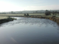
My family has lived in Doveridge since 1984, so I knew the first part of this walk to Uttoxeter very well. The highlight of this stretch was the elegant and graceful foot suspension bridge over the river Dove below the church in Doveridge. I have never been able to find out why this bridge was built, and it seems to be a very spectacular bridge for the little amount of traffic that it gets, particularly as the old stone Dove Bridge (which is now bypassed by two concrete structures carrying the A50) is only a little way further to the north.
I had to stop at the suspension bridge to change batteries in my walkman and my GPS, as both had simultaneously run out of power. Fortunately I had packed enough spare batteries to allow me to change both sets and still have enough spare to replace those in my camera if necessary.
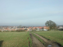
Before the station is reached you pass the entrance to Uttoxeter racecourse and a large building belonging to Elkes Biscuits, both of which are significant employers in the area. A litle further on as you cross the new bridge that carries one of Uttoxeter's many bypasses over the railway just to the west of the station, many large yellow machines become visible to the right. These are brand-new JCB diggers waiting delivery from the old Bamford agricultural machinery works in Uttoxeter.
On the way past a farm to the south of Uttoxeter I discovered an old abandoned, rusting JCB digger with one wheel missing lying forlornly in a field. It looked so decrepit that I took a photograph of it as it looked quite nice. I later found out from my brother-in-law that it belonged to his family (who own farms in the area), and that the engine still runs!
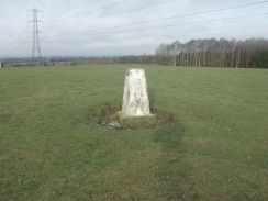
A nice find on the walk was the Trig point just to the southeast of Parkstile farm. This was marked with 'OS BM S4205', and a plaque stating that it had been adopted under the OS Trig Point adoption scheme.
Abbots Bromley is a very nice little town, and is famous around the world for an annual event called the 'Horn Dance'. This is a strange dance involving six men carrying wooden effigies of reindeer heads with real reindeer horns embedded in them, dancing for twenty miles around the villages surrounding Abbots Bromley. It is an ancient dance, traditionally held on the Monday following the first Sunday after September 4 (it was performed during harvesting on August 24th until 1752, when the change to the Julian calendar brought it forward). The present dance dates from about 1125 when the local foresters obtained the hunting rights in Needwood Forest from the Abbot of Bromley.
This walk ends opposite the Butter Cross in Abbots Bromley, which is one of the oldest buildings in the village. It is an old market cross dating back to the time of Richard III, and was probably built in 1339. It is quite an attractive little building, and it leads me to wonder what events it has seen over such a long span of years.
The next stage of the walk will be to reach the Trent and Mersey canal at Rugeley, which will allow me to reach Stoke-on-Trent and then further north towards Manchester if I so desire. It will also allow me to get to Cannock and then Wolverhampton, which will link it with the Grand Union Canal walk from Birmingham.
Directions
This walk starts off opposite the manor house (beside the primary school) in the village of Doveridge, two miles to the east of Uttoxeter.
Turn left to head south down the road for a short distance, to the point where Bell Lane comes in from the east, beside the manor house. Turn right down a footpath that heads westwards past a new housing estate down to a little plank bridge over a stream. Continue along the footpath as it rises between two fences up to meet a road in another housing estate.
Head straight across the road to an offset stile that leads on to another footpath which heads westwards to the end of Pump Lane. Cross this road and take another stile that leads downhill across a field to Lower Street.
Cross Lower Street and take another footpath that heads westwards across some fields at the top edge of the floodplain of the river Dove. When this footpath meets Mill Lane beside the graveyard of Doveridge church continue along the lane for a short distance and then take another footpath that leads off to the left opposite the gate that leads into the graveyard.
This footpath leads along a raised bank, crossing a concrete slab that carries the path over the old mill stream. A short distance further on from this a lovely suspension bridge that carries the footpath over the River Dove is reached. Cross the bridge and take the footpath that leads northwestwards across the top of the raised banking until the A50(T) road is reached.
Turn left and walk west beside the A50(T) for about a hundred yards. Take the first stile reached to the left, which leads southwards across fields. This is now the Staffordshire Way, which will be followed for the rest of the journey. Aim for one of the towers holding up some electricity lines and when they are reached lead onwards to the now-obvious 'The Willows' farm. Pass to the right of the farm and then take another footpath that leads in a south-southwesterly direction until a large warehouse-style building with 'Elkes' written on it is reached. Join a broad track (part of the old Uttoxeter to Rocester railway line) and turn right down this to a gate. Turn left past the gate and follow signs to Uttoxeter station.
From the station enter the car park and walk west along Brookside Road beside the railway line for a short distance until a large road bridge is reached. Turn right and walk to join Bridge Street that leads over the bridge. Turn left and cross the bridge carrying the road over the railway line and continue on until a roundabout is met.
Cross over the roundabout and head towards the road opposite. At the junction of the roundabout and the road there is a footpath leading up to the right, climbing up to the top of a high bank. Take this footpath as it climbs to the top of the bank, and then follow it as it turns to the left to head southwards up Balance Hill.
The footpath is easy to follow as it heads in a dead-straight line southwards as it climbs the hill, sometimes following roads, at other times green lanes or footpaths. Eventually Field Head Farm is reached, where some expansive views to the north can be obtained, with the JCB factory at Rocester visible in the distance and the Weaver Hills on the skyline. From Field Head Farm the path heads southwards to join a green lane, Timber Lane, that ends at the surfaced Cullamore Lane.
Cross Cullamore Lane and take a footpath opposite that heads south past Knightsfield Farm. The footpath leads across fields to Knightslands Farm before meeting another road. Turn right down this road and then after a short distance take another footpath that heads off to the left. This follows a field boundary before turning to the right to head southwards down to meet another lane.
Cross the lane and take another footpath that leads off on the other side of the lane. This footpath heads in a generally southerly direction past a farm to meet another toad. turn right down this road for a short distance until it bends to the right, at which point a farm track leads to the southeast to Marlpit House Farm. Pass the farm and continue along the track to the little house at Parkstile.
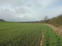
When the track bends around to the left to go to Parkstile continue straight on and head south across fields, passing below a Trig Point on the hillside to the left. The footpath then meets a track which it follows to the southwest for a shot distance to some trees. It then skirts the trees and at the far edge turns left to head southeastwards alongside a hedge. The footpath continues on in that direction for about a mile, crossing a track about halfway. When the hedge ends at a stream turn right to head westwards uphill to a corner of some woodland.
When the woodland is reached turn left to head southwestwards for a short distance down the hill. When a gate is reached turn right to head south-southwestwards across fields along a footpath, which meets Hobfield Lane end-on. After a couple of hundred yards this track ends at Woodmill Lane.
Here my route differs from the Staffordshire Way. Because it was snowing I chose to continue southwestwards along Woodmill Lane instead of following the Staffordshire Way across fields. Follow the road as it descended to meet Dunstal Brook (becoming Schoolhouse Lane in the process), before climbing up the other side of the valley. When the top of the little valley is reached houses start to appear, and another little descent along Schoolhouse Lane leads down to the Butter Cross in Abbots Bromley on the B5014 Bagot Street.
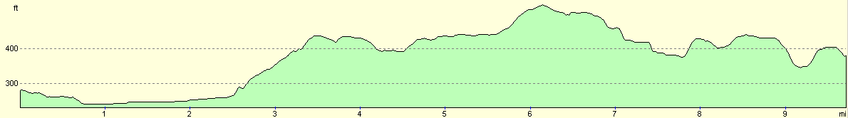
Distances
| From | To | Distance (m) | Ascent (ft) | Descent (ft) |
|---|---|---|---|---|
| Doveridge | Uttoxeter Station | 2.2 | 26 | 49 |
| Uttoxeter Station | Marlpit House Farm | 3.3 | 276 | 92 |
| Marlpit House Farm | Abbots Bromley | 4.2 | 259 | 322 |
This makes a total distance of 9.7 miles, with 561 feet of ascent and 463 feet of descent.
For more information on profiles, ascents and descents, see this page
Transport
I relied on my girlfriend to pick me up from Abbots Bromley and drive me back to Doveridge, which came in really handy. Aside from this there are regular bus services running from Uttoxeter to Burton, which call at Doveridge, and other services that run between Abbots Bromley and Uttoxeter.
Disclaimer
Please note that I take no responsibility for anything that may happen when following these directions. If you intend to follow this route, then please use the relevant maps and check the route out before you go out. As always when walking, use common sense and you should be fine.
If you find any information on any of these routes that is inaccurate, or you wish to add anything, then please email me.
All images on this site are © of the author. Any reproduction, retransmissions, or republication of all or part of any document found on this site is expressly prohibited, unless the author has explicitly granted its prior written consent to so reproduce, retransmit, or republish the material. All other rights reserved.
Although this site includes links providing convenient direct access to other Internet sites, I do not endorse, approve, certify or make warranties or representations as to the accuracy of the information on these sites.
And finally, enjoy your walking!
Nearby walks
| # | Title | Walk length (miles) |
|---|---|---|
| 68 | Willington to Doveridge | 12.6 |
| 69 | Doveridge to Thorpe | 14.9 |
| 569 | Abbots Bromley to Stafford via Rugeley. | 16.0 |
|
|

|