Walk #69: Doveridge to Thorpe
 |
 |
|
General Data
| Date Walked | 18/03/2000 |
| County | Derbyshire, Staffordshire |
| Start Location | Doveridge |
| End Location | Thorpe |
| Start time | 09.00 |
| End time | 15.15 |
| Distance | 14.9 miles |
| Description | An initial walk from Doveridge to the start of the Limestone Way at Rocester, and then along the Limestone Way past the village of Thorpe to my campsite near Fenny Bentley. |
| Pack | Full Pennine Way-spec kit. |
| Condition | Tired, but otherwise fine. No blisters of any note. |
| Weather | Initially 80% sun, 20% cloud, with the cloud level decreasing over time. Later on it became very warm for the time of the year. |
| OS map | Landranger number 128 (Derby & Burton upon Trent) and Outdoor Leisure number 24 (The Peak District - White Peak Area). There is about 2 miles between the A52 and Thorpe that are not covered in either of these maps, but are covered very well in the Limestone Way book. |
 |
Map of the walk
Maps courtesy of Google Maps. Route for indicative purposes only, and may have been plotted after the walk. Please let me have comments on what you think of this new format. For a detailed table of timings for this walk, please see the table file.
Notes
This was a very nice days walking, ending at a very nice campsite with good facilities. The going was fairly easy, with 3 or 4 miles of walking along the floodplain of the River Dove being followed by several miles of up-and-downing to cross the hills and enter the Peak District National Park.
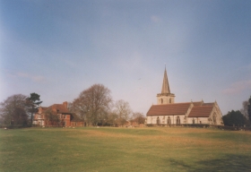
The scenery throughout this walk is nice, and very varied. During the initial leg of the walk to Rocester, the JCB plant and the Weaver Hills (to many people the real start of the Pennine Range of hills) are prominent to the north. Late on, as you pass Upper Mayfield, the hills of Dovedale rise in front of you.
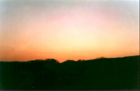
The weather was very fine throughout this walk, and it was unseasonably warm at 14 degrees Celsius. For the majority of the walk I was to hot, as I had my base layers on. The evening was finished off with drinks in a pub in Fenny Bentley and a beautiful orange sunset over Thorpe Cloud.
Directions
From the Post Office in Doveridge head north out of the village along Sand Lane, passing the village hall before reaching the roundabout with the old main road. turn left along the old main road (called Derby Road) until the Cavendish Arms is met on the left. When the road curves to the left past the pub continue straight on along another road for a few yards, and then turn to the right along Upwoods Road. This road heads northwards, crossing over the A50(T) on a bridge. When the road forks immediately over the bridge take the left fork down the hillside towards Eaton Hall Farm. At the top of the hill the public road ends and a public footpath continues on down to the farm and gun club. Pass through the farm and follow the Staffordshire Way along a track that reaches a T-junction with another track. Turn right along this track for a hundred yards towards Eaton Dovedale Farm. Just before the farm is reached turn left down another track that leads northeastwards towards the abandoned farm at Sedsall. When the track heads to the right uphill turn to the left, following the Staffordshire Way as it skirts to the left of the boarded-up farmhouse before skirting the base of the hillside northeastwards.
Continue on along the Staffordshire Way as it heads northwards near to the River Dove; at a loop in the river the way cuts straight across a school playing field near Abbotsholme School before rejoining the riverbank and following it northwards to Rocester Bridge. Climb up the steps to the road and then turn left to cross the bridge over the River Dove, and continue on past Arkwrights mill into the centre of Rocester
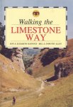
From Rocester follow the Limestone Way all the way to Thorpe. See 'Walking the Limestone Way', by R&E Haydock and B&D Allen, ISBN 0 907758 92 4, for more details, or click on the link below.
Head out of Rocester up fields to the B5030 road. Cross the road and head up over the brow of the hill and skirt the hedge of Dale Gap farm to rejoin the B5030. Cross the road, and head downhill past a hall to meet the River Dove. Cross the fields beside the River Dove through many clapper-gates until you reach Ellastone Bridge.
At Rocester Bridge turn left down the road into Ellastone. When you reach Calwich Abbey Lodge just inside the village turn right up a track beside it. Or alternatively continue on for a hundred yards, where there is a small shop on the right at the end of a row of houses.
Follow the track north-north-eastwards until you reach a T-junction. Turn left beside a pond, and follow the track around the hill and out onto the B5032.
Cross the B5032 and head onwards contouring the side of the hill, eventually above a wood. Continue onwards until you reach the drive of Hutts Farm. Go down the drive for a short while and then turn right and follow a green lane up to Dydon Farm. Angle towards the farm and continue for a short period up the track. Turn left at a junction in the drive and follow a green lane northwards past a pond. Shortly afterwards you leave the green lane via a ladder stile and angle away from it over the hill, before rejoining it later on. Continue along the track until you reach Stanton Lane.
From Stanton Lane take the drive of Lordspiece Farm for a few metres before verring off to the left and to the left of a small pond. Continue onwards across fields until you reach the A52 road at Swinscoe Hill.
Turn right down Swinscoe Hill and the A52 for a few hundred yards. Take a left up a gated track just before a right-hand bend in the A52 and progress up to the top of Marten Hill. From here you get marvellous views to the north of the Peak District and to the south over towards Cannock Chase. Continue along the road until you reach Woodhouses. Turn right through some gates and head downhill into a valley and up the other side to meet a road.
|
Cross the road and head downhill (either by a track or directly downhill across the field) to Coldwall Bridge across the River Dove. Cross the Dove via Coldwall Bridge and head up the steep hill via the road. Near the brow of the hill, take a steep footpath leading off to the right that brings you out into Thorpe. My campsite was actually to the northeast of Thorpe, about half a mile off the trail, so I had to continue on for a short distance further. From Thorpe head out towards Hollington End Farm, and just before the farm, turn right and head down a footpath to Highfield Farm, this is a large camp and caravan site with good facilities. |
 |
Distances
| From | To | Distance (m) | Ascent (ft) | Descent (ft) |
|---|---|---|---|---|
| Doveridge | Rocester | 4.3 | 236 | 233 |
| Rocester | A52 | 6.7 | 958 | 338 |
| A52 | Thorpe | 2.4 | 338 | 610 |
| Thorpe | Campsite | 1.5 | 262 | 161 |
This makes a total distance of 14.9 miles, with 1794 feet of ascent and 1342 feet of descent.
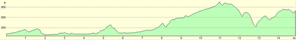
For more information on profiles, ascents and descents, see this page
Accommodation
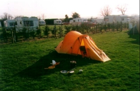
I stayed at a campsite at Highfield Farm, near Thorpe and Fenny Bentley that night. It was a fairly nice campsite with good facilities (including a swimming pool), and cost Ł5.50 a night. It was very convenient for the route of the Limestone Way, being only about 1/3 of a mile from the Way.
Transport
Unfortunately the Peak District is notorious for having highly non-optimal public transport. The main towns and villages all have semi-regular services, but many smaller places only have irregular (and sometimes unreliable) services.
Doveridge is only two miles from Uttoxeter, and has regular bus services to the larger town, which has a railway station. Thorpe has some bus services to Ashbourne, and busses can be caught from Ashbourne to the railway stations at Derby, Uttoxeter or Buxton.
Disclaimer
Please note that I take no responsibility for anything that may happen when following these directions. If you intend to follow this route, then please use the relevant maps and check the route out before you go out. As always when walking, use common sense and you should be fine.
If you find any information on any of these routes that is inaccurate, or you wish to add anything, then please email me.
All images on this site are © of the author. Any reproduction, retransmissions, or republication of all or part of any document found on this site is expressly prohibited, unless the author has explicitly granted its prior written consent to so reproduce, retransmit, or republish the material. All other rights reserved.
Although this site includes links providing convenient direct access to other Internet sites, I do not endorse, approve, certify or make warranties or representations as to the accuracy of the information on these sites.
And finally, enjoy your walking!
This walk was mentioned in the following routes:
| My sectional Land's End to John O'Groats walk |
Nearby walks
| # | Title | Walk length (miles) |
|---|---|---|
| 14 | Friden, Long Dale and Gratton Dale | 7.8 |
| 24 | The Weaver Hills | 6.0 |
| 68 | Willington to Doveridge | 12.6 |
|
|

|