Walk #655: A circular walk from Ware
 |
 |
|
General Data
| Date Walked | 13/03/2005 |
| County | Hertfordshire, Essex |
| Start Location | Ware station |
| End Location | Ware station |
| Start time | 08.20 |
| End time | 15.60 |
| Distance | 19.7 miles |
| Description | This was an enjoyable walk taking in part of the Lea Valley path and some woodland walking. |
| Pack | Today I carried my 30-litre Karrimor rucksack, filled with my usual set of detritus, including waterproofs, water and my electrical gear. |
| Condition | I have a couple of small blisters on my little toes after this walk, a result of only wearing one pair of socks for this walk. Aside from this I feel fine, although slightly fatigued. |
| Weather | The day started off sunny with little cloud in the sky, but also bitterly cold. The skies clouded over as the day progressed, but aside from about a minute of wet sleet there was no precipitation. The wind was again bitterly cold, and I was glad when I was not exposed to it. |
| OS map | Landranger number 168 (Colchester, Halstead & Maldon) |
 |
 |
|
 |
 |
|
Map of the walk
Maps courtesy of Google Maps. Route for indicative purposes only, and may have been plotted after the walk. Please let me have comments on what you think of this new format. For a detailed table of timings for this walk, please see the table file.
 |
 |
|
Notes
After yesterday's walk I really did not fancy walking too far, and so I used my PC mapping program to decide on a walk. Years ago I walked along the Lea Valley Walk northwards through East London, before branching off to head along a canal towards Bishops Stortford. At the time I considered doing another walk following the Lea Valley as it headed northwestwards from the junction towards Hertford, but the opportunity never arose. Looking on the maps of walks that I have done, I saw an obvious gap in Hertfordshire, and after ten minutes I had finalised a circular route taking in the canal and a large area of woodland.
The drive down to Ware was easy enough, and when I arrived at the station car park I was slightly surprised to see that there was only one car in it. It cost me one pound to park in if for the day, which was a shame as WAGN car parks used to be free on Sundays (although I do not know if this particular car park has always been free). A building between the car park and the station was under renovation and the narrow gap between the building and the railway line was surrounded by scaffolding, which meant that I had a form of tunnel to walk through.
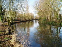
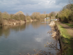
Once at the station I was keen to set off, and I walked the short distance along roads to reach the canalised Lea River, stopping off on the way to pick up some chocolate bars for the day. There were lots of swans and sucks n the river, and as I walked along through Ware (the riverfront of which was quite pleasant) they followed me; they are obviously very used to people feeding them. The canal towpath was firm underfoot and I thoroughly enjoyed the stroll, although it was fairly chilly, especially when I was exposed to the bitter northerly wind.
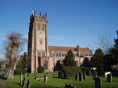
The river soon approached the centre of Hertford, and here I left the river and started to head south through the town, trying to follow the Hertfordshire Way. This proved hard to do in practice as there were not many signs for the route in the town, and I managed to find a subway under the dual carriageway road by dead reckoning rather than by following signage. It was my first time in Hertford and I felt like it was quite a cosy little place; by far not the best place that I have ever been to, but pleasant enough.
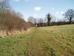
I lost the Hertfordshire Way once again when heading through a churchyard, but again dead reckoning allowed me to pick it up on a road a little further south; the route I chose seemed obvious on the ground, and the proper route was not at all clear from looking at my Ordnance Survey map. It did not make any difference and I was soon walking through a housing estate in the southern suburbs of Hertford. The houses were soon left behind, and the path crossed the railway line and started following it as it headed southwards. This stretch of path was wooded, but it was only scrubby, first-generation style woodland that made the walk fee quite enclosed and oppressive in places. I enjoyed it though, and even the occasional train running by on the adjacent embankment did not bother me too much. The path eventually left the trees and skirted the edge of the woods before heading into the village of Bayford.
The pub in Bayford was not yet open, and so I walked on and joined a bridleway that headed south through Blackfan Wood. Near the end of this I could see a strange, alien-looking circular structure through the trees to my right; this turned out to be an air traffic control radar site similar to the one that I know well on a hill near Carsington Reservoir in Derbyshire. I could not really understand why it was located here; it was hardly high ground, and as there are only a handful of these radars throughout the country I would have thought that there would have been far more optimal locations.
The bridleway ended at a road, and I was forced to walk along it eastwards. Unfortunately it was fairly busy, and as the first stretch was quite winding I frequently had to step onto the verge to avoid oncoming cars. When the road crossed the course of the Ponsbourne railway tunnel, deep underground and only detectable by an air shaft in a field to the left, the road became straighter and I could make better time for the short distance to a bridleway. This led me up to another road, and this led for a few yards to a car park at the outskirts of Broxbourne Wood.
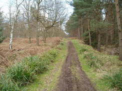
I had been planning to walk through this wood on a track that is clearly marked on the Ordnance Survey map as heading off in a northeasterly direction. Initially this was easy to follow as it was a wide track heading directly away from the car park, but after a few hundred yards it became less distinct and appeared to end at a wooden barrier designed to stop motorbikes. There was an obvious track heading away in an easterly direction, but I chose to walk through the woodland northeastwards, which was not the easiest going and eventually I rejoined what must have been the same track. This stretch of track made for a pleasant walk through the trees but it was severely rutted from motorbikes and horses, which made progress slow in places as I had to divert off the main track to avoid going ankle-deep in the thick, glooping mud.
A series of adjoining woods followed; Broxbourne Wood was followed by Cowheath Wood, and that in turn was followed by Highfield Wood. The boundaries of these woods were indiscernible on the ground, and it was only when I reached Hoddesdon Wood and a large sign proclaiming 'Welcome to Hoddesdon Wood' that I realised that I had left Broxbourne Wood. On the map the track ends in the middle of Hoddesdon Wood and my planned route diverted northwards to a road, but on the ground it continued on eastwards, which cut about a mile off the total distance of the day's walk. I was happy about this as the new route cut down the amount of road walking that I would have to do, which is generally an advantage.
Once the edge of Hoddesdon Wood was reached I joined a footpath that headed southwards, skirting the edge of the A10(T) dual carriageway before ending at a road. The road allowed me to cross the A10(T) on a bridge, and once on the other side I followed another footpath that headed down towards a housing estate. This had grown somewhat since my map had been printed, but I found it fairly easy to make my way down to the A1110 in Hoddesdon and then on down the B194 to the Lea River in Nazeing. I joined the towpath that runs along the eastern bank of the river and started following it northwards. It almost immediately passed a lock, and a few hundred yards further on I passed a large collection of flowers and a few teddy bears. This caused me to pause, and I soon realised that these had been laid out as a memorial to a mother and her two children who had died when their car had driven at speed into the river three weeks before. It made for a poignant, sad sight, and after paying my respects at this unofficial shrine I turned away with a tear in my eye and solemnly continued northwards along the towpath.
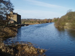
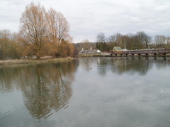
As I walked I found that my mind was occupied, and that much of the joy of the walk had been removed. In order to get some perspective I went into the canal side pub at Dobb's Weir, which was bustling on this Sunday lunchtime. I ordered a pint and sat down, flicking through my book of walking notes and eventually managed to get my mind off the tragedy and onto happier subjects. I felt out of place in the pub with my walking gear on, so as soon as I had finished the pint I left and continued walking along the towpath. The river in this area is dominated by a series of high tension power cables that span the river from a nearby power station, and this gave the next stretch of walk a very urban, industrialised feel. These had finished by the time that I reached the next lock, Feildes Weir, which marked the junction with the River Stort Navigation.
A few years ago I had walked up the River Stort as part of my Land's End to John O'Groats walk, but today I was heading off in the other direction, up the River Lea. The pint was having the effect of making my mind wander even more than usual, and as the river/canal headed northwards through Rye and St Margaret's I felt like I was flying along; before I knew it I was approaching Ware once more. The riverside through Ware is surrounded by some very smart and tidy blocks of flats, and I enjoyed looking at these as I strolled along towards the bridge where I had first joined the river this morning. I soon reached the bridge, and before I knew it I had reached the railway station and, shortly afterwards, my car. This had been a fulfilling walk, and whilst it was not in the most scenic part of the country it had nonetheless been enjoyable.
Directions
This walk starts off at Ware railway station in Hertfordshire. Leave the station and turn left to walk west along Station Road for about a hundred yards until it ends at a T-junction with Amwell end. Turn right and follow this road northwards, passing the junction with Viaduct Road to the right before reaching a bridge over the River Lea. As soon as the bridge is reached turn left and start following the towpath that runs westwards along the southern bank of the river. Keep on the towpath as it passes Ware lock and then heads on, passing under the A10(T) bridge and heading on t0wards Hertford. When the Old Barge pub is reached on the right continue on for a few yards to the next bridge and then leave the towpath, turning left to start walking southwards through Hertford. Here the route also joins the Hertfordshire Way, which it will be following for the next few miles.
Head south through the town, along Priory Street and then turning slightly to the right to make for a subway under the A414. Pass under the subway, and once on the southern side of the road take path that passes the church and heads south through the churchyard. When this path ends at Hagsdell Road turn right for a few yards until it ends at Queens Road. Turn right and start following Queens Road southwards as it slowly climbs uphill. When the road curves sharply to the right to become Morgans Road turn right at the apex of the bend, to start following a footpath that heads westwards between two hedges that shelter a school from the path. When the path ends at Wilton Crescent turn left for a few yards until the crescent ends, and then turn left to start following the looping Mandeville Road.
When Mandeville Road ends at Brickendon Road turn left along the latter for a few yards before turning right along a footpath. This skirts to the left of a hedge as it heads slightly west of south, eventually reaching a footbridge over a railway line. Cross the footbridge and once on the other side turn left and start following the footpath as it heads south through an area of scrub woodland, initially sticking close to the railway line embankment before eventually emerging from the trees and moving away from the embankment slightly. The path continues along the edge of a field, before turning sharply to the right to head westwards, slightly to the north of Place farm. When a track is reached turn left, and follow the track as it heads south, becoming Bayford Green road as it heads south into Bayford, where the Hertfordshire Way is left. At a junction turn left along Brickendon Road for a few yards until the road swings to the left; here turn right along Stocking Lane.
The next mile follows the Chain Walk as it heads through Gidner's Wood, turning sharply to the right before following the edge of the woodland southwards. The path ends at Stubbs Lane near the Kingfisher Garden Centre; turn left and start walking eastwards along the road as it passes Old Claypits Farm on the left and passes over the course of the Ponsbourne Tunnel. Shortly after a cattery is passed on the right turn left along a bridleway called Devil's Lane. The bridleway is broad and is a nice walk through the trees, and it ends after about half a mile at Pembridge Lane. Turn right along the lane as it heads southeastwards for a few hundred yards; when the Broxbourne Wood west car park is reached, enter it and start walking northeastwards through Broxbourne Wood along an obvious track. The track is relatively wide and easy to follow as it enters Cowheath Wood, and it slowly curves to take amore easterly course as it enters Highfield Wood and finally Hoddesdon Wood.
When the track suddenly emerges from the eastern edge of the woodland turn right along a track that heads south towards a house. The track ends at the house, but a footpath continues onwards, heading southeastwards towards the A10(T). It then follows the western side of the A10(T) southwards until it ends at Cock Lane. Turn left and head across the A10(T) using the road bridge, and immediately on the other side turn right into a car park and then join a footpath that heads southeastwards across fields, passing to the west of a small patch of woodland called Lucern Warren before entering Crabtree Plantation. When a footpath junction is reached leave the footpath and join Woodstock Road, and start following it southeastwards. When the road ends at a T-junction turn right along Park Lane, and follow it as it swings to the left to continue on southeastwards. When the road ends at the A1170 Broxbourne High Street turn left and then almost immediately turn right, to head eastwards along the B194 Station Road. The road climbs to cross the railway line near to the railway station, and then on to reach the bridge over the River Lea.
Cross the bridge and once on the eastern side turn left to join the towpath, which at this point follows a wide track. Follow this northwards as it passes Nazeing Lock, and heads on towards Dobb's Weir Lock. Here the towpath uses the road bridge to swap over to the western side of the river, and heads eastwards before curving to head northwards to Feilde's Weir Lock and the junction with the River Stort navigation. Continue on along the towpath as it curves to head in a more northwesterly direction, passing through Rye before heading under the A414 bridge and entering St Margarets. The towpath continues along the southern side of the river as it heads northwestwards, passing Stanstead and Hardmead Locks before entering the outskirts of Ware. When the bridge that carries Amwell Road over the river in the centre of the town is reached, leave the towpath and start following Amwell Road south for a short distance until Station Road leads off to the left. Turn left and follow Station Road eastwards for about a hundred yards to Ware Station, where this walk ends.
Distances
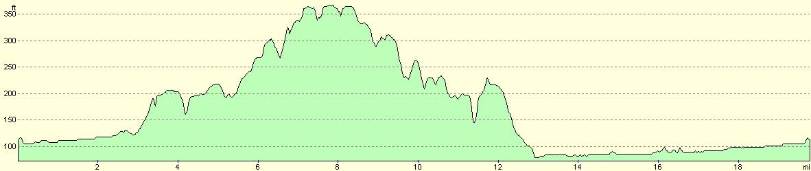
| From | To | Distance (m) | Ascent (ft) | Descent (ft) |
|---|---|---|---|---|
| Ware railway station | Hertford | 2.9 | 39 | 30 |
| Hertford | Bayford | 3.4 | 279 | 102 |
| Bayford | Nazeing | 6.9 | 397 | 612 |
| Nazeing | Ware railway station | 6.5 | 95 | 66 |
This makes a total distance of 19.7 miles, with 810 feet of ascent and 810 feet of descent.
For more information on profiles, ascents and descents, see this page
Disclaimer
Please note that I take no responsibility for anything that may happen when following these directions. If you intend to follow this route, then please use the relevant maps and check the route out before you go out. As always when walking, use common sense and you should be fine.
If you find any information on any of these routes that is inaccurate, or you wish to add anything, then please email me.
All images on this site are © of the author. Any reproduction, retransmissions, or republication of all or part of any document found on this site is expressly prohibited, unless the author has explicitly granted its prior written consent to so reproduce, retransmit, or republish the material. All other rights reserved.
Although this site includes links providing convenient direct access to other Internet sites, I do not endorse, approve, certify or make warranties or representations as to the accuracy of the information on these sites.
And finally, enjoy your walking!
Nearby walks
| # | Title | Walk length (miles) |
|---|---|---|
| 51 | Mile End to Enfield Lock | 12.7 |
| 52 | Enfield Lock to Harlow Town | 12.6 |
| 53 | Harlow Town to Bishop's Stortford | 9.8 |
|
|

|