Walk #169: Shippea Hill to Littleport via Ely
 |
 |
|
General Data
| Date Walked | 09/12/2001 |
| County | Cambridgeshire |
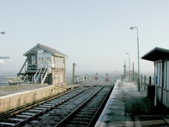
| Start Location | Shippea Hill Station |
| End Location | Littleport Station |
| Start time | 09.47 |
| End time | 15.25 |
| Distance | 15.6 miles |
| Description | This walk follows the Hereward Way from Shippea Hill southwest to Ely, and then along the Fen River's Way north following the River Great Ouse to Littleport. |
| Pack | I carried a 30-litre daysack containing coat, trainers, digital camera and a spare top. |
| Condition | I feel fine after this walk. With a little rest I could easy have walked on for another three or four miles. My legs are fine, with no sign of fatigue and I have not had any trouble from any other parts of my body either. |
| Weather | Today's weather was lovely, with scarcely a cloud scarring a beautiful blue sky. There was a hint of fog in the air, particularly earlier on on the day, which spoiled what could well have been expansive views over the fens. The weather was also quite cold, and it took me ten minutes after I started walking after lunch to warm up again. Fortunately there was no wind to make this problem worse and so it was a fairly comfortable day. |
| OS map | Landranger number 143 (Ely & Wisbech, Downham Market) |
 |
 |
|
Map of the walk
Maps courtesy of Google Maps. Route for indicative purposes only, and may have been plotted after the walk. Please let me have comments on what you think of this new format. For a detailed table of timings for this walk, please see the table file.
 |
Notes
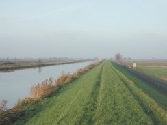
This was a lovely walk, despite the fact that the height gain in metres could probably be counted on one hand! Despite the flatness of the Fens there was still much to see, although this was focussed more around the horizon than is the case in hilly areas.
The main aim of this walk was to walk from Ely to Littleport, and hence finish off my walk around East Anglia. Because this little walk was only six or seven miles long, I decided to extend it by walking to Ely from Shippea Hill, following the Hereward Way. Unfortunately when planning this I failed to measure the distance of this first stretch and I guestimated it at about six miles; unfortunately when I got there I found that this was very probably an underestimate.
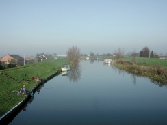
The first few miles of the walk was a long stroll along the A1101 road, which fortunately was not too busy that early on a Sunday morning. This was followed by another long stroll along the quieter B1382 until the attractive little village of Prickwillow was reached. In Prickwillow I passed over a bridge that crosses the River Lark and got some nice views northwestwards along the river which came complete with the obligatory anglers.
The quietest part of this walk was the stretch between Prickwillow and Ely, which followed a footpath along a small and sometimes muddy track. Unfortunately this stretch had to end too soon, and the last mile followed a road south to Ely station.
When I got to Ely I called in at the station to get train times from Littleport and to buy a pack of crisps and a Mars bar. Fortunately I discovered that trains were running every hour, whilst I had thought that they ran every two hours on Sundays. This pleased me as it meant that I would not have to wait long for the next train once I got to Litleport, and therefore I could be in less of a hurry. After this I walked along to the Maltings in Ely, which was very busy so I drank my pint of John Smith's sitting outside in the sun.
I have walked the section of the walk from Ely to Littleport before, in 1998, as part of a Waterbeach to Littleport walk. Unfortunately this was before I logged my walks (which started in January 1999), so I have had to do it again to get data. This is probably why I left it until the end of my walk around East Anglia; the seven mile stretch was shorter than I normally like a day walk to be, and I had done it before anyway.
The four-mile stretch from Queen Adelaide Bridge north to Littleport was fairly nice, although some people could call it boring. The path follows either side of the River Great Ouse as it heads straight northwards, straddling the large floodbanks that line the river. Which side you walk on is a matter of personal choice; the western side is quite remote, and you will have to be sure to want to walk the full distance as there are few access points along the route as the path is jammed between the river and the railway. The eastern side is quite different; the path is trapped between the river and a minor but busy road. I chose to walk along the road because it would give me the option to walk along the road if the path was too muddy, an option that I fortunately did not have to use.
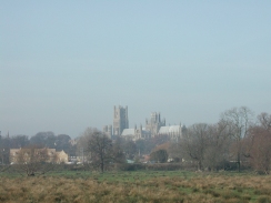
Ely is a very attractive place, and is dominated by the large cathedral which can be seen for miles around. Although the day was rather hazy, this had one good effect because the cathedral looked very aetherial over the floodplains of the Great Ouse whilst I was walking towards the station - a very nice sight.
Directions
This walk follows two long distance footpaths - the first being the Hereward Way and the second the Fen Rivers Way. It starts at Shippea Hill Station, on the Ely to Norwich railway line. Turn left out of the station and follow the A1101 road northwestwards for a mile and a half to the junction with the B1382.
Turn left and follow the B1382 south-southwestwards for a mile and a half, crossing over the railway line before reaching Prickwillow. Cross over a bridge over the River Lark and continue westwards through the village until the junction with the B1104 to Isleham is reached.
At the junction turn left and then immediately right past a triangular junction to go down a small lane called Old Bank. This lane slowly bends around from a southwesterly to a westerly direction as it becomes a track and crosses Swasedale Drove. It then starts to head southwestwards for a couple of miles until it meets a road, Queen Adelaide Way, beside the Great Ouse.
Turn left and walk down Queen Adelaide Way. Beside the road is a large floodbank, which can be walked along to avoid the road if necessary. After about a mile and a half the road ends at a T-junction with the A142. Turn right along the A142 and cross over the Great Ouse. Continue across the railway line and Ely station is immediately to the left across the A142. Creos over the road and go to the station, where a shop sells a few snacks.
Turn left out of the station and use the pedestrian crossing to cross over to the northern side of the A42. Continue on for about fifty yards to a roundabout. At the roundabout turn right and walk down a small road for a short distance until the river is met.
Continue on along the river until the Maltings, now a bar and cinema complex but once an old maltings, is reached. Walk slightly beyond this and then turn left down Wasterside Road until a more major road, Lisle Lane, leads off to the right. Turn right and follow Lisle Lane until it ends at a T-junction with the B1382 Prickwillow Road.
Turn right along the B1382 and follow it for about a kilometre until the northern edge of some lakes are reached. Take a track that leads past a building beside the lake and heads to a railway line. Cross this line and take a footpath that heads across fields to an almost obscured stile in the far corner.
Go over the stile and cross another railway line which is on the other side. Walk along a footpath for a short distance until another railway line is met. Turn left and follow a footpath which runs northeastwards beside this railway line until the B1382 is met at Queen Adelaide.
Turn right along he B1382 and cross the railway line. A short distance to the east the Great Ouse is crossed. On the eastern side of the bridge a road leads off to the left, heading northwards. Between the river and the road is a floodbank, along the top of which runs a footpath. Either follow the path along the top of the floodbank or along the road northwards, passing two bends in the road in the process.
The first of these bends can be avoided if you are following the floodbank as the footpath continue straight on alongside the river. The second bend, where the River Lark meets the Great Ouse, is different and you will have to join the road for a short distance to cross the bridge.
Eventually a large bridge across the river is reached to the east of Littleport. Turn left across the bridge and follow Victoria Street across the railway line. Continue along Vicroria Street for a while as it becomes Main Street until the Crown Inn is reached on the right. Turn right down Crown Lane past the Inn and then almost immediately turn right again, to head east through the village along Wellington Street. At another junction turn left and head northeastwards along Station Road for about a kilometre until Littleport station is reached.
Distances
| From | To | Distance (m) | Ascent (ft) | Descent (ft) |
|---|---|---|---|---|
| Shippea Hill station | Ely station | 8.6 | 33 | 30 |
| Ely station | Littleport station | 7.0 | 131 | 138 |
This makes a total distance of 15.6 miles, with 164 feet of ascent and 168 feet of descent.
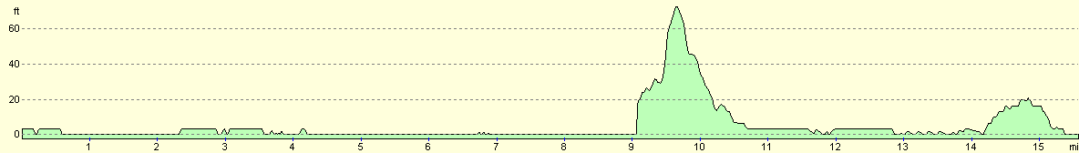
For more information on profiles, ascents and descents, see this page
Transport
There are regular train services running from Littleport to Ely, run by WAGN trains. There are also some services east from Ely to Shippea Hill station, but these are unfortunately very infrequent. For this reason my girlfriend very kindly dropped me off at Shippea Hill station, and from there I walked to Ely and then Littleport. From Littleport I caught the train to Ely and then Cambridge, where I live.
Disclaimer
Please note that I take no responsibility for anything that may happen when following these directions. If you intend to follow this route, then please use the relevant maps and check the route out before you go out. As always when walking, use common sense and you should be fine.
If you find any information on any of these routes that is inaccurate, or you wish to add anything, then please email me.
All images on this site are © of the author. Any reproduction, retransmissions, or republication of all or part of any document found on this site is expressly prohibited, unless the author has explicitly granted its prior written consent to so reproduce, retransmit, or republish the material. All other rights reserved.
Although this site includes links providing convenient direct access to other Internet sites, I do not endorse, approve, certify or make warranties or representations as to the accuracy of the information on these sites.
And finally, enjoy your walking!
This walk was mentioned in the following routes:
| A walk around East Anglia |
Nearby walks
| # | Title | Walk length (miles) |
|---|---|---|
| 3 | Littleport to Downham Market | 14.0 |
| 7 | Waterbeach - Burwell - Swaffham - Waterbeach | 17.1 |
| 15 | Waterbeach circular via river and Long Drove | 7.4 |
|
|

|