Walk #195: Black Bridge to Croick Church
 |
 |
|
General Data
| Date Walked | 30/04/2002 |
| County | Highlands |
| Start Location | Black Bridge |
| End Location | Croick Church |
| Start time | 09.25 |
| End time | 17.20 |
| Distance | 19.6 miles |
| Description | This is a highly pleasant and interesting walk along good tracks with some great mountain scenery to be viewed. This was one of the best walks of the trip so far. |
| Pack | Full pack with five days food. |
| Condition | Considering this was a long walk I feel remarkably okay after this walk. My feet ache slightly, but nothing too major considering the distance that I have done. The biggest problem that I have had is with chafing between my legs which was causing problems on the last five miles. I have put Savlon on it and then in the morning I will put Vaseline all over the affected areas. |
| Weather | The weather today was dominated by rain, which occurred on and off during the day. It started off with a light drizzle that became heavier for a while and then stopped. This occurred throughout the day, with long dry patches (albeit with no sun) and very wet spells. Unfortunately the last hour was wet so I had to put my tent up in the wet. The temperature was quite mild but I did have my fleece on under my coat, and the wind was gentle, which is a big change from yesterday. |
| OS map | Landranger number 20 (Beinn Dearg & Loch Broom, Ben Wyvis) |
 |
 |
|
Map of the walk
Maps courtesy of Google Maps. Route for indicative purposes only, and may have been plotted after the walk. Please let me have comments on what you think of this new format. For a detailed table of timings for this walk, please see the table file.
Notes
This was a great walk, and I have managed to complete far further than I intended - twenty miles is a very good distance with the weight that I am carrying. It was also a very scenic walk, and I took lots of photographs which I am sure will not be able to take in the full grandeur of the scenery.
The tracks that I was following were very good, and they did not hurt my feet too much. This route is a very useful link from the main roads to the north and the south, which could be one of the reasons that the relevant estates keep the tracks in good condition. The presence of the dam, the loch and the lodges would also mean that the tracks are well used.
I used the public phone box at The Craigs to phone Sam, and it was absolutely lovely to hear her voice. From tomorrow I should not be out of contact for a few more days (I should be able to phone her from the Oykel Bridge Hotel when I get there tomorrow) and so I will be able to talk to her more often. I really am missing her, and I wish that she could be here with me now. My heart yearns for her.
I stopped for lunch at Deanich Lodge, and I sheltered from the light drizzle that was then falling in an open-fronted wood shed. As I sat planning the rest of the day's walk I heard the sound of a motorbike in the distance getting closer. I left the shed just in time for two motocross bikes to pull up beside me, and I started to chat to the two riders. They were based in Ullapool and they were riding along tracks in the Highlands. The fuel tanks of the bikes only stored enough fuel for sixty miles, but they had enough for another forty miles on the back of their bikes and they had stashed more fuel near Black Bridge. They were very nice people and I stood in the rain and watched them disappear up the hillside to the north.
As I approached the high point of the track above the dam of Loch Vaich I could see someone with a small daysack sitting down just off the track. As I got nearer he stood up and I had a chat with him. He was 72, and had just done the short walk to the dam as a morning's walk. I can only hope that I can do such a walk when I am 72!
By the time I had reached the public phone box at The Craigs I was fairly tired and the rain was falling steadily. I left a message for Sam on our answer phone but then saw a lady walking a couple of dogs outside. I hung up the phone and asked her about camping places. We had a quick chat but she was only visiting her brother and therefore could not really help me. After going back into the phone box to call Sam on her mobile I decided to walk on towards the end of the road at Croich Church.
On the way I met a car coming the other way. There were newborn lambs all over the road and I asked him where I could camp. He suggested camping by the old church,and hence my tent is erected in a space in the graveyard. This could be seen as being spooky, but in the case of Croich Church it is not so bad - the church became famous in 1845 when crofters displaced by the Highland Clearances used it as a shelter. Whilst they were in the church some of them engraved their names on the east window. As an Englishman I find this incident shameful, but quite why I do not know - I do not know if the clearances were caused by the English. For more details of the clearances, see The clearances in Glencalvie and Croick Church.
There is also an ancient pictish Broch nearby, which unfortunately was nothing more than an irregular jumble of stones. The definition of a broch can be found in this paper, and can be summarised as being circular drystone towers found in the region of the Atlantic Coast of Scotland. I was to see many other Broch's on the Ordnance Survery maps during the rest of this trip, but I was not able to make out any others on the ground (although I only looked over towards them rather than search them).
I have only about ten miles to walk tomorrow to get to Oykel Bridge, which will probably be used for lunch. After that I will probably walk as far north-westwards as I can along the A837 road towards Ledmore. This means that I will probably have to spend tomorrow night in the tent as well, which means that I really hope that it does not rain again tomorrow. If it does rain hard I could be very tempted to shell out the forty-nine pounds for B&B at the hotel.
Directions
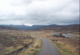
This walk starts off at Black Bridge, the bridge that carries the A835(T) over the Abhainn Srath a' Bha'thaich. On the eastern side of the bridge there is the start of a surfaced road that heads northwestwards to a couple of buildings. Continue on the road past the buildings and go through a gate. The road then heads for a couple of miles along the tarmac road until the farm at Lubriach is reachde on the right.
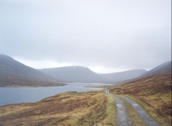
Just after the farm the road turns left to cross the river by means of a bridge, leading to Strathvaich Lodge. Do not cross this bridge but turn right along a track that head uphill to the north immediately before the bridge. This track heads north for a kilometre beside some forestry to another track junction. Do not take the minor track that leads off to the right but turn left and follow the track as it climbs upto the top of Coir' a' Ghrianain above the dam of Loch Vaich.
Follow the track as it heads northwards along the eastern bank of Loch Vaich. A little over a mile after it passes the old buildings at Lubachlaggan the head of the loch is reached. After this the track starts to turn to a more easterly heading, slowly climbing past the summits of Meall a' Chuaille and Meall a' Chaorainn. After crossing a burn it starts a short climb up the shoulder of the latter mountain. At the summit of the track anothr track leads off downhill to the right; ignore this track and continue straight on and start descending for a kilometre to another junction. At this junction turn right and descend the short distance down to Deanich Lodge.
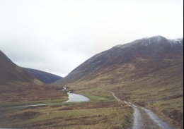
From the lodge follow the track as it heads northeastwards to a bridge over the Abhainn a' Ghlinne Mho'ir. The track crosses the bridge and then follows the northern bank of the river for about six miles, psssing through two deer gates and past two wooden huts. Shortly after the second hut the track starts to climb through some pretty woodland before descending to a bridge over the Alladale River immediately to the southeast of Alladale Lodge.
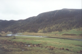
Cross over the bridge to meet a T-junction in the track. Turn right to head eastwards through the woodland high on the northren bank of the Alladale River, which passes through a series of gorges and rapids. After a couple of kilometres a road is met near Glencalvie Lodge. Continue straight on along the road (do not descend to the right down to the bridge) and follow it as it turns to head northwards to meet the bridge over the Blackwater River at the Craigs.
Immediately over the bridge the road ends at a T-junction by a telephone box. Turn left and follow the road for a mile as it heads northwestwards to the church at Croick.
Distances
| From | To | Distance (m) | Ascent (ft) | Descent (ft) |
|---|---|---|---|---|
| Black Bridge | Deanich Lodge | 9.5 | 1066 | 869 |
| Deanich Lodge | Croick Church | 10.1 | 699 | 1237 |
This makes a total distance of 19.6 miles, with 1765 feet of ascent and 2106 feet of descent.
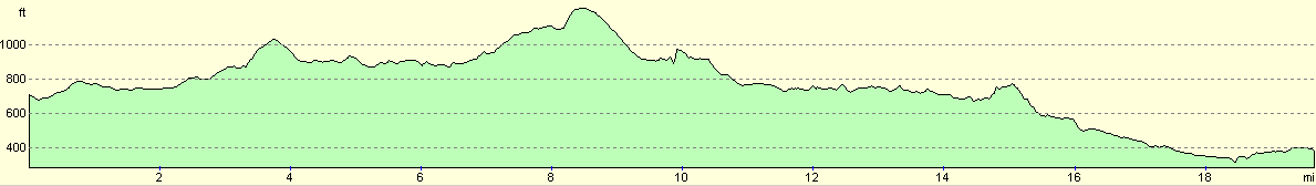
For more information on profiles, ascents and descents, see this page
Accommodation
I stayed in my tent beside Croich Church. There is a burn on the other side of the church which can be used for water, and there is a public telephone a mile to the east down the road.
On the walk today I saw several places which could be used for camping, and several of these had buildings beside them. The buildings at Lubachlaggan beside Loch Vaich looked as if they did not have any doors on them, although I did not descend from the track to investigate them. At Deanich Lodge there is an open-fronted building in which a warm night could be spent, and on the descent down Gleann Mo'r there are two wooden huts; the first just has a rock holding the door shut and the second has a lock, but the key was in the lock! The first had been used to store grain or something similar as it was spread all over the floor. The second had a couple of pallets and a chair, as I recall. Always ask permission before sleeping in such buildings; they are working estate buildings and not bothies.
Disclaimer
Please note that I take no responsibility for anything that may happen when following these directions. If you intend to follow this route, then please use the relevant maps and check the route out before you go out. As always when walking, use common sense and you should be fine.
If you find any information on any of these routes that is inaccurate, or you wish to add anything, then please email me.
All images on this site are © of the author. Any reproduction, retransmissions, or republication of all or part of any document found on this site is expressly prohibited, unless the author has explicitly granted its prior written consent to so reproduce, retransmit, or republish the material. All other rights reserved.
Although this site includes links providing convenient direct access to other Internet sites, I do not endorse, approve, certify or make warranties or representations as to the accuracy of the information on these sites.
And finally, enjoy your walking!
This walk was mentioned in the following routes:
| My sectional Land's End to John O'Groats walk |
Nearby walks
| # | Title | Walk length (miles) |
|---|---|---|
| 193 | Beauly to Garve | 16.4 |
| 194 | Garve to Aultguish Inn | 9.2 |
|
|

|