Walk #194: Garve to Aultguish Inn
 |
 |
|
General Data
| Date Walked | 29/04/2002 |
| County | Highlands |
| Start Location | Garve |
| End Location | Aultguish Inn |
| Start time | 12.20 |
| End time | 15.20 |
| Distance | 9.2 miles |
| Description | This was a long plod along a main road, but the spectacular scenery more than made up for the hard tarmac underfoot. The mountain tops had a light scattering of snow, and this made the views (when I could see them through gaps in the low cloud) fantastic. |
| Pack | I carried no pack on this walk as none was necessary. |
| Condition | I am fine after this walk, as I was carrying no pack nothing really gave me any bother. I had a few twinges from my right knee but nothing to overly concern me. |
| Weather | Today started off with a heavy rain accompanied with a strong wind. As the day went on the rain slowly lessened until near the end of my walk it was just a light drizzle. Unfortunately as the rain lessened so the wind gained, and the wind at the end of the walk was very strong indeed, and was blowing straight into my face which made progress difficult. |
| OS map | Landranger number 20 (Beinn Dearg & Loch Broom, Ben Wyvis) |
 |
 |
|
Map of the walk
Maps courtesy of Google Maps. Route for indicative purposes only, and may have been plotted after the walk. Please let me have comments on what you think of this new format. For a detailed table of timings for this walk, please see the table file.
 |
Notes
I woke up this morning to see continuous rain, snow on the top of the mountains in the distance and the river considerably higher than it had been before I had gone to bed the previous night. I went down to breakfast at eight in the morning, and I started to weigh up the options for the day. Whilst I did not fancy camping out in such weather I also did not want to not do a walk. After thinking about the problem for a while, I talked to the landlord of the B&B and decided that I would walk without pack to the Aultguish Inn, almost two miles past Black Bridge, which was the start of my route to Oykel Bridge. Doing this would allow me to do a decent walk today, get the road walk out of the way and give myself a rest as I would have no pack.
Because it was going to be a relatively short walk I decided to spend the morning writing up the directions for some of the previous walks on this trip so that I could send the maps home. I also finished the first book of the Lord of The Rings trilogy so that got dispatched home as well. Although these items did not weigh that much they were quite bulky so my pack should now be slightly more roomy.
I then walked down to the tiny post office in the village so that I could send the parcel, second class as I was in no hurry to receive it. During this short walk my coat got very wet, so I was well aware that I would have to wrap up well for the forthcoming walk. The cloud cover looked fairly heavy, and the rain was of the sort that was not too heavy but continuous, so that I got just as wet as I would have if it had been a torrential downpour for ten minutes.
Yet again the owners of the B&B have been absolutely marvellous - they have been exceedingly helpful and their kindness in picking me up today has really helped me on this walk. It would be very nice to get the opportunity to visit this B&B again in the future especially as there are so many nice walks and munros in the immediate area.
The Aultguish Inn was very nice, and I had a pint and a half and an omelette before I phoned the landlord to get my lift back to the B&B. The people in the Inn were very friendly and I had a long chat with them. The Inn specialises in walkers and climbers, and even has large black footprints all over the exterior walls, which makes it a highly noticeable venue. They also had a bunch of other outdoors magazines in a pile, so I skimmed through these whilst waiting to get picked up. The Inn also has a bunkhouse attached to it, which gets very busy in the summer as munroists use the Inn as a base.
The biggest feature of this walk was the weather, which was absolutely awful for all of the morning. Although it got better as the day wet on, it was still far from ideal walking weather. The wind in particular was fearsome towards the end of the walk at the Aultguish Inn, when it was literally trying to blow me back for every step forward that I took. Such strong wind makes walking much more energetic than it should be, and I got far more tired walking the last couple of miles than I did on the rest of the walk.
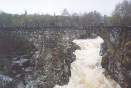
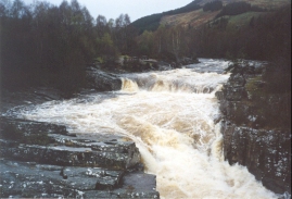
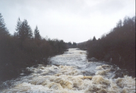
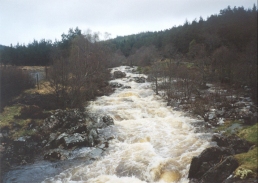
The one good thing about the rainfall was that all the streams and rivers were in spate, which made for some glorious white water where they went over rocks. The view was particularly spectacular at the point where the A835(T) road crosses the Black Water at Blackwater Bridge. Here the old bridge made a beautiful backdrop as white water shot at speed through one of the arches. There were similar effects elsewhere, particularly in one place nearby where water just poured over the side of the rock road cutting. This was all very picturesque, and added a lot of interest to what could have been a boring walk.
The difference that not having a pack on made is very, very large - my whole body felt less strained and more relaxed for the entire walk. This made me realise exactly what I had been putting my body through for the last nine days, and it has probably done me much good to remove that strain for a day. I wish that I could complete the rest of the journey with no pack, but of course that is unworkable.
The weather forecast for tomorrow is for cloud in the morning followed by rain in the afternoon. This means that when I camp tonight I can expect to be wet.I have also phoned up the hotel at Oykel Bridge, and a bed and breakfast bed for the night is forty-nine pounds! I will have to be very wet to stay there rather than camp, although I will have a meal there if the timing is right.
I have measured the remaining distance to Oykel Bridge as being about 31 miles, which means two long walks to get there within two days. It should be possible to do it, as long as the weather does not throw any spanners into the works. The route seems to be quite clear, with tracks marked on the OS map the whole way - whether this is the case on the ground is a different matter. There is a public phone before Oykel Bridge, so I should be able to phone Sam up sometime early on Wednesday if everything goes according to plan.
Directions
This walk starts off at the B&B that I am staying at, which is about half a mile north of Garve along the A835(T). Turn right and head northwards along the A835 until you reach the junction with the A832 road.
Continue along the A835(T) as it sweeps around to the right and enters an impressive rock cutting. This continues for about a mile until the road curves around to the left and crosses the Black Water by a bridge, with a view of the old bridge behind it.
The road then continues on for a couple of miles until it reaches the layby at Garbat, which is a good place to park cars ready for the ascent up to the top of Ben Wyvis. This stretch of road has a very long straight, and I could see the few cars coming along it for about a mile before they actually reached me.
From Garbat the road starts to swing around to the left to end up heading north-westwards to the Inchbae Lodge Hotel, where a coffee can be bought if you desire as there is a coffee shop. The road then continues in a roughly north-westerly direction, passing Lubfearn and eventually reaching Black Bridge, where the track up to Loch Vaich leaves the main road.
From Black Bridge the road becomes more windy as it heads westwards along the southern bank of the pretty Glascarnoch River for almost two miles to the Aultguish Inn, which lies in the shadow of the Glascarnoch dam.
Distances
| From | To | Distance (m) | Ascent (ft) | Descent (ft) |
|---|---|---|---|---|
| Garve | Garbat | 4.3 | 400 | 167 |
| Garbat | Black Bridge | 3.3 | 272 | 79 |
| Black Bridge | Aultguish Inn | 1.6 | 135 | 75 |
This makes a total distance of 9.2 miles, with 807 feet of ascent and 321 feet of descent.
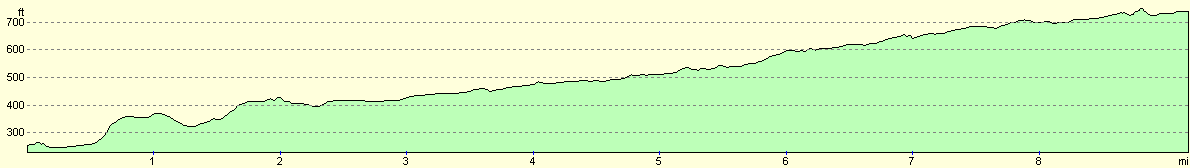
For more information on profiles, ascents and descents, see this page
Accommodation
I stayed at Hazelbrae House, Garve, Ross-Shsire, IV23 2PX, telephone (01997) 414382. It cost seventeen pounds for the room. This was a truly excellent B&B and the couple owning it made me feel incredibly welcome, which is one of the reasons that I spent two nights here. This B&B would make an excellent place to stay to take advantage of all the local munros, and the couple who run it are very walker-friendly.
Disclaimer
Please note that I take no responsibility for anything that may happen when following these directions. If you intend to follow this route, then please use the relevant maps and check the route out before you go out. As always when walking, use common sense and you should be fine.
If you find any information on any of these routes that is inaccurate, or you wish to add anything, then please email me.
All images on this site are © of the author. Any reproduction, retransmissions, or republication of all or part of any document found on this site is expressly prohibited, unless the author has explicitly granted its prior written consent to so reproduce, retransmit, or republish the material. All other rights reserved.
Although this site includes links providing convenient direct access to other Internet sites, I do not endorse, approve, certify or make warranties or representations as to the accuracy of the information on these sites.
And finally, enjoy your walking!
This walk was mentioned in the following routes:
| My sectional Land's End to John O'Groats walk |
Nearby walks
| # | Title | Walk length (miles) |
|---|---|---|
| 193 | Beauly to Garve | 16.4 |
|
|

|