Walk #196: Croick Church to Oykel Bridge
 |
 |
|
General Data
| Date Walked | 01/05/2002 |
| County | Highlands |
| Start Location | Croick Church |
| End Location | Oykel Bridge |
| Start time | 08.25 |
| End time | 12.51 |
| Distance | 10.7 miles |
| Description | This walk was a long trudge along some muddy and boggy tracks. The last part of the walk had some breathtaking views over some snowy summits. |
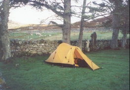
| Pack | Full pack with five days food (I did not cook anything last night so I did not use any food up). |
| Condition | I am fairly tired after this relatively short walk, and I am very glad that it was so short. The chaffing between my thighs is still hurting at times, although hopefully a nice warm bath tonight will help with that. My shoulders and back are both fine, although these have not bothered me for many days now. My feet ache, and this is not made better by the fact that both my feet got wet. My right knee hurt considerably on the little ascent along the track, which was annoying and slightly worrying ten days after my fall. |
| Weather | The day started off with a mixture of sunshine and cloud after a wet night, which allowed me to take my tent down and look around the church without getting wet. Within twenty minutes of starting out is started to rain heavily enough for me to stop to put my coat on, and after twenty minutes it stopped. The day then became brighter, with occasional showers spoiling some lovely sunny periods. The temperature was okay (although cold early on) and the wind was thankfully not very strong. |
| OS map | Landranger number 16 (Lairg & Loch Shin, Loch Naver) and Landranger number 20 (Beinn Dearg & Loch Broom, Ben Wyvis) |
 |
Map of the walk
Maps courtesy of Google Maps. Route for indicative purposes only, and may have been plotted after the walk. Please let me have comments on what you think of this new format. For a detailed table of timings for this walk, please see the table file.
Notes
I was expecting this walk to be easy as it looked very straight forward on the map. Unfortunately I found it to be a very hard walk, which was probably due to both the fact that I was tired after yesterdays walk and that the route was very wet and muddy underfoot. That having been said, it did have some high points and was therefore not as bad as it could have been.
When I got to the hotel I ordered a small meal, a pint of bitter and a cup of tea. A bed and breakfast room costs forty nine pounds, and this was more than I was really willing to pay. I had a chat with the woman running the hotel mentioned the charity and she left me have the room for thirty pounds. This is a very kind act, and made up my mind not to continue on to a camping place, a course of action that I was loathe to do as I was tired.
I spent some time before I set off this morning exploring the church. It is a very emotive place, and I found myself curiously saddened by he story told within. They had a prayer tree, so I wrote a prayer down on a leaf and placed it for pinning up. I then went to the eastern window and tried to discern the scrawls written there; I managed with some but I had to use the guide inside to see the others. And as I thought about it a strange sensation came over me; I was ashamed to be English. Never before have I felt like this and I hope that I never will again, for the sins of ancestors should not readily rest on the shoulders of the young.
I found out today that some of the stitching on my left boot has gone, which could explain why my left foot has been getting wetter than my right one. This is a bit of a blow, as it looks as if more of the stitching could go at any time. I will have to make do until the end of the walk, but it could well make things more uncomfortable than the already are.
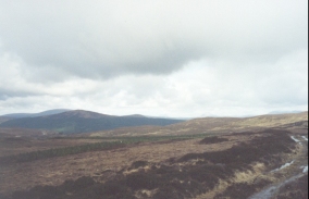
There was a real 'wow!' moment on this walk. As I approached the summit of the path a vista of snow-capped mountains became visible in the distance to the north. It was as though God has sculpted the mountains out of chocolate cake and sprinkled the tops with a light coating of sugar. They looked really majestic, and I found it depressing as I dropped down along the forestry tracks and they slowly went out of view behind the intervening hills.
Some of the tracks today were very muddy indeed, and this made progress quite slow in places. At times the tracks consisted of nothing but two wheel ruts and the area in between covered in water, and this was occurring every twenty or so yards.
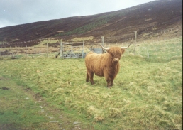
Whilst walking along the track I came across a herd of hairy cows (or hairy coos as my girlfriend likes to call them). One was on the track, and stayed there staring at me whilst the others fled towards the river. It seemed to be posing for a photograph so I got my camera out and duly obliged it. I do hope it turns out well, as Sam does love her hairy coos!
The Bridge of Oykel is actually two bridges with an earlier hump-backed bridge behind the modern one. The road that it carries is exceedingly quiet for a main road, although it may get busier later on in the summer during the tourist season. The River Oykel which runs underneath the bridges, and the River Einig which was followed for a short distance today, are both fairly spectacular rivers, and as I stood watching the waters flow I could almost imagine seeing the salmon swim upstream.
I may try and make for Inchnadamph tomorrow, which is eighteen or nineteen miles away following the road. I am very tempted to do the route mentioned in 'North to the Cape', but I am worried about, amongst other things, my knee and how that will hold up to lots of ascent over rough ground. I am currently two days ahead of schedule and if I get to Inchnadamph tomorrow I will be three days ahead;this could prove to be very handy nearer the end of the walk. The weather forecast for tomorrow is for it to be fairish with possible occasional showers, so it looks as though it will be a good day for a long walk.
Directions
This walk starts off at the church at Croick, which is at the end of a long public road which leads up Strathcarron. Turn left past the church and walk westwards for a few hundred yards to a gate beside a farmhouse, where the road end.
Go through the gate and continue north-westwards along the good track, which runs above the northern bank of the Abhainn an t-Srath Chuileannaich. After about four miles and several gates the track passes a steel shed and hen the farmhouse at Lubachoinich. A gate leads through from the front of the farmhouse onto the track again, which is noticeably rougher.
The path slowly starts to turn from a north-westerly to a westerly heading and becomes fairly indistinct on the ground, the most noticeable feature being the wheel ruts. Shortly before a bridge over the river is reached it turns to the right to head north-westwards uphill. Again the quality of the track deteriorates, and frequent boggy patches have to be negotiated with care.
Near the top of the climb at about 230 metres there are some marvellous views are available of mountains to the north. As these become visible the track swings to the left to head westwards. A stream is crossed, and shortly after this a good track made of stone comes in from the left. Join this track as it skirts the northern side of the Allt a' Guial and starts to descend through forestry land towards the valley that carries the river Einig. The stone track, although hard on the feet, is a welcome change to the boggy track.
Various minor tracks lead off from the stone track, but the latter eventually ends at a T-junction with another stone track. Turn right and follow this track eastwards for a short distance to a bridge over the Allt a' Guial. The stone track then rises for a short distance before starting the long descent north-eastwards to meet the Rive Einig at a bridge.
Cross over the bridge to reach the northern side of the river. Turn right and follow the track for a short distance as it heads towards some houses. At the houses he stone track ends and becomes surfaced. This road then swings around to meet the southern bank of the River Oykel which is then followed for about five hundred metres to Oykel Bridge. The hotel is about a hundred yards on the left up the A837.
Distances
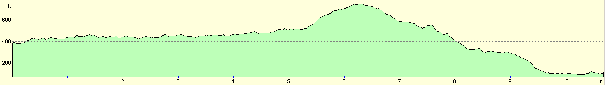
| From | To | Distance (m) | Ascent (ft) | Descent (ft) |
|---|---|---|---|---|
| Croick Church | Lubachoinnich | 3.9 | 381 | 305 |
| Lubachoinnich | NH 370 977 | 3.4 | 381 | 256 |
| NH 370 977 | Bridge of Oykel | 3.4 | 148 | 607 |
This makes a total distance of 10.7 miles, with 910 feet of ascent and 1168 feet of descent.
For more information on profiles, ascents and descents, see this page
Accommodation
I stayed at the Oykel Bridge Hotel, which mainly caters for fishermen, as is shown by all the pictures and fishing gear on the walls.
Disclaimer
Please note that I take no responsibility for anything that may happen when following these directions. If you intend to follow this route, then please use the relevant maps and check the route out before you go out. As always when walking, use common sense and you should be fine.
If you find any information on any of these routes that is inaccurate, or you wish to add anything, then please email me.
All images on this site are © of the author. Any reproduction, retransmissions, or republication of all or part of any document found on this site is expressly prohibited, unless the author has explicitly granted its prior written consent to so reproduce, retransmit, or republish the material. All other rights reserved.
Although this site includes links providing convenient direct access to other Internet sites, I do not endorse, approve, certify or make warranties or representations as to the accuracy of the information on these sites.
And finally, enjoy your walking!
This walk was mentioned in the following routes:
| My sectional Land's End to John O'Groats walk |
Nearby walks
| # | Title | Walk length (miles) |
|---|---|---|
| 195 | Black Bridge to Croick Church | 19.6 |
|
|

|