Walk #822: A circular walk from Four Marks to Ellisfield
 |
 |
|
General Data
| Date Walked | 17/10/2008 |
| County | Hampshire |
| Start Location | Four Marks |
| End Location | Four Marks |
| Start time | 07.56 |
| End time | 16.54 |
| Distance | 23.5 miles |
| Description | This was a pleasant stroll through central Hampshire, using a combination of green lanes and roads. |
| Pack | Today I carried my 30-litre Karrimor rucksack, filled with waterproofs, a book and other odds and ends. |
| Condition | I am fairly fine after this walk; I had no trouble with the ankle that I twisted a couple of months ago, and my feet were also mostly fine. |
| Weather | The day started off cold, with the first frost of the year, but as the day progressed it started to get warmer. Evrntually it was a good day for the time of year, with only the slightest of breezes to chill me. |
| OS map | Landranger number 185 (Winchester & Basingstoke, Andover & Romsey) and Landranger number 186 (Aldershot & Guildford, Camberley & Haslemere) |
 |
 |
|
 |
 |
|
Map of the walk
Maps courtesy of Google Maps. Route for indicative purposes only, and may have been plotted after the walk. Please let me have comments on what you think of this new format. For a detailed table of timings for this walk, please see the table file.
 |
 |
|
 |
 |
|
Notes
I had planned for my next walk to be in Dorset, near to my previous walk. This morning, however, I fancied something a little different, so I picked out this pre-planned walk in Hampshire. The drive did not take me too long, and it was easy to find a free car park situated behind a petrol station in Four Marks. I nipped into the petrol station to buy a few provisions, then headed back to my car to get ready. It was the first time that I had to defrost my car this autumn, but the day promised to be fairly sunny.
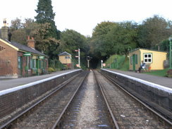
Lots of schoolchildren were heading up to the main road to get their buses to school as I headed down towards the railway station, now part of the preserved Mid-Hants Railway. Although there was a barrow crossing across the tracks I climbed the footbridge to get some views. The station is very well preserved with lots of period character - enamelled signs and immaculate paintwork everywhere. Sadly there were no engines visible, but a road-rail digger (one with both road wheels and railway wheels) and a wickham trolley were in the yard.
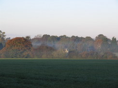
On the northern side of the railway there was an old shed, still with some rails (disconnected from the main railway) heading into it. A track led onwards, and the remains of some fog was still hanging around in the air. In a field to the right there was a hare, sitting perfectly stationary on the frosty grass, wreathed in fog. It was staring up the hill, and paid absolutely no attention to me as I walked past. The track led onto a road, which took me up to the entrance to Chawton Park Wood.
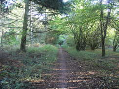
After passing through the car park I joined a track that led along the southern edge of the forest; the track was boggy in place (something that would become a trend on this walk), so I used a little path that ran parallel to it. It was still fairly cold, and the sun was finding it hard to break through the curtain of trees that surrounded the path. A bungalow was passed, and then on the left a small motor-racing track became visible through the trees. Through another gap I could see a couple of hot-air balloons floating to the southeast.
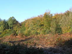
The walk through the woods was fairly enjoyable despite the dark and gloomy atmosphere, and it felt like a shame when the path emerged out onto a road. A track took me up towards Chawton Park Farm, where there were some deer on the hillside to the right, barricaded off by high fences. A signboard gave up-to-date information on what was going on at the farm, which was a very nice touch that was much appreciated.
The surfaced road ended and a track continued on, passing more deer on the hillside before plunging back into the woods. There had been some clearance work done here, and the young trees had not grown high enough to make the track feel enclosed. Underfoot the track was good, and a cyclists and several sets of joggers ran past me - I had seen no-one on the earlier stretch of track along the other edge of the forest.
Just before I reached the point where I left the forest, I heard a rustling in the vegetation off to my right. A fox jumped out and ran towards me; when it saw me it turned ninety degrees and bounded into the vegetation on the other side of the track. A second later a dog ran out, and it too ran across the track after the fox. I had never seen this before; without falling into the trap of anthropomorphising the fox, I would say that it looked terrified.
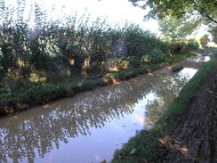
What followed were a series of tracks that room me in a rough northeasterly direction; Jennie Green Lane was followed by the aptly-named Dirty Lane. In several places these were fully flooded, meaning that I had to divert off to one side to avoid the water. Despite this, my left boot got covered in mud whilst scrambling past one section, although fortunately my foot remained dry.
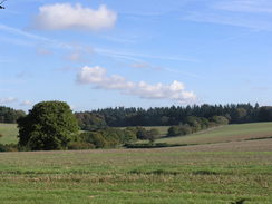
There were some scramble bike riders on the road near Ashley Farm, and I said hello to these before continuing up Bullfield Lane, another green lane. I was to see them three more times during rthe day, as they roared around the local lanes and tracks. As I approached the top of the hill I made a decision; my planned route was to follow the Oxdrove Way northwestwards, but instead I decided to go northeastwards instead. There were several reasons for this change; the planned route got rather close to my return path, and this change would make the path more circular; and also I like to be able to get twelve miles done before midday. I had not achieved this so far this year, although I did it many times towards the end of last year. Taking the new route would give me a bit more road walking, where I would be able to set a good pace.
A short section of track took me to a road near Tickley, and I followed this northwards past Burkham. There was not much to see on this stretch of road and the traffic was light, so I just concentrated on listening to a Podcastle fantasy story podcast. More tracks took me downhill, before the heavily-rutted Kit Lane led me uphill into Ellisfield. The ruts were quite deep - a couple of feet in places - but the ground was dry, meaning that they did not impede progress.
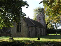
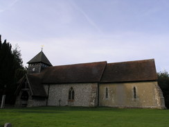
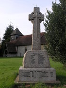
At this point I passed midday, and I was pleased to see that I had done a little over twelve miles - about a fifth of a mile over the target. This was very pleasing, particularly as I had virtually no aches or pains. This was a vast improvement to the last walk, where I had been suffering from very early on in the day A series of roads took me on past the pretty little Ellisfield church, shortly after which I reached the northernmost point of the day's stroll.
There was a pub marked on the map, and I was hoping that it would be open. You cannot always guarantee this - many pubs marked on Ordnance Survey maps have closed since the map was printed - but fortunately the cars parked outside indicated that this one was open. A man was trimming some vegetation on the walls, and a few small grapes lay on the ground as I removed my muddy boots. It was surprisingly busy inside, I guess that the pub attracts people from the surrounding area for lunches. I ordered a pint of orange and lemonade and another of 6X.
Ordinarily I do not eat a large meal if I am on a walk, a packet of crisps will do me. But a couple were eating what looked like some lovely food, so on the spur of the moment I ordered a meal - sausages and chips, before going to sit down. I was aware that my trousers were slightly muddy and that I was probably a little smelly, so I went and sat down on a corner table away from everyone else.
The food came promptly, and it tasted delicious - the sausages in particular were superb. I was fairly famished and so I wolfed it all down, not even giving myself time to read the book that I had stuffed in my rucksack for just such an eventuality. I had not realised that I was quite so hungry, although good food tends to help my appetite.
Eventually it came time to go, and I put my boots on before heading off down the road. As usual my feet ached once I set off - this is particularly the case when I take my boots off - so I took the first half-mile slowly, only speeding up once I reached another road junction.
A series of roads took me southwards, passing Southwood Farm before joining another track. The first stretch of this was exceptionally waterlogged, indeed, it looked more like a linear swimming pool than a track. I squeezed past on the verge on the right-hand side until a bush was reached, and I had to grab onto this and swing myself around it to reach the other side. It was a difficult manoeuvre, but fortunately my feet did not get wet. Soon the track started track start rising yet again, running between hedges before bursting out into an open field at the top of the hill. Another little descent followed, and then the track ended at a road.
More road walking followed as I headed in towards the little village of Upper Wield. Near the end the road became slightly narrower, and I stepped onto the verge to allow a couple of lorries past. I waited for a red van to go past, and as it went past the man shouted 'Ahhhh!' at the top of his voice through his open window. It caused me to jump, and I swore at the driver as he sped off. What an absolute git.
In Upper Wield I joined a little stretch of route that I had walked before, heading through the pretty little village and heading out the other side. Soon I left the road, and joined a track that passed a farm. Some people were dismantling a large shed, and were scrambling over the roof removing the corrugated iron sheets. As I watched them one of them shouted out, asking if I was health and safety; I responded that I was not, and that I had done enough demolition of roofs myself!
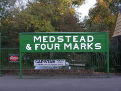
The track soon became a narrow path between hedges, before reaching a track that led past a large shed. This track then led onto a road, which I followed all the way into Medstead. This small village was surprisingly bustling, with lots of people about, mainly mothers with their children. A shops seemed to be selling all sorts of odds and ends, but I was too keen to finish to drop in.
By this time I was starting to get a little tired, and the last road stretch was quite hard on my feet, although they were nowhere near as bad as they had been after last week's walk. There were not many views to be had, and I just out my head down and strolled along. It was a relief when I reached the road that I had followed earlier, and then the track that led down to the railway station in Four Marks. I crossed the barrow crossing and headed up the road.
On the other side of the A31 there were a bunch of teenagers, and I got some strange looks as I walked past them; I did not care. I had expected it to take me some time to get match-fit after such a long lay-off from walking, but I have now managed two 23+ mile walks in a row. True, they were not hilly walks, but I have no doubt that will come. As I unlocked my car I felt quite elated; it was hardly a classic walk, but it served its purpose. My ankle is healing nicely.
 |
 |
|
 |
 |
|
Directions
This walk starts off from the public car park just to the south of the A31 in Four Marks. Leave the car park and turn left to walk past a petrol station to reach the A31. Carefully cross the road (there is a pedestrian crossing a few yards away on the right), then walk down the station approach northwards to reach Four Marks station. If trains are running cross the footbridge over the lines, otherwise there is a barrow crossing that can be used. On the other side turn slightly to the right to follow a lane that heads slightly west of north for a little over half a mile until it ends at Five Ash Road.
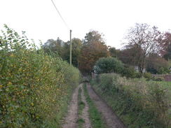
Turn right along the road and follow it as it climbs uphill to the east. When it finally curves sharply to the right cross a lay-by and enter a car park in Chewton Park Wood. Keep the hedge on the right as you walk though the car park, and at the end squeeze through a gap in the hedge, turn right, then left and join a track that heads eastwards through the trees. The main track is fairly boggy in place, but there is a narrow path through the trees on the left that is easier to walk along.
After about a mile a bungalow is passed on the left; continue straight on along the track as it heads northeastwards, still skirting the southern edge of the woodland. Eventually it passes a house on the left and then reaches a bend in a road. Here turn left to follow a surfaced track that heads slightly south of westwards, passing the same house on the left. This reaches Chewton Park Farm, and here the tarmac ends and a gravel track continues on. The track becomes rougher as it enters Chewton Park Wood and takes a more westerly course. When a crossroads in the tracks is reached nearer the western end of the woodland (there is a fingerpost denoting the junction), turn right to head uphill to the north along a bridleway.
This bridleway emerges out from the woodland and continues northwards, soon joining a surfaced track that ends at a road. Cross the road, and on the other side join Jennie Green Lane. Follow this as it heads northwestwards for a little over a mile until it reaches Trinity Road. Cross the road, and then head on for over half a mile until a complex junction in tracks is reached. Turn right to start heading northwards along a track called Dirty Lane.
This crosses Ashley Road, and another track, called Bullfield Lane, continues on northwards. At another complex junction in the tracks turn right, passing Rushmoor Pond on the right, and follow a track that heads northeastwards through trees. This track ends at a road; turn left and follow this road as it heads northwards, passing through Tickley and Burkham before it ends at a T-junction with Spain Lane. Turn left and follow this road northwestwards until it ends at a T-junction with another road.
Turn right along this road for a few yards, then turn left to join another bridleway that heads westwards for a hundred yards. When trees start on the right, turn right along another bridleway that heads downhill to the north, with woodland on the left and open fields on the right. This soon ends at a road at the bottom of the hill, cross the road and continue uphill to the north along a track called Kit Lane. This is heavily rutted at heads uphill, but becomes smoother as the gradient slackens before it ends at Bell Lane.
Turn left along Bell Lane; when this reaches a T-junction turn right along another road, then take the first road off to the left, Church Lane. Follow this road as it heads northwestwards, passing Ellisfield church on the left before a triangular road junction is reached. At this junction turn left and follow Green Lane as it heads southwestwards, slowly curving to the left to pass The Fox Pub. From here the road continues southwards until it ends at a crossroads.
Continue straight on along another road that climbs steeply uphill to the south through some woodland. This approaches Southwood Farm, then curves sharply to the left to continue in a rough southerly direction before ending at another crossroads. Turn right to head westwards along this road for a short distance, and as the road curves to the right turn left to head down a track. Initially this heads southwestwards with hedges close-by on either side, before it opens up into fields as it rises and falls to end at a road.
Turn left to head southeastwards down this road for a couple of hundred yards until a road junction is reaches near Down Farm Dairy, then turn right to head south down another road. Continue on along this road as it twists and turns, eventually entering the village of Upper Wield. Head through the village until a T-junction is reached. Here turn right, and follow the road as it immediately curves around to the left to head southwards, descending down to reach another junction at Battle Corner.
Turn right along this road for a few yards, then immediately after a farm turn left down a track. This heads southeastwards, as the track curves away to the right turn left to join a footpath that squeezes between hedges, heading towards a barn in the distance. Just before the barn is reached the path joins a surfaced track that continues on southeastwards before ending at a road in Hattingley. Turn left and follow this road as it curves to the left to head northeastwards before it ends at a T-junction with Wield Road.
Turn right and follow this road as it heads eastwards into the village of Medstead. Follow the road as it passes the church on the left, then the post office and village shop. At the southeastern side of the village there is a complex road junction; ignore the first road off to the right and take the second, called Roe Down Road. This passes a small recreation ground and continues on southeastwards before it eventually ends at a T-junction with Five Ash Road.
From here it is simply a case of retracing the first mile of the walk from earlier in the day; turn right along the road for a few yards, then turn left down a track that leads to the station. Again either cross the footbridge or the barrow crossing, and continue southwards along the road to reach the A31 road. The car park where this walk starts is a short distance away on the other side of the road.
Distances
| From | To | Distance (m) | Ascent (ft) | Descent (ft) |
|---|---|---|---|---|
| Four Marks | Ellisfield | 13.2 | 863 | 935 |
| Ellisfield | Upper Wield | 6.2 | 495 | 522 |
| Upper Wield | Four Marks | 4.1 | 230 | 131 |
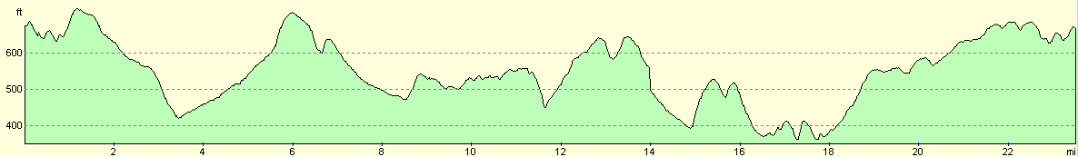
This makes a total distance of 23.5 miles, with 1588 feet of ascent and 1588 feet of descent.
For more information on profiles, ascents and descents, see this page
 |
 |
|
Disclaimer
Please note that I take no responsibility for anything that may happen when following these directions. If you intend to follow this route, then please use the relevant maps and check the route out before you go out. As always when walking, use common sense and you should be fine.
If you find any information on any of these routes that is inaccurate, or you wish to add anything, then please email me.
All images on this site are © of the author. Any reproduction, retransmissions, or republication of all or part of any document found on this site is expressly prohibited, unless the author has explicitly granted its prior written consent to so reproduce, retransmit, or republish the material. All other rights reserved.
Although this site includes links providing convenient direct access to other Internet sites, I do not endorse, approve, certify or make warranties or representations as to the accuracy of the information on these sites.
And finally, enjoy your walking!
Nearby walks
| # | Title | Walk length (miles) |
|---|---|---|
| 798 | A circular walk from Litchfield | 24.1 |
| 812 | A circular walk from North Waltham | 22.9 |
| 813 | A circular walk from Alresford | 24.0 |
|
|

|