Walk #821: A circular walk from Bere Regis to Milton Abbas and Tolpuddle
 |
 |
|
General Data
| Date Walked | 09/10/2008 |
| County | Dorset |
| Start Location | Bere Regis |
| End Location | Bere Regis |
| Start time | 08.07 |
| End time | 18.09 |
| Distance | 24.5 miles |
| Description | This was a long circular walk through a picturesque and historic part of Dorset, following a combination of footpaths, bridleways and roads. |
| Pack | Today I carried my 30-litre Karrimor rucksack, filled with waterproofs, a book and other odds and ends. |
| Condition | I had trouble with the ankle that I damaged a few months ago, and with my feet, which had softened up over my enforced break from walking. Indeed, I felt worse at the end of this long walk than I have for many walks - the last few miles were really a struggle. |
| Weather | The day started of foggy, with scarcely a cloud in the sky. The fog soon lifted, leaving a fairly warm and windless day. All in all it was a lovely day for a stroll. |
| OS map | Landranger number 194 (Dorchester & Weymouth, Cerne Abbas & Bere Regis) |
 |
 |
|
 |
 |
|
Map of the walk
Maps courtesy of Google Maps. Route for indicative purposes only, and may have been plotted after the walk. Please let me have comments on what you think of this new format. For a detailed table of timings for this walk, please see the table file.
 |
 |
|
 |
 |
|
Notes
It had been a couple of months since my last walk, due to an injury to my ankle that I had suffered a while before. Five weeks of physiotherapy showed it to be in a better condition, and I got the all clear to do another walk. I was therefore quite nervous as I drove west to start this walk. My ankle had given a couple of twinges the night before, and I was far from sure of being able to start the walk, yet along complete what I thought was a 22-mile stroll.
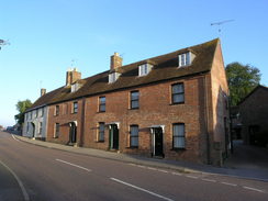
It took me some time to find the car park in Bere Regis, which is situated in the middle of a housing estate near the church. This was the first walk that I had driven to in my new car, and I parked it near the recycling bins before getting my kit together for the walk. My boots had nicely warmed up in the footwell of the passenger seat, but as they went onto my feet there was another twinge of pain. This was not a good sign.
A road took me downhill, then alongside a stream for a period before heading uphill towards the village pub. Soon afterwards the car park became visible a few yards away on the left; I had taken a big, unnecessary loop through the village to end up near to where I had started! Annoyed at this, I headed on to a post office to buy a few provisions. All the time my right ankle was complaining, so much so that I was tempted to call the walk off for the day.
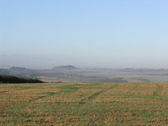
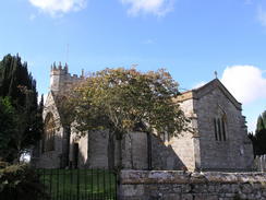
Instead I plodded on. Bere Regis has some pretty buildings in it, and I took a few photographs before joining the Jubilee Way, which headed northwards out of the village to reach the A35(T). This road was very busy, and it took me a few minutes to find a gap in the traffic in order to cross it. On the other side a green lane took me northwards, and as it climbed the views expanded out. To west and east there were valleys filled with fog, although above me the sun shine brightly.
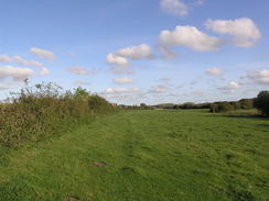
After passing a mast the track descended down onto Bere Down, before heading past the grassy mound of a tumulus to approach a farm. The track passed two sides of a field, and a herd of cows noisily followed me on the other side of the fence - it was obviously near feeding or milking time.
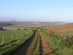
The Jubilee Trail took me northwestwards along a series of field boundaries, and I settled down to listen to a series of EscapePod science fiction podcasts as I strolled along. These are generally very entertaining, and it would have been good to have had them available when I did my year-long walk back in 2002/3. I would like to think that I have an inquisitive, imaginative mind, and the ready availability of free podcasts can make walks much more enjoyable.
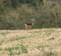
The trail crossed the A354 road, and then headed northwards. Near Deverel Down I saw a deer; it was watching me with grass hanging out of its mouth as I in turn watched it. The stand-off lasted for a minute, during which time I managed to get a couple of distant shots of it off. When I tried to walk onwards it bounded away, jumping high in the air as it headed away from me. At the corner of the next field I went slightly wrong, heading to far to the west towards Bagber Farm, before realising the mistake and crossing a field to rejoin the path proper. It is surprising how easy it is to make such mistakes; a moment's inattentiveness at a stile can easily send you off in the wrong direction.
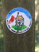
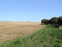
I found the stretch north to Milton Abbas to be fairly boring, the path following a series of paths and tracks as it rose and fell, with no really significant gradients. Eventually Luccombe Hill was reached, and the path entered some woodland before descending down steeply into Milton Abbas. At the top of the hill was a round waymarker for a local path. The marker had obviously been designed by schoolchildren, and was a riot of colours and shapes.
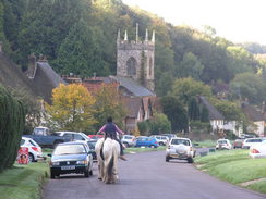
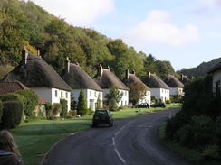
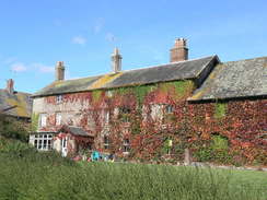
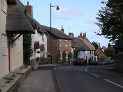
Earlier in the year I had walked through Milton Abbas on another walk, and I found the village to be sublimely beautiful. On this occasion, however, it seemed less so. It was earlier in the day and the sun was lower in the sky ahead of me, but I think that the main problem was mental attitude. My ankle was still twinging, and the occasional discomfort was worrying. Despite this, the white cottages and thatched roofs set aside from the wide main street was still an enchanting sight, especially as a couple of horse were being led down the road in front of me. Yet again this proved my old adage that I could walk through a place on two separate occasions and have two very different opinions of them, depending on weather, mood and so on.
After Milton Abbas a road led uphill towards Fishmore Hill Farm. From here the plan had been to head southwestwards along a series if bridleways, but due to the problems with my ankle it seemed wiser to continue along the road for a while. This soon ended, and more bridleways took me southwestwards, past a very complex junction of tracks at Gallows Corner.
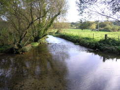
The track emerged out onto a hillside above Dewlish Mill, and it proved slightly difficult to find the proper route down. Fortunately off to my left there was a man walking his dog, and so I simply followed them downhill, to the stream that ran along the bottom of the small valley. This was called Devil's Brook, and I wondered if it had any connection with the Gallow's Corner that I had passed a short time before.
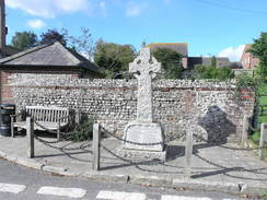
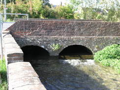
A footbridge led over the brook, and then a road took me south into Dewlish. The war memorial in the village was a pretty carved stone cross, and a short distance beyond this was the pub, called the 'Oak at Dewlish'. This was open, so I nipped in, ordering a pint of bitter and another of orange and lemonade. By this point my boots and socks were totally soaked from having walked through the long dew-laden grass earlier in the day. I took my boots off before entering, and then when I sat down I took my socks off. Fortunately I had a spare pair in my rucksack, so I let my feet dry off for a while.
There was a problem with the little toenail on my left foot, which was becoming slightly detached from the foot. Such problems were to be expected after such a long lay-off from walking, but I soon discovered that I had left my medical kit at home, along with all my plasters, compeeds and other such kit. My plan to wrap up my toes in zinc oxide tape had to be abandoned, and the toenail complained as I carefully pulled the dry socks over my foot.
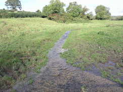
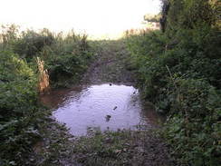
A road took me up westwards over Whitelands Down, and then another track started climbing uphill to the west. My feet were aching by this time, although unfortunately the ankle was no longer giving me any bother. There were no real views to be spoken of, and it turned out to be a bit of a long trudge until eventually the track ended by the eastern edge of Dole's Hill Plantation. There was a stream to be crossed here, and I had to ford this with care. It was wide and there was little choice but to put one boot in the middle, but fortunately my feet did not get wet again.
The track south through the trees was very muddy in places, and it was a relief when the bridleway broke out of the trees. Unfortunately a short distance on the stream had to be forded once more, but this time a clay pipe in the middle gave me a firm footing as I jumped across. The path continued on southwards, eventually becoming a track as it approached Druce Farm and the B3142 road. The walk east along the B3142 had to be taken carefully; it was not too busy, but the verges were non-existent in places. It was a relief when it broadened out a little and the noise of the A35(T) started to dominate everything.
The map showed a footbridge over the dual carriageway, and as I approached a herd of cows was being driven across. A handy ramp led up onto the bridge, and I stopped on top to take a few photographs. My plan had been to walk through the farm on the southern side of the bridge, but a signpost said no right if way. Instead I descended down to a stretch of old road, the white lines still visible in the middle despite the vegetation that was encroaching from either side. This led me on into the village of Puddletown. It was tempting to nip into the village pub for a rest, but time was pressing, and I was starting to realise that my estimate for the distance to be walked was significantly off.
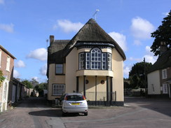
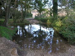
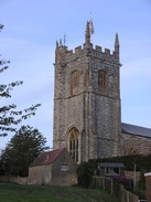
Puddletown was quite an attractive little village, particularly the church and some of the houses. A stream, somewhat amusingly called the River Piddle, ran through the centre of the town. The water was exceptionally clear and glinted in the sunshine. A road took me eastwards from Pudletown, passing the entrance to Athelhampton House on the left and then entering Burleston. Again I listened to podcasts as the walk was fairly uninteresting, and soon I found myself entering Tolpuddle.
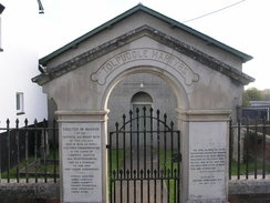
The first buildings on the left housed the TUC Memorial Cottages Museum, commemorating the Tolpuddle Martys, a group of six men who were convicted in 1834 and transported to Australia. Their crime, if it can be called such, was belonging to what is now seen as a precursor to a trade union. The museum commemorates the lives of the six men, although unfortunately it was shut as I passed, due to a burst water main. The entire village seems to live on the story of the martyrs, which is perhaps to be expected. It is a small village, and the story remains in the hearts of trade unionists everywhere. There is still an annual festival held in the village, based around the martyrs.
It was tempting to stop off in the pub in Tolpuddle and call a taxi from there, as my feet were in a poor condition by now. Unfortunately the pub was shut, so I was forced to struggle on. A footpath led me across fields; unlike earlier in the day the grass was dry, but by now my feet were aching fairly intensely. Eventually the B3390 is reached; I had planned to take another footpath that heads eastwards from here, but after walking up and down along the road for a couple of minutes I could not find where the path left. I could have searched further, but instead I decided to follow the road. This meant that the walk would be even longer, but road walking seemed to be kinder on my feet.
The road led into Affpuddle, and then on eastwards. I was running out of water, so near East Farm I asked a man if I could fill my water bottle up. He was on crutches as someone cut his hedge, and he kindly showed me where his tap was. Afterwards we chatted to a few minutes; he regularly cycles on a hand-bike, and is planning a trip through Europe, setting off from either St Davids in Wales or Canterbury. He was a fascinating man, and I hope that things go well for him. Years ago a surgeon told me that I would never walk properly again; I thought that diagnosis and more or less won. It is nice to see when people facing worse challenges also fight them.
A road took me on into Briantspuddle, where there were several small, enchanting thatches cottages, but I was too tired to really take any joy out of them. I felt better now that I had drunk some more water on what was a surprisingly warm day, but my feet were still aching. The road led on into the weirdly-named hamlet of Throop, and then a wide track took me on to my final crossing of the River Piddle for the day. A new footbridge led over the river; the old bridge was dumped beside the track a short distance away, slowly being overgrown by vegetation.
Another smaller bridge took me over a tributary, and then I reached a road in the hamlet of Turner's Puddle. There was still a couple of miles to be walked, but finally I felt like I was on the home stretch; the road rose to a junction with another one, then a long ascent northwards followed, heading over a hill before descending down into the outskirts of Bere Regis. By this time I was absolutely exhausted, and the last few hundred yards were exceptionally hard. I doubt that I had ever been quite so relieved to see my car, and as I was taking my rucksack off I glanced at my GPS to find that I had walked well over 24 miles - much further than I had expected, and a good job after such a long lay-off from walking.
 |
 |
|
 |
 |
|
Directions
This walk starts off at the public car park in Bere Regis. Leave the car park and turn right to walk up into the centre of the village. After a few yards the High Street is reached; turn left down this and pass the post office, before turning right up Butt Lane. The next few miles of this walk follows the Jubilee Way; this walk is well signposted. The tarmac soon ends as the path climbs uphill, and then descends down to reach the A35(T).
Cross the A35(T) and then continue on along the track northwards. It slowly climbs uphill, reaching a summit near a mast before slowly starting to descend down onto Bere Down. On Bere Down turn left down a track that heads downhill to the west; this curves to the right and heads towards Bere Down Farm. Just before the farm is reached follow the track as it curves sharply to the left.
A short distance along this track it curves slightly to the left; here turn right and climb uphill westwards across a field. At the top of the field cross a stile, and on the other side turn right and start following another footpath northwestwards with a hedge on the right. Eventually it turns to the right slightly to head northwards. As it approaches the cottage at Longmead it becomes a track, which is followed up as far as the A354 road.
Cross the A354, turn right and then almost immediately left to continue on northwards along the Jubilee Trail. Walk along with the hedge a short distance away to the left; a small patch of trees is passed on the right. At the northwestern corner of the field cross through a stile and then turn right, to head northwards with a hedge on the right. The path heads across another stile and then enters a small band of trees. On the other side of the trees continue on downhill, and then a track heads uphill, still heading northwards.
The path heads between West Lulcombe Farm and East Lulcombe Farm, then continues on towards a band of trees on Windmill Clump. Just before the trees are reached turn left, to head northwestwards towards a band of trees. A stile takes the path through into the trees, and then it descends down along a set of steps to reach the road in Milton Abbas.
Turn left and head downhill along the road through Milton Abbas. At a road junction continue straight on and follow the road as it curves around the southern end of the lake before another road junction is reached. Here continue straight on and join a road that heads steeply uphill. At the top this curves to the right and passes Fishmore Hill Farm, it heads northwestwards for a few hundred yards before curving sharply to the left to head southwestwards for about a kilometre.
When the road ends at a T-junction near Long Ash Farm continue straight on along a track that heads southwestwards, before soon reaching a complex junction of six tracks at Gallows Corner. Turn left and then immediately right, to continue on southwestwards along a track. When it cross a stile to emerge out into an open field turn slightly to the left, heading away from the hedge on the right. The path crosses another stile and then descends over rough ground down towards the Devil's Brook. Continue on southwards with the brook on the right until a footbridge is reached near Dewlish Mill. Cross the bridge, and then turn right up a track for a few yards to reach a road. Turn to the left, and start following this road southwards for about a kilometre until the village of Dewlish is reached.
At the crossroads in Dewlish turn right to start following a road uphill to the west. This heads over Whitelands Down, and then curves away to the north as it descends to end at a T-junction with another road. Cross this road, and then take a track that heads uphill to the west. Continue along this track for a couple of kilometres; eventually it opens out a little before reaching a stream immediately to the east of Dole's Hill Plantation. Ford the stream, and then turn left along a track that heads south, just inside the trees.
The path leaves the trees and continues on southwards with a hedge and stream on the left; after a short distance turn left through a gap in the hedge and ford the stream once more. Continue on southwards with the hedge on the right, it climbs and falls before settling on a more level course. The path eventually becomes a track that continues on slightly east of southwards, reaching Druce Farm before ending at a road junction. Do not take the first road off to the left, and instead take the second, the B3142 road, which heads southeastwards.
This road is narrow in places; follow it carefully as it passes a sewage works and turns to the left to skirt the A35(T). Just before a footbridge is reached turn left up a long, grassy ramp that leads up to the northern side of the bridge. Turn tight to cross the road using the bridge, and once on the southern side turn right along a bridleway that heads down a slope for a short distance before ending at an old road. Turn left along this and follow it eastwards until it ends at a T-junction with another road in Puddletown; a pub is a few yards away on the left.
Turn right to head south along this road for a short distance until it crosses a bridge over the River Piddle, then turn left to head eastwards with the river on the left. Follow this road as it curves to the right, and then take the first road off to the left, which heads towards the church. Follow it as it passes the church and then curves to head southwards. At a road junction turn left to start heading eastwards along another road that heads out of the village.
Continue along this road as it heads eastwards through the hamlets of Athelhampton and Burleston, before reaching Tolpuddle. Walk through Tolpuddle, passing the church on the right and the pub on the left, and shortly before the houses end on the right, turn right down a footpath. This heads south towards the river, before turning to the left to head westwards with a hedge on the right. It soon goes through the hedge, and continues on eastwards with the hedge on the right. The path passes a barn on the other side of the hedge, before finally ending at the B3390 road near a cottage.
Turn right and follow the B3390 road as it heads southwestwards into the hamlet of Affpuddle. In the village the road curves to the left to head eastwards; when it curves to the right at East Farm continue straight on along another road. This heads eastwards into the village of Briantspuddle. At a crossroads continue straight on along another road that heads eastwards for about a kilometre into the hamlet of Throop.
When the road curves around to the right continue straight on along a track, which soon curves slightly to the left to reach the River Piddle once more. A footbridge takes you over the river, and then another one leads over a tributary of the river. Immediately after this last bridge a road is reached in Turners Puddle. Turn right and start following this road eastwards along this road for a kilometre; when it ends at a T-junction with another road turn left.
Follow Yearnings' Drove as it climbs uphill northeastwards; at another junction turn left to head north along another road. This slowly descends down into Bere Regis. At the bottom of the hill the road crosses a stream; cross this, then turn left along another road. Head west along this as it heads below the church, then turn right up another road that leads up the car park where this walk started.
Distances
| From | To | Distance (m) | Ascent (ft) | Descent (ft) |
|---|---|---|---|---|
| Bere Regis | Milton Abbas | 7.2 | 814 | 492 |
| Milton Abbas | Dewish | 3.7 | 331 | 495 |
| Dewlish | Puddletown | 6.0 | 410 | 508 |
| Puddletown | Bere Regis | 7.6 | 344 | 404 |
This makes a total distance of 24.5 miles, with 1899 feet of ascent and 1899 feet of descent.
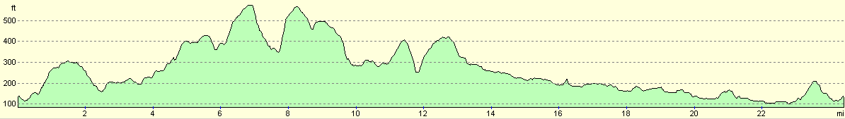
For more information on profiles, ascents and descents, see this page
 |
 |
|
 |
 |
|
 |
 |
|
 |
 |
|
 |
 |
|
Disclaimer
Please note that I take no responsibility for anything that may happen when following these directions. If you intend to follow this route, then please use the relevant maps and check the route out before you go out. As always when walking, use common sense and you should be fine.
If you find any information on any of these routes that is inaccurate, or you wish to add anything, then please email me.
All images on this site are © of the author. Any reproduction, retransmissions, or republication of all or part of any document found on this site is expressly prohibited, unless the author has explicitly granted its prior written consent to so reproduce, retransmit, or republish the material. All other rights reserved.
Although this site includes links providing convenient direct access to other Internet sites, I do not endorse, approve, certify or make warranties or representations as to the accuracy of the information on these sites.
And finally, enjoy your walking!
Nearby walks
| # | Title | Walk length (miles) |
|---|---|---|
| 313 | Hamworthy Station to South Haven Point | 18.0 |
| 810 | A circular walk from Shapwick to Stourpaine | 22.8 |
| 811 | A circular walk from Durweston to Woolland Hill and Milton Abbas | 22.9 |
|
|

|