Walk #811: A circular walk from Durweston to Woolland Hill and Milton Abbas
 |
 |
|
General Data
| Date Walked | 27/02/2008 |
| County | Dorset |
| Start Location | Durweston |
| End Location | Durweston |
| Start time | 08.38 |
| End time | 17.08 |
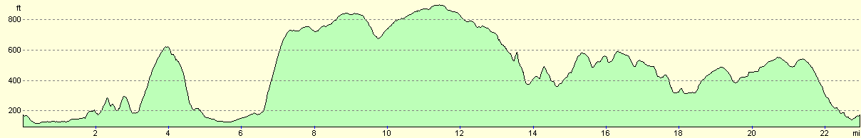
| Distance | 22.9 miles |
| Description | This was a pleasant walk following part of the Wessex Ridgeway and the Stour Valley Way. |
| Pack | Today I carried my 30-litre Karrimor rucksack, filled with waterproofs, a book and other odds and ends. |
| Condition | I feel absolutely fine after this walk. The only problem I had was with a little pain in my left foot, which got cured soon after I changed socks after the lunch stop. |
| Weather | The day started off with hazy cloud high overhead, but this eventually dissipated, leaving mostly a cloudy day with some sunny patches. It was quite warm when in the sun, although the breeze was quite chilly. |
| OS map | Landranger number 194 (Dorchester & Weymouth, Cerne Abbas & Bere Regis) |
 |
 |
|
 |
 |
|
Map of the walk
Maps courtesy of Google Maps. Route for indicative purposes only, and may have been plotted after the walk. Please let me have comments on what you think of this new format. For a detailed table of timings for this walk, please see the table file.
 |
 |
|
 |
 |
|
Notes
Today I decided to walk another stretch of the Wessex Ridgeway, and so I set off early for the drive down into Dorset. It was a longer drive than I expected as I caught the traffic, but eventually I crossed the narrow Durweston Bridge over the River Stour and reached Durweston. There did not seem to be anywhere to park in the village, so I continued northwestwards for a couple of hundred yards along the A357 out of the village until a large lay-by was reached on the left.
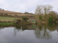
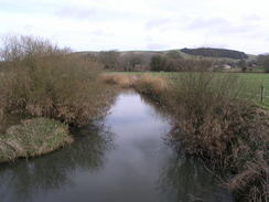
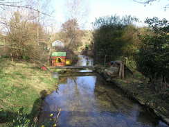
It did not take me long to get my rucksack packed, and I then headed off down the road back into the village, before taking a side road that led past an old mill to reach a bridge over the River Stour. It was a pretty sight, and an iron-tubed footbridge led over the main stream of the river to reach a bridge that led under the old Somerset and Dorset railway line.
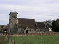
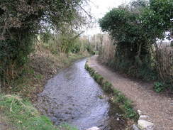
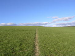
A footpath led across a bumpy field towards the attractive Stourpaine Church. Road led me northwards, and then a footpath headed on out of the village with a stream in company on the right, before the footpath emerged out into a sometimes muddy field. Unfortunately after this I was forced to follow the A350 road as it curved uphill past Bourn Barn. The road was fairly busy and twisting, and I had to carefully walk along the verge.
It was a relief when a bridleway led off to the left climbing uphill to the north. Here I passed a horserider who I chatted to for a couple of minutes. The bridleway descends steeply down into Coombe Bottom, and then follows a track northwards uphill with a long brick and flint wall on the right. From the top of the hill there were some glorious views to the north past Iwerne Courtney, and son the Wessex Ridgeway led off to the left. Instead of turning down this I headed off down into the village. I have yet to walk the Wessex Ridgeway to the north of the village, so I wanted to clamber down to prevent me from having to climb the hill on the next walk.
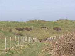
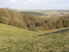
I walked through the village towards the village pub, the Cricketers Pub, which has cricket stumps and ball on the door - a nice touch. Having reached the pub I started to follow the Wessex Ridgeway, climbing back uphill alongside the wall before turning to the right along a track that led westwards onto Hambledon Hill. As it climbed the views became ever more expansive, and from the trig pillar at the top the spectacular ramparts of the hillfort became visible. The views were very good, and I stopped for a few minutes as I let it all sink in.
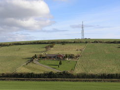
From here the Wessex Ridgeway headed southwards down the hill; I followed the fence down the steep descent, and eventually an enclosed track was reached at the bottom, which led onto a road. A bridleway followed, taking me past Hanford House school and through Hanford Farm. A walk beside the River Stour led to a long footbridge over the river, a very impressive structure that looked as though it had recently been replaced as it was very neat and tidy. A muddy stretch followed as the bridleway headed across a field and joined a track past Holloway Farm and passing under a bridge under the much-lamented Somerset and Dorset railway line. I was surprised to see that the trackbed was clear, and a notice nailed onto a gate told me that it was part of the North Dorset Trailway, a non-contiguous trail I would like to walk in the future.
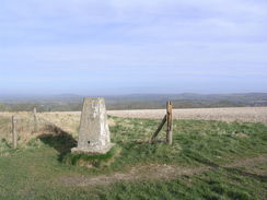
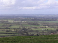
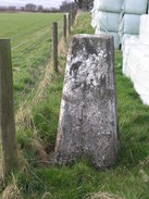
After crossing the A357 a path led on southwestwards to a minor road. Here I found it hard to realise the way, and I walked back and forth three times before eventually deciphering the seemingly conflicting information given to me by the map and the signage on the ground. Needless to say my map-reading abilities were wrong, and I was soon climbing up a track that climbed steeply up Shillingstone Hill through Blandford Forest. About two-thirds of the way up the map showed the Ridgeway bridleway heading off slightly to the right; I could not see this amongst the trees, so I continued up along the track. Once the edge of the trees was reached near the top of the hill it was easy to rejoin the Ridgeway and head to a trig pillar, situated on a broad hedgeless gap between fields. The views from the top should have been nice, but were blocked by the nearby trees.
The track continued on along the top of the hill, with occasional good views through gaps in the trees, before diving through the trees to meet a road by a car park. In a corner of the car park was a small army camp, with a camouflaged tent and some army people around. I had not idea why they were there, and there was no-one too near who I could ask, so I continued on along the track, which climbed slightly as it headed up Bell Hill. In places the views were absolutely superb over the hedge to the northwest.
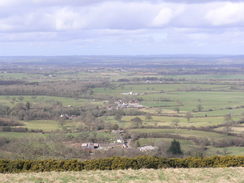
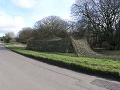
The track descends to join a road, which climbed up Ibberton Hill and then levels off as it heads along Chitcombe Down towards Woolland Hill. Beside a car park on the left there was a stone viewpoint, and unfortunately the metalwork had been stolen off it, leaving it a bare and sorry-looking lump of stone. On the grass at a road junction there was another, larger army tent that was well-camouflaged by netting. Again, I had no idea why they were here; perhaps something to do with the Royal Signals at Blandford Camp?
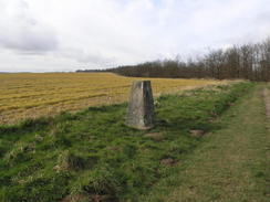
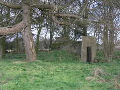
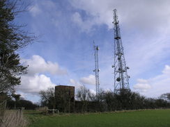
Here I left the Wessex Ridgeway to complete the circular walk back to Durweston. First I walked down the road for a short distance before trying to find the trig pillar on the top of Bulbarrow Hill. This was shown on the map alongside a few radio masts, and I headed through an open gate into a field. The pillar proved easy to find, squeezed between a hedge and a tall pile of plastic-wrapped silage bails, and the gates leading to it were all open. There were a few old, Second World War vintage concrete bunkers and a water tower scattered around amongst the trees, and I wondered if this had anything to do with the Ace High communications system.
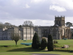
I made my way back to the road and joined a footpath that headed sutheastwards, skirting the western edge of Delcombe Wood. past Bulbarrow Farm there was an attractive little lean-to structure with a seat that appeared to be newly-constructed. The path started off open but with no views, but eventually started heading along a muddy path through trees. A steep descent led down to a road, and from here there were some good views of the fairly spectacular Milton Abbey School and the adjoining abbey, an old Benedictine foundation. A footpath was marked leading down to the abbey, but I was unsure if I could get out on the other side so I followed the road. This climbed up past the school before dropping down to some cottages, where a footpath leading south from the Abbey came in - I could have followed this instead of the linger and far less interesting road walk.
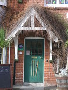
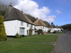
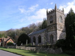
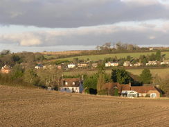
Milton Abbas was a spectacular village - a wide street rising uphill with pretty white-walled, thatched cottages lined up on both sides. Halfway up there is a small stone church on the right, and beyond this was the Hambro Arms pub. This was open so I ordered a pint of bitter and a pint of orange and lemonade, and I sat outside and took my boots off. My left foot had started aching, so I rested whilst I watched workmen come to and fro from their work on the pub.
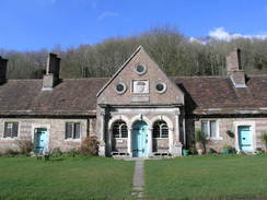
My foot was not much better as I started off once again, hading uphill with a large stone building - almshouses? on the left. It is a truly beautiful village, a really picturesque treat, as can be expected from a village that was created in 1870 when the local landowner moved the population. Like the slightly later Edensor outside Chatsworth, such moved villages tend to be well organised and fit the aesthetics of the time they were built.
After leaving the village a path headed up northeastwards through Milton Park Wood. Here I went slightly wrong; I stayed on a track for too long, and had to cut up through the trees to rejoin the proper path, that skirted the edge of the trees. This part of the walk followed the Jubilee Trail, opened in 1995 to celebrate the sixtieth anniversary of the Rambler's Association. After this the track was easy to follow as it climbed and fell through Charity Wood, before emerging from the trees and crossing fields.
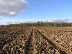
Winterborne Stickland was a slight let-down after Milton Abbas, but it was far from an ugly place, with a trickling stream running through it and more of the white-walled, thatched cottages. A path led out of the village uphill, before reaching the edge of Field Grove. It skirted the woods before reaching a road, where it joins a track that leads through the woods. The rest of the walk was fairly ordinary, and I did not take much of it in as I was tired and my foot was still aching. Folly Barn was a nice structure made of flint and brick, but I barely noticed it as I started the final descent down to Durweston, passing through Sutcombe Wood.
It was a relief when I reached the car, and I could look back on what had been a varied walk, with some superb views and beautiful villages passed through. Dorset is certainly very picturesque in places.
 |
 |
|
 |
 |
|
Directions
This walk starts off at a lay-by on the A357 road, a few hundred yards to the northwest if Durweston village. Turn right and head down the A357 into the village, and then turn left down a track that leads northeastwards to an old mill. Follow the track past the mill as it crosses a stream of the river, and then follow the footpath to a footbridge over another stream of the river. Continue on under an old railway bridge, and then turn left to climb up some steps to join a footpath. This heads between two fences before ending at a road at Stourpaine Church.
Join the road and head north through the village. Continue on until the road curves to the left and ends, and then turn right past a building to join a footpath with a stream beside it. Continue on northwards alongside the stream, and when a track curves uphill to the left climb a stile to enter a field. Head northwards for two-thirds of a mile as it follows the valley follow with a stream to the right. In places the path was muddy.
The footpath passes Bourn Barn and ends at the A350. Turn left along the road and follow it as it curves uphill to the right; the road is narrow and the traffic can be heavy, so be very, very careful during this stretch of the walk. At the top of the hill the road straightens out, and just before it curves to the right to head downhill once more join a footpath on the left. This heads northwards for a short distance to a road; cross the road and follow a bridleway northwards along the edge of a field. At the far end of the field ignore the bridleway that curves to the left to continue climbing and instead go through a stile in the corner of a field to descend downhill through some trees into Coombe Bottom.
At a track turn right to head northwards uphill along a track, with a brick and flint wall on the right. Continue uphill, and follow the path as it descends down to meet a road in the village of Iwerne Courtney. Turn left along this road, and then right down a narrow road that runs along the side of the Cricketer's Pub in the village. From here turn back and head back out of the village the way you came, and then climb halfway back up the hill along the wall, following the Wessex Ridgeway. At a junction in the tracks marked by a large fingerpost, turn right and head westwards along a track uphill for a little over half a mile until the trig pillar is reached at the top of Hambledon Hill.
At the trig pillar turn left and follow a track southwards along the top of the hill. As it skirts the woods at the top of Coombe Bottom turn right and start following a bridleway southwestwards, with a hedge line away to the right. The bridleway descends steeply, and near the bottom of the hill turns sharply to the right to descend down a track through trees for a short distance until it ends at a road. Turn left along this road and follow it southeastwards for a few hundred yards; when there is a junction with a track on the right, turn right and follow the track as it heads towards Hanford House School. The track curves to the left, and then what it approaches the school turn right along a bridleway. This heads westwards for a third of a mile until it reaches the eastern bank of the River Stour.
Turn left and follow the bridleway as it heads south along the river bank until it reaches a bridge over the river. Cross this bridge, and on the other side head west across the field to reach a gate. On the other side of the gate is a track, that can be followed past Holloway Farm, where it becomes a road that reaches the A357 to the south of Shillingstone. Cross the road and take a footpath directly opposite that heads southwestwards along the edge of a field; at the end of the field it curves sharply to the left to end at a road. Turn right along this road for a hundred yards, and when it curves to the right turn left along a track. Initially this heads southeastwards, but at a junction turn right to start ascending up a wide path that heads steeply uphill to the southwest . The path emerges from the trees and continues on south for a short distance across a field until a track is reached; here turn right to walk along the track westwards towards a trig pillar.
Pass the trig pillar by a few yards until a track is reached that runs along the edge of the woodland, and then turn left along this track. Head slightly south of westwards along it, and at a complex junction of paths curves slightly to the right to take a westerly route through the trees, remaining more or less on the level. When a road is reached beside a car park cross it, and continues on along a track on the other side. This heads southwestwards for a mile and a half across Bell Hill, passing a couple of radio masts on the left before ending at a rad. Turn left and follow this road as it falls for a short distance before climbing up Ibberton Hill.
After a mile and a half a road junction is reached on Woolland Hill; here the W4essex Ridgeway is left behind. Continue straight on along a road that heads southwestwards with Delcombe Wood on the left. After a third of a mile turn left down a track that heads southeastwards along the southwestern edge of the wood, passing Bulbarrow Farm before continuing on south of southwestwards for a little over two miles. The path starts off wide and open, but eventually becomes narrow and constrained amongst trees before dropping down steeply through some woodland to end at a road.
Turn left along this road and follow it as it curves around to the right, passing Milton Abbey School and passing Pidgeon House Plantation on the left. Near a lake the road curves to the left and starts climbing uphill through the linear village of Milton Abbas. When this road ends at a T-junction at the top of the village turn left along the road for a short distance, and then turn right along a bridleway, which initially heads eastwards until it reaches the southern edge of Milton Park Wood. There was a track winding through the woods that made navigation difficult; it leaves the track and heads northeastwards uphill, soon leaving the trees and skirting the edge of a field on the left at the top of the hill. It descends down to another track, and then curves to the left and then immediately right to take a more easterly course uphill through Charity Wood.
The path is easy to follow as it settles on a northeasterly course, leaving the trees and crossing a series of fields before ending at a road. Turn right along this road for a few yards, and then turn left along a footpath that heads through trees to reach another road in Winterborne Stickland. Turn right along this road for a short distance, and then turn left along a footpath that climbs uphill, before turning to the right to skirt the edge of a field. The path heads northwards before turning to the right to descend down to a road.
Turn left along this road and follow it northwards for a fifth of a mile Pass a road junction on the right, and then take a footpath that heads off to the right, climbing uphill, slightly east of northwards. At the top of the hill the path curves to the left to head northwards to reach the southern edge of the trees of Field Grove. Turn right and follow a path that runs eastwards along the soutehrn edge of the trees for half a mile, descending down to reach the end of New Road. Turn left along the road for a couple of yards, and then turn left along a track. This heads northwestwards through the trees, soon passing a house on the right as it climbs up a slight hill.
The track emerges from the trees and continues on until a crossroads with another track is reached. Here turn right, and follow a track as it heads eastwards towards Shepherd's Corner Farm. Pass the farm and follow the track as it curves to take a northeasterly course. Past Folly Barn a bridleway leaves the track to the right, heading down a little shallow-sided valley before entering Sutcombe Wood. Continue on the path through the woods, and when it emerges continue on as the fields get smaller before it reaches a track that leads down to the A357 in Durweston. Turn left and follow the A357 northwestwards until the lay-by is reached where the walk started.
 |
 |
|
 |
 |
|
Distances
| From | To | Distance (m) | Ascent (ft) | Descent (ft) |
|---|---|---|---|---|
| Durweston | Iwerne Courtney | 3.1 | 344 | 335 |
| Iwerne Courtney | Bulbarrow Hill | 8.4 | 1503 | 784 |
| Bulbarrow Hill | Milton Abbas | 3.6 | 351 | 801 |
| >Milton Abbas | Durweston | 7.8 | 860 | 1138 |
This makes a total distance of 22.9 miles, with 3058 feet of ascent and 3058 feet of descent.
For more information on profiles, ascents and descents, see this page
 |
 |
|
 |
 |
|
 |
 |
|
 |
 |
|
Disclaimer
Please note that I take no responsibility for anything that may happen when following these directions. If you intend to follow this route, then please use the relevant maps and check the route out before you go out. As always when walking, use common sense and you should be fine.
If you find any information on any of these routes that is inaccurate, or you wish to add anything, then please email me.
All images on this site are © of the author. Any reproduction, retransmissions, or republication of all or part of any document found on this site is expressly prohibited, unless the author has explicitly granted its prior written consent to so reproduce, retransmit, or republish the material. All other rights reserved.
Although this site includes links providing convenient direct access to other Internet sites, I do not endorse, approve, certify or make warranties or representations as to the accuracy of the information on these sites.
And finally, enjoy your walking!
Nearby walks
| # | Title | Walk length (miles) |
|---|---|---|
| 810 | A circular walk from Shapwick to Stourpaine | 22.8 |
| 821 | A circular walk from Bere Regis to Milton Abbas and Tolpuddle | 24.5 |
| 853 | A circular walk from Ludwell to Iwerne Courtney | 23.8 |
|
|

|