Walk #813: A circular walk from Alresford
 |
 |
|
General Data
| Date Walked | 10/04/2008 |
| County | Hampshire |
| Start Location | Alresford |
| End Location | Alresford |
| Start time | 08.07 |
| End time | 17.00 |
| Distance | 24.0 miles |
| Description | This was a pleasant figure-of-eight walk based on the Wayfarer's Walk. |
| Pack | Today I carried my 30-litre Karrimor rucksack, filled with waterproofs, a book and other odds and ends. |
| Condition | I am fairly tired after this walk, but have no other problems. |
| Weather | The day started off sunny with only a few clouds, that soon parted leaving a sunny sky. As the afternoon went on, clouds gathered and there was the threat of rain. |
| OS map | Landranger number 185 (Winchester & Basingstoke, Andover & Romsey) |
 |
 |
|
 |
 |
|
Map of the walk
Maps courtesy of Google Maps. Route for indicative purposes only, and may have been plotted after the walk. Please let me have comments on what you think of this new format. For a detailed table of timings for this walk, please see the table file.
 |
 |
|
 |
 |
|
Notes
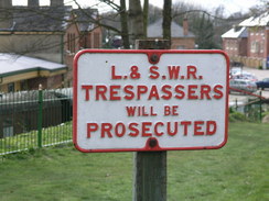
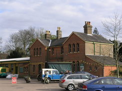
I decided to do another day's walk along the Wayfarer's way today, which would be another circular walk with the majority of the time spent away from the target trail. It took me a surprisingly long time to drive up to Alresford - the traffic on the road towards Winchester was quite busy, and I had a frightening moment when I nearly hit two Muntjac deer on the road near Hursley - I was forced to break heavily, and even then I missed the second deer by what felt like inches. The car park is right by the railway station on the Mid-Hants railway, and it cost a few quid for a ticket for the entire day. Note that at weekends it may cost more to park here. After setting off I stopped at a newsagents to buy a few provisions, and then headed off through the attractive town. It was market day, and many stalls were being set up along the wide road. A lorry driver stopped me at one point and masked me directions, although I had no idea where the place he wanted was.
In Alresford there was a nasty right-hand bend followed by a left-hand bend with no pavement - fortunately it was a 30MPH speed limit and the traffic was light. After this the gradient slackened, and the road headed northwards along a raised causeway with Old Alresford pond on the right and what looked like old Watercress beds on the left, with a concrete and wooden structure still showing. There was no pavement, but the verge on the left was wide, which allowed me to walk with few problems.
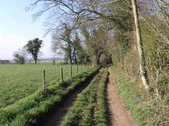
After the causeway the road climbed slightly and a pavcement started on the left, and after passing Old Alresford church (which I could not get any decent photos of due to he angle of the sun) I followed a road past an elegant gateway leading into Old Alresford House. Walls enclosed me on both sides for a short distance as I listened to some EscapePod science fiction podcasts. The road became a lane that was rough but easy to follow as it headed northeastwards, here following the Oxdrove Way. It was a fairly straightforward stroll and I put my head down and just walked until the track ended at a road junction near Newmer Farm. There were some old vehicles by the farm, including an old bus, and a long and boring road walk followed uphill to Upper Wield.
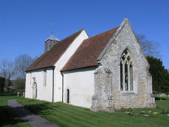
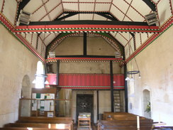
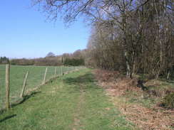
I nipped into Upper Wield church for a while to have a look inside, and it was well with it. Overhead there was an elegant ceiling, and the highlight were traces of old wall paintings that had been uncovered. I looked around for a while, before heading out once more and trying to find the Three Castle Path, which was to take me westwards. This led me past three bands of woodland, and for a while there was some form of orchard or vineyard through a hedge to the left. I listened to a superb Escapepod story as I walked, and this kept me well occupied as I strolled along.
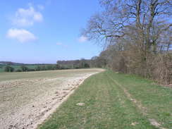
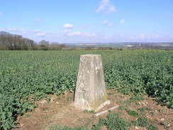
Eventually another track was reached, and where this joined a road on Bugmore Hill I diverted off to visit the trig pillar just off the road. I followed wheel tracks through the young crops to reach it, and admired the views to the north from the pillar. It was a pleasant spot, and I then headed north along the road to meet the path that I had walked along on the previous walk. Again this was the Oxdrove Way, and eventually I reached the Wayfarere's Walk.
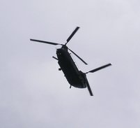
Here I followed a track that climbed uphill, giving good views to the north. This climbed uphill to the south, and was easy to follow as it headed towards the B3046 on Abbotstone Down. On the other side the path headed through some woodland, the path getting narrower as it descended down into Abbotstone. On the way I passed a bunch of people walking with a couple of dogs, the first walkers I had seen during the day. Abbotstone was an unremarkable place, and I was soon climbing uphill along another track as a Chinhook helicopter flew overhead. The next thing of note were some watercress beds, the first that I had ever got a clear view of over some horse jumps.
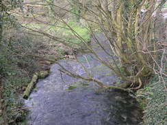
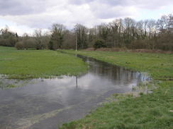
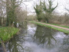
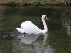
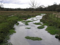
Another climb was followed by a descent that led down to the River Alre, and once the path joined the riverbank it was the most pleasant stretch of the walk. There were a couple of swans swimming around, and although the path was flooded in a couple of places, although only to an inch or two. I found myself wishing that the entire walk could be like that as I left the river and started heading uphill back into Alresford. By this time I was hungry, so I nipped into the first pub I found - the Horse and Groom. I had a lovely meal in here washed down by a pint, but I could not spend too long as I had to head off once more.
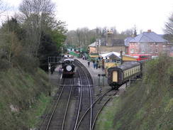
I passed the large church in the town before following a oath that gave me some views towards the railway line, where a steam train was visible in the distance. A climb followed up to a school, and then a descent down to a footbridge over the A31. Once over this the path crossed a golf course on Titchborne Down, and the walk was fairly ordinary until it reached the crossing of the infant River Itchen at Cheriton Mill, where there were some nice views of the tiny river.
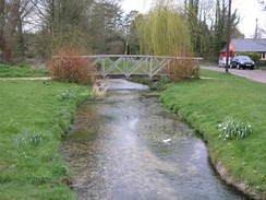
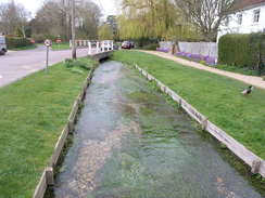
The Wayfarer's Walk headed southwards along the valley to Cheriton, where the river runs in a culvert through the centre of the village. It was a particularly pleasant spot, but I did not have time to stop and so instead I climbed uphill out of the village. I left the wayfarer's Walk about a mile to the east of the village, turning left to follow a track before taking a footpath off to the east before joining another track to take me back towards Laresford. As this climbed uphill I passed the sight of the Civil War Battle of Cheriton in 1644. It was hard to imagine that this quiet spot had been the sight of a battle.
There was a smelly section of track by a sewage farm, after which the track dived into trees that skirted the edge of the golf course before reaching he A31. The bridge over the A31 was a short distance away, and it was then a case of retracing my steps back to the station in Alresford. I was feeling very tired by this point, and the last climb was hard. As I walked along the path past the station there was a steam train passing, and soon I got back to the car in the car park, feeling tired bu very happy after a long day's walk.
 |
 |
|
 |
 |
|
Directions
This walk starts off from the car park outside Alresford station. Leave the station and head north, passing a police station on the right and some public toilets on the left. When a T-junction is reached in the centre of town, turn right and then immediately left to head north along the B3046 road. This road is wide, and follow it northwards as it leaves the village and heads northwards down towards the river. Cross the river, and continue on northwards along the B3046. The road climbs uphill, and immediately after passing Old Alresford church turn right. This road passes the entrance to Old Alresford church on the right, and heads northeastwards.
When the road curves to the right continue straight on along a track that follows the Oxdrove Way along Colden Lane. After about a mile this crosses a road by Nettlebed Farm, and then continues on northeastwards for a little under two miles, when it turn to the left to head northwards and end at a road junction. Head along the road for a few yards to a road junction, and then turn right to head northeastwards past Newmer Farm. A little under half a mile alter a road junction is reached at Battle Corner; here turn left, and follow a road that climbs slightly northwards towards Upper Wield. As it enters the village it turns to the right; as soon as it has done so, turn to the left and then turn left once more, heading for the church.
Head through the churchyard, and on the western side turn left along a track to a field boundary, and then turn right to join the Three Castles Path as it runs westwards. It descends to pass along the northern side of Barton Copse, and then the southern side of Wield Wood, before finally following a hedge and then running along the southern edge of Godsfield Copse. It hen descends down to end at a T-junction with a better-quality track. Turn right along this track and follow it uphill northeastwards onto Bugmore Hill.
When the track ends at a T-junction turn right to head northwards for over half a mile; as the road curves to the right, continue straight on along a road junction. After a few yards turn left to start walking along another track that carries the Oxdrove Way westwards. After three-quarters of a mile the track curves to the right by a farm; at the farm turn left to walk in front of a large barn. Immediately past the farm turn left to join the Wayfarer's Walk as it heads southwards, climbing uphill.
At the top of the hill the track turns to the right beside a band of woodland and then almost immediately to the left, to continue heading southwards. As it turns right to head towards Swarraton Farm, continue straight on along another track that climbs up through some trees, emerging from them to end at the B3046 road on Abbotstone Down. Cross the B3046, and follow a track that heads southwestwards through an area of woodland. In a couple of places the track becomes a narrow path, but if you keep the southern edge of the trees close by to your left you should find the gate out with no problems. Once out of the trees, a track continues on southwestwards for about a mile as it slowly descends. When the end of a road is met near Abbotstone Farm, join the road and follow it as it heads southwestwards to end at a T-junction in Abbotstone.
At the junction turn right and cross a bridge over a river. After a couple of hundred yards there is a complex junction; ignore all of the roads and head straight on along a track that heads uphill to the west. After nearly half a mile a complex junction of tracks are reached; here turn hard-left and start following another track southeastwards. This soon crosses a road; after this continue on as it slowly descends downhill to re-cross the river near some watercress beds.
When the track curves to the left on the other side of the river, turn right and follow another track that heads southwards, and as it climbs it slowly curves to an easterly course. When this track ends at a road, turn left along another road, but soon pull off to the right, to follow a footpath that skirts between the road on the left and the River Alre on the right as it heads northeastwards. The path skirts through some trees, before joining the northern bank of the river. At a building the path crosses onto the southern side of the river and continues on eastwards, eventually climbing up slightly and meeting a surfaced track. Here turn left to continue walking along the same bank of the river. When the end of a road is met, turn right and follow this road as it heads uphill slightly. When it ends at a T-junction, turn right for a few yards to reach the B3046 in Alresford.
Head straight on and follow the B3046 south uphill. When it ends at a T-junction, head straight on down a path that enters the churchyard. Walk past the church on the right, and continue on as the path leaves the churchyard. When it reaches the top of the railway cutting, it turns to the left to follow the cutting for a short distance to a road. Turn right at this road and follow it as it immediately crosses the railway line on a bridge. As it heads southwards the road climbs up a hill, passing a school on the right before dropping downhill. Follow the road as it curves to the right at the bottom of the hill, and then after about a hundred yards take a path that heads uphill to reach a footbridge over the A31 road.
Cross the road, and on the other side carefully follow the Wayfarer's Walk as it crosses the golf course southwestwards. Once across the course it climbs up a slight hill, before entering a band of trees that it follows to the B3046 road. Turn left and follow the B3046 road southwards for a couple of hundred yards; when it curves to the right at Crooked Billet, turn left and follow a green lane called Hinton Lane uphill.
At the top of the hill turn right and descend downhill along Prite Lane. When the B3046 road is reached cross it, and continue along the road opposite as it crossed the River Itchen. At Cheriton Mill turn left, and walk through the grounds of the mill before taking the footpath that skirts the western bank of the river southwards for a little over half a mile until it ends at a road. Turn left down this road, and follow it eastwards to the B3046 in the village of Cheriton.
Cross the B3046, and on the other side continue straight on along a one-way lane. When this ends at another lane, turn right and walk along the road past the stream. As the road curves to the right turn left to cross a bridge over the stream, and then turn right along a short dead-end road. When it ends at a gate, turn left along a footpath that climbs uphill eastwards out of Cheriton. Initially it is narrow and enclosed on either side, but as the gradient slackens it emerges out onto a hillside. Keep the hedge on the right, and walk to the end of the field. Here turn right, keeping a hedge on the right, and then after a hundred yards turn left, to resume an easterly course.
Cross the first track that is reached and walk on until the track ends at a T-junction with another track. Turn left down this track northwards for a few yards, and then turn right along a footpath that heads eastwards with a hedge on the left. When it ends at a T-junction with another track, Alresford Lane, turn left down it and start climbing uphill. It then descends slowly, passing under some power lines before meeting a road at a bend. Head straight on along the road, and when it curves to the right after a few yards head straight on along another green lane, Appledown lane, for a mile until it reaches the golf course and then the A31 road. Turn left and skirt the top of the cutting of the A31 to the footbridge over the road.
From here it is simply a case of retracing your footsteps from earlier in the day, heading north along roads into the centre of Alresford.
 |
 |
|
 |
 |
|
Distances
| From | To | Distance (m) | Ascent (ft) | Descent (ft) |
|---|---|---|---|---|
| Alresford | Upper Wield | 5.4 | 440 | 144 |
| Upper Wield | Alresford | 11.1 | 682 | 976 |
| Alresford | Cheriton | 3.4 | 276 | 318 |
| Cheriton | Alresford | 4.1 | 381 | 341 |
This makes a total distance of 24.0 miles, with 1779 feet of ascent and 1779 feet of descent.
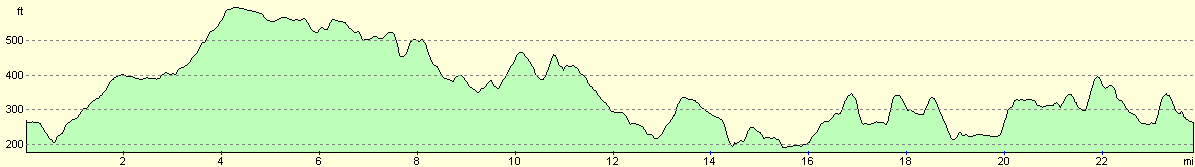
For more information on profiles, ascents and descents, see this page
Disclaimer
Please note that I take no responsibility for anything that may happen when following these directions. If you intend to follow this route, then please use the relevant maps and check the route out before you go out. As always when walking, use common sense and you should be fine.
If you find any information on any of these routes that is inaccurate, or you wish to add anything, then please email me.
All images on this site are © of the author. Any reproduction, retransmissions, or republication of all or part of any document found on this site is expressly prohibited, unless the author has explicitly granted its prior written consent to so reproduce, retransmit, or republish the material. All other rights reserved.
Although this site includes links providing convenient direct access to other Internet sites, I do not endorse, approve, certify or make warranties or representations as to the accuracy of the information on these sites.
And finally, enjoy your walking!
Nearby walks
| # | Title | Walk length (miles) |
|---|---|---|
| 709 | South Downs Way: Winchester to Wether Down | 20.4 |
| 787 | Romsey to Eastleigh via Winchester | 21.1 |
| 797 | A walk from Wickham to Old Winchester Hill | 23.1 |
|
|

|