Walk #197: Oykel Bridge to Inchnadamph
 |
 |
|
General Data
| Date Walked | 02/05/2002 |
| County | Highlands |
| Start Location | Oykel Bridge |
| End Location | Inchnadamph |
| Start time | 09.30 |
| End time | 16.55 |
| Distance | 18.2 miles |
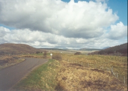
| Description | This is a long road walk, but the pain of the feet is offset with the wonders of the scenery. Along the first stretch of the walk the twin peaks of Suliven grow slowly as you approach them - a magnificent sight. |
| Pack | Full pack with five days food. |
| Condition | I am okay after this walk, and indeed with a little extra rest I could have walked on for a few extra miles. My feet did not ache as much as they have recently, and the chaffing, although it felt bad at times, did not prove itself to be a problem. I think that I may have a blister emerging on my left foot and my right knee was giving me gip early on. But aside from these minor niggles everything is fine, which is good after thirteen days out on the road. |
| Weather | The weather today was better than it has been of late, with some long periods of sunshine. There were several showers, however, and one of them at Ledmore was strong enough or me to put my coat on. The sun dried me out after each shower, so the rain was no real hardship. The wind was strong at times, and on the long walk to Ledmore Junction it was a headwind, which slightly hindered progress. |
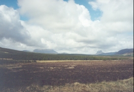
| OS map | Landranger number 16 (Lairg & Loch Shin, Loch Naver) and Landranger number 15 (Loch Assynt, Lochinver & Kylesku) |
 |
 |
|
Map of the walk
Maps courtesy of Google Maps. Route for indicative purposes only, and may have been plotted after the walk. Please let me have comments on what you think of this new format. For a detailed table of timings for this walk, please see the table file.
Notes
I told myself at the beginning of this walk that I would give myself regular rests of ten minutes every hour, so that me feet would have a chance to recover from the pounding that they were getting from the hard surface of the road. After the first hour, however, I felt fine so I continued on, and the same thing happened after the second and third hours had finished. At this stage I focussed all of my energy on getting to the Altnacealgach Motel on the shores of Loch Borralan, which I guessed would have a pub and therefore be an excellent place for a rest.
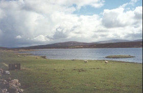
Shortly before I got to the Inn I passed a field at the southern end of Loch Borralan which was full of newborn lambs and heavily pregnant Ewes. One of the ewes was licking a brilliant white lamb, which I guessed had just been born. And in front a ewe was lying on her side, a most unnatural position for a sheep and one that initially made me think that she was dead. A few frantic kicks of the legs disproved this, and it then became obvious that she was in labour. When I got to the Inn I asked the landlord if the farmer was about, he replied that the farmer was regularly driving along the road between the fields where the pregnant ewes were and, sure enough a few minutes later he drove past.
I spent an hour in the Inn, during which time I had a pint and a half of beer and a steak and ale pie. I chatted to the landlord about various things, and on a notice board I found an advertisement for an independent hostel in Inchnadamph. Since this would almost certainly be cheaper than the hotel I phoned them up, and booked myself a private room for sixteen pounds. The Inn had a couple of 1:50,000 Ordnance Survey maps on the wall, so for the first time I could see my entire route to Cape wrath in one go, which was a lovely sight as it showed me how close I was to finishing.
Ledmore Junction is the place where the A835 road from Ullapool and the A837 road from Lairg meet. At this point the road got slightly busier (although only in relative terms) and it also became two carriageway which consequently made it safer. The initial part of the walk had been along the A837, and for the vast majority of the time it was a single-track road which meant that every few hundred yards there were passing places. One thing that surprised me about this road was, for such a quiet road, the proportion of coaches and foreign cars that came long it. I reckon that one in every three cars was foreign (judging from the numberplates), which is a high proportion for the UK.
At Ledmore Junction I came across my first sign showing John O'Groats on it. This was a quite emotional moment, as although it showed that I still had over 150 miles to go (more actually, as the road goes a shorter route than mine) the end is in sight. I took a photograph of the sign and of another on the other side of the junction and started smiling, which must have upset the rain gods as the heaviest shower of the day immediately started.
Tomorrow I have a relatively short walk to do to get to Kylesku. There are several routes that I could follow, the most boring being the walk along the road and the most adventurous being the route mentioned in the book "North to the Cape". A lady at the hostel told me that someone had attempted to do the latter route a few days earlier, but had failed due to the conditions underfoot and the streams which were impassable. For this reason if the weather is nice I shall take a middle ground and take a path that crosses the western flank of Glas Bheinn at a higher level than that of the road.
For once on this trip these notes were written the next morning instead of the night of the walk. I was so tired last night that after a half-hour soak in the bath I went to bed to read the next book of the 'Lord of the Rings' trilogy and went to sleep before nine. I do not really understand quite why I was so tired, but a long nights sleep has done me good.
Directions
This walk starts off at the Oykel Bridge Hotel, which is halfway between Inchnadamph and Lairg on the A837 road.
Turn right out of the hotel and join the A837 road, which is just a single carriageway with passing places. Follow it as it heads westwards, initially following the southern bank of the River Oykel. After the farm and river at Lubcroy is met the road starts to climb slowly northwestwards up the eastern flank of Mullach Chonachair before reaching Loch Craggie.
The road then continues north-westwards, crossing the Allt Eileag, rising slightly again and then descending to meet the northern shores of Loch Borralan, halfway along which is a Motel at which refreshments can be purchased. The road then continues for another mile and a half to Ledmore Junction, where the A835 road comes in from the west.
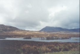
At Ledmore Junction the A835 road is followed northwards; this road has two carriageways and the going is good. The road slowly climbs to a summit at 162 metres before starting the long descent north beside the River Loanan past Stronchrubie and into Inchnadamph. Cross over the bridge that carries the road over the River Traligill and the hostel is up a driveway to the right.
Distances
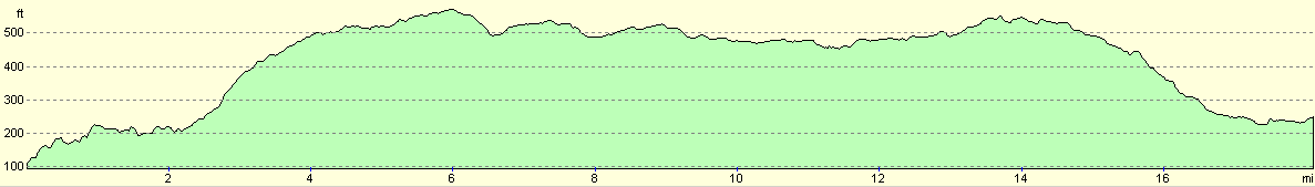
| From | To | Distance (m) | Ascent (ft) | Descent (ft) |
|---|---|---|---|---|
| Oykel Bridge | Allt Eileag | 6.6 | 669 | 289 |
| Allt Eileag | Ledmore Junction | 5.3 | 230 | 243 |
| Ledmore Junction | Allt nan Uamh | 3.6 | 157 | 184 |
| Allt nan Uamh | Inchnadamph | 2.7 | 66 | 269 |
This makes a total distance of 18.2 miles, with 1122 feet of ascent and 985 feet of descent.
For more information on profiles, ascents and descents, see this page
Accommodation
I stayed at the Independent Youth Hostel in Inchnadamph, which is also home to the Assynt Field Centre. A room cost me sixteen pounds for the night, but a shared room can be considerably less. The Hostel has a little shop where essentials such as beer and wine can be purchased.
The Inchnadamph Hotel is on the other side of the river from the hotel (indeed I could see it from my window) but is more expensive.
If nineteen miles to far to walk in one go, then the Altnacealgach Motel has a bunkhouse and also does B&B. This would make a very convenient place to stop if you were to split the walk over two days. The inn is open all year round, and can be contacted on (01854) 666260.
Disclaimer
Please note that I take no responsibility for anything that may happen when following these directions. If you intend to follow this route, then please use the relevant maps and check the route out before you go out. As always when walking, use common sense and you should be fine.
If you find any information on any of these routes that is inaccurate, or you wish to add anything, then please email me.
All images on this site are © of the author. Any reproduction, retransmissions, or republication of all or part of any document found on this site is expressly prohibited, unless the author has explicitly granted its prior written consent to so reproduce, retransmit, or republish the material. All other rights reserved.
Although this site includes links providing convenient direct access to other Internet sites, I do not endorse, approve, certify or make warranties or representations as to the accuracy of the information on these sites.
And finally, enjoy your walking!
This walk was mentioned in the following routes:
| My sectional Land's End to John O'Groats walk |
Nearby walks
| # | Title | Walk length (miles) |
|---|---|---|
| 196 | Croick Church to Oykel Bridge | 10.7 |
| 198 | Inchnadamph to Kylesku | 10.2 |
|
|

|