Walk #198: Inchnadamph to Kylesku
 |
 |
|
General Data
| Date Walked | 03/05/2002 |
| County | Highlands |
| Start Location | Inchnadamph |
| End Location | Unapool |
| Start time | 10.00 |
| End time | 15.30 |
| Distance | 10.2 miles |
| Description | This was a relatively short road walk, with some lovely views being available over the mountains to all sides. There is a long but slight climb which is followed by a slightly steeper descent. |
| Pack | Full pack with five days food. |
| Condition | I feel fine after this, the shortest walk of the trip so far. The biggest problem was with the blister which started developing yesterday on my right foot; this ached at times today despite having a Compeed on it. My right knee also hurt on the ascents, but this is becoming so usual that it is hardly worth mentioning. |
| Weather | The day dawned bright and sunny with a little cloud, but as soon as I started a heavy shower came over. Since it looked brighter on all sides I did not bother to stop to put my coat on and I let my fleece cope with it. There was no other rain of any significance for the rest of the walk. On the climb it was quite cold, and I could see my breath for the first time on this walk, but when the sun came out it soon warmed up. There was a nice little breeze which cooled me down as well, which was helpful. |
| OS map | Landranger number 15 (Loch Assynt, Lochinver & Kylesku) |
 |
 |
|
Map of the walk
Maps courtesy of Google Maps. Route for indicative purposes only, and may have been plotted after the walk. Please let me have comments on what you think of this new format. For a detailed table of timings for this walk, please see the table file.
Notes
This was a nice walk with lots of enjoyable scenery to be seen around the route. Although it is a road walk, there are far worse road walks that can be done. Some of the views are lovely, and the roads were agreeably quiet.
I have talked to several local people about the route between Kylesku and Inchnadamph that is recommended in the book "North to the Cape". This route goes via the top of the Eas a Chual Aluinn waterfall, which is Britain's highest waterfall. everyone that I spoke to said that the route was very difficult and that many people had got into trouble attempting it, particularly if the weather suddenly becomes bad. For this reason I chose to do a road walk instead of going via the rougher route.
On the descent down the hill I started to see three animals in front of me - one was black and he others white, and I thought that hey might be dogs. They were walking down the road and so it took me some time to catch up with them. Two of them were two sheep, with a very newborn lamb between them. As I approached one of the sheep drew away, leaving the lamb with one sheep, obviously it's mother. As they ran along and across the road I cold see that the lamb was limping - it was very hesitant to put it's left front leg on the ground. When I stopped at the shop a while later I reported this and they said that they would tell the owner when he next drove past. I could not help but feel sorry for that lamb, but I feel that my pity will not help it in this cruel world.
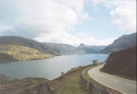
There was a real 'wow!' moment in this walk. The scenery during the climb had been impressive, with Quinag to the left and Glas Bheinn to the right. But when I started the descent down the big zig-zags just past the Loch na Gainmhich a panoramic vista opened up in front of me as I passed the shoulder of druim na h-Uhamha Moire - the northern flank of Quinag, Sa'il Gharbh, was to my left and whole range of hills were visible to the north. The whole view really took my breath away, and I paused for a minute so that I could take it all in.
During the ascent and descent it was obvious that the traces of an old single-track road was visible on the right. This was very narrow and much less straight than the new road, which was much wider. Even though the road is quiet, I am amazed that motorised traffic could use such a stretch of road over such terrain. Apparently the road was upgraded in sections to coincide with the opening of the Kylesku Bridge in 1984, and traffic volumes are now much larger than they were - which is not surprising considering the old state of the transport infrastructure. Steep, winding single-track roads and a car ferry that can only take two cars at a time is not conducive to lots of traffic!
I had not had a rest for the entire walk so far, so when I got to the old school a Unapool (whichis now a shop and cafe) I was in need of a rest. I went in and had a cup of coffee, a bowl of lovely mushroom soup and a piece of chocolate sponge cake. This went down nicely whilst I chatted to the lovely lady who runs the shop.
After this I left the shop and walked up and down hill to the pub at Kylesku, beside the slipway for the ferry which use to shuttle cars across the Loch until the bridge was built in 1984. Unfortunately the hotel had no rooms, and neither did another B&B in the village. Fortunately another one did, but that was about half a mile back along my route near the old school! I therefore decided that the best thing to do was to have a couple of fortifying pints in the hotel before ascending the hill to the B&B. I really did not fancy camping out tonight. I have really not been willing to camp out on this trip if it could not possibly be avoided for reasons that I cannot really explain - I have just not been in the mood for camping.
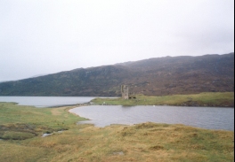
The climb back up the hill was well worth it however, as the B&B is very nice, with perhaps the best views of anywhere I have stayed, bar a hotel on the north coast of Cornwall. The room that I am staying in has lovely views over Loch Glencoul, and the view out of the sitting room window is the literal definition of picture-perfect. Indeed Kylesku itself is lovely, with picturesque surroundings and friendly people. The Post Office was had to find - it is a small wooden shed in someone's garden. Even the public toilets are larger!
In the evening I walked back down to the hotel for a meal. I had the nicest piece of haddock that it had been my pleasure to eat in a long time, and washed it down with a couple of pints of Tennant's Ember. Around the bar in the hotel are pictures of the old ferries that used to play between Kylesku and Kylestrome and pictures of the building of the bridge - naturally I found the latter of more interest. They reminded me of how easy it is to forget that such structures are actually hollow - one of the pictures is of the main span being lifted into position off a barge, and you get a very good view of it's cross-section.
Directions
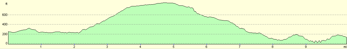
This walk starts off on the northern side of the bridge over the River Traligill in Inchnadamph on the A837. Head north along the A837 and follow it as it climbs and descends to meet the eastern side if Loch Assynt. Pass the ruins of Colda House and then the remnants of Ardvreck Castle. About a kilometre further on a road junction is met at Skiag Bridge.
Turn right to head uphill to the north along the A894 road. The road winds around as it ascends, but the slope is such that I only had to stop once to catch my breath - it is steep but manageably so. Eventually the road becomes straighter as the gradient slackens until a summit is reached at about 261 metres, which means a climb of 190 metres from Skiag Bridge.
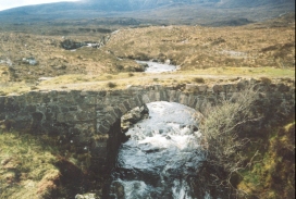
The road then descends past the Loch na Gainmhich. At the northern tip of the loch the road starts a steep and windy descent, but this is more than made up for my magnificent views to the north. The road becomes straighter and the descent less marked at Unapool bridge and shortly after this the junction with the B869 road is reached.
Continue along the A894 for about a mile until Unapool is reached. On the right near the bottom of a hill is a little shop that serves lovely home-made cake. A little further up the hill on the right is the road that leads to the B&B that I stayed in.
To continue into Kylesku continue to the top of the hill and follow the road as it swings around to the right and starts to descend. At the bottom of the hill a road leads off to the right; about a quarter of a mile away at the end of this road is the Kylesku Hotel.
Distances
| From | To | Distance (m) | Ascent (ft) | Descent (ft) |
|---|---|---|---|---|
| Inchnadamph | Skiag Bridge | 2.1 | 253 | 276 |
| Skiag Bridge | Loch na Gainmhich | 3.5 | 705 | 233 |
| Loch na Gainmhich | Kylesku Hotel | 4.6 | 531 | 1096 |
This makes a total distance of 10.2 miles, with 1489 feet of ascent and 1605 feet of descent.
For more information on profiles, ascents and descents, see this page
Accommodation
I stayed at 'The Ridge' B&B, Unapool Croft Road, Kylesku, Sutherland, IV27 4HW. Telephone 01971 502226. This was a lovely little B&B, with some breathtaking views over the mountains and the lochs. The landlord is very friendly and I had a nice long chat with him.
For other accomodation nearer town, there is the Kylesku Hotel, a B&B near to it, and the Kylesku Lodges and Backpackers. The latter is open from March to October, and has 12 beds and costs from £10.00 per person. For more information on the lodges phone (01971) 502003.
Disclaimer
Please note that I take no responsibility for anything that may happen when following these directions. If you intend to follow this route, then please use the relevant maps and check the route out before you go out. As always when walking, use common sense and you should be fine.
If you find any information on any of these routes that is inaccurate, or you wish to add anything, then please email me.
All images on this site are © of the author. Any reproduction, retransmissions, or republication of all or part of any document found on this site is expressly prohibited, unless the author has explicitly granted its prior written consent to so reproduce, retransmit, or republish the material. All other rights reserved.
Although this site includes links providing convenient direct access to other Internet sites, I do not endorse, approve, certify or make warranties or representations as to the accuracy of the information on these sites.
And finally, enjoy your walking!
This walk was mentioned in the following routes:
| My sectional Land's End to John O'Groats walk |
Nearby walks
| # | Title | Walk length (miles) |
|---|---|---|
| 197 | Oykel Bridge to Inchnadamph | 18.2 |
| 199 | Kylesku to Scourie | 11.3 |
| 520 | Clachnessie to Duartbeg via Kylesku | 23.1 |
|
|

|