Walk #958: Suffolk Coast Path: Boyton Dock to Felixstowe Station
 |
 |
|
General Data
| Date Walked | 09/08/2012 |
| County | Suffolk |
| Start Location | Boyton Dock |
| End Location | Felixstowe Station |
| Start time | 06.57 |
| End time | 13.52 |
| Distance | 15.3 miles |
| Description | This is an easy and pleasant walk following the Suffolk Coast Path down the Ore, than along the coast to the ferry across the Deben. A pleasant wak along a promenade then leds to Felixstowe Pier. |
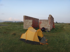
| Pack | Today I carried my Macpac Glissade rucksack containing my North Face Westwind tent, spare clothes, waterproofs, water, and enough food to last two days. In total it weighed about thirty-three pounds. |
| Condition | My feet are aching a great deal after this stroll, a result of having got my feet wet early-on in the walk. |
| Weather | Today started off bright and sunny, although cloud soon rolled in. This was welcome as it helped keep temperatures down. |
| OS map | Landranger number 169 (Ipswich & The Naze, Clacton-on-sea) |
 |
 |
|
Map of the walk
Maps courtesy of Google Maps. Route for indicative purposes only, and may have been plotted after the walk. Please let me have comments on what you think of this new format. For a detailed table of timings for this walk, please see the table file.
 |
 |
|
Notes
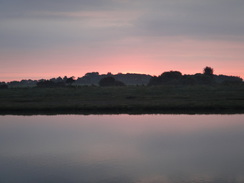
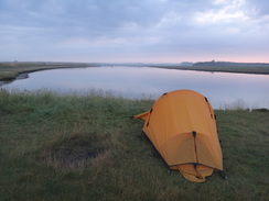
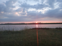
I unzipped my tent this morning to be greeted by gloriously reddening skies to the east. Regular flashes marked the site of Orford Ness lighthouse in the distance. No-one was about, but I was in no hurry to set off. The River Deben was about nine miles away, which I would have to cross by a ferry that only started operating at ten. For this reason there was little point in walking until nearer seven, so I lay on my mat and listened to the radio as the sun slowly rose.
Eventually boredom got the better of me and I slowly packed up my kit. My shoulders, which had been aching at the end of yesterday's near-marathon walk, felt fine under the load, but I had a big six-inch diameter swelling on my right hip from an insect bite that had rubbed against my trousers, belt and rucksack. Annoyed that I had left my antihistamine cream at home, I did the best I could to rearrange things and headed off.
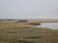
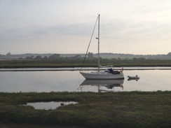
One of the yachts moored in the river had woken up, and friendly voiced carried easily across the river. There were a couple of strange concrete structures in fields to the right, away from the river. I assume that these were something to do with the defence of this stretch of coast, which had a large research establishment at Orford Ness and a radar research establishment at RAF Bawdsey in close proximity.
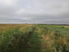
For some reason I was finding the grassy path at the top of the bank troublesome, and I kept on partially rolling over either ankle. This was due to rubbery legs, but either my legs or the path improved, for after a mile or so everything was fine. The same was not true for my right arm, which had swollen up considerably from multiple insect bites.
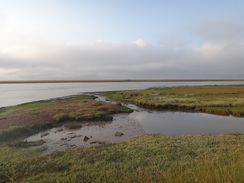
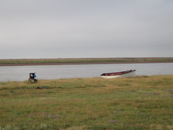
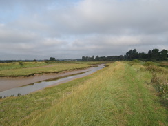
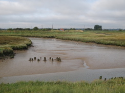
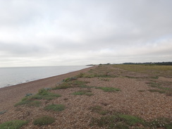
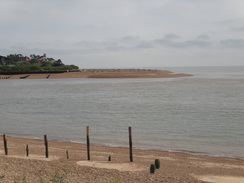
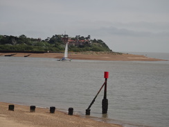
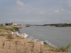
The trail turned a couple of corners to join the northern bank of the River Ore, where a canoeist was paddling furiously upriver. A thousand years ago open sea would have stretched out to my left, but longshore drift had cut off Orford's direct route to the sea and created the massive ten-mile long Shingle bank of Orford Ness.
The Ore would be my companion for the next few miles, but it did not take long for the walk along the flood bank to become boring despite some pleasant watery views. At one point the grass on the flood bank had not been cut, and the knee-high vegetation soon had my trousers sopping wet. This soon wicked down into my boots, meaning that my socks and feet were damp. After less than half a mile the going became easier once again. Sadly my damp feet were going to play havoc with me for the rest of the day.
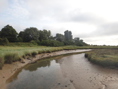
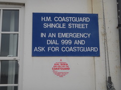
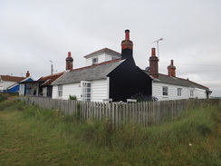
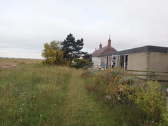
Eventually the flood bank and trail diverted inland to reach a road that crossed a little creek. The trail follows a floodbank slightly away from the river, but this was very overgrown and so I just followed the road instead. Soon I was back on the flood bank on the southern side of the creek, reaching the mouth of the River Ore beside two large shingle islands: whether they were remnants of a breech in the end of the shingle ridge or prepubescent extensions, I do not know. The flood bank turned to follow the coast as white buildings became visible ahead: the coastguard cottages at Shingle Street.
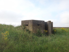
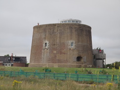
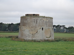
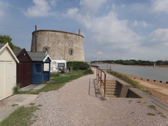
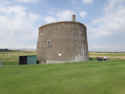
The weather had been terrible when I walked this part of the coast ten years ago as part of my coastal walk, and I had stopped my day's walk nearby due to the rain. Fortunately the weather Gods were looking more kindly upon me today, and if anything it was getting sunnier as the few clouds blew away. Progress over the shingle behind the houses was difficult, especially with my pack on, and it was a relief when the trail headed inland slightly to approach Martello Tower AA, a massive almost-circular brick structure that was built to defend the coast from Napoleonic attack. 103 of these forts were built along the Suffolk coast, along with their sisters in Sussex. Time and tide has destroyed most of them, but many remain. Tower AA, like most of the remaining towers, has been converted into accommodation.
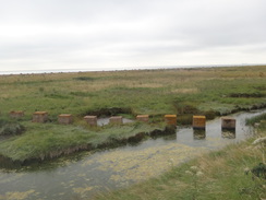
The trail passed the fort and then took a footpath that headed off, crossing a stream before joining a flood bank. This soon passed another Martello (tower Z), which remains unconverted. Another Martello was visible ahead; the map showed the trail leaving the flood bank and going over to the shingle, but either I missed the turning or erosion has converted it into marshy ground because I continued on along the bank in a fruitless attempt to find it. Soon the marshy ground on the left was replaced by a lake that took me up to the next Martello (tower Y), which looked spick and span - it had only just been converted into accommodation.
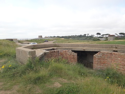
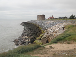
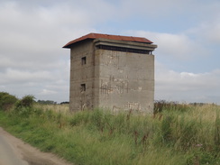
A handy flood bank split the lake into two and allowed me to join the shingle path and the trail. This was rather pointless, as all the effort of walking over the shingle was rewarded with me rejoining the original flood bank a short distance on. This became a path that passed a long line of rip-rap; large blocks of stone placed to help prevent coastal erosion. Another Martello lay ahead (tower W), but more prominent was a large concrete observation tower that was part of the World War Two air defences in the area. It was interesting to see the juxtaposition of defences built nearly 150 years apart. Martello W was now a home, but the spalled concrete on the 1940s observation tower revealing the rusted reinforcing bars. These warned of a more ominous fate for the newer structure.
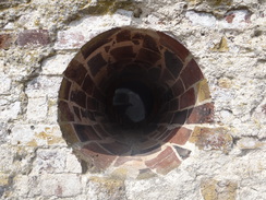
Walking on the shingle had played havoc with me damp feet, and so I sat down on a grassy bank overlooking the observation tower, with the disused gun platforms flanking me. I took my boots off and let the sun start to dry them off. My map showed the trail following the cliffs south. However a sign said that once again the coast path was closed due to erosion and a diversion has been made inland. I put my boots back on and walked past the observation post, which had a strange metal grate on the observation slit with writing in obverse and reverse.
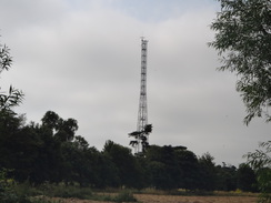
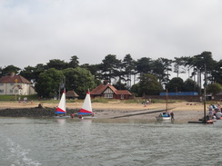
Sadly the diversion was along roads, initially into the village of Bawdsey itself before heading towards the River Deben. A tall mast marked the site of RAF Bawdsey, where British boffins developed the radar systems that helped us win the Battle of Britain. The site is now home to a museum that is occasionally open, and is on my list to visit. It was now well past ten and so the ferry across the Deben was due to be running; I took my time to ease my aching feet and was surprised to find a sandy beach before reaching the ferry landing at Bawdsey Quay.
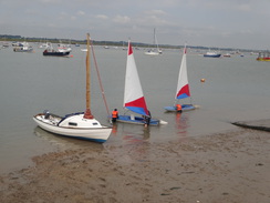
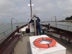
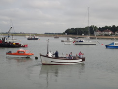
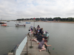
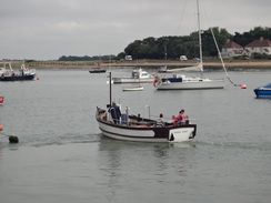
A string of people were crab-fishing from the landing, and I squeezed past with my rucksack to reach the ferry, which was waiting. The ferryman wordlessly took my money and I sat down ready for the trip across. I usually love ferry trips and this was no exception, even if the journey was all too soon over. On the other side I said goodbye and squeezed past yet more crab fishers to reach the road at Felixstowe Ferry.
Here I had two choices: one route strikes inland to miss Felixstowe and the docks, whilst a second follows the coast around. I decided to take the latter, and soon I was passing a pub. As I was in need of a rest I nipped over to the pub to find the door locked. I was about to turn away when it was unlocked: it opened at eleven and I had arrived just a couple of minutes early!
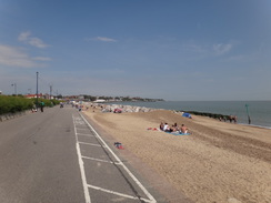
I sat outside as I supped a couple of pints, leaving my feet in the sun in an attempt to dry out my socks. A few people trickled into the pub, and I sat and watched as others walked along the flood bank. After an hour I decided it was time to set off once again. The flood bank took me past another converted Martello (tower U), and became a seawall at the river mouth. I passed Martello tower T which was marooned within a golf course and continued on along the promenade. The going should have been easy but it did not feel it, as my feet were now hurting rather than just aching.
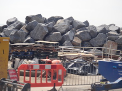
Eventually a sign showed that the trail headed up onto the cliffs, then followed roads past Cobbolds Point. It soon rejoined the promenade to the south of the point, where there were large works and massive piles of rip-rap boulders. Signs showed that these were going to be used to protect the point and that a promenade would be created to link the two separate stretches to the north and south - when this is completed it will be a welcome addition.
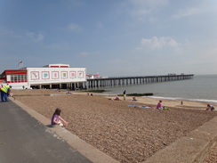
My eventual destination of Felixstowe railway station was a short distance away to the west, but I put my aching feet to the back of my mind and continued on towards the pier, which I was sad to see was blocked off, condemned as being in an unsafe condition in 2002. There are plans for the entire pier to be rebuilt, but this will only involve the buildings nearest to the sea. The remainder of the pier would be demolished, and this would be a sad end to what was once one of the longest piers in Britain at 800 metres in length.
I bought an ice cream and licked this as I headed along the promenade, although it was melting so fast that more seemed to end up on my clothes than in my mouth. The sun was really beating down on me by now and the heat was getting a little too much for me. About half a mile on the trail leaves the promenade and heads inland to pass the modern port; I followed the trail along a road for a short distance before heading off down a main road towards the railway station. I really wanted to walk further, but I was unsure of train times and had a long journey home. Besides, my feet were really hurting and I could only think of getting home.
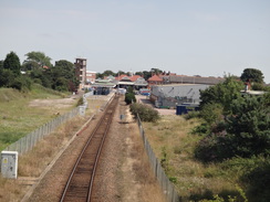
Felixstowe station is little more than a terminus halt, the rather grander old station and its canopies now being a shopping centre. I put my rucksack down and waited for the train, looking back on what had been a pleasant if strenuous three-day coastal backpack. The coast of Suffolk deserves more attention that it gets; it is truly a gem. If only they could make the coastal path more coastal in places...
 |
 |
|
Directions
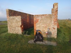
This walk starts off at the ruins of a brick building at Boyton Dock at TM392474. Climb up onto the floodbank and turn left to start following the bank southwards. The bank soon curves to the left to head southeastwards, and then again to take a more easterly course. Half a mile after the dock, a corner of the floodbank is reached near the confluence of the Butley and the Ore rivers. Here the bank turns to head southwards for a third of a mile to reach Flybury Point at TM396465.
At Flybury point the bank curves to the right to take a more west-southwesterly course. The directions are simple: stay on the floodbank as it heads alongside the River Ore on the left, going through any gates and crossing any stiles that you come across. After 1.25 miles at TM381453 the map shows the path heading off the bank to the right, to rejoin it half a mile later. This route seems fairly impassable currently (2012), so just continue along the flood bank which eventually runs alongside a track for a short period.
As the track curves to the right to head inland towards Hollesley, turn left through a pedestrian gate and continue along the floodbank with the river on the left. When a bend is reached at TM371439, the bank turns to the right to head inland with Barthorp's Creek on the left. This emerges out through a clapper gate onto a road.
Cross the road and take a footpath on the other side, which follows a flood bank southwards. This soon curves to the left and crosses a stream before ending at the same road; it may be easier to miss this short section of path off and instead to just follow the road. Cross this and then take a path that runs along the top of a floodbank on the southern side of Barthorp's Creek. This twists and turns for a third of a mile until it meets the mouth of the River Ore.
Here the bank turns right to head south-southwestwards for half a mile as a road approaches from the right. When the road is met, the bank curves to the left to reach a track. Leave the bank and turn right to start heading south across grass and shingle towards the Coastguard Cottages at Shingle Street at TM369429.
Walk past the gable end of the cottages and then turn right, to continue with the cottages to the right and the beach and sea to the left. Patches of grass covers the shingle, but the going can he quite hard as the path passes the cottages. After the last cottage, turn slightly to the right across some grass towards a Martello tower ahead. Meet the concrete road that runs in front of the tower, and then turn left along the road.
Once past the tower, turn right along a path that runs between fences, with the tower on the right and a cottage on the left. The path curves to the left behind the cottage, and after a short distance turn right to follow the path as it emerges out onto the marshland. Immediately turn half-right to follow a distinct path westwards. The path soon forks; take the left-hand branch and follow it until it meets a track running along the base of a flood bank ahead. Turn left along this track, which soon climbs up onto the top of the bank at TM363423.
At the top leave the track by turning left to start following the flood bank south-southwestwards for 0.8 miles; soon a track joins at the base of the bank on the right. The bank and track heads past anther Martello tower in a field on the right to reach a third tower at TM358410. Here the 1:25,000 and 1:50,000 maps disagree about the route; one has the trail heading to the left along a short flood bank to reach the shingle beach, whilst the other continues along the flood bank. The latter is by far the easier route, and as the bank joins the beach a path begins; this leads on to reach the remains of old gun emplacements beside a car park at TM357400, with a fourth Martello Tower ahead.
Here the route differs again; the old route followed the coast southwestwards, but the initial part of this route is closed. Descend off the bank and head through the car park, before heading inland westwards along the access road towards Bawdsey. When a road junction is reached after half a mile, turn left down another road that heads southwestwards for a couple of hundred yards until it ends at a T-junction with Ferry Road in Bawdsey at TM348398.
Again there are several different routes that can be taken: the easiest is to turn left and follow Ferry Road in a rough southerly direction; after 0.8 miles it curves to the right slightly to head west-southwestwards. After another three-quarters of a mile the road approaches the eastern bank of the River Deben, before curving to the left to reach Bawdsey Quay at TM331378.
Another route is available, but this may be inaccessible at high tides. Follow Ferry Lane south as it passes Bawdsey Hall; after nearly a third of a mile turn left through a pedestrian gate beside a double field-gate. This path heads east-southeastwards for a quarter of a mile until it reaches the sea at the top of low cliffs. Descend down onto the shingle beach and start following this southwestwards, passing Bawdsey Manor at the top of the cliff. After 1.5 miles the mouth of the Rive Deben is reached; here the path curves to the right to head north for a fifth of a mile until the quay is reached at TM331378.
A passenger ferry runs between Bawdsey Quay and Felixstowe Ferry on the southern bank of the river at certain times of the year; always check whether the ferry is running before attempting this section of the walk. Once on the southern side of the river follow the road south for a short distance until some steps lead up to the left onto the top of a flood bank. Follow this flood bank as it heads southwards, it soon squeezes past a Martello Tower before curving slightly to the right to take a more southwesterly course.
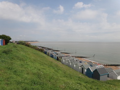
The path passes a golf course on the right, and then another Martello tower that is now used as a golf course storeroom. Continue along the path southwest from the golf-course tower; it soon joins a promenade and runs past a series of beach huts. Just before the promenade ends after a mile at TM318353, turn right up some steps that lead up onto the clifftop. Continue along a path that passes a car park on the left before it ends at Golf Road. Turn left and follow this road as it curves to the right, and when the road ends turn left down Maybush Lane. This curves to the right and after a quarter of a mile drops down to reach a promenade at TM314348. At the time of writing (2012) a new promenade is being constructed past Cobbolds Point, which will mean that the diversion along roads described above will no longer be needed.
Follow the promenade as it heads west-southwestwards, and after nearly a mile it reaches Felixstowe Pier at TM300341. Pass the pier and continue along the promenade for another half a mile until the road running off to the right ends at TM295333. Turn right to leave the promenade and head straight on along Beach Station Road. When this ends at a T-junction, turn right to follow the A154 Langer Road north-northeastwards. This reaches a roundabout after 0.4 miles.
Go around the roundabout, crossing Undercliff Road West on the right before turning right along Garisson Lane. This curves to the right to take a more northeasterly course, and then to the left. After three-quarters of a mile the road climbs up to cross a bridge over a railway line, and at traffic lights on the other side turn right down High Road West. Follow this eastwards for a few hundred yards and then turn right down Railway Approach. Felixstowe railway station is a short distance away on the right at TM302351.
 |
 |
|
Distances
| From | To | Distance (m) | Ascent (ft) | Descent (ft) |
|---|---|---|---|---|
| Boyton Dock | Felixstowe Ferry | 9.6 | 51 | 51 |
| Felixstowe Ferry | Felixstowe station | 5.7 | 246 | 174 |
This makes a total distance of 15.3 miles, with 297 feet of ascent and 225 feet of descent.
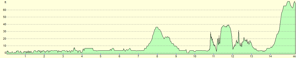
For more information on profiles, ascents and descents, see this page
 |
 |
|
 |
 |
|
 |
 |
|
 |
 |
|
 |
 |
|
 |
 |
|
 |
 |
|
 |
 |
|
 |
 |
|
 |
 |
|
 |
 |
|
 |
 |
|
 |
 |
|
 |
 |
|
 |
 |
|
 |
 |
|
 |
Disclaimer
Please note that I take no responsibility for anything that may happen when following these directions. If you intend to follow this route, then please use the relevant maps and check the route out before you go out. As always when walking, use common sense and you should be fine.
If you find any information on any of these routes that is inaccurate, or you wish to add anything, then please email me.
All images on this site are © of the author. Any reproduction, retransmissions, or republication of all or part of any document found on this site is expressly prohibited, unless the author has explicitly granted its prior written consent to so reproduce, retransmit, or republish the material. All other rights reserved.
Although this site includes links providing convenient direct access to other Internet sites, I do not endorse, approve, certify or make warranties or representations as to the accuracy of the information on these sites.
And finally, enjoy your walking!
Nearby walks
| # | Title | Walk length (miles) |
|---|---|---|
| 132 | Wickham Market Station to Darsham Station | 12.7 |
| 261 | Aldeburgh to Chillesford via Orford | 17.8 |
| 262 | Chillesford to Bawdsley | 10.8 |
|
|

|