Walk #262: Chillesford to Bawdsley
 |
 |
|
General Data
| Date Walked | 10/11/2002 |
| County | Suffolk |
| Start Location | Chillesford |
| End Location | Bawdsey |
| Start time | 07.45 |
| End time | 11.28 |
| Distance | 10.8 miles |
| Description | This was a short walk which should have been very enjoyable, but was made not so by the awful weather. |
| Pack | Today I carried my 30-litre Karrimor HotRock rucksack, which was filled with my packed lunch, waterproof leggings, water bottle and a couple of spare shirts, together with the usual assortment of odds and ends. |
| Condition | I feel absolutely fine after this walk, and have no real problems to report. This is to be expected after such a short walk, but it is welcome nonetheless. Hopefully the short day will allow me a little time to relax so that I can do a long day tomorrow. |
| Weather | Today was a very bleak day. As I lay in bed this morning I could hear the rain drum on the roof of the van a couple of feet above my head and the wind was blowing around the van. As soon as I started the walk the weather improved slightly, with light wind and showers accompanying me. Unfortunately this did not stay the case for long, and as the morning went on it started to deteriorate with the winds getting stronger and the rain showers increasingly more frequent and heavier. When I got to Bawdsey and met Sam for lunch the rain was very heavy and I was doing an excellent impression of a drenched rat, so I decided to call it a day. I could easily have coped with the rain (there has been worse previously on this trip), but when coupled with the wind it made the whole scenario thoroughly depressing. |
| OS map | Landranger number 156 (Saxmundham, Aldeburgh & Southwold) and Landranger number 169 (Ipswich & The Naze, Clacton-on-sea) |
 |
 |
|
Map of the walk
Maps courtesy of Google Maps. Route for indicative purposes only, and may have been plotted after the walk. Please let me have comments on what you think of this new format. For a detailed table of timings for this walk, please see the table file.
Notes
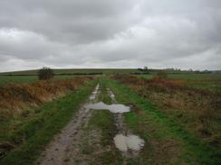
Aside from the rain one of the worst features of this walk was the thick, cloying mud which was a feature of much of the walk around the sea bank from Flybury Point to Shingle Street. Long stretches of this path were okay, but then a section which had been churned up by animal hooves would be reached and I would be slipping and sliding around. The ground really is quite badly saturated,
There is something about being out in heavy rain with a strong headwind, which makes you seek shelter. And when that shelter involves your home with a lovely lady waiting for you, it becomes very hard to drag yourself out into the stormy weather once more. Such was the case today, for when I had met Sam at Bawdsey I decided to sit in the van so that I could eat lunch in the dry. We waited there for an hour and a half but the rain and wind still had not stopped, so I decide to take a look outside to see if I wanted to walk further. I climbed on top of the sea bank and the wind instantly made me feel cold, so I decided that stopping the day's walk short would be the best idea.
I feel so relaxed this afternoon compared to how I normally feel after a walk, even though I am annoyed I have done a short distance. I can only conclude that doing a short day every so often causes me to relax more and gives me a chance to rest, which cannot be a bad thing.
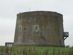
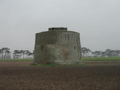
Today was yet another day when the rain spoilt some of the photographs that I had taken. Fortunately the situation was not as bad as it had been earlier in the week and I mainly lost only some photographs of the Martello Towers. It was raining heavily when I took them, and so I decided to take multiple photographs that meant that some were okay. I am going to have to try to find a way over this problem - if it raining very heavily I may resort to using my film camera for some shots, but that means that the photos will not appear on the website until after the trip.
If I had not had such a short day today it should have been possible for me to get to Felixstowe Ferry tomorrow and Ipswich on Tuesday. Because I did not do the full distance I am behind that schedule, and so tomorrow Sam has booked us into a campsite at Waldringfield which I shall be able to walk to. This will leave me somewhere north of Felixstowe on Tuesday and have me going through Ipswich on Wednesday. This is all of course if I have no further changes to my schedule.
Directions
This walk starts off from the Froize Inn in Chillesford. From the inn car park turn left and follow the B1084 road westwards through the village. Take the first road to the left, Mill Lane, and follow it past a mill on the right. On a right-hand bend turn left down a good, sandy track. The track passes Low Farm and skirts Carmen's Wood before ending at a T-junction with a surfaced road.
Turn left down this road and follow it northeastwards for a coupe of hundred yards to Butley Low Corner. At this corner turn right down another sandy track that heads southeastwards, skirting to the right of two areas of woodland before entering an area of marshland. The track continues on before rising up the prominent Burrow Hill along a footpath. From the top of Burrow Hill descend down until the path ends at a T-junction with a track. At this junction turn left and follow the track until it ends at a sea bank beside the landing stage for the Butley Ferry.
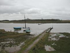
At the sea bank turn right and heads south along the western bank of the river until Flybury Point is reached after about a mile. At this point the path turns to head in a more southwesterly direction, again with the River Ore to the left and Orford Ness visible on the other side of the river.
After a few miles the sea bank turns inland for a few hundred metres alongside an inlet into the river. Eventually a bridge is reached which carries a surfaced road; cross this bridge and immediately on the other side turn left and follow a footpath that leads up the other side of the inlet. At the end of the inlet the bank turns to the right and enters the long village of Shingle Street. Continue on through Shingle Street between the houses and the sea until the Martello Tower in the village is reached. Here take a path that heads inland past the tower until a sea bank is reached. Turn left and follow the top of this sea bank for a couple of miles until the car park at East Lane, Bawdsey, is reached, passing another two Martello Towers on the way. Instead of walking along the top of the bank you can walk along a track that runs along the inland side of the base of the bank. As another alternative you could walk along the shingle beach from Shingle Street southwards, but this means walking on a very uneven surface.
Distances
| From | To | Distance (m) | Ascent (ft) | Descent (ft) |
|---|---|---|---|---|
| Chillesford | Butley Ferry | 3.4 | 105 | 131 |
| Butley Ferry | Bawdsey | 7.4 | 72 | 69 |
This makes a total distance of 10.8 miles, with 177 feet of ascent and 200 feet of descent.
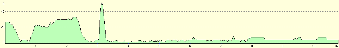
For more information on profiles, ascents and descents, see this page
Accommodation
We stayed at Bailiff's Cottage, which is near Shottisham and midway along the road that runs from Shottisham to Hollesley. This is a simple site with no toilet or shower but it does have an electrical hook-up. They can be contacted on 01394 411275, and it cost us five pounds fifty pence for the night.
Disclaimer
Please note that I take no responsibility for anything that may happen when following these directions. If you intend to follow this route, then please use the relevant maps and check the route out before you go out. As always when walking, use common sense and you should be fine.
If you find any information on any of these routes that is inaccurate, or you wish to add anything, then please email me.
All images on this site are © of the author. Any reproduction, retransmissions, or republication of all or part of any document found on this site is expressly prohibited, unless the author has explicitly granted its prior written consent to so reproduce, retransmit, or republish the material. All other rights reserved.
Although this site includes links providing convenient direct access to other Internet sites, I do not endorse, approve, certify or make warranties or representations as to the accuracy of the information on these sites.
And finally, enjoy your walking!
This walk was mentioned in the following routes:
| My walk around the coastline of Britain |
Nearby walks
| # | Title | Walk length (miles) |
|---|---|---|
| 131 | Ipswich to Wickham Market Station | 16.7 |
| 132 | Wickham Market Station to Darsham Station | 12.7 |
| 260 | Southwold to Aldeburgh | 18.0 |
|
|

|