Walk #260: Southwold to Aldeburgh
 |
 |
|
General Data
| Date Walked | 08/11/2002 |
| County | Suffolk |
| Start Location | Southwold Pier |
| End Location | South Warren in Aldeburgh |
| Start time | 07.16 |
| End time | 14.28 |
| Distance | 18.0 miles |
| Description | This was a nice walk following the coast southwards from Southwold along the Suffolk Coast, passing the two nuclear reactors at Sizewell on the way. |
| Pack | Today I carried my 30-litre Karrimor HotRock rucksack, which was filled with my packed lunch, waterproof leggings, water bottle and a couple of spare shirts, together with the usual assortment of odds and ends. |
| Condition | I feel okay but a little fatigued after this walk. My left ankle was again aching at times, particularly on uneven ground, and I will have to keep an eye on this to see it does not get worse. Aside from this things were more or less fine, with no real problems to report. |
| Weather | The weather started off reasonably today, with a thick layer of cloud overhead and a few sunny periods. By about eleven a light rain started and the wind picked up, and this rain became heavier and heavier as the afternoon progressed. The wind also picked up, and as it was a headwind along the beach this made the walk harder than it otherwise should have been. |
| OS map | Landranger number 156 (Saxmundham, Aldeburgh & Southwold) |
 |
 |
|
 |
 |
|
Map of the walk
Maps courtesy of Google Maps. Route for indicative purposes only, and may have been plotted after the walk. Please let me have comments on what you think of this new format. For a detailed table of timings for this walk, please see the table file.
Notes
After the lovely weather of yesterday followed another wet and windy day in which walking was far from a pleasure. Unlike Wednesday the rain did not start until halfway through the walk, so I at least had a dry start to the walk so I am not as depressed as I had been on Wednesday evening.
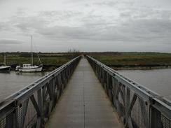
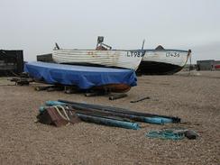
The first challenge of the day was to cross the River Blyth. The first bridge along the river is about a mile upstream, so I walked along the beach from the pier in Southwold to the lifeboat station and then headed along the riverbank upstream. The northern side of the river is filled with boats and the banks are dotted with boatyards, with many boats out of the water and being worked on. I found particularly fascinating the machines used to lift and haul the boats out of the water; they are strange and ungainly contraptions that seem to be at home neither in the water nor on land. The first bridge for pedestrians is soon reached, and is built on the site of the old bridge over the river used by the Southwold Light Railway, which shut in 1929.
I found the walk along the beach from Walberswick to Dunwich to be quite hard, as it was along a shingle beach. At first I dropped down the beach to a little line of hard sand lying on the shingle, but halfway down the beach this stopped and I had to resort to walking on the shingle. Fortunately nearer Dunwich a firm path appeared on the marshes on the right, so I dropped down onto this for the last mile into Dunwich.
Dunwich is a nice little place - the ruins of the thirteenth century Franciscan Friary are small but nice, and every road in the village seems to have a Friary connection - there is a GreyFriars Wood, and houses called Whitefriars, SouthFriars, etc. I stopped off at the cafe and the shop in Dunwich, hoping to get something to eat, but unfortunately they were not starting to cook food until 10.30. I bought myself a couple of snacks instead and had a quick chat with the person serving about what I was doing. Dunwich used to be a busy town, but slowly over the years the sea has taken it. In 1326 a storm blocked the harbour mouth and destroyed three churches and over time the harbour defences, the harbour itself, the sea destroyed the cliffs and then the town. In 1677 the sea reached the market place and in 1919 the tower of All Saints' church vanished. Parts of the graveyard of the church used to be visible buried in the sand dunes until recently, a sombre reminder of the power of the sea.
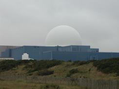
The two nuclear reactors at Sizewell - the A and the B reactors - dominate the local area. The A reactor was built in 1958, and the B reactor was finished after much controversy in 1995. I must admit that I find the B power station to be attractive in a strange sort of way - the blue of the buildings contrasts well with the white of the reactor dome. The A power station, however, is a different matter, with a grey, bland concrete building that is typical of the worst of sixties architecture.
As I was approaching Sizewell Sam called me up on my mobile and asked me if I wanted some soup. As the rain was stating to get heavier I agreed, and I met her at the car park in Sizewell. She made me a lovely hot bowl of chicken soup that hardly touched my sides as I gulped it down. Yet again Sam has proved indispensable to me, and it is little things like this that are making this walk easier.
Aldeburgh is a pretty little town, but as it was raining hard when I got there I did not wait around to look at it - most seaside towns appear grey and unappealing in heavy rain. Sam picked me up a couple of miles further on along the A1094 road, and when we got back to the caravan site near Sizewell I did a radio interview with BBC Radio Cambridgeshire. It looks as though next Saturday morning I will be doing one with BBC Radio Essex - I should be somewhere near Harwich at that time. Next Saturday is also the first driver change of the trip - Sam is going scuba diving to the Red Sea for a week, so I am having a friend, Mike, take over for a few days before another one takes over.
On the way back from the end of the walk to the campsite in Sizewell we had to drive through the little village of Leiston. Just south of the village we came across a tractor in the lane which was going from one side to the other very, very slowly. The drivers actions seemed to be those of a drunkard or a madman, but after a few seconds we realised that he was actually using the tractor to herd pigs down the road! This was a very curious sight, and I am absolutely flabbergasted how using a tractors to herd pigs should be easier than doing it a more traditional way. After a few minutes he got the pigs into his farm and we could continue on our way.
I now have a few days in which I will be spending the majority of my time inland, heading up river estuaries in order to cross them. Early on in planning this walk I made the decision that I was not going to walk along Orford Ness (none of the other coastal walkers I have heard about did it either), but even without this it will take me four days to reach Ipswich. Tomorrow I will have to cross the River Alde, and it is then simply a job of getting down to Orford along the eastern bank of the river.
Directions
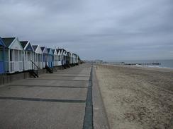
This walk starts by the pier in Southwold. Turn right and follow the beach southwards, passing the attractive multi-coloured beach huts which the town is famous for. When you reach the Alfred Corry Museum by the lifeboat station turn right and follow the north bank of the river through a series of boatyards until after a mile you reach a footbridge over the river.
Cross the river and immediately turn left to walk down the southern bank of the river. The path approaches Walberswick before turning slightly to the right away from the river bank, crossing a road and going through a car park before reaching the beach at the mouth of the river.
Turn right and follow the shingle beach southwards for about three miles to Dunwich. The shingle can be hard to walk on, but at times there is a path immediately on the inland side of the beach between the beach and the marshes that may offer easier going. When the car park and cafe in Dunwich are reached. At the cafe join a surfaced road that heads inland before turning left down a footpath that enters a wooded area. Follow this path as it skirts the cliff edge before passing the ruins of the Friary and ending at an unsurfaced track. Follow this track inland until it ends at a surfaced road. Continue on down this road for about a hundred yards and then turn left down a driveway, following another public footpath.
Follow the path as it heads south along the driveway, passing through a lovely wooded area. The houses end and the track becomes more overgrown before it turns to the right and then the left and ends at a surfaced road. Turn left down this road and follow it past the caravan site at Cliff House and a car park on the right until it reaches the National Trust visitors centre at Dunwich Heath.
Continue on towards the car park of the visitors centre and when the surfaced road turns to the left continue straight on down a track that leads down to the beach. When the beach is reached continue along it southwards towards the dome of the Sizewell B reactor. You can wither walk along the shingle beach or along a path which is just to the landward side of it.
Pass the Sizewell reactors and continue along the beach for a short distance. As the cliffs start to rise up the path rises up and passes a caravan site. The path then continues along the top of the cliffs as far as Ness House, where it starts to descend once more down to the beach.
Continue along the beach for another kilometre and then turn right to enter Thorpeness. Pass the church in the village and then exit the village either along the beach or along a road that heads southwards. I chose the latter, and there is a tarmac path that runs to the left of the road which is a safer alternative. This path forms the old trackbed of the Leiston to Aldeburgh railway line. When you get into Aldeburgh turn right and pass the church along the A1094 road. Head westwards out of the town, crossing over a roundabout and heading uphill to pass an attractive golf course clubhouse on the right. Continue on as the road heads downhill, and this walk ends at a car park on the left-hand side of the road at grid reference 44220 58222.
Distances
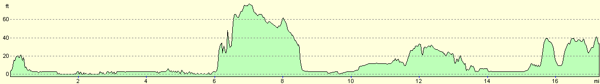
| From | To | Distance (m) | Ascent (ft) | Descent (ft) |
|---|---|---|---|---|
| Southwold Pier | Dunwich | 6.2 | 131 | 102 |
| Dunwich | Sizewell | 5.1 | 115 | 131 |
| Sizewell | South Warren in Aldeburgh | 5.9 | 171 | 154 |
This makes a total distance of 17.2 miles, with 417 feet of ascent and 387 feet of descent.
For more information on profiles, ascents and descents, see this page
Accommodation
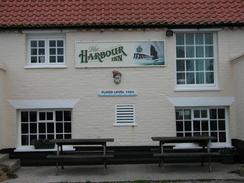
We stayed at the campsite attached to the Vulcan Arms public house, Sizewell, Leiston, IP16 4UD. They can be contacted on (01728) 830748. This site cost us five pounds for the night, which is okay considering the fact that the site does not have a shower. The toilet and sink basin are in the pub, and so are only accessible during the pub's opening hours.
Disclaimer
Please note that I take no responsibility for anything that may happen when following these directions. If you intend to follow this route, then please use the relevant maps and check the route out before you go out. As always when walking, use common sense and you should be fine.
If you find any information on any of these routes that is inaccurate, or you wish to add anything, then please email me.
All images on this site are © of the author. Any reproduction, retransmissions, or republication of all or part of any document found on this site is expressly prohibited, unless the author has explicitly granted its prior written consent to so reproduce, retransmit, or republish the material. All other rights reserved.
Although this site includes links providing convenient direct access to other Internet sites, I do not endorse, approve, certify or make warranties or representations as to the accuracy of the information on these sites.
And finally, enjoy your walking!
This walk was mentioned in the following routes:
| My walk around the coastline of Britain |
Nearby walks
| # | Title | Walk length (miles) |
|---|---|---|
| 132 | Wickham Market Station to Darsham Station | 12.7 |
| 135 | Darsham Station to Brampton Station | 12.3 |
| 259 | Gorleston-on-Sea to Southwold | 18.1 |
|
|

|