Walk #259: Gorleston-on-Sea to Southwold
 |
 |
|
General Data
| Date Walked | 07/11/2002 |
| County | Norfolk, Suffolk |
| Start Location | Gorleston-on-Sea |
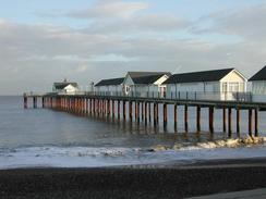
| End Location | Southwold Pier |
| Start time | 08.04 |
| End time | 15.25 |
| Distance | 18.1 miles |
| Description | This was a long but enjoyable cliff and beach walk, heading south from Gorleston-on-Sea to the lovely town of Southwold, passing through Lowestoft on the way. |
| Pack | Today I carried my 30-litre Karrimor HotRock rucksack, which was filled with my packed lunch, waterproof leggings, water bottle and a couple of spare shirts, together with the usual assortment of odds and ends. |
| Condition | I feel relatively okay after this walk. My left ankle was aching at times, but this came and went and fortunately did not cause me any major discomfort. Yet again I do not have a blister, which I find quite amazing after walking foe so many days. The biggest problem at the moment is my back, which is aching quite a lot and I do not know why. |
| Weather | The weather today was gorgeous, particularly when compared with yesterday when it rained solidly all day. The day was mostly sunny, with only a few cloudy periods to spoil what was otherwise a glorious day. Three was a little wind, but not enough to annoy or trouble me in any way. It was another quite warm day for the time of year, although first thing in the morning I was quite cold and had to wear my balaclava to keep my face warm. |
| OS map | Landranger number 134 (Norwich & The Broads, Great Yarmouth) and Landranger number 156 (Saxmundham, Aldeburgh & Southwold) |
 |
 |
|
 |
 |
|
Map of the walk
Maps courtesy of Google Maps. Route for indicative purposes only, and may have been plotted after the walk. Please let me have comments on what you think of this new format. For a detailed table of timings for this walk, please see the table file.
 |
 |
|
 |
 |
|
Notes
Southwold is the home of the Adnams brewery, who make rather nice beer. For this reason this evening we went into the centre of the town and visited the Sole Bay pub, which is an Adnams Inn and part of the brewery, and had a couple of pints of beer which gave me an overwhelming feeling of Southwoldishness.
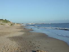
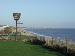
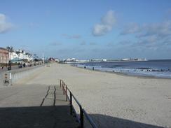
Southwold itself is an absolutely superb little town. It is nice to see a pier that seems very unspoilt, with a lovely entrance building and at night it is lit up with the lights glittering off the sea in a beautiful way. Of all the towns I have seen on the coastline so far Southwold is probably the nicest - the seafront is unspoilt by amusement arcades which are something I am starting to hate in seaside towns their garish colours and neon lights spoiling the views. Indeed it has everything a seaside town should have - a lighthouse, a beach, a lovely seaside promenade. The place is clean and tidy, and the architecture is quite lovely. This town is definitely worth a visit.
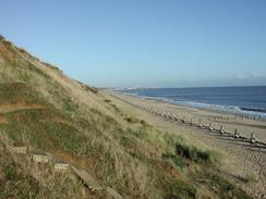
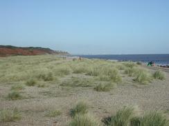
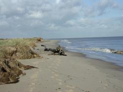
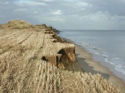
On the way from Lowestoft to Kessingland I decided to walk along a path along the top of the cliffs which is marked on the OS map. This could well have been a mistake, as at a couple of places the path had disappeared down the cliff and so I had to take great care getting around the falls. In one place the path was trapped between a fence beside a caravan park and the cliff, but the path had fallen into the sea for a couple of yards. I made my way over this section by holding onto the sturdy fence and judicious use of one of my walking poles. I would most certainly not advise anyone to use this route, and people should walk along the beach if the tide is out or take a more inland route if the tide is high.
I have walked through Lowestoft in the past, but I had never walked through the southern part of the town. This was really nice, and the promenade past the pier was lovely. It made a dramatic contrast to Great Yarmouth, which was a totally different form of seaside town.
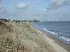
At Lowestoft Ness I came across a large circular marker on the seawall that marks the easternmost point of the mainland of Great Britain. This is the first cardinal point on the coastline I have reached, and the second will be the southernmost point at Lizard Point in Cornwall. This is a few months away, and seems so far as to be not worth thinking about. One funny point was that Edinburgh was marked as being 316 miles away as the crow flies, but I had walked over double that from there along the coast.
 |
Directions
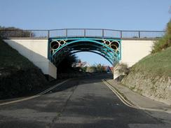
This walk starts off at the seafront at Gorleston-on-Sea, which is to the south of Great Yarmouth. Join the promenade and follow it southwards alongside Gorleston Cliffs. The seawall narrow and then ends, and the sea defences then comprise of wooden slats angled towards the cliffs. These end and the beach continues onwards and just after a golf course ends on the cliffs above a set of metal steps lead up onto the cliffs above.
Immediately at the top of the cliffs turn left and follow a path that heads southwards along the top of the cliffs between the cliffs and a caravan park. The path continues on, passing the little village of Hopton on Sea and then crossing over the Norfolk / Suffolk border. As the path approaches Corton it heads inland alongside a hedge and meets a road.
Turn left and follow this road as it heads south through the village. On the southern edge of the village the road ends at a T-junction with the B1385 road. Continue straight on at this junction, passing a holiday park on the left and an area of woodland on the right. At the bottom of the hill turn left and follow a footpath for a hundred yards until it ends at the cliff.
At the cliff head down the steps and onto the beach before turning right to head southwards along the beach. After a kilometre the north beach car park is reached, where the sea wall begins. Climb up onto the sea wall and follow it southwards for a little over a mile until Lowestoft Ness, he most easterly point in Britain, is reached.
From Lowestoft Ness continue on until the seawall ends by the harbour. Turn right and climb some steps over the seawall and join a road that heads westwards past the harbour to a roundabout. At the roundabout turn left along a road that heads south for a short distance before curving to the right towards the station. Before the station is reached turn left and cross a bridge over the entrance to the inner harbour and on the other side of the bridge turn left to head through a car park past the tourist information and on towards a sea wall.
Turn right and head south down the sea wall, passing Claremont Pier before the seawall ends. If the tide is low you can walk along the beach all the way to Kessingland and then Southwold, but if it is high then you have to take a more inland route. Between Pakefield and Kessingland I attempted to take a cliff top footpath that is marked on the OS maps, but I would advise people not to use this path; in places it is severely eroded and in two places non-existent. The Suffolk Coast and Heath Path booklet describes a more inland route that can be followed on this stretch.
Once I had reached Kessingland I joined the beach as the tide had now been going out for a few hours. Continue on along the beach and cross over the sluice to the Latymere Dam on a bridge. It is then simply a case of following the beach as it heads southwards, although I did take a cliff top path for the section between Benacre Broad and Covehithe Broad. The walk ends at the pier in Southwold, which is situated just south of the end of the Easton Cliffs.
Distances
| From | To | Distance (m) | Ascent (ft) | Descent (ft) |
|---|---|---|---|---|
| Gorleston-on-Sea | Lowestoft | 7.5 | 328 | 358 |
| Lowestoft | Kessingland | 4.7 | 187 | 194 |
| Kessingland | Southwold | 6.0 | 174 | 180 |
This makes a total distance of 18.1 miles, with 689 feet of ascent and 732 feet of descent.
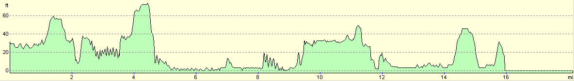
For more information on profiles, ascents and descents, see this page
Accommodation
We stayed in the van on the seafront in Southwold, which was only the second time that we have not stayed in a site on this trip. It is getting increasingly hard to find sites near to where I am finishing the walks as winter comes along, so from tonight we may try and find a campsite only every other night. This has the added benefit of saving money as we will not need to pay site fees.
Disclaimer
Please note that I take no responsibility for anything that may happen when following these directions. If you intend to follow this route, then please use the relevant maps and check the route out before you go out. As always when walking, use common sense and you should be fine.
If you find any information on any of these routes that is inaccurate, or you wish to add anything, then please email me.
All images on this site are © of the author. Any reproduction, retransmissions, or republication of all or part of any document found on this site is expressly prohibited, unless the author has explicitly granted its prior written consent to so reproduce, retransmit, or republish the material. All other rights reserved.
Although this site includes links providing convenient direct access to other Internet sites, I do not endorse, approve, certify or make warranties or representations as to the accuracy of the information on these sites.
And finally, enjoy your walking!
This walk was mentioned in the following routes:
| My walk around the coastline of Britain |
Nearby walks
| # | Title | Walk length (miles) |
|---|---|---|
| 136 | Lowestoft to Caister-on-Sea | 14.4 |
| 167 | Brampton to Lowestoft | 12.3 |
| 257 | Rudram's Gap to Caister-on-Sea | 17.5 |
|
|

|