Walk #136: Lowestoft to Caister-on-Sea
General Data
| Date Walked | 03/02/2001 |
| County | Norfolk, Suffolk |
| Start Location | Lowestoft Station |
| End Location | Caister-on-Sea Post Office |
| Start time | 10.01 |
| End time | 15.50 |
| Distance | 14.4 miles |
| Description | A lovely walk following the coastal paths and a few roads north from Lowestoft and through Great Yarmouth. |
| Pack | I did not carry a pack today. |
| Condition | I am slightly fatigued, but nothing unusual considering I have completed a reasonable distance today. I had a few twinges from my back which was strange but not concerning, and also a couple of twinges from my ankle when walking through soft sand on the beach. For the first time in ages my feet are more or less fine because I used my old pair of boots. |
| Weather | The day started off misty and damp, with a certain amount of mizzle in the air. There were occasional periods of heavier rain, but nothing that lasted too long. The weather slowly cleared up and by lunchtime the cloud was sometimes broken. Later on there were even glimpses of the sun, which made a nice change from recent walks. The day was also thankfully reasonably warm for the time of the year. |
| OS map | Landranger number 134 (Norwich & The Broads, Great Yarmouth) |
 |
 |
|
Map of the walk
Maps courtesy of Google Maps. Route for indicative purposes only, and may have been plotted after the walk. Please let me have comments on what you think of this new format. For a detailed table of timings for this walk, please see the table file.
 |
Notes
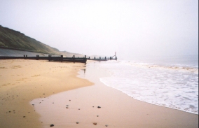
This was a very nice walk which was made even better by the fact that I extended it and did two or three more miles at the end that I had been planning to do. The most strenuous part of the day was all the beach walking - where the sand was soft it made the going quite considerably harder. For this reason where possible I kept to walking on the sea wall which proved to be much easier going.
The Ship pub in Casiter where I stopped to wait for the bus has won national awards for flowers (as far as I can recall it was the Britain In Bloom contest), and pictures inside the pub showed hundreds of flower baskets outside the place. It is quite a nice pub inside as well, although the bitter was not the best that I have ever had.
Great Yarmouth was not the best seaside town that I have ever visited, but neither was it the worst. The main centre was quite busy and bustling with people. However it was definitely out of season and the majority of the shops along the seafront were shut. The Britannia Pier was an abomination, looking very plastic and ugly. It would be nice to see such piers as they would have been when built in Victorian times before they were quite so commericalised.
A high point of the day came quite near the start, when I reached the Ness in Lowestoft. This is the most easterly point of England, and it had a big dial on the seawall stating distance to the other three cardinal points (north, south and west), along with other points such as Land's End and John O'Groats. It is weird to see how small the distances to these points are directly, and it shows how much my Land's End to John O'Groats walk winds about the country.
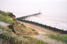
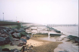
There have obviously been some fairly major storms recently - when walking north from the Ness in Lowestoft there was a section of the seafront with absolutely no sand or shingle on it as it had all been washed away, exposing the remains of an old sea wall that had been demolished after the new one had been built. It was an interesting testament to the furious power of the sea.
Fortunately I managed to avoid doing much road walking as either beaches or clifftop paths could be followed. The only major piece of road walking was from Gorleston on Sea to Great Yarmouth, where I had to follow roads to get to the first bridge crossing of the River Yare. Some sections of the clifftop path north of Corton had slipped into the sea (by the looks of it fairly recently), which meant that you had to divert into the field to avoid falling onto the beach below. In other places the path was very near the edge of the cliff - literally a foot's width away.
Both Lowestoft and Great Yarmouth are working ports, with many small an medium-sized ships docked in the port. Great Yarmouth used to have one of the longest quays in Europe, stretching down from the bridge of the Yare to the sea at Gorleston on both sides of the river. Lowestoft occasionally builds oil and gas rigs for the North Sea oil and gas industry, and later on when the weather had cleared a gas rig could just be made out in the distance on the skyline. There is a heliport just south of Casiter-on-Sea, and whilst I was walking from Great Yarmouth I saw two helicopters take off and land.
Finding somewhere to eat in Lowestoft tonight proved to be a slight problem - I started off by trying the pub opposite where my car was parked, but they did not serve any food. I waited forty-five minutes whilst I wrote this journal and drunk a pint of coke before setting off on a quest to find a pub that served food in the centre of the town. After trying six pubs - all of which did not serve food (some in spite of signs and menus outside them) - I eventually found a place called "Bar Moosh" in Lowestoft High Street which was a wine bar / restaurant. I felt very out of place in my slightly muddy clothes, but hunger won over sartorial elegance and I enjoyed some very nice but rather expensive food.
Be careful when walking this route; if the tide is high or the weather is bad then it could be dangerous; in particular the stretch beneath the cliffs between Corton and Gorleston did not have many escape routes if the tide trapped you.
Directions
This walk starts at Lowestoft Station. Turn right out of the station forecourt and cross the road to the McDonalds restaurant. Turn left down station square and enter the pedestrianised shopping street of London Road North, which has shops all the way down it. When London Road North meets Gordon Road turn right down Gordon Road until you meet a roundabout. Cross over the roundabout and head east down Hamilton Road until you reach the seawall. Take the steps onto the top of the seawall and start walking north along it for about 500 metres until you reach Lowestoft Ness, the most easterly point in England.
Follow the sea wall from the Ness as it heads north for about two kilometres to the car park at North Beach. If the tide is out then you can continue along the beach for another kilometre to TM 5472 9640, where there are some steps that lead up the cliff beside the Pleasurewood Hills park to the B1385 road. The seawall does continue from here into Corton, but it was closed off for long-term repairs when I was there. When you reach the B1385 turn right and follow it through some woodland to the village of Corton.
If the weather is bad or the tide is high, turn left at the North Beach car park and follow 'The Ravine' road uphill to meet the B1385. Turn right and follow the B1385 north to Corton.
When the B1385 turns sharply to the left continue straight on down 'The Street' into Corton. At the northern end of the village the road bends to the left and then to the right to start heading towards the church. After the right-hand bend a footpath leads off to the right across a field to the cliffs. When the cliffs are reached turn left and follow the edge of the cliff northwards.
After about 1500 metres a ramp leads down onto the beach. If the weather is okay and the tide is not high you can descend to the beach and follow it north for about three and a half miles to the northern tip of Gorleston Beach.
At the end of the beach in Gorleston at about TG 5306 0300 turn left and head onto the seafront. From here it is a case of walking northwards for three and a half kilometres, keeping the River Yare to the right. Head towards the front of the Theatre and turn right and the left to join Quay Road. Follow Quay Road northwards and then turn right down Riverside Road. Follow this road northwards as it joins another road. At a junction turn right down Southtown Road and head northwards until you meet the A1243 Bridge Road. Turn right down Bridge Road past a Matalan superstore and cross the bridge over the River Yare.
On the other side of the bridge turn right down South Quay for a short distance before turning left and heading east through the town via Regent Road to the seafront at North Drive and the Britannia Pier.
Follow the seafront northwards, taking either the beach, North Drive or the seawall. When North Drive starts to head behind some dunes take to the beach and follow it northwards past the racecourse at Caister to the very obvious IRB Station at Caister, which is painted a very garish bright red.
Turn left at the IRB station and leave the beach. head through the car park and take Tan Lane which heads westwards through the southern outskirts of Caister past the Ship public house. The bus stop at the Post Office in Caister is just to the left down the High Street when Tan Lane ends.
Distances
| From | To | Distance (m) | Ascent (ft) | Descent (ft) |
|---|---|---|---|---|
| Lowestoft Station | Corton | 3.3 | 138 | 75 |
| Corton | Gorleston-on-Sea | 4.2 | 269 | 305 |
| Gorleston-on-Sea | Britannia Pier, Great Yarmouth | 3.6 | 66 | 95 |
| Britannia Pier, Great Yarmouth | Caister-on-Sea | 3.3 | 23 | 16 |
This makes a total distance of 14.4 miles, with 496 feet of ascent and 491 feet of descent.
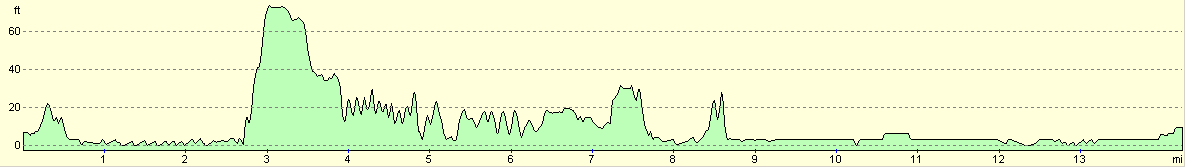
For more information on profiles, ascents and descents, see this page
Transport
There are busses every half hour (or hour on Saturdays) between Caister-on-Sea and Lowestoft, with the journey taking about an hour and calling at many villages en route. There is also a train service from Great Yarmouth to Lowestoft, but this goes via Norwich and can extend journey times considerably.
Accommodation
I spent the night sleeping in my car in the railway station car park in Lowestoft. I know that this was slightly naughty, but I could not see the point in paying for accommodation when my car was so handy. I was also within easy staggering distance of a pub, which was also handy.
Disclaimer
Please note that I take no responsibility for anything that may happen when following these directions. If you intend to follow this route, then please use the relevant maps and check the route out before you go out. As always when walking, use common sense and you should be fine.
If you find any information on any of these routes that is inaccurate, or you wish to add anything, then please email me.
All images on this site are © of the author. Any reproduction, retransmissions, or republication of all or part of any document found on this site is expressly prohibited, unless the author has explicitly granted its prior written consent to so reproduce, retransmit, or republish the material. All other rights reserved.
Although this site includes links providing convenient direct access to other Internet sites, I do not endorse, approve, certify or make warranties or representations as to the accuracy of the information on these sites.
And finally, enjoy your walking!
This walk was mentioned in the following routes:
| A walk around East Anglia |
Nearby walks
| # | Title | Walk length (miles) |
|---|---|---|
| 155 | Caister-on-Sea to Sea Palling | 12.5 |
| 167 | Brampton to Lowestoft | 12.3 |
| 257 | Rudram's Gap to Caister-on-Sea | 17.5 |
|
|

|