Walk #135: Darsham Station to Brampton Station
 |
 |
|
General Data
| Date Walked | 27/01/2001 |
| County | Suffolk |
| Start Location | Darsham Station |
| End Location | Brampton Station |
| Start time | 09.00 |
| End time | 13.20 |
| Distance | 12.3 miles |
| Description | This was a relatively boring walk along roads and a few footpaths through Suffolk. This was mainly a positioning walk to allow me to get to Lowestoft. |
| Pack | I did not carry a pack today. |
| Condition | I have a bad hotspot developing on the ball of my left foot that was causing me a little discomfort towards the end of the walk. Otherwise I was fine, and could easily have continued on for another six miles to Beccles. From now on I will start walking with my rucksack again, slowly increasing the weight until I am carrying full kit, hopefully by March. |
| Weather | The night before had featured some fairly heavy rain, and so it was with a little trepidation that I made the decision to do this walk. The day started off bright but very cold, and the wind was very cold when I was caught in exposed places. As the day went on this became less noticeable and it became warmer. There were a couple of rain showers during the day but these did not last for more than ten minutes and my coat hardly got damp. There were also some quite prolonged periods of sunshine which helped warm me up. |
| OS map | Landranger number 156 (Saxmundham, Aldeburgh & Southwold) |
Map of the walk
Maps courtesy of Google Maps. Route for indicative purposes only, and may have been plotted after the walk. Please let me have comments on what you think of this new format. For a detailed table of timings for this walk, please see the table file.
Notes
Another day, another walk. I had set myself the target for January of walking the whole way from Ipswich to Lowestoft, which I calculated would be about four day's walking. I did one of those days at the very end of last year, so I had three days left to do and this walk now means that this is down to one day, from Brampton to Lowestoft.
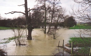
It was a great shame that the weather today was not as nice as it could have been, for areas of the countryside on this walk were actually quite pleasant and the weather did spoil it slightly. That said, however, I have walked in far worse weather and we did see the sun periodically during the day. Last night in Cambridge we had some very heavy rainfall which included sleet and snow at times. This meant that the ground for today's walk was extremely boggy, and in places there were large puddles lying on ground that was already saturated after a very wet autumn.
About this time last year, at the end of my walk from Reading to Slough following the Thames Path, I lost a day's walking notes whilst attempting to follow an ill-marked footpath. Ever since then I have been slightly paranoid about losing my notes and so I always carefully put them back. When walking between Bunkers Hill Farm and Bramfield House this morning I felt in the pocket where I usually keep my notes and I could not find them, so I checked all my pockets and still they could not be located. Since I knew that I had had it out five minutes before when I had reached the road I decided to go back and search for it. I walked back to the road and then along it, scanning the ground for the pad and pen until I reached the place where I knew I had last had it. Unfortunately I still could not find it, so I searched my pockets again and found them in one of the map pockets in my Foraker jacket. DOH!
When I reached Halesworth I spent a little while looking around the town for a newsagents and a chemists; I wanted the newsagents so that I could purchase the latest copy of 'Private Eye' and the chemists so that I could get some blister plasters. Unfortunately the chemists only had small Compeed plasters, so I had to make do with some (in my experience) inferior Scholl ones. I then walked down to the station where I sat down for five minutes and read a little of the magazine. With hindsight I should have used this opportunity to apply a plaster to the ball of my left foot which had been aching, but rather stupidly I did not. Hindsight is such a wonderful thing ;*(
Halesworth itself is a fairly attractive little town, with a pleasant pedestrianised main shopping street and some old buildings. It was very busy with Saturday lunchtime shoppers whilst I was there, which gave the town some life. Unfortunately there were some unattractive areas as well, which is usual for most towns.
When I was approaching Brampton Station I realised that I could be able to catch the 13.32 train from the station back to Darsham so I decided to up the pace slightly. I reached the station just over ten minutes before the train was due, but as I did not feel fatigued I considered going on for an extra six miles to Beccles. This would have upset my planned walks slightly, but would have been a nice end to the day, particularly as there was a Trig point on the way. Since my left foot had a hotspot I sat down on the station and applied one of the Scholl plasters to the effected part of my foot. Unfortunately when I stood up this part hurt even more, so I decided not to extend the walk any further which was a shame.
I now only have one day's walking to do to get to Lowestoft, which will be a nice feeling as it was my target for January. I then have four days walking to do to get to Cromer, but I will probably leave that section for nicer weather later on in the year as it could well involve lots of walking along beaches.
Directions
The first part of this walk unfortunately involves walking along a main road, the A12(T). Fortunately for this distance there is a footpath that can be used to separate you from the traffic. Leave Darsham station and head north-northeastwards along the A12(T), passing a petrol station on the right. Pass White House Farm and take the first road to the left. This road leads to the northwest and crosses the railway line at a level crossing before turning to head westwards.
The road soon passes to the south of an area of woodland before reaching North Boundary Farm. A footpath leads north from here, crossing a stream on the way. The path then reaches a little track way which it follows for a short period before leaving it to the left across fields to reach another road. I missed the turning off the footpath and ended up following the track to the road. This meant that I had a walk of about three hundred metres westwards to reach the point where the footpath reaches the road.
Turn left for a short distance along the road and then turn right to another footpath. This path leads up Bunkers Hill along the western boundary of Kingstall Wood. At the northern edge of the road the footpath heads northwards to a road by Bramfield House School.
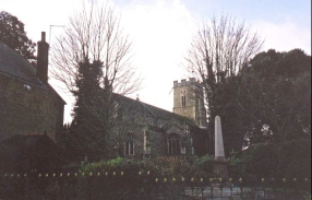
Turn left along the road and head west for about a kilometre. Take the first road to the right and head along it past Walpole Hatch Farm until you meet the B1117. When you meet this road turn right and follow it over a bridge over a stream (that was in flood when I did this walk) and follow it into Halesworth. Walk through the town, passing the church to reach the railway station.
Leave the station and head up the A144 main road. At a roundabout beside a pub take a small road that heads off to the northeast. As this road turns round to the right take a track that heads northwards and crosses the railway line by another road before becoming a minor road again.
When this road meets a crossroads turn right and head east and pass under the railway line and pass to the left of Manor Farm. Shortly after the farm take a road that leads off to the left to a small village. When this road ends at a T-junction turn right and then take the first road to the left. This road heads northwards past Blue Tile Farm and ends at another T-junction. At this junction turn left and head down the hill to Brampton Station.
Distances
| From | To | Distance (m) | Ascent (ft) | Descent (ft) |
|---|---|---|---|---|
| Darsham Station | Halesworth Station | 7.5 | 292 | 282 |
| Halesworth Station | Brampton Station | 4.8 | 138 | 121 |
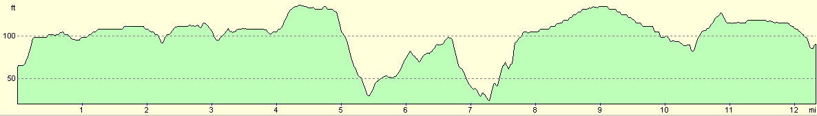
This makes a total distance of 12.3 miles, with 430 feet of ascent and 403 feet of descent.
For more information on profiles, ascents and descents, see this page
Transport
There are trains roughly every two hours between Brampton and Darsham stations, calling at Halesworth en route. The trains are run by Anglia Railways.
Disclaimer
Please note that I take no responsibility for anything that may happen when following these directions. If you intend to follow this route, then please use the relevant maps and check the route out before you go out. As always when walking, use common sense and you should be fine.
If you find any information on any of these routes that is inaccurate, or you wish to add anything, then please email me.
All images on this site are © of the author. Any reproduction, retransmissions, or republication of all or part of any document found on this site is expressly prohibited, unless the author has explicitly granted its prior written consent to so reproduce, retransmit, or republish the material. All other rights reserved.
Although this site includes links providing convenient direct access to other Internet sites, I do not endorse, approve, certify or make warranties or representations as to the accuracy of the information on these sites.
And finally, enjoy your walking!
This walk was mentioned in the following routes:
| A walk around East Anglia |
Nearby walks
| # | Title | Walk length (miles) |
|---|---|---|
| 132 | Wickham Market Station to Darsham Station | 12.7 |
| 167 | Brampton to Lowestoft | 12.3 |
| 260 | Southwold to Aldeburgh | 18.0 |
|
|

|