Walk #391: Strumble Head to Newport
 |
 |
|
General Data
| Date Walked | 22/03/2003 |
| County | Dyfed |
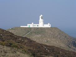
| Start Location | Strumble Head |
| End Location | Newport |
| Start time | 09.00 |
| End time | 17.41 |
| Distance | 18.9 miles |
| Description | This was quit an enjoyable walk, and one with many highly scenic sections. |
| Pack | Today I carried my 30-litre Karrimor HotRock rucksack, which was filled with my packed lunch, waterproof leggings, water bottle and a couple of spare shirts, together with the usual assortment of odds and ends. |
| Condition | I am not feeling very well after this walk, and am quite glad that it is over. For the last couple of hours I was feeling quite nauseous, and whether this was a result of the two pints that I had at lunchtime, the heat or drinking too much water. I also had a headache and was feeling dizzy, which is not the best state to be in when walking along footpaths at the top of cliffs. On a positive note I wore my boots for the first time in a few days, and apart from a little itching my right ankle was fine, so it looks as though the problem that I had with it may have been solved. |
| Weather | Today was another lovely day, with bright skies and very little cloud about. It got quite warm in the afternoon, although the skies were hazy all day, restricting views. There was not much wind to keep me cool, but fortunately it was not too hot. |
| OS map | Landranger number 157 (St David's & Haverfordwest) and Landranger number 145 (Cardigan & Mynydd Preseli) |
 |
 |
|
 |
 |
|
Map of the walk
Maps courtesy of Google Maps. Route for indicative purposes only, and may have been plotted after the walk. Please let me have comments on what you think of this new format. For a detailed table of timings for this walk, please see the table file.
Notes
I started this walk in quite a good mood, as the clouds of yesterday has disappeared and been replaced with bright sunshine. This walk was quite strenuous with many ascents and descents to be made, even on the first section from Strumble Head.
At Carreg Goffa I passed a monument marking the last invasion of the British mainland. On the 22nd February 1797 a force of 1,200 Frenchmen, led by a American, Colonel Tate, landed at Carregwastad Point. They had orders to sack Bristol and start a revolution. The winds did not allow them to land at the city, but they managed to land unopposed at the headland. Colonel Tate made his headquarters at the nearby Tre-Howel farm, and the men looted the area. This probably led to be their undoing, however, as the French got drunk on looted wine and the troops eventually surrendered on Goodwick Sands whilst Colonel Tate signed the surrender document on a table which is now in the Royal Oak pub in Fishguard.
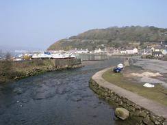
I met Sam at lunchtime on the footpath in Higher Town in Fishguard, and we walked down into the Lower Town to see if we could find a pub. Eventually we found a pub called the Ship Inn, which we entered and I had a quick drink. There were a few people in who were getting ready for the Ireland / Wales six nations rugby match, and I enjoyed looking around the pub, which had many interesting things on the walls. I was not in much of a hurry, and so I decided to have a second pint and relax a little, which with hindsight may have been a mistake.
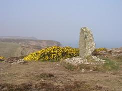
The path does a little loop around Dinas Head, and I quite enjoyed the climb up to the trig point at the top of the hill. I can imagine that on a clear day the views from the top would be expansive, but unfortunately today was too hazy to be able to see very far at all.
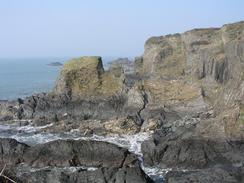
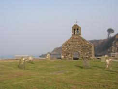
The little village of Cwm-yr-Eglwys below Dinas Head is absolutely superb, and the most noticeable feature in it is the ruined church of St Brynach. Only the western end wall and bellcote remain of this church after it was destroyed in the Royal Charter storm on October 25th 1859, which also wrecked 114 ships off the coast of Wales. The church used to be quite a distance inland and could hold a congregation of 300, which rather belies its current truncated situation.
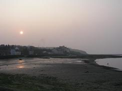
Sam met me about forty minutes before the end of the walk, and we walked together, chatting as we went. By this stage I was feeling decidedly fuzzy in my head, so I was not in a massively talkative mood as I was concentrating on the walk itself. Eventually after what felt like an eternity we reached the car park in Newport where Sam had parked Mervan, and I could take my rucksack off and relax for the rest of the evening.
Tomorrow is my thirtieth birthday, and Sam has booked us into a B&B in Cardigan for the night as a treat. This will be only the second time on the trip (nearly six months) that I will be sleeping in a proper bed, and that should be very nice. This means that I have to reach Cardigan from Newport, a distance of about sixteen or seventeen miles, although it is over tough terrain. The guidebook says that the walk to St Dogmaels (the end of the Pembrokeshire Coast Path near Cardigan) should take eight hours to walk, although I hope that I should be able to do it in less time than that.
Directions
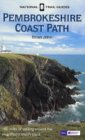
| This walk follows the Pembrokeshire Coast Path, the route of which is detailed in the Ordnance Survey National Trail Guide 7, Pembrokeshire Coast Path (ISBN 1-85410-770-4). Unfortunately the route description is written in reverse to the direction that I am walking, but the 1:25,000 maps in the book are clear and the signs on the ground are very good. Please click on the image to the right to go to the Amazon page for this book. |
 |
Distances
| From | To | Distance (m) | Ascent (ft) | Descent (ft) |
|---|---|---|---|---|
| Strumble Head | Lower Town, Fishguard | 7.9 | 1886 | 1991 |
| Lower Town, Fishguard | Newport | 11.0 | 2605 | 2608 |
This makes a total distance of 18.9 miles, with 4491 feet of ascent and 4599 feet of descent.
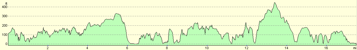
For more information on profiles, ascents and descents, see this page
Accommodation
We parked Mervan at the caravan site at Tycanol Farm, Newport, Pembrokeshire SA42 0ST. They can be contacted on (01239) 820264, and the site cost us ten pounds for the night. The site is right by the coastal path a short distance to the west of Newport, although I walked on a little way into the centre of the town.
Disclaimer
Please note that I take no responsibility for anything that may happen when following these directions. If you intend to follow this route, then please use the relevant maps and check the route out before you go out. As always when walking, use common sense and you should be fine.
If you find any information on any of these routes that is inaccurate, or you wish to add anything, then please email me.
All images on this site are © of the author. Any reproduction, retransmissions, or republication of all or part of any document found on this site is expressly prohibited, unless the author has explicitly granted its prior written consent to so reproduce, retransmit, or republish the material. All other rights reserved.
Although this site includes links providing convenient direct access to other Internet sites, I do not endorse, approve, certify or make warranties or representations as to the accuracy of the information on these sites.
And finally, enjoy your walking!
This walk was mentioned in the following routes:
| My walk around the coastline of Britain |
| Pembrokeshire Coast Path |
Nearby walks
| # | Title | Walk length (miles) |
|---|---|---|
| 390 | Abereiddy to Strumble Head | 16.1 |
|
|

|