Walk #263: Bawdsey to Waldringfield
 |
 |
|
General Data
| Date Walked | 11/11/2002 |
| County | Suffolk |
| Start Location | Bawdsey |
| End Location | Waldringfield |
| Start time | 07.40 |
| End time | 14.30 |
| Distance | 17.9 miles |
| Description | This was a lovely walk following the River Deben upstream to Woodbridge and then back down the western side as far as Waldringfield. |
| Pack | Today I carried my 30-litre Karrimor HotRock rucksack, which was filled with my packed lunch, waterproof leggings, water bottle and a couple of spare shirts, together with the usual assortment of odds and ends. |
| Condition | I feel absolutely fine after this walk. I had no real problems all day, and I could easily have walked further if the campsite had been further away. Yet again I have no blisters, and I had no real aches or pains at any time. |
| Weather | The weather today was a direct contrast to yesterdays: it was sunny for most of the day and there was not much wind to complain about. It was really t-shirt weather, although I wore my coat as all my kit was stored in it. All in all it was lovely day for a nice walk. |
| OS map | Landranger number 156 (Saxmundham, Aldeburgh & Southwold) and Landranger number 169 (Ipswich & The Naze, Clacton-on-sea) |
 |
 |
|
 |
 |
|
Map of the walk
Maps courtesy of Google Maps. Route for indicative purposes only, and may have been plotted after the walk. Please let me have comments on what you think of this new format. For a detailed table of timings for this walk, please see the table file.
 |
 |
|
 |
Notes
This was a lovely walk in some lovely walk, and more than made up for the disappointment of yesterday. The walk upstream to Woodbridge, which was the first place that I could cross the River Deben, was nice, and consisted of a combination of roads, tracks and footpaths.
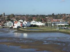
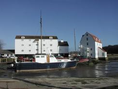
Woodbridge is a lovely little town, which I have walked through before on a walk northeastwards from Ipswich. The most attractive part of the walk along the riverside is the old tidal mill, which had a seven and a half acre pond, which filled up with water at high tide. The water in this pond was released at low tide and was used to drive the sixty-foot diameter water wheel. This was the last working mill of its type in the country, and it ceased operation in 1957. The old mill pond has been converted into a marina for yachts, but the buildings are well cared for and look beautiful in the sun. I spent twenty minutes easting my lunch, sheltering from the slight wind in a shelter on the sea front. It was an ideal place to sit and make a few phone calls, all the time watching the people sitting on benches by the river throwing titbits to the birds. It was a lovely sight, and relaxed me considerably before I had to set off on the rest of the days walk.
On the way to Woodbridge I had to pass Little Sutton Hoo, which is adjacent to the world-famous site of Sutton Hoo. This is where in 1939 the largest treasure haul in Britain was found - fifteen million pounds worth of gold, silver and jewels in the grave of a Saxon King. There is a visitor centre on the site, but unfortunately I could not spare the time to nip in and have a look around. This is a continual gripe that I have about this walk - there are many places that I would not mind nipping in to see, but I cannot afford the hour or two off any walk, particularly at this time of year with the short daylight hours.
Whilst I was walking along the fringe of the woodland above Ferry Cliff I saw a strange animal run out of the woodland and across the field in front of me. It was the size of a large dog, but was running with a peculiar gait that I had not seen a dog run with before. At first I thought that it may be a wild pig, but it was dark in colour and relatively thin. Next I thought that it may be a young fallow deer without antlers, but that did not look quite right either. I studied it as it ran across the field, but I still have no idea about exactly what it was. (Later information, 27/10/2004: A reader has sent in some information saying that it was a Muntjac Deer; having looked at the pictures, I believe that she is right. Many thanks).
When I was planning he walk I had planned to walk down from Bawdsey to Bawdsey Quay, and then walk along the road back to Bawdsey. When I got to the car park this morning I really could not be bothered with this long detour, and so I decided to head inland instead. From the account in his book it sounds as if John Merrill walked from Bawdsey Quay to Ramsholt Quay along he river bank; but there is no right of way along this and the last thing I wanted to be doing was fighting my way through thick vegetation or thick mud (most paths seem to be muddy to some extent at the moment) along a path that is not a right of way. This brings up the question of what is a coastal walk - I have already taken routes that are not public rights of way many times on this trip, but I try not to do it where possible, and particularly if it involves many miles, as this diversion would have.
From the church in Martlesham I had several choices about how I could work my way back downstream along the river. The most obvious rout was by means of a footpath that ran back along the southern edge of Martlesham Creek and then headed southeastwards along the riverbank to Martlesham. This path seems ideal, but if you look closely at the map it shows a breach in the bank and a large area behind the breach being tidal marshland. This left me with a quandary; it could be possible to walk over the breach, or there could be a bridge over it; however if I reached the breach and realised that I could not get over it then a long walk back would be necessary. For this reason I decided to chicken out and walked along the road, which was a more direct route and passed the campsite where we are staying the night. There is the same situation tomorrow morning, with a breach in the bank between Waldringfield and Hemley, which will probably mean that I will have to walk along roads and tracks between the two villages.
Directions
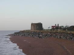
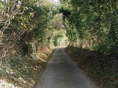
This walk starts off at the car park at the end of East Lane, Bawdsey, beside the sea wall. Leave the car park and head westwards along the road, passing East Lane Farm on the left. At a junction turn right past the primary school and follow the road around until it ends at the B1083 road near the church. At the junction turn right up the B1083 and follow it northwards past the church and out of the village. Within a mile it reaches the village of Alderton.
In Alderton follow the road around as it swings to the left past the church. When it swings around to the right continue straight on down a road that heads westwards. After two kilometres this road swings around to the right near Peyton Hall and heads slightly uphill. Take the first road of to the left and follow this road for a kilometre until it ends at Ramsholt Quay, with a nice-looking pub beside it.
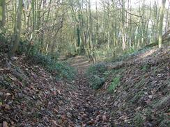
From the quay turn right and follow a footpath that heads northwestwards along the eastern bank of the river. This path winds around and climbs up and down as it progresses on, passing over Shottisham Creek via a sluice. It then settles down to run on or alongside the riverbank northwards to Stonner Pont, which is on the opposite side of the river to where this walk ends at Waldringfield. From Stonner Point continue on along the riverside path and enter the area of woodland on the western side of Nettle Hill. Here I went wrong, probably due to fallen trees blocking the proper path, and climbed up through the woodland to Cliff Farm whilst the proper path continues on low beside the river. From Cliff Farm head northwest along a surfaced track that ends at a T-junction with another track in Methersgate.
At the junction turn left and head westwards towards the hall. When the track ends turn right and go through part of a farm and follow a footpath that heads northwards. The path crosses two surfaced tracks before coming to the edge of an area of woodland. Follow the path around the left-hand side of the woodland and follow it as it turns to the left and descends down Ferry Cliff. At the bottom of Ferry Cliff turn right and skirt the riverbank along a secluded and muddy path through the woodland before climbing over the riverbank and heading inland towards the buildings at Little Sutton Hoo. When a track is reached in Little Sutton Hoo turn left down it and follow it as it swings around to the right. Immediately after the bend turn left down another track that heads northwards, and is marked with a blue circular walk marker. Continue on along this track as it enters some woodland and turns to the right to head northeastwards before eventually ending at the A1152 road.
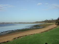
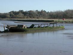
Turn left and follow the A1152 road northeastwards as it crosses Wilford Bridge over the River Deben. Continue on along the road, passing a pub on the right before getting to a car park for a country park on the left. Enter this car park and turn right over a little footbridge until you are opposite Melton Station. Turn left and follow another footpath over another footbridge and onto a footpath at the top of the riverbank. Turn right and follow the riverbank southwestwards towards Woodbridge. The path enters marinas and diverts away through industrial areas, but it is all well signposted and so navigation is easy. Pass the large and attractive white buildings of the tidal mill and continue on until the riverside path reaches Woodbridge Station.
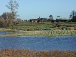
From the station continue onwards along the riverside path as it heads southwestwards along a good surfaced footpath. When it reaches the promontory at Kingston it descends down to the high-water line and turns around to head westwards. The first section of this path is very boggy as it is below the high water line; this path may not be passable at high tide. This section soon ends and the path rises up on top of the riverbank as it heads westwards along the northern bank of Martlesham Creek. At the very western end of the creek turn left along the bank and head south over a sluice. The riverbank ends at the southern edge of the creek, but the path continues on into some woodland and climbs uphill and onto a surfaced road.
At the road turn left and follow it to Martlesham Church. The road then becomes a track which turns sharply to the right and descends downhill towards a farm before climbing uphill and ending at another road. At this road turn left and follow it asoutheastwards as it descends past Howe's Farm to cross over a stream before ascending up the other side of the valley towards Waldringfield. The campsite was a short distance along the first road to the right.
Distances
| From | To | Distance (m) | Ascent (ft) | Descent (ft) |
|---|---|---|---|---|
| Bawsey | Woodbridge | 13.7 | 541 | 538 |
| Woodbridge | Waldringfield | 4.2 | 203 | 141 |
This makes a total distance of 17.9 miles, with 744 feet of ascent and 679 feet of descent.
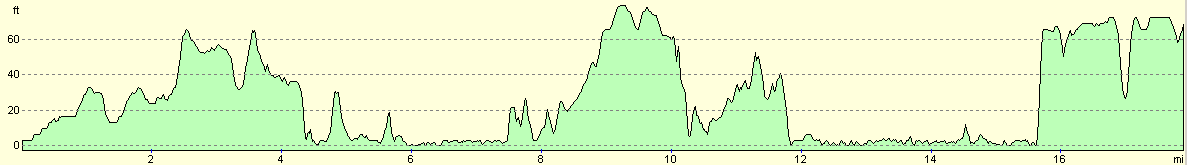
For more information on profiles, ascents and descents, see this page
Accommodation
We stayed at the campsite at Low Farm, Ipswich Road, Waldringfield, Woodbridge, Suffolk IP12 4QU. This was a lovely site that cost us eight pounds for the night, plus two pounds for three loads of washing. The owner also gave us a bottle of Australian champagne, which was very nice and went down well with the fish that we had for dinner. This site was the best that we have stayed on for a few days, with a nice, warm and (shock, horror), adjustable shower. They can be contacted on (01473) 736314.
Disclaimer
Please note that I take no responsibility for anything that may happen when following these directions. If you intend to follow this route, then please use the relevant maps and check the route out before you go out. As always when walking, use common sense and you should be fine.
If you find any information on any of these routes that is inaccurate, or you wish to add anything, then please email me.
All images on this site are © of the author. Any reproduction, retransmissions, or republication of all or part of any document found on this site is expressly prohibited, unless the author has explicitly granted its prior written consent to so reproduce, retransmit, or republish the material. All other rights reserved.
Although this site includes links providing convenient direct access to other Internet sites, I do not endorse, approve, certify or make warranties or representations as to the accuracy of the information on these sites.
And finally, enjoy your walking!
This walk was mentioned in the following routes:
| My walk around the coastline of Britain |
Nearby walks
| # | Title | Walk length (miles) |
|---|---|---|
| 131 | Ipswich to Wickham Market Station | 16.7 |
| 132 | Wickham Market Station to Darsham Station | 12.7 |
| 262 | Chillesford to Bawdsley | 10.8 |
|
|

|