Walk #651: Malvern to Ledbury
 |
 |
|
General Data
| Date Walked | 26/02/2005 |
| County | Herefordshire, Worcestershire, Gloucestershire |
| Start Location | Malvern Link station |
| End Location | Ledbury station |
| Start time | 09.14 |
| End time | 15.47 |
| Distance | 16.4 miles |
| Description | This was a hard but exhilarating walk, taking in the full length of the Malvern Hills before a low-level stroll into Ledbury. |
| Pack | Today I carried my 30-litre Karrimor rucksack, filled with my usual set of detritus and kit. |
| Condition | I am fairly tired after this walk, but I suffered no significant problems and after a little rest I could easily have walked further. |
| Weather | Today's weather was quite mixed; it started off with a mixture of sunshine and cloud, and as the day went on the cloud became thicker. Early on there was a short snow flurry, although this did not last long and was not repeated. It was a reasonably warm day, although when I was at a high level and exposed to the wind it was relatively chilly. |
| OS map | Landranger number 150 (Worcester & The Malverns, Evesham & Tewkesbury) and Landranger number 149 (Hereford & Leominster, Bromyard & Ledbury) |
 |
 |
|
 |
 |
|
Map of the walk
Maps courtesy of Google Maps. Route for indicative purposes only, and may have been plotted after the walk. Please let me have comments on what you think of this new format. For a detailed table of timings for this walk, please see the table file.
 |
 |
|
Notes
It had been my intention to do a three-day walk along the North Down's Way over an extended weekend, but as this week went on it became clear that I would have to cancel my holiday on Monday. This left me with a decision about what to do, and I soon settled on doing this walk over the Malvern Hills, which I have wanted to do for years. I therefore set off at a little past six thirty this morning for the long drive to Malvern. The journey was very good on clear roads, and just before nine I pulled up in the car park at Malvern Link railway station. As I had been sitting in the car for so long I walked around a little and stretched my leg muscles, before putting my rucksack on and heading off down the road.
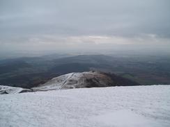
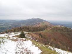
It was a joy to see that the very top of the hills were covered in snow, and I was in a good mood as I headed down the A449 road towards the centre of Malvern. There were a couple of interesting features that I saw as I walked; an unusually shaped post box and a water fountain standing alone on the other side of the road. I soon found myself leaving the A449 and heading uphill along the B4232 until I reached a car park on the left beside a lovely brick tower. From here a steep ascent followed to the north along a muddy path that soon had me panting for breath. Some steps took me higher before the path headed up a deep gully; as soon as I could I left this, and climbed up to join a path that headed into a little saddle between North Hill and Table Hill. In the process I entered the snowline, and I left the track to head up through some fairly virgin snow to the top of North Hill. The views from here were superb, with the Cotswold Hills clearly visible through the haze to the southeast.
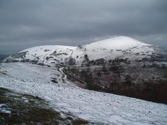
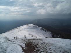
The wind was making the summit quite a chilly spot, so I carefully started making my way back down the path towards the col. I loved listening to my boots crunching through the snow, and I soon found myself at the summit of Sugar Loaf Hill, from where the next summit of Worcestershire Beacon was clearly visible. There were many paths that I could take to get there, and I tried to stick as much as possible to the ridgeline. The rocks around the summit viewpoint were covered with icicles and hoar frost, and was also surrounded by many people so that I was dissuaded from looking at it. Instead I settled on heading to the adjacent trig pillar, which was also covered in icicles. There were too many people around for me to want to spend too long there, so I followed a broad track that headed southwards. The going was exceptionally easy and I soon found myself climbing up to the little summit of Summer Hill before passing a car park and reaching the main road at the Wyche Cutting.
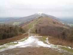
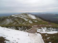
An easy walk took me up to the summit of Perseverance Hill and back into patches of snow, and then onto the higher Jubilee Hill and finally Pinnacle Hill. The views were superb, and I was very aware of how prominent the Malvern Hill range is amongst the surrounding low-lying land. By this stage I was really enjoying the walk, and the paths underfoot meant that my legs were not complaining too much about the continual climbing and falling. Black Hill led down to a long descent to the main road at British Camp Pass, and I was pleasantly surprised to find a refreshment stall near to the hotel. I studied the various wares on display and eventually settled on a bacon bap, and when it was ready I scoffed it as I walked uphill towards the summit of British Camp Hill, which is also known as Herefordshire Beacon. This hillside is ringed by a series of earthworks that were quite fascinating to study as I walked past, and they left me wondering if they had defended a settlement or whether this windy, exposed location was only used in times of crisis; I could easily imagine that the plains below were a much easier place to live and farm.
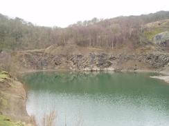
The path continued on and was easy to follow as it headed south over Millennium Hill and Hangman's Hill before reaching Silurian Pass. A last climb up Swinyard Hill followed, before the descent down to the pass at The Gullet. Here I took an incorrect route; when the well-worn path jinked to the right I took a path that continued straight on. This path met the fence guarding the very top of The Gullet Quarry, before descending down on an easterly course to meet a track that led me to a car park. This meant that I was slightly east of where I had wanted to be, so I followed a track that headed past the quarry, the bottom of which was filled with water that almost shone with a glorious green tint. This belied the great depth of the water, and it left me wondering exactly when the quarry had closed.
My next target was to climb up towards the summit of Midsummer Hill. Unlike the hills further north the paths over these southern Malvern Hill are less clear, and at the western end of the lake I turn left to climb up a rough path, churned up by horses, that led up the hill. This was a steep climb and I consequently took it slowly, and I was relieved when I reached a track that ran along the top of the hill. I was disappointed, however, to find that this path soon curved round to head northeastwards downhill back towards The Gullet; I wanted to continue straight on southwards, and as an obvious path headed in this direction I decided to follow this. This turned out to be a mistake, as the path soon ended and I was left descending an extremely steep slope through an area populated with small trees. To my right was a fence guarding the quarry face, and I moved a little way away from this for safety. Underfoot the ground was a mixture of loose branches and scree, and on the slope this made the going very difficult. I took my time and used my poles and eventually I could see the tops of cars travelling along the A438 below me. I soon reached the road, and was annoyed to see that there was a four-foot high wall that I had to jump down to get onto the road. This was difficult as there was no verge on the road and if I slipped I would fall straight onto the carriageway, so I sat down on the top of the wall, checked both ways, jumped down and ran across the road to the pavement on the other side.
Here I met a gentleman who was doing some gardening, and as we chatted he said that many people made the same mistake when coming off the hill. It turned out that for the last part of the descent I had headed through his orchard, and I apologised for this and he gave me an alternative route to get to Ledbury. After thanking him I headed off along the road, and I soon headed off along another rough path that headed around the western side of Raggedstone Hill. I did not get to see the summit of this hill, and the path was quite muddy in places, and for this reason I was quite relieved when I reached the road at White Leaved Oak Pass. My next target was the summit of the southern hill of the Malvern range, Chase End Hill, on which there is a trig pillar. An obvious path headed through some woodland, and on the map it skirted the summit. I cold see the trig pllar standing on the hill above, and I was just wondering how I could get up to it when the path diverted to the left and headed steeply uphill to the pillar.
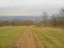
The views from the pillar were lovely, and although not as superb as the views from the higher northern hills they are still quite expansive. I stood by the pillar for a few minutes studying the views before the wind chill started to get to me and I jogged down the hill until I reached a road. This I followed for a while until it reached the hamlet of Bromesberrow, which is only a short distance away from the M50 motorway. Another road then led me onwards to Clencher's Mill, from where I took a path that headed through some woodland. This path followed a track that was exceptionally muddy underfoot, and I soon realised that it was curving north too early. Instead of heading back to see where the proper path had gone I decided to avoid he mud and follow the side of a fenced area to reach the path. This led me across a field towards a farm, and I then joined a road that led me out to the A417 road at Parkway. There was a pavement beside the A417, and this allowed me to stride northwards along the road and make good time.
I soon found myself entering Ledbury, and although the initial scenes of industrial buildings were not salubrious as I entered the town centre the quality of the buildings became much better. There were many fantastic timbered buildings about, including a couple of hotels, and there was a small market below the superbly preserved raised market hall. The whole area was bustling on this Sunday morning, and this added to the atmosphere of the town centre. I was really enchanted and I would have stayed around for longer to explore except for the fact that I knew that the next train to Malvern was expected shortly. I strode down to the railway station, and as I had a little over a quarter of an hour to spare I went into a shelter to book some accommodation in Ledbury for the night. This proved no problem, and I soon found myself boarding the train for the journey back to Malvern Link. This proved to be very cheap as no ticket collector came down the train, the first time this had happened to me for some time. It had been a highly enjoyable day's walk, and one that I can definitely see myself repeating in some form at another time.
Considering that today's walk involved 4,400 feet of climbing (essentially the same height as Ben Nevis) I feel remarkably good after this walk, which is a very good sign for the TGO Challenge walk that I am doing in a couple of months. I have come away from today's walk with no blisters and no other significant problems, and although I did not carry as much weight as I will be doing on the Challenge I am feeling much more positive than I was before today's walk.
Directions
This walk starts off at the car park of Malvern Link railway station. Leave the station by the small gap that leads onto the A449 road and start following this as it heads southwestwards. When the road curves to the left turn right to start heading uphill along the B4219 road, passing a church on the left. This road meets the B4232 road; continue straight on along the latter until a car park and a brick tower is reached on the left. Walk a few yards past the entrance road to the car park before turning left up a footpath. This soon climbs a series of steps to ascend the hillside between two quarries before entering a little gully. Continue along the footpath up this gully as it heads between North Hill and Table Hill; when a track is met continue on up to the col between the two hills. At the col you can turn left to climb up to the top of North Hill, from where there are some substantial views. Head back down to the col, from where a network of paths fan out towards Worcestershire Beacon.
I chose to take an obvious but less well-walked path that took me south to the summit of Sugar Loaf Hill before descending and then climbing up to a viewpoint and trig pillar. A clear path leads south from here, and this soon becomes a surfaced track as it heads down past Summer Hill and a car park before reaching a road and some public toilets at The Wyche. Cross the road and take a footpath that heads uphill to the left of the public toilets. The path is obvious as it reaches the summits of Perseverance Hill, Jubilee Hill and Pinnacle Hill, before descending down to Black Hill. The path eventually diverts to the right to reach the B4232 road; turn left along this for a hundred yards until it reaches the A449 road beside a hotel at British Camp Pass.
Cross the A449 road and take a footpath that heads uphill to the right of the car park. As soon as possible leave the obvious surfaced path and turn right to climb up some steps that lead to the top of British Camp Hill, otherwise known as Herefordshire Beacon. A clear path then leads down across the hill, leading to Millenium Hill and Hangman's Hill. The path descends down to Silurian Pass before climbing up towards the top of Swinyard Hill. At the top of the hill the path forks; the main path to the right heads down to the west of The Gullet quarry, whilst the one I took headed along the summit for another hundred yards before following the fence guarding the quarry westwards, descending downhill before joining a track that ends at a road beside a car park.
Once on the A438 road turn right and walk westwards along the road through Hollybush. Pass a car park on the right and then turn left down a path that skirts the western side of Raggedstone Hill. The path does not climb up to the summit, but instead keeps relatively low on the hillside, heading through a wooded area before suddenly emerging onto a road at White Leaved Oak. Head down the short road until it ends after a few yards at a road junction, and then turn right and almost immediately to the left to start following a narrow path southwards over Chase End Hill. The path climbs uphill through woodland until a clearing is reached by the trig pillar at the top of the hill. Leave the pillar and head south along an obvious path; this descends downhill before reaching a road.
Turn to the left and follow this road as it heads in a rough westerly direction for a kilometre before curving to the left to head southwards to end at a road junction near the village cross in Bromesberrow. Turn right to start heading slightly north of westwards along a road that leads for a little over a mile to Clencher's Mill. The road crosses a ford over a stream and then turns sharply to the right to head uphill. After a few yards turn left along a muddy track that enters some woodland, following a broad track through the tress that slowly curves to the right to head northwards before ending at a road beside a farm. Join this road and follow it as it heads westwards for about half a mile until it ends at the A417 road at Parkway.
Turn right and start following the A417 northwards; when a roundabout is reached after a kilometre continue straight on as the road enters Ledbury and heads northwards through the centre of the town. As the road approaches the northern outskirts of the town it curves sharply to the left; immediately before the bend turn right up the station approach road that ends at Ledbury railway station, where this walk ends.
Distances
| From | To | Distance (m) | Ascent (ft) | Descent (ft) |
|---|---|---|---|---|
| Malvern Link station | British Camp Hill | 6.0 | 2215 | 1473 |
| British Camp Hill | Bromesberrow | 5.9 | 1220 | 2041 |
| Bromesberrow | Ledbury station | 4.5 | 410 | 351 |
This makes a total distance of 16.4 miles, with 3845 feet of ascent and 3865 feet of descent.
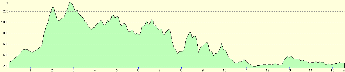
For more information on profiles, ascents and descents, see this page
Transport
There are regular train services between Ledbury and Malvern Link, calling at Colwall Stone and Malvern on the way. I do not know how much the train costs as the ticket office at Ledbury was closed and no ticket collector came down the train. Please see the National Rail Enquiries website for more details.
Accommodation
I spent the night at The Elms B&B, 52 Guarlford Road, Malvern, Worcestershire WR14 3QP, telephone 01684 573466. This was a nice B&B where I was made to feel very welcome; the Bluebell Inn is a short stagger down the road. AS twin room cost me thirty pounds for night as a single occupant.
Disclaimer
Please note that I take no responsibility for anything that may happen when following these directions. If you intend to follow this route, then please use the relevant maps and check the route out before you go out. As always when walking, use common sense and you should be fine.
If you find any information on any of these routes that is inaccurate, or you wish to add anything, then please email me.
All images on this site are © of the author. Any reproduction, retransmissions, or republication of all or part of any document found on this site is expressly prohibited, unless the author has explicitly granted its prior written consent to so reproduce, retransmit, or republish the material. All other rights reserved.
Although this site includes links providing convenient direct access to other Internet sites, I do not endorse, approve, certify or make warranties or representations as to the accuracy of the information on these sites.
And finally, enjoy your walking!
Nearby walks
| # | Title | Walk length (miles) |
|---|---|---|
| 652 | Ledbury to Hereford | 17.1 |
| 698 | Worcester to Malvern | 11.4 |
| 707 | Worcester to Kidderminster via Bewdley | 22.2 |
|
|

|