Walk #650: A circular walk from Cheddleton to Rudyard Lake
 |
 |
|
General Data
| Date Walked | 21/02/2005 |
| County | Staffordshire |
| Start Location | Cheddleton |
| End Location | Cheddleton |
| Start time | 08.28 |
| End time | 14.34 |
| Distance | 17.4 miles |
| Description | This was a highly enjoyable stroll, taking in parts of the Staffordshire Way and a near-complete circuit of the beautiful Rudyard Lake. |
| Pack | Today I carried my 30-litre Karrimor rucksack, filled with my usual set of detritus and kit. |
| Condition | I feel absolutely fine after this walk, and have no problems to report. The toe that gave me trouble yesterday was fine, and with a little rest I have no doubt that I could have continued on further. |
| Weather | Heavy snow was forecast for today, but aside from a few flurries this did not eventuate. It was a bitterly cold day when I was exposed to the full force of the wind, but conversely when the sun was shining (which it did frequently) I was a little too warm. |
| OS map | Outdoor Leisure number 24 (The Peak District - White Peak Area) |
 |
 |
|
 |
 |
|
Map of the walk
Maps courtesy of Google Maps. Route for indicative purposes only, and may have been plotted after the walk. Please let me have comments on what you think of this new format. For a detailed table of timings for this walk, please see the table file.
 |
 |
|
Notes
It had been my intention to spend today walking from either Stoke to Crewe (and hence connecting up my previous walks with the Kidsgrove to Stockport stretch that I did this weekend) or Stockport to Bury through Manchester. Neither of these appealed massively, however, and as I was driving back from Macclesfield last night I looked down from the A523 road to see the expanse of Rudyard Lake. I have never walked around this lake before, and so I resolved to walk around it today.
I had two options about where to start the walk; it was tempting to start it in Leek, from where I have walked previously, but to extend the walk I decided to start in Cheddleton, where I also guessed that it would be easier to park. I had one major worry, however; heavy snow was forecast for the afternoon, and after the walk I knew that I had a three-hour drive back to Cambridge to contend with. For this reason I set off fairly early, and arrived in Cheddleton in good time. I decided the base the walk near the preserved railway station of the North Staffordshire Railway at Cheddleton, and when I arrived I found that the car park was unsurprisingly closed as trains were not running. I drove on the short distance to the canal, and although there was a nearly empty car park there was a sign stating that it was for use of customers in the adjacent pub only. I therefore drove on up the hill, and found a place to park on a residential street about a hundred yards away.
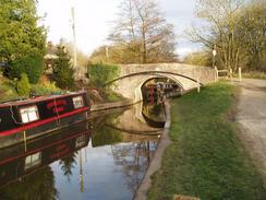
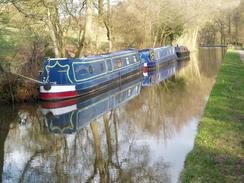
The Caldon Canal in Cheddleton is lovely, and I enjoyed my walk along it westwards towards the two locks by the A520 road. The sun was shining overhead and the ground underfoot was crisp; it felt like a truly beautiful day. Even the existence of a high, unwelcoming fence to my right (protecting the canal from the adjacent industrial park and vie versa) did not bother me. I soon passed the locks and left Cheddleton, to walk onwards for about a mile along the canal towpath. The canal soon joined the disused Leekbrook Junction to Stoke railway line, which despite being unused for some years appeared to be in remarkably good condition and not overgrown. (I have since found out that the line was recently cleared for some reason).
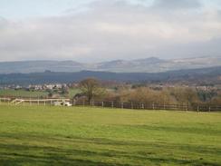
At Horse Bridge I left the canal and started walking along the road, soon crossing over the Leek Branch of the Caldon Canal, which leaves the main canal about a kilometre to the west. A track took me off the road and led me along the inside edge of an attractive heath land area before dumping me unceremoniously out onto the A53. I had to follow this for a short distance before heading eastwards across the Ladderedge Country Park. The views from the high points of this were spectacular, with The Roaches being clearly visible in the distance above Leek. I really enjoyed the walk, and shortly before I reached the car park for the park I stopped to chat to a couple that were out walking.
From the car park I started following the long canal feeder stream that runs from Rudyard Lake south to the Leek Branch of the Caldon Canal a short distance east of the car park. The walk was nice and easy albeit slightly boggy, and I made good time. To my right a water company was doing some major works, but I could see no sign of exactly what except for the long area of churned up and disturbed earth. At the northern end of Cowhay Wood grey clouds started to gather overhead, and I considered shortening the walk by cutting back to the old railway line and following that back into Leek; I was concerned about the weather and the long drive home. Fortunately I continued on, and soon crossed the B5331 road at Harper's Gate and reached the dam of Rudyard Reservoir.
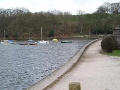
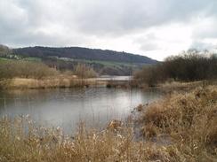
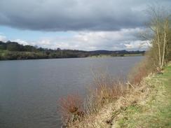
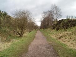
The reservoir was completed in 1797 to provide water to the Caldon Canal, and became a popular tourist location once the North Staffordshire Railway opened the railway line that ran along the eastern bank in 1849. Allegedly the famous author Rudyard Kipling was named after the lake, as his parents met there. An easy path took me along the western bank of the river, and although the reservoir was mostly obscured from view by houses and trees, it was nonetheless a lovely walk. I soon reached the car park at the northern end, and started to follow the trackbed of the old Leek to Macclesfield railway line southwards. From here I got some much better views of the lake, and near Hunthouse Wood the footpath was joined by a narrow gauge railway line that operates in summer.
When I reached the southern end of the lake I had been intending to follow a footpath southeastwards to the A523 road, which would have meant a noisy last mile into Leek. I was therefore glad to see that the footpath continued south along the railway trackbed, passing a car park and the southern terminus of the narrow gauge railway before continuing on southeastwards into Leek. The only point of any real note on the walk was a bridge that was under restoration. As I approached Leek it started to hail and then snow, and so I stopped under a bridge to take my fleece off and put my coat on. Predictably as soon as I had done this it stopped snowing, and I saw no more snow until the last mile of the walk. In leek the old railway line dived into a tunnel, and not only is the tunnel closed, the southern portal has been totally buried. I therefore had to leave the railway trackbed and follow local roads into the centre of leek.
Leek is quite a nice little town with some attractive buildings, and I enjoyed my walk through, especially as two teenage girls wolf-whistled at me as I walked towards the market! Wondering where they had left their glasses I continued on, nipping into the W.H. Smiths in the town centre to buy a magazine before heading out of the town along the A523 road. I left this at Padwick, and followed a bridleway southwestwards as it headed down towards the A520 on Birchall. After passing under a railway bridge carrying the disused Caldon Low railway line overhead I left the A520, to follow Basford Lane south. This road was nice and quiet, and as I approached the top of the hill it started to snow once again. This made the walk even nicer, and as I headed along the last footpath downhill towards Cheddleton Station I felt very contented. I soon reached the canal bridge and therefore the end of the walk, and I am please to say that the journey back to Cambridge was unhampered by the snow that sporadically fell.
Directions
This walk starts off by Bridge 44 on the Caldon Canal, a short distance down the road from Cheddleton Station on the North Staffordshire Railway. The first few miles of the walk follows the Staffordshire Way, which is a reasonably well waymarked walk in this locality. When facing the canal from the adjacent car park turn right to head under the bridge and then follow the canal as it heads westwards for a little under a kilometre until two locks bridge 42, which carries the A520 over the canal, is reached. From here follow the canal towpath as it continues on northwestwards, turning to the left alongside an old railway line before reaching bridge 39. Here leave the canal and turn right to start heading northwards along the road; it immediately crosses the railway line on a bridge and then, a short distance further on, it crosses the Leek Branch of the Caldon Canal.
A few yards uphill from the Leek Branch Canal Bridge a road comes in from the left; here turn right along a minor road that initially heads eastwards before curving around to head in a more northeasterly direction. The road soon ends and a rough bridleway continues onwards, before eventually joining a minor road that ends at the A53 road. Turn left along the A53 for a few hundred yards, using the pavement on the northern side of the road until a track leads off to the right. Follow this track for a few yards, and then join a footpath that heads off to the right. This squeezes between two fences before descending down into Ladderedge Country Park. The Staffordshire Way through the park is well waymarked, and it eventually leads out into a car park beside the A53.
At the point where the path enters the car park cross a little stream to get onto its northern bank, and then turn left to start following the stream as it heads westwards. The stream is actually a feeder supply for the Caldon Canal, and it soon curves to head northwestwards and finally northwards before ending at the base of Rudyard reservoir dam, about two and a half miles from the car park. The path climbs up the dam before following a track along the western side of the reservoir. The track ends near a house at Cliffe Park, and a footpath continues on, following another track to a car park at the northern end of the lake.
Here this walk leaves the Staffordshire Way; at the car park turn right and started following the trackbed of the old North Staffordshire railway line southeastwards along the eastern bank of the reservoir. The going is very easy, and once the lake ends continue on for a little over a mile and a half until the path ends just under a bridge in the centre of Leek. Here climb up the steps to the left to gain access to a road. Follow this eastwards to join North Street, and when this ends at West Street follow this eastwards until it ends at the A523(T). Head along this for a few yards until a church is reached on the left, and then turn right to head south along the A520 Compton Street. Take the first road on the left, and then join Derby Street, which heads eastwards before ending at roundabout that has a clock tower standing in the middle.
Head almost directly across the roundabout to join the A523(T) Ashbourne Road as it heads southeastwards out of Leek. The road passes a police station and a little hospital; when a petrol station is reached on the right and the road swings around in the same direction continue straight on along a minor road that diverges from the main road. This road climbs up a slight hill before turning to the right to cross the A523(T) on a bridge. Continue along this road as it heads southwestwards; it ends at Home Farm and a bridleway continues straight on downhill before joining a minor road that soon ends at the A520 in Birchall.
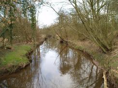
Turn left to follow the A520 downhill to the south; it curves past Sheephouse Farm before passing under a high railway bridge. Immediately after passing under the bridge turn left to join Basford Lane. Initially this lane passes an industrial estate, before climbing uphill to a crossroads. Once at the crossroads continue on along the road as it heads southwards. When Bridge Cliffe Farm is reached on the right turn right to follow a footpath that heads westwards, skirting to the south of the farm before descending downhill to meet a road junction beside Cheddleton railway station. Continue straight on westwards, following Basford Bridge Lane as it crosses the River Churnet and then almost immediately reached Bridge 44 on the Caldon Canal, where this walk ends.
Distances
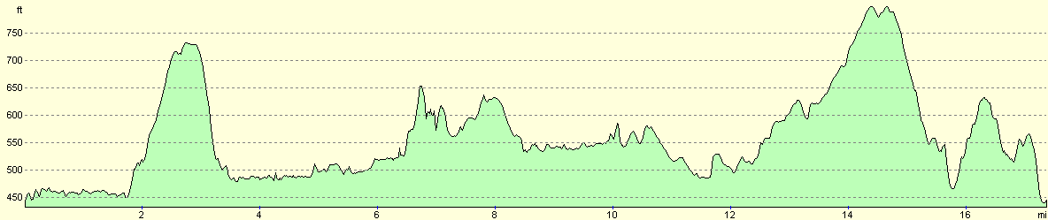
| From | To | Distance (m) | Ascent (ft) | Descent (ft) |
|---|---|---|---|---|
| Cheddleton | Harper's Gate | 6.0 | 610 | 535 |
| Harper's Gate | Leek | 7.5 | 830 | 725 |
| Leek | Cheddleton | 3.9 | 463 | 643 |
This makes a total distance of 17.4 miles, with 1903 feet of ascent and 1903 feet of descent.
For more information on profiles, ascents and descents, see this page
Disclaimer
Please note that I take no responsibility for anything that may happen when following these directions. If you intend to follow this route, then please use the relevant maps and check the route out before you go out. As always when walking, use common sense and you should be fine.
If you find any information on any of these routes that is inaccurate, or you wish to add anything, then please email me.
All images on this site are © of the author. Any reproduction, retransmissions, or republication of all or part of any document found on this site is expressly prohibited, unless the author has explicitly granted its prior written consent to so reproduce, retransmit, or republish the material. All other rights reserved.
Although this site includes links providing convenient direct access to other Internet sites, I do not endorse, approve, certify or make warranties or representations as to the accuracy of the information on these sites.
And finally, enjoy your walking!
Nearby walks
| # | Title | Walk length (miles) |
|---|---|---|
| 579 | A circular walk from Leek, taking in The Roaches | 16.1 |
| 648 | Kidsgrove to Macclesfield | 18.6 |
| 701 | A circular walk along the Manifold Way | 19.0 |
|
|

|