Walk #649: Macclesfield to Stockport
 |
 |
|
General Data
| Date Walked | 20/02/2005 |
| County | Cheshire, Greater Manchester |
| Start Location | Macclesfield station |
| End Location | Stockport |
| Start time | 08.20 |
| End time | 15.06 |
| Distance | 18.4 miles |
| Description | This was an enjoyable walk, taking in canal towpath and footpaths as I headed northwards into Greater Manchester. It was hardly a classic walk, but was highly enjoyable nonetheless. |
| Pack | Today I carried my 30-litre Karrimor rucksack, filled with my usual set of detritus and kit. |
| Condition | I had a little trouble with one of the toes on my right foot towards the end of the day, but this cleared up once I got off the muddy footpaths and onto the roads. There is no sign of any blisters on the toes, so it might just have been the seam of my sock in the wrong place. Aside from this I was fine, and could easily have walked further. |
| Weather | The day started off quite sunny but bitterly cold, and the wind made things worse. The temperature did not increase much as the day went on, although I did feel warmer once the clouds gathered overhead and I got out of the wind. |
| OS map | Landranger number 118 (Stoke-on-Trent & Macclesfield) and Landranger number 109 (Manchester, Bolton & Warrington) |
 |
 |
|
 |
 |
|
Map of the walk
Maps courtesy of Google Maps. Route for indicative purposes only, and may have been plotted after the walk. Please let me have comments on what you think of this new format. For a detailed table of timings for this walk, please see the table file.
 |
 |
|
Notes
Yesterday I did an eleven mile walk around the Chatsworth area with my sister, but I did not log this and so I came onto today's walk wanting to get a good distance done to make up for it. I have been planning to do a walk into Greater Manchester for some time, and this walk was planned to get me quite near the town. It took me longer than I expected to get to Macclesfield, although this was somewhat offset when I pulled into the car park at Macclesfield Station to find that it is free on Sundays - during the other six days of the week it costs five pounds fifty to park all day, and I expect that the car park fills up quite quickly in the morning. I nipped into the station to use the toilet and to ask about the trains; as I expected busses replace the trains on Sundays (due to the seemingly never-ending West Coast Main Line upgrade). The nice lady behind the counter told me that there were busses at 14.30 and 15.00, the former taking an hour and the latter just half an hour to get back to Macclesfield!
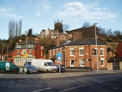
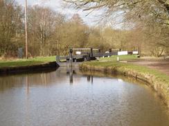
It did not take me long to retrace the steps of Friday's walk to get me to Bridge 34 on the Macclesfield Canal, and as I started following it northwards the only other people I saw were a couple of joggers coming running past me. The sky overhead was bright and sunny and the mud on the path frozen, which made for a very crisp and chilly walk. To the right the high ground of Kerridge Hill looked very inviting, and I shall have to go back there to do a walk sometime, perhaps taking in Shining Tor at the same time. I soon arrived in Bollington, and passed by an old mill that had been converted into offices. A short distance later at the northern end of the town I passed another mill, this one in light industrial use. A cherry picker was doing some work on the outside of the building. The whole canal side scene in Bollington was quite nice, complete with the obligatory children feeding the ducks and although I did not see much of the town I left with quite a warm feeling of it. A man passed by me canoeing along the canal and acting as an icebreaker as he went, the thin layer of ice on the water audibly cracking as he paddled.
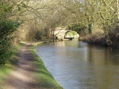
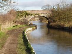
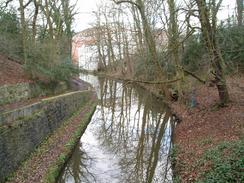
The canal continued northwards, and as I walked the industrial heart of Manchester was visible in the distance to my left, with even the high fells visible in the far distance. The views added to my jovial mood, and I strided along with scarcely a worry in the world as I listened to the latest shenanigans in Ambridge in The Archers. Despite approaching the northwest conurbation the canal remained surprisingly rural until I approached the outskirts of Marple, where streets of houses became prominent for the first time since Bollington. The area around the junction with the Peak Forest Canal in Marple was superlative, with archetypal canal side buildings jostling in around the junctions. I promised myself that I would come back here sometime to walk along the Peak Forest Canal towards Whaley Bridge, but for the moment I turned left and started following a canal westwards as it descended down a long flight of locks. Each of these locks is of quite an elegant design, being of a relatively long drop and with a stone arch bridge on the downstream side of the lock.
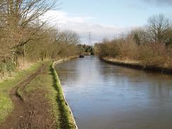
I had been having trouble with the batteries on my GPS; I had tried two sets during the morning but they had soon ran out of juice. I put this down to the batteries performing badly due to the cold temperature; I got slightly better performance out of the second set by keeping them in my trouser pocket to warm them up slightly. By the time I got to Marple I was desperately in need of some batteries, so I headed away from the locks into the centre of the town. I found the co-op easily, and went into it to get myself a couple of spare sets of batteries. Unfortunately it seemed as though the entire town was in the store this lunchtime, and I queued for a long time before eventually getting served. I left with the batteries and a couple of packets of crisps, and headed back to the lock flight through an attractive area of parkland. At the bottom of the flight of locks the canal passed under a railway bridge with deep girders before crossing an aqueduct over the River Goyt. The railway viaduct alongside the canal looked particularly grand, and I took a few photographs of it as I walked past.
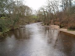
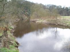
Shortly after the aqueduct the canal passed into a short tunnel, and the towpath climbed up to go over the top. On the way up the steep steps I passed a couple trying to manoeuvre a pram containing an extremely unhappy child up the steps; I offered to help but they said that they were fine. Once the towpath rejoined the canal it passed an industrial area before entering a wooded valley that was extremely nice ton walk through. I was annoyed when I had to leave the canal and head down some steps, passing an inquisitive dog before joining a road that headed past St Chad's Well and then a chapel and down to the A627 road at Chadkirk. When the road turned sharply to the right to cross the River Goyt on a bridge I continued on down a track, following the Midshires Way. It was a highly pleasant stretch of woodland walking, although I did not get to seem much of the River Goyt far below to my left. Eventually I reached a long green bridge that spanned the swirling river below, and once on the other side the footpath continued on along the southern bank of the river.
Again this stretch of footpath made for a very pleasant walk, and despite pain that I was getting in one of my toes I found myself studying the superb views that I got of the river. The path was fairly busy, and it was understandable why - it was a great walk so close to the centre of a conurbation. The path passed a weir before heading past a mill on the other riverbank I decided to try and make a shortcut. This turned out to be a bad idea, and I ended up climbing up a pathless bank before reaching, suddenly and unexpectedly, the bustling Woodbank Park. This meant that I was on the level, and I strode out through the park gates and headed own the roads through Stockport to the railway station. I got there a few minutes past three and, knowing that I had missed the three o'clock bus service, I went in to get a ticket. It turned out that the next bus was not until four, so I left the station and found a pub in which I could have a restful drink whilst I waited. I arrived back at the station in plenty of time to buy my ticket, and the bus ride back to Macclesfield left a few minutes early and arrived within the scheduled thirty minutes, giving me a nice period in which to reflect on a surprisingly enjoyable walk into the northwest conurbation.
Directions
This walk starts off at Macclesfield railway station. Leave the station and walk through the car park to the road, and then turn right and follow the road as it curves around to the right and passes under a railway bridge and immediately reaching a crossroads with a dual carriageway. Cross the dual carriageway and then turn left past an elegant shop frontage. Descend down some steps to reach a road, and follow this as it passes a small car park before joining the B5470 road. Follow this road as it heads uphill to the northeast until bridge 34 on the Macclesfield Canal is reached. Use the steps on the right to descend down to the towpath, and then turn right to head under the bridge and start following the towpath northwards.
Follow the towpath as it heads northwards for ten miles until the junction with the Peak Forest Canal is reached in Marple. At the junction turn left, and start following a canal as it descends northwards down a long flight of locks. When the locks end the canal passes under a railway bridge before crossing the River Goyt on a long aqueduct. From here the canal takes a more westerly course, and when it plunges into a tunnel follow the towpath up a steep slope and then continue along a track that descends downhill. When another track is met at the bottom turn left and then left again, to head down to the western tunnel mouth.
Continue along the canal until SJ939903; here take some steps that lead down to the left to a road. Once at the road turn left and follow it as it immediately curves to the right and plunges down to the valley floor. Here the Midshires Way is joined, which will be followed for the next few miles towards the centre of Stockport. The road is narrow but very quiet as it curves to the right and heads southwestwards before ending at the A627 road. Turn left along this road for a short distance until it curves to the left to cross the River Goyt on a bridge; do not cross the bridge and instead cross the road and continue southwestwards along a track. This track soon curves around to the right twice, to head north for a couple of hundred yards towards a farm.
Here the track curves to the left to head slightly north of westwards, heading near to the northern bank of the River Goyt. Just before the track curves to the right to head away from the river turn left down a footpath that heads down to a long green footbridge over the river. Cross the footbridge, on the other side climb up the bank, and follow the Midshires Way as it follows the southern bank of the river. The path climbs and falls as the river loops around the outside of Woodbank Park; when it climbs up the park proper join a track a few yards away to the left and turn right, to follow this westwards to the entrance of the park.
Leave the park and walk past a museum immediately on the right. Do not take the first road to the left but instead follow it around the bend and start following it as it heads downhill, initially heading westwards before curving to head southwestwards. When this road ends at a main road at a complex junction take a road that heads northwestwards for a few yards, passing to the right of a car dealership before turning left down another road that heads southwestwards until the A6 is reached. Turn right along the A6 for a hundred yards, and then turn left down a road that passes a leisure centre and nightclub before curving around to the right to reach the forecourt of Stockport railway station, where this walk ends.
Distances
| From | To | Distance (m) | Ascent (ft) | Descent (ft) |
|---|---|---|---|---|
| Macclesfield Station | Bollington | 3.4 | 246 | 141 |
| Bollington | Marple | 7.9 | 443 | 453 |
| Marple | Stockport Station | 7.1 | 768 | 1073 |
This makes a total distance of 18.4 miles, with 1457 feet of ascent and 1667 feet of descent.
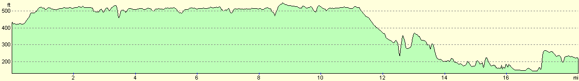
For more information on profiles, ascents and descents, see this page
Transport
There are regular railway service between Stockport and Macclesfield. Unfortunately today the train services are not running, and I had to rely on less frequent bus substitution services; a single ticket cost me Ł3.70.
Disclaimer
Please note that I take no responsibility for anything that may happen when following these directions. If you intend to follow this route, then please use the relevant maps and check the route out before you go out. As always when walking, use common sense and you should be fine.
If you find any information on any of these routes that is inaccurate, or you wish to add anything, then please email me.
All images on this site are © of the author. Any reproduction, retransmissions, or republication of all or part of any document found on this site is expressly prohibited, unless the author has explicitly granted its prior written consent to so reproduce, retransmit, or republish the material. All other rights reserved.
Although this site includes links providing convenient direct access to other Internet sites, I do not endorse, approve, certify or make warranties or representations as to the accuracy of the information on these sites.
And finally, enjoy your walking!
Nearby walks
| # | Title | Walk length (miles) |
|---|---|---|
| 1 | Shining Tor and Cat's Tor from the Cat and Fiddle pub | 7.2 |
| 579 | A circular walk from Leek, taking in The Roaches | 16.1 |
| 614 | A circular walk from the Cat and Fiddle Inn | 17.2 |
|
|

|